

CryoSat-2
Encyclopedia
CryoSat-2 is a European Space Agency
environmental
research satellite
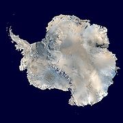
which was launched in April 2010. It provides scientists with data about the polar ice caps and tracks changes in the thickness of the ice with a resolution of about 1/2 in. This information is useful for monitoring climate change.http://www.popsci.com/bown/2010/product/esa-cryosat-2 Cryosat 2 was built as a replacement for CryoSat-1
, whose Rokot carrier rocket was unable to achieve orbit. ESA built a replacement, with software upgrades and greater battery capacity, which carries an interferometric radar range-finder with twin antennas which measures the height difference between floating ice and open water. CryoSat-2 is operated as part of the CryoSat
programme to study the Earth
's polar ice cap
s, which is itself part of the Living Planet
programme. The CryoSat-2 spacecraft was constructed by EADS Astrium
, and was launched by ISC Kosmotras
, using a Dnepr-1 carrier rocket, on 8 April 2010. On 22 October 2010, CryoSat-2 was declared operational following six months of on-orbit testing.
 The initial proposal for the CryoSat programme was submitted as part of a call for proposals in July 1998 for Earth Explorer missions as part of the European Space Agency's Living Planet programme. It was selected for further studies in 1999, and following completion of a feasibility study the mission was authorised. The construction phase began in 2001, and in 2002 EADS Astrium
was awarded a contract to build the spacecraft. A contract was also signed with Eurockot, to conduct the launch of the satellite using a Rokot/Briz-KM carrier rocket.
Construction of the original spacecraft was completed in August 2004. Following testing the spacecraft was shipped to the Plesetsk Cosmodrome
in August 2005, and arrived on 1 September. The launch occurred from Site 133/3
on 8 October, however due to a missing command in the rocket's flight control system, the second stage engine did not shut down at the end of its planned burn, and instead the stage burned to depletion. This prevented the second stage and Briz-KM from separating, and as a result the rocket failed to achieve orbit. The spacecraft was lost when it reentered over the Arctic Ocean
, North of Greenland
.
Due to the importance of the CryoSat mission for understanding global warming
and reductions in polar ice caps, a replacement satellite was proposed. The development of CryoSat-2 was authorised in February 2006, less than five months after the failure.
could affect its readings, and to provide data for calibrating the satellite. In January 2007 the European Space Agency issued a request for proposals for further calibration and validation experiments. Further CryoVEx experiments were conducted on Svalbard
in 2007, followed by a final expedition to Greenland and the Devon Ice Cap
in 2008. Additional snow measurements were provided by the Arctic Arc Expedition, and the Alfred Wegner Institute's ASIRAS instrument, mounted aboard a Dornier Do 228
aircraft.
Like its predecessor, CryoSat-2 was constructed by EADS Astrium, with its main instrument being built by Thales Alenia Space
. Construction and testing of the spacecraft's primary instrument was completed by February 2008, when it was shipped for integration with the rest of the spacecraft. In August 2009, the spacecraft's ground infrastructure, which had been redesigned since the original mission, was declared ready for use. Construction and testing of the spacecraft had been completed by mid-September. The Project Manager for the CryoSat-2 mission was Richard Francis, who had been the Systems Manager on the original CryoSat mission.
CryoSat-2 is an almost-identical copy of the original spacecraft, however modifications were made including the addition of a backup radar altimeter. In total, 85 improvements were made to the spacecraft when it was rebuilt.
were contracted to perform the launch. Due to delays to earlier missions and range availability problems, the launch was delayed until February 2010.
The Dnepr rocket assigned to launch CryoSat-2 arrived at the Baikonur Cosmodrome
by train on 29 December 2009. On 12 January 2010, the first two stages of the rocket were loaded into the launch canister, and the canister was prepared for transportation to the launch site. On 14 January, it was rolled out to Site 109/95
, where it was installed into its silo. The next day saw the third stage transported to the silo, and installed atop the rocket.
Following the completion of its construction, CryoSat-2 was placed into storage to await launch. In January 2010, the spacecraft was removed from storage, and shipped to Baikonur for launch. It departed Munich Franz Josef Strauss Airport aboard an Antonov An-124
aircraft on 12 January, and arrived at Baikonur the next day. Following arrival at the launch site, final assembly and testing were conducted.
During final testing, engineers detected that the spacecraft's X band
(NATO H
/I
/J band
s) communications antenna
was not receiving the amount of power that it should. Thermal imaging showed that the waveguide
was overheating, which suggested it was the cause of the problem. The waveguide could not normally be inspected or repaired without disassembly, however in order to avoid doing so, which would have delayed the launch, a local surgeon
was brought in to inspect the component with an endoscope. The surgeon, Tatiana Zykova, discovered that two pieces of ferrite
were lodged in the tube, and was able to remove one of them, whilst engineers were able to remove the other with a magnet
. It was determined that the ferrite had come from a coating on the antenna, which was intended to improve its performance. Some ferrite was removed from the base of the antenna in order to prevent any further debris falling into the waveguide.
On 4 February, the CryoSat-2 spacecraft was fuelled for launch. Then on 10 February it was attached to the payload adaptor, and encapsulated in the payload fairing
, to form a unit known as the Space Head Module. This was transported to the launch pad by means of a vehicle known as the crocodile, and installed atop the carrier rocket. Rollout occurred on 15 February, and the next day the satellite was activated in order to test its systems following integration onto the rocket.
Following the delay, the Space Head Module was removed from the rocket, and returned to its integration building on 22 February. Whilst it was in the integration building, daily inspections were made to ensure that the spacecraft was still functioning normally. Once the fuel issue had been resolved, the launch was rescheduled for 8 April, and launch operations resumed. On 1 April, the Space Head Module was returned to the silo, and reinstalled atop the Dnepr. Following integrated tests, the practice countdown was successfully conducted on 6 April.
CryoSat-2 was launched at 13:57:04 UTC on 8 April 2010. Following a successful launch, CryoSat-2 separated from the upper stage of the Dnepr into a low Earth orbit
. The first signals from the satellite were detected by a ground station at the Broglio Space Centre in Malindi, Kenya, seventeen minutes after launch.
The primary instruments aboard CryoSat-2 are SIRAL-2, the SAR/Interferometric Radar Altimeters; which uses radar
to determine and monitor the spacecraft's altitude in order to measure the elevation of the ice. Unlike the original CryoSat, two SIRAL instruments are installed aboard CryoSat-2, with one serving as a backup in case the other fails.
A second instrument, Doppler Orbit and Radio Positioning Integration by Satellite
, or DORIS, is used to calculate precisely the spacecraft's orbit. An array of retroreflector
s are also carried aboard the spacecraft, and allow measurements to be made from the ground to verify the orbital data provided by DORIS.
Following launch, CryoSat-2 was placed into a low Earth orbit with a perigee
of 720 kilometres (447.4 mi), an apogee
of 732 kilometres (454.8 mi), 92 degrees of inclination
and an orbital period
of 99.2 minutes. It had a mass at launch of 750 kilograms (1,653.5 lb), and is expected to operate for at least three years.
Launch and Early Orbit Phase operations were completed in the morning of 11 April 2010, and SIRAL-2 was activated later the same day. At 14:40 UTC, the spacecraft returned its first scientific data. Initial data on ice thickness was presented by the mission's Lead Investigator, Duncan Wingham
, at the 2010 Living Planet Symposium on 1 July. Later the same month, data was made available to scientists for the first time. The spacecraft underwent six months of on-orbit testing and commissioning, which concluded with a review on 22 October 2010 that found the spacecraft was operating as expected, and that it was ready to begin operations.
European Space Agency
The European Space Agency , established in 1975, is an intergovernmental organisation dedicated to the exploration of space, currently with 18 member states...
environmental
Environmental science
Environmental science is an interdisciplinary academic field that integrates physical and biological sciences, to the study of the environment, and the solution of environmental problems...
research satellite
Satellite
In the context of spaceflight, a satellite is an object which has been placed into orbit by human endeavour. Such objects are sometimes called artificial satellites to distinguish them from natural satellites such as the Moon....
which was launched in April 2010. It provides scientists with data about the polar ice caps and tracks changes in the thickness of the ice with a resolution of about 1/2 in. This information is useful for monitoring climate change.http://www.popsci.com/bown/2010/product/esa-cryosat-2 Cryosat 2 was built as a replacement for CryoSat-1
CryoSat-1
CryoSat-1, also known as just CryoSat, was a European Space Agency satellite which was lost in a launch failure in 2005. It was to have been operated as part of the CryoSat programme to study the Earth's polar ice caps....
, whose Rokot carrier rocket was unable to achieve orbit. ESA built a replacement, with software upgrades and greater battery capacity, which carries an interferometric radar range-finder with twin antennas which measures the height difference between floating ice and open water. CryoSat-2 is operated as part of the CryoSat
CryoSat
CryoSat is an ESA programme which will monitor variations in the extent and thickness of polar ice through use of a satellite in low Earth orbit. The information provided about the behaviour of coastal glaciers that drain thinning ice sheets will be key to better predictions of future sea-level rise...
programme to study the Earth
Earth
Earth is the third planet from the Sun, and the densest and fifth-largest of the eight planets in the Solar System. It is also the largest of the Solar System's four terrestrial planets...
's polar ice cap
Polar ice cap
A polar ice cap is a high latitude region of a planet or natural satellite that is covered in ice. There are no requirements with respect to size or composition for a body of ice to be termed a polar ice cap, nor any geological requirement for it to be over land; only that it must be a body of...
s, which is itself part of the Living Planet
Living Planet Programme
The Living Planet Programme is a programme within the European Space Agency which is managed by the Earth Observation Programmes Directorate...
programme. The CryoSat-2 spacecraft was constructed by EADS Astrium
EADS Astrium
Astrium Satellites is one of the three business units of Astrium, a subsidiary of EADS. It is a European space manufacturer involved in the manufacture of spacecraft used for science, Earth observation and telecommunication, as well as the equipment and subsystems used therein and related ground...
, and was launched by ISC Kosmotras
ISC Kosmotras
The International Space Company Kosmotras or ISC Kosmotras is a joint project, between Russia, Ukraine, and the Kazakhstan, established in 1997. It developed and now operates a commercial expendable launch system using the Dnepr rocket. The Dnepr is a converted Soviet era SS-18 ICBM decommissioned...
, using a Dnepr-1 carrier rocket, on 8 April 2010. On 22 October 2010, CryoSat-2 was declared operational following six months of on-orbit testing.
Background
EADS Astrium
Astrium Satellites is one of the three business units of Astrium, a subsidiary of EADS. It is a European space manufacturer involved in the manufacture of spacecraft used for science, Earth observation and telecommunication, as well as the equipment and subsystems used therein and related ground...
was awarded a contract to build the spacecraft. A contract was also signed with Eurockot, to conduct the launch of the satellite using a Rokot/Briz-KM carrier rocket.
Construction of the original spacecraft was completed in August 2004. Following testing the spacecraft was shipped to the Plesetsk Cosmodrome
Plesetsk Cosmodrome
Plesetsk Cosmodrome is a Russian spaceport, located in Arkhangelsk Oblast, about 800 km north of Moscow and approximately 200 km south of Arkhangelsk.-Overview:...
in August 2005, and arrived on 1 September. The launch occurred from Site 133/3
Plesetsk Cosmodrome Site 133
Site 133, also known as Raduga , is a launch complex at the Plesetsk Cosmodrome in Russia. It is used by Rockot, and previously Kosmos carrier rockets. It consists of a single pad, originally designated 133/1, and later 133/3....
on 8 October, however due to a missing command in the rocket's flight control system, the second stage engine did not shut down at the end of its planned burn, and instead the stage burned to depletion. This prevented the second stage and Briz-KM from separating, and as a result the rocket failed to achieve orbit. The spacecraft was lost when it reentered over the Arctic Ocean
Arctic Ocean
The Arctic Ocean, located in the Northern Hemisphere and mostly in the Arctic north polar region, is the smallest and shallowest of the world's five major oceanic divisions...
, North of Greenland
Greenland
Greenland is an autonomous country within the Kingdom of Denmark, located between the Arctic and Atlantic Oceans, east of the Canadian Arctic Archipelago. Though physiographically a part of the continent of North America, Greenland has been politically and culturally associated with Europe for...
.
Due to the importance of the CryoSat mission for understanding global warming
Global warming
Global warming refers to the rising average temperature of Earth's atmosphere and oceans and its projected continuation. In the last 100 years, Earth's average surface temperature increased by about with about two thirds of the increase occurring over just the last three decades...
and reductions in polar ice caps, a replacement satellite was proposed. The development of CryoSat-2 was authorised in February 2006, less than five months after the failure.
Development
Following the announcement that CryoSat-2 would be built, experiments were conducted in Antarctica, as part of the CryoVEx programme, to determine how snowSnow
Snow is a form of precipitation within the Earth's atmosphere in the form of crystalline water ice, consisting of a multitude of snowflakes that fall from clouds. Since snow is composed of small ice particles, it is a granular material. It has an open and therefore soft structure, unless packed by...
could affect its readings, and to provide data for calibrating the satellite. In January 2007 the European Space Agency issued a request for proposals for further calibration and validation experiments. Further CryoVEx experiments were conducted on Svalbard
Svalbard
Svalbard is an archipelago in the Arctic, constituting the northernmost part of Norway. It is located north of mainland Europe, midway between mainland Norway and the North Pole. The group of islands range from 74° to 81° north latitude , and from 10° to 35° east longitude. Spitsbergen is the...
in 2007, followed by a final expedition to Greenland and the Devon Ice Cap
Devon Ice Cap
The Devon Ice Cap is an ice cap on eastern Devon Island covering an area of over . The highest point on Devon Island is found at the summit of the ice cap, with an elevation of . The ice cap has a maximum thickness of ....
in 2008. Additional snow measurements were provided by the Arctic Arc Expedition, and the Alfred Wegner Institute's ASIRAS instrument, mounted aboard a Dornier Do 228
Dornier Do 228
The Dornier 228 is a twin-turboprop STOL utility aircraft, manufactured by Dornier GmbH from 1981 until 1998. In 1983, Hindustan Aeronautics bought a production licence and manufactures the 228 for the Asian market sphere. Approximately 270 Do 228 were built at Oberpfaffenhofen, Germany and...
aircraft.
Like its predecessor, CryoSat-2 was constructed by EADS Astrium, with its main instrument being built by Thales Alenia Space
Thales Alenia Space
Thales Alenia Space is an aerospace company born after the Thales Group bought the participation of Alcatel in the two joint-ventures between Alcatel and Finmeccanica, Alcatel Alenia Space and Telespazio.-History:...
. Construction and testing of the spacecraft's primary instrument was completed by February 2008, when it was shipped for integration with the rest of the spacecraft. In August 2009, the spacecraft's ground infrastructure, which had been redesigned since the original mission, was declared ready for use. Construction and testing of the spacecraft had been completed by mid-September. The Project Manager for the CryoSat-2 mission was Richard Francis, who had been the Systems Manager on the original CryoSat mission.
CryoSat-2 is an almost-identical copy of the original spacecraft, however modifications were made including the addition of a backup radar altimeter. In total, 85 improvements were made to the spacecraft when it was rebuilt.
Final preparations
When it was approved in February 2006, the launch of CryoSat-2 was planned for March 2009. It was originally planned that like its predecessor it would be launched by a Rokot, however due to a lack of available launches a Dnepr-1 rocket was selected instead. ISC KosmotrasISC Kosmotras
The International Space Company Kosmotras or ISC Kosmotras is a joint project, between Russia, Ukraine, and the Kazakhstan, established in 1997. It developed and now operates a commercial expendable launch system using the Dnepr rocket. The Dnepr is a converted Soviet era SS-18 ICBM decommissioned...
were contracted to perform the launch. Due to delays to earlier missions and range availability problems, the launch was delayed until February 2010.
The Dnepr rocket assigned to launch CryoSat-2 arrived at the Baikonur Cosmodrome
Baikonur Cosmodrome
The Baikonur Cosmodrome , also called Tyuratam, is the world's first and largest operational space launch facility. It is located in the desert steppe of Kazakhstan, about east of the Aral Sea, north of the Syr Darya river, near Tyuratam railway station, at 90 meters above sea level...
by train on 29 December 2009. On 12 January 2010, the first two stages of the rocket were loaded into the launch canister, and the canister was prepared for transportation to the launch site. On 14 January, it was rolled out to Site 109/95
Baikonur Cosmodrome Site 109
Site 109/95 at the Baikonur Cosmodrome is a missile silo built for use by the R-36 missile, which has been converted into a launch site for the Dnepr-1 carrier rocket....
, where it was installed into its silo. The next day saw the third stage transported to the silo, and installed atop the rocket.
Following the completion of its construction, CryoSat-2 was placed into storage to await launch. In January 2010, the spacecraft was removed from storage, and shipped to Baikonur for launch. It departed Munich Franz Josef Strauss Airport aboard an Antonov An-124
Antonov An-124
The Antonov An-124 Ruslan is a strategic airlift jet aircraft. It was designed by the Ukrainian SSR's Antonov design bureau, then part of the Soviet Union. It is the world's largest ever serially-manufactured cargo airplane and world's second largest operating cargo aircraft...
aircraft on 12 January, and arrived at Baikonur the next day. Following arrival at the launch site, final assembly and testing were conducted.
During final testing, engineers detected that the spacecraft's X band
X band
The X band is a segment of the microwave radio region of the electromagnetic spectrum. In some cases, such as in communication engineering, the frequency range of X band is rather indefinitely set at approximately 7.0 to 11.2 gigahertz . In radar engineering, the frequency range is specified...
(NATO H
H band
H band can refer to two different regions of the electromagnetic spectrum, in the radio and near-infrared.-Radio:The H band is the range of radio frequencies from 6 GHz to 8 GHz in the electromagnetic spectrum. This is equal to wave lengths between 5 cm and 3.75 cm...
/I
I band
The I band is the range of radio frequencies from 8 GHz to 10 GHz in the electromagnetic spectrum. This is equal to wave lengths between 3.75 cm and 3 cm. The I band is in the SHF range of the radio spectrum....
/J band
J band
J band can refer to two different regions of the electromagnetic spectrum, in the radio and near-infrared.-Radio:The J band is the range of radio frequencies from 10 GHz to 20 GHz in the electromagnetic spectrum. This is equal to wave lengths between...
s) communications antenna
Antenna (radio)
An antenna is an electrical device which converts electric currents into radio waves, and vice versa. It is usually used with a radio transmitter or radio receiver...
was not receiving the amount of power that it should. Thermal imaging showed that the waveguide
Waveguide
A waveguide is a structure which guides waves, such as electromagnetic waves or sound waves. There are different types of waveguides for each type of wave...
was overheating, which suggested it was the cause of the problem. The waveguide could not normally be inspected or repaired without disassembly, however in order to avoid doing so, which would have delayed the launch, a local surgeon
Surgeon
In medicine, a surgeon is a specialist in surgery. Surgery is a broad category of invasive medical treatment that involves the cutting of a body, whether human or animal, for a specific reason such as the removal of diseased tissue or to repair a tear or breakage...
was brought in to inspect the component with an endoscope. The surgeon, Tatiana Zykova, discovered that two pieces of ferrite
Ferrite (iron)
Ferrite or alpha iron is a materials science term for iron, or a solid solution with iron as the main constituent, with a body centred cubic crystal structure. It is the component which gives steel and cast iron their magnetic properties, and is the classic example of a ferromagnetic material...
were lodged in the tube, and was able to remove one of them, whilst engineers were able to remove the other with a magnet
Magnet
A magnet is a material or object that produces a magnetic field. This magnetic field is invisible but is responsible for the most notable property of a magnet: a force that pulls on other ferromagnetic materials, such as iron, and attracts or repels other magnets.A permanent magnet is an object...
. It was determined that the ferrite had come from a coating on the antenna, which was intended to improve its performance. Some ferrite was removed from the base of the antenna in order to prevent any further debris falling into the waveguide.
On 4 February, the CryoSat-2 spacecraft was fuelled for launch. Then on 10 February it was attached to the payload adaptor, and encapsulated in the payload fairing
Payload fairing
Payload fairing is one of the main components of a launch vehicle. The fairing protects the payload during the ascent against the impact of the atmosphere . More recently, an additional function is to maintain the cleanroom environment for precision instruments.Outside the atmosphere the fairing is...
, to form a unit known as the Space Head Module. This was transported to the launch pad by means of a vehicle known as the crocodile, and installed atop the carrier rocket. Rollout occurred on 15 February, and the next day the satellite was activated in order to test its systems following integration onto the rocket.
Launch
When the spacecraft was installed atop the Dnepr, launch was scheduled to occur on 25 February, at 13:57 UTC. Prior to this, a practice countdown was scheduled for 19 February. Several hours before the practice was scheduled to begin ISC Kosmotras announced that the launch had been delayed, and as a result the practice did not take place. The delay was caused by a concern that the second stage manoeuvring engines did not have a sufficient quantity of reserve fuel.Following the delay, the Space Head Module was removed from the rocket, and returned to its integration building on 22 February. Whilst it was in the integration building, daily inspections were made to ensure that the spacecraft was still functioning normally. Once the fuel issue had been resolved, the launch was rescheduled for 8 April, and launch operations resumed. On 1 April, the Space Head Module was returned to the silo, and reinstalled atop the Dnepr. Following integrated tests, the practice countdown was successfully conducted on 6 April.
CryoSat-2 was launched at 13:57:04 UTC on 8 April 2010. Following a successful launch, CryoSat-2 separated from the upper stage of the Dnepr into a low Earth orbit
Low Earth orbit
A low Earth orbit is generally defined as an orbit within the locus extending from the Earth’s surface up to an altitude of 2,000 km...
. The first signals from the satellite were detected by a ground station at the Broglio Space Centre in Malindi, Kenya, seventeen minutes after launch.
Mission
CryoSat-2's mission is to study the Earth's polar ice caps, measuring, and looking for variation in, the thickness of the ice. Its mission is identical to that of the original CryoSat.The primary instruments aboard CryoSat-2 are SIRAL-2, the SAR/Interferometric Radar Altimeters; which uses radar
Radar
Radar is an object-detection system which uses radio waves to determine the range, altitude, direction, or speed of objects. It can be used to detect aircraft, ships, spacecraft, guided missiles, motor vehicles, weather formations, and terrain. The radar dish or antenna transmits pulses of radio...
to determine and monitor the spacecraft's altitude in order to measure the elevation of the ice. Unlike the original CryoSat, two SIRAL instruments are installed aboard CryoSat-2, with one serving as a backup in case the other fails.
A second instrument, Doppler Orbit and Radio Positioning Integration by Satellite
DORIS (geodesy)
Doppler Orbitography and Radiopositioning Integrated by Satellite is a French satellite system used for the determination of satellite orbits and for positioning.-Principle:...
, or DORIS, is used to calculate precisely the spacecraft's orbit. An array of retroreflector
Retroreflector
A retroreflector is a device or surface that reflects light back to its source with a minimum scattering of light. An electromagnetic wave front is reflected back along a vector that is parallel to but opposite in direction from the wave's source. The device or surface's angle of incidence is...
s are also carried aboard the spacecraft, and allow measurements to be made from the ground to verify the orbital data provided by DORIS.
Following launch, CryoSat-2 was placed into a low Earth orbit with a perigee
Apsis
An apsis , plural apsides , is the point of greatest or least distance of a body from one of the foci of its elliptical orbit. In modern celestial mechanics this focus is also the center of attraction, which is usually the center of mass of the system...
of 720 kilometres (447.4 mi), an apogee
Apsis
An apsis , plural apsides , is the point of greatest or least distance of a body from one of the foci of its elliptical orbit. In modern celestial mechanics this focus is also the center of attraction, which is usually the center of mass of the system...
of 732 kilometres (454.8 mi), 92 degrees of inclination
Inclination
Inclination in general is the angle between a reference plane and another plane or axis of direction.-Orbits:The inclination is one of the six orbital parameters describing the shape and orientation of a celestial orbit...
and an orbital period
Orbital period
The orbital period is the time taken for a given object to make one complete orbit about another object.When mentioned without further qualification in astronomy this refers to the sidereal period of an astronomical object, which is calculated with respect to the stars.There are several kinds of...
of 99.2 minutes. It had a mass at launch of 750 kilograms (1,653.5 lb), and is expected to operate for at least three years.
Launch and Early Orbit Phase operations were completed in the morning of 11 April 2010, and SIRAL-2 was activated later the same day. At 14:40 UTC, the spacecraft returned its first scientific data. Initial data on ice thickness was presented by the mission's Lead Investigator, Duncan Wingham
Duncan Wingham
Duncan Wingham is Professor of Climate Physics at University College London, and was the first Director of the Centre for Polar Observation & Modelling. He is a member of the NERC Science and Technology Board and is Principal Scientist for the CryoSat Satellite Mission.In the 90s, Wingham was...
, at the 2010 Living Planet Symposium on 1 July. Later the same month, data was made available to scientists for the first time. The spacecraft underwent six months of on-orbit testing and commissioning, which concluded with a review on 22 October 2010 that found the spacecraft was operating as expected, and that it was ready to begin operations.
See also
- Greenhouse Gases Observing SatelliteGreenhouse Gases Observing SatelliteThe Greenhouse Gases Observing Satellite or GOSAT, also known as , is an Earth observation satellite and the world's first satellite dedicated to greenhouse-gas-monitoring, which will be used to measure densities of carbon dioxide and methane from 56,000 locations on the Earth's atmosphere...
- ICESatICESatICESat , part of NASA's Earth Observing System, was a satellite mission for measuring ice sheet mass balance, cloud and aerosol heights, as well as land topography and vegetation characteristics...
- Orbiting Carbon ObservatoryOrbiting Carbon ObservatoryThe Orbiting Carbon Observatory is a NASA satellite mission intended to provide global space-based observations of atmospheric carbon dioxide . The original spacecraft was lost in a launch failure on February 24, 2009, when the payload fairing of the Taurus rocket which was carrying it failed to...