
County roads in St. Louis County, Minnesota
Encyclopedia
The following is a list of county routes
in St. Louis County
, Minnesota
, United States
.
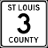
 County Road 3 (CSAH) begins at the intersection
of Becks Road and State Highway 23
in the city of Duluth
and continues north and west in Midway Township
, just past the intersection of Becks Road and Carlton County Road 61
where Becks Road becomes Stenman Road, and terminates at the county line. It is 5 miles (8 km) in length.
County Road 3 is more commonly known as Becks Road in the Duluth
area and serves as a truck route. The axle weight limit on this route is 10 short tons (9 t).
 County Road 4 (CSAH) (sometimes referred to as Highway 4 or County 4), begins at the intersection of Central Entrance (MN 194
) and Rice Lake Road in Duluth
and continues north to its northern terminus at Biwabik
in the Iron Range
region of Minnesota. This route is known as Rice Lake Road in the city of Duluth, Rice Lake Township, and Gnesen Township; and known as the historic Vermilion Trail from the Island Lake
area (north of Duluth) to Biwabik. It is also officially designated Governor Rudy Perpich
Memorial Drive.
County 4 is 60 miles (96.6 km) in length and passes through the communities of:
County 4 serves as a north–south route between Duluth and Biwabik, and passes through the Cloquet Valley State Forest
.
The southern terminus of County 4 is the intersection of Rice Lake Road and State Highway 194
(Central Entrance) in Duluth
. The northern terminus of County 4 is the intersection of Vermilion Trail and State Highway 135
in Biwabik
.
 County Road 5 (CSAH) (sometimes referred to as Highway 5 or County 5), begins at the intersection of County 5 and County 8 in Arrowhead Township and continues north to its northern terminus at the intersection of County 5 and West Olson Road (CR 114) near the St. Louis
/ Itasca
county line (west of Cook
). The section of County 5 in Ness Township, south of Meadowlands
, is unpaved gravel
surface.
County 5 passes through the communities of:
McCarthy Beach State Park
is located on the route.
 County Road 6 (CSAH) begins at the intersection of U.S. Highway 53
and Maple Grove Road in the city of Duluth
and continues west to its western terminus in Brevator Township at the intersection of Maple Grove Road and State Highway 33
. It is 13 miles (20.9 km) in length and passes through the communities of Duluth
, Hermantown
, Solway Township, and Brevator Township.
County Road 6 is more commonly known as Maple Grove Road in the Duluth
area.
Maple Grove Road serves as an east–west arterial route between U.S. Highway 53, Haines Road (CR 91), Lavaque Road (CR 48), Midway Road (CR 13), U.S. Highway 2
, and State Highway 33
.
 County Road 7 (CSAH) (sometimes referred to as Highway 7 or County 7), begins at the intersection
of U.S. Highway 53
and Industrial Road in Grand Lake Township and continues north to its northern terminus at the city of Mountain Iron
in the Mesabi Range
region. County 7 is also known as Industrial Road in Grand Lake Township and Industrial Township. This route is also officially designated the Bobby Aro Memorial Highway. Aro was an Iron Range radio personality and entertainer. County 7 is 52 miles (83.7 km) in length and passes through the communities of:
County 7 serves as primarily a north–south route for most of its length. It changes direction to east–west as it approaches Industrial Township and continues as east–west to its terminus at U.S. Highway 53 in the community of Twig
in Grand Lake Township. County 7 parallels U.S. Highway 53 for much of its route, and crosses the St. Louis River
near Forbes
, the Whiteface River in Kelsey Township, and the Cloquet River in Industrial Township.
 County Road 8 (CSAH) begins at the intersection of State Highway 73
and County 8 in Floodwood
and continues east to its eastern terminus at the intersection of U.S. Highway 53
and County 8 in Grand Lake Township near Twig
. County 8 serves as a direct route between Floodwood and U.S. Highway 53. County 8 also has an intersection with State Highway 33
in Industrial Township near Independence
. The majority of the route is unpaved gravel
surface.
 County Road 9 (CSAH) is 11 miles (17.7 km) in length and passes through the communities of Canosia Township and Rice Lake Township before entering the city of Duluth. County Road 9 begins at the intersection of U.S. Highway 53
with Caribou Lake Road, heads northbound on Caribou Lake Road for 0.7 miles (1.1 km), heads eastbound on North Pike Lake Road for 2 miles (3.2 km), and southbound for 0.5 mile (0.80467 km) on Midway Road to its intersection with Martin Road; this non-arterial route was originally an extension to the arterial portion of County Road 9. The arterial section of County Road 9 begins at the intersection of Martin Road and Midway Road (CR 13) in Canosia Township and continues eastbound along Martin Road to the intersection of Arnold Road (CR 34) with Martin Road (CR 10). Martin Road serves as an east–west arterial route between Midway Road and Jean Duluth Road (CR 37) on the northern edge of Duluth, and serves as a truck route. The axle weight limit on this route is 9 short tons (8 t). Turning onto Arnold Road, County Road 9 heads southbound for 0.7 miles (1.1 km), enters the city of Duluth
as it heads southeast onto Calvary Road, heads south on Woodland Avenue for approximately 2.3 miles (3.7 km), briefly head east on East Arrowhead Road, continues south on Wallace Avenue for approximately 0.6 mile (0.965604 km), then southwest (west, in Duluth Coordinates) on East 4th Street for 2 miles (3.2 km) before terminating at the intersection with 6th Avenue East. The portion of County Road 9 from Woodland Avenue to East 4th Street; and from East 4th Street to 6th Avenue East is an unmarked county route within the city of Duluth.
County Road 10 (CSAH) begins at the intersection of Arnold Road (CR 9 and CR 36) and Martin Road (CR 9) in Rice Lake Township and continues the east–west arterial route served by County Road 9 eastbound to Jean Duluth Road (CR 37). This western segment of County Road 10 is 3.2 miles (5 km) in length. The eastern segment of County Road 10 begins at the intersection of Jean Duluth Road (CR 37) and West Tischer Road (CR 2), 1.2 miles (1.9 km) north of where the western segment of County Road 10 terminates. The eastern segment of County Road 10 heads eastbound on West Tischer Road in Lakewood Township
for 2 miles (3.2 km), heads northbound on North Tischer Road for 0.5 mile (0.80467 km), then heads eastbound on Strand Road for 1 miles (1.6 km), terminating at Lester River Road (CR 12).
County Road 11 (CSAH) is 3.4 miles (5.5 km) long. It begins at the intersection of Midway Road (CR 13) and Stark Road (CR 894) in Midway Township
, heads eastbound on Stark Road, briefly heads southbound on Ugstad Road, heads eastbound through the city of Proctor
on 4th Street, heads southbound on 5th Avenue North, then heads eastbound on 2nd Street, and terminates at Boundary Avenue (CR 14).
County Road 12 (CSAH) begins at the intersection of 60th Avenue East and East Superior Street in the Lakeside – Lester Park neighborhood of Duluth
, heads eastbound on East Superior Street to 61st Avenue East, heads northbound on Lester River Road for 6.45 miles (10.4 km), heads eastbound on Roberg Road for 1 miles (1.6 km), heads northbound on Lakewood Road for 0.75 miles (1.2 km), and terminates at Lismore Road (CR 43) in Lakewood Township
. The one block portion of County Road 12 following East Superior Street from 60th Avenue East to 61st Avenue East / Lester River Road is an unmarked county route within the city of Duluth.
 County Road 13 (CSAH) begins at the intersection of Midway Road and Becks Road (CR 3) in Midway Township
and continues north to its northern terminus in Canosia Township / Pike Lake at the intersection of Midway Road and Martin Road (CR 9).
County Road 13 is 11 miles (17.7 km) in length and passes through the communities of Midway Township
, the city of Hermantown
, and Canosia Township.
County Road 13 is also known as Midway Road in the Duluth
area and serves as a truck route. Midway Road serves as a key north–south arterial route along Duluth's western outskirts. The axle weight limit on this route is 10 short tons (9 t). Midway Road carries approximately 9,000 vehicles per day as of 2011.
The southern terminus of County Road 13 is near its interchange with Interstate Highway 35
in Midway Township. Its northern terminus is near its intersection with U.S. Highway 53
in the Pike Lake district of Canosia Township.
County Road 14 (CSAH) begins at the intersection of Midway Road (CR 13) and Thompson Hill Road in Midway Township
, heads northeast on Thompson Hill Road / Mountain Drive while paralleling on the south side of Interstate Highway 35
, briefly turns onto Skyline Parkway, then heads northbound on Boundary Avenue that divides Duluth
from Proctor
, then heads westbound on 5th Street in Proctor, terminating at its intersection with U.S. Highway 2
.
County Road 15 (CSAH) begins at the intersection of Munger Shaw Road and U.S. Highway 53
in Grand Lake Township. The southern segment of County Road 15 heads northbound on Munger Shaw Road and terminates at the intersection of Taft Road (CR 48) and Munger Shaw Road (CR 223), located immediately south of Taft
. The northern segment of County Road 15 begins at the intersection of Munger Shaw Road (CR 223) with Three Lakes Road (CR 49), heads northbound into Shaw
, and terminates at its intersection with Comstock Lake Road (CR 52 and CR 547) located immediately east of Whiteface
.
 County Road 16 (CSAH) begins at the county line with Itasca County
near Bengal
(immediately southwest of Hibbing
and near State Highway 73
) and continues east to its eastern terminus at the county line with Lake County
near Fairbanks
.
County Road 16 is 64 miles (103 km) in length and passes through the communities of Bengal
, Forbes
, Peary
, Makinen
, Fairbanks
, and Bassett
. It serves as an east–west route between Fairbanks and the Hibbing area, and is also known as Townline Road and Wilson Road at various points throughout its route.
County 16 parallels State Highway 37
for part of its route.
County Road 17 (CSAH) is a short service route to the Duluth International Airport
and the Federal Prison Camp located next to the airport. The route begins at the intersection of Arrowhead Road (CR 32) and Airbase Road, heads northwest along Airbase Road, then heads southbound on Airport Approach Road and Stebner Road, and terminates at the intersection of Miller Trunk Highway (U.S. Highway 53
) and Stebner Road.
County Road 20 (CSAH) begins at Vermilion Trail (CR 4), near Bass Lake south of McKinley
, heads west and north into McKinley, and terminates at its intersection with Main Street.
, Morse Township
, and Ely
. The route begins at its intersection with State Highway 169
, near where State Highway 169 crosses Pike River
, heads east and north for 40 miles (64.4 km), enters Ely on Central Avenue, and terminates at its intersection with Sheridan Street (MN 169
/ MN 1
).
County Road 22 (CSAH) is a route in the northern portion of the county, serving Bear River
, Morcom Township, Sturgeon Township, Alango Township, and Sherman Corner
. The route begins in Bear River as Itasca County Road 22 becomes St. Louis County Road 22, heads east for approximately 20 miles (32.2 km) and terminates in Sherman Corner at the county road's intersection with U.S. Highway 53
and State Highway 1
. Until 1996, Itasca and St. Louis County Roads 22 were State Highway 1 and State Highway 1 located 6 miles (9.7 km) north paralleling the county roads was the Itasca and St. Louis County Roads 22.
County Road 23 (CSAH) is a route in the northern portion of the county, serving Nett Lake
, the Nett Lake Indian Reservation, Orr
, Leiding Township, Portage Township, and Buyck
. The 35.7 miles (57.5 km) route begins on Nett Lake Road in Nett Lake, heads east out of the Indian Reservation to Glendale
, heads concurrently
north with U.S. Highway 53
(Johnson Parkway) into Orr, heads east on Orr-Buyck Road out of Orr, and terminates at its intersection with Crane Lake Road (CR 24) in Buyck. The portion of County Road 23 within the Nett Lake Indian Reservation was formerly designated as County Road 793.
County Road 24 (CSAH) is a route in the northern portion of the county, serving Cook
, Owens Township, Beatty Township, Portage Township, Buyck
, and Crane Lake
. The 43.4 miles (69.8 km) route begins at the intersection on U.S. Highway 53
and 2nd Street Southeast in Cook, heads north on 2nd Street Southeast, briefly heads east on Vermilion Drive, then continues north on Vermilion Drive, heads out of Cook and generally continues to head north and east on Vermilion Road, heads east on Kallo Road, heads north on Crane Lake Road, and terminates along Gold Coast Road in Crane Lake. The central portion of the route is unpaved gravel surface from Buyck
southbound towards Wakemup
.
 County Road 25 (CSAH) is a route in the western portion of the county, serving McDavitt Township, Lavell Township, Clinton Township
, Cherry Township, Cherry
, Great Scott Township, Kinney
, Alango Township, Field Township, and Cook
; it also serves portions of the Superior National Forest
. The route begins at the intersection of Zim Road (CR 27) and Fraser Road near Zim
, generally heads north for 47.3 miles (76.1 km) into Cook, and terminates on Vermilion Drive at its intersection with 2nd Street Southeast (CR 24). County 25 also passes near Buhl
and Chisholm
.
County Road 26 (CSAH) is a route in the northern portion of the county, serving Embarrass Township, Kugler Township, Wahlsten, and Vermilion Lake Township. The 11.6 miles (18.7 km) route begins at the intersection of County Road 27 and Wahlsten Road near Embarrass, generally heads north and west through Wahlsten, and terminates at its intersection with State Highway 169
.
County Road 27 (CSAH) is a route in the northern portion of the county, serving Hibbing
, Lavell Township, McDavitt Township, and Zim
. The 10 miles (16.1 km) route begins at the intersection of County Road 5 and Zim Road near the southeastern corner of Hibbing, generally heads east on Zim Road to Zim, and terminates at its intersection with County Road 7.
County Road 28 (CSAH) is a route in the southwestern portion of the county, serving Sax
, McDavitt Township, and Lavell Township. The route begins at its intersection with County Road 7 in Sax, heads west 3.7 miles (6 km) on Sax Road, heads north 0.5 mile (0.80467 km) on Dass Road, heads west 2 miles (3.2 km) and terminates at its intersection with Overton Road (CR 83).
County Road 29 (CSAH) is a route in the southwestern portion of the county, serving Van Buren Township, Ness Township, Meadowlands Township, Meadowlands
, Toivola Township, and Kelsey Township. The 26 miles (41.8 km) route begins 1 miles (1.6 km) north of Floodwood
at its intersection with State Highway 73
, heads east and north through Meadowlands and terminates 0.5 mile (0.80467 km) south of Kelsey
at its intersection with County Road 7.
 County Road 32 begins at the intersection of U.S. Highway 53
and Arrowhead Road in Hermantown
and continues east to its eastern terminus at the intersection of Arrowhead Road and Arlington Avenue (CR 90) in Duluth
.
County Road 32 is 2.5 miles (4 km) in length and passes through the communities of Hermantown
and Duluth
.
County Road 32 is known as Arrowhead Road in the Duluth
area. Arrowhead Road serves as an east–west arterial route between Hermantown, the Miller Hill area of Duluth, and eastern Duluth. Arrowhead Road in Duluth and Hermantown is actually 9 miles (14.5 km) in length; however, only 2.5 miles is designated and signed as County Road 32.
 County Road 37 begins at the intersection of Glenwood Street and Jean Duluth Road in the city of Duluth
and continues north to its northern terminus at Normanna Road (CR 44) in Normanna Township.
County Road 37 is more commonly known as Jean Duluth Road in the Duluth
area and passes through the communities of Lakewood Township
, Normanna Township, and the city of Duluth
.
Jean Duluth Road serves as a north–south arterial route between Glenwood Street, Martin Road (CR 9/CR 10), and Normanna Road.
 County Road 48 is more commonly known as Lavaque Road in the Duluth
area and serves as a north–south arterial route. It is 15 miles (24.1 km) in length and passes through the communities of Proctor
, Hermantown
, Canosia Township, and Fredenberg Township.
The first section of County Road 48 runs from the intersection of Second Avenue (Lavaque Road) and U.S. Highway 2
in the city of Proctor
and continues north to the intersection of Lavaque Road and U.S. Highway 53
in the city of Hermantown
. The second section runs from the intersection of Lavaque Bypass Road and U.S. Highway 53 in the city of Hermantown and continues north to the intersection of Lavaque Road and Fish Lake Road in Fredenberg Township. The third section of County 48 is a non-arterial 4 miles (6.4 km) route following Fish Lake Road and Taft Road.
The southern terminus of County Road 48 is the intersection of Second Avenue and U.S. Highway 2
in the city of Proctor
. The northern terminus is at the intersection of Taft Road and County Road 15 in the community of Taft
in Grand Lake Township.
 County Road 49 runs from the intersection of County 49 and U.S. Highway 53
in Northland Township
(near Canyon
) and continues east to its eastern terminus at the intersection of County Road 49 and County Road 4 (near Island Lake
). County Road 49 passes through the Three Lakes Area and the community of Shaw
. County 49 is also known as Three Lakes Road. The majority of the route is unpaved gravel surface.
 County Road 52 runs from the intersection of County Road 52 and County Road 5 in Toivola
and continues east to its eastern terminus at the intersection of County Road 52 / County Road 15 / County Road 547 near Whiteface
and Shaw
.
County Road 52 is known as Arkola Road between Toivola and its intersection with U.S. Highway 53
at Cotton
. County Road 52 is also known as Comstock Lake Road between Cotton and its eastern terminus near Shaw.
 County Road 56 runs from the intersection of Morris Thomas Road and Piedmont Avenue in the city of Duluth
and continues west to its western terminus in Brevator Township at the intersection of Morris Thomas Road and State Highway 33
.
County Road 56 is 14 miles (22.5 km) in length and passes through the communities of Duluth
, Hermantown
, Solway Township, and Brevator Township. This route is more commonly known as Morris Thomas Road in the Duluth
area.
Morris Thomas Road serves as an east–west arterial route between Piedmont Avenue, Haines Road (CR 91), Lavaque Road (CR 48), U.S. Highway 2
, Midway Road (CR 13), and State Highway 33
.
County Road 58 runs from State Highway 169
near Winton
and continues southeasterly to the St. Louis / Lake County Line. This segment of roadway is also known as the Kawishiwi Trail.
 County Road 61 runs from the intersection
of Congdon Boulevard and the Minnesota 61 Expressway
near Brighton Beach in Duluth, Minnesota
and follows the North Shore Scenic Drive to Two Harbors
.
County Road 61 passes through the communities of Duluth Township (French River
and Palmers
) and the city of Duluth
. It is more commonly known and signed as North Shore Scenic Drive between Duluth and Two Harbors. This stretch of County Road 61 is also known as Scenic 61.
Between Duluth and Two Harbors, what is now County Road 61 was commissioned as U.S. Highway 61
in 1926, ready for use by 1929, and paved by 1940. Until the expressway
between Duluth and Two Harbors was constructed inland in the 1960s, County Road 61 (then U.S. 61) had served as the principal route between Duluth and Two Harbors. The state turned over management of the road to St. Louis
and Lake
Counties in the 1960s, and the two counties then designated this route County Road 61.
The course for Grandma's Marathon
follows this road route annually in June.
County Road 69. See County Road 2.
 County Road 90 runs from the intersection of U.S. Highway 53
and Arlington Avenue in Duluth
and continues north to its northern terminus at the intersection of Arlington Avenue and Arrowhead Road (CR 32) in Duluth
.
County Road 90 is 3 miles (4.8 km) in length and is an arterial route in the Duluth Heights
neighborhood of Duluth
. This route is known as Arlington Avenue in Duluth.
 County Road 91 runs from the intersection of 40th Avenue West and West 8th Street in Duluth
and continues north to its northern terminus at the intersection of Haines Road and Airport Road in Duluth
.
County Road 91 is 6 miles (9.7 km) in length and passes through the communities of Duluth
and Hermantown
. The road actually serves as a boundary line between the two cities for much of its length.
County Road 91 is more commonly known as Haines Road in the Duluth
area and serves as an arterial route. A small section of County Road 91 is known as 40th Avenue West.
Haines Road serves as an arterial route between West Duluth
, Hermantown
, and the Miller Hill area of Duluth
.
 County Road 92 runs from the intersection of County 92 / U.S. 169
/ State Highway 73
in Hibbing
and continues east to its eastern terminus at the intersection of County 92 and County 25 in Cherry
.
 County Road 93 runs from the intersection of County 93 and U.S. Highway 53
at Central Lakes
and continues east to its eastern terminus at the intersection of County 93 and County 16 in Makinen
.
County 93 is sometimes used as a shortcut between U.S. 53 at Central Lakes and County 16 at Makinen to reach Palo
and Aurora
(via County 16 and County 100).
 County Road 100 runs from the intersection of County 100 and County Road 4 near Makinen
and Palo
and continues north to its northern terminus at the intersection of County 100 and State Highway 135
in Aurora
. County 100 passes through Palo.
, and its eastern terminus is at its intersection with County Road 16 near Fairbanks
.
and passes through the unincorporated area of Britt
. It is a bypass route to Britt and a shortcut to Wuori Township. The "L" shaped route of CR 303 follows Trillium Road, Rice River Road and Hill Road; and passes through Wuori Township, Sandy Township, and briefly enters Pike Township
, where it meets again with State Highway 169.
County Road 793. See County Road 23.
County highway
A county highway is a road in the United States and in the Canadian province of Ontario that is designated and/or maintained by the county highway department...
in St. Louis County
St. Louis County, Minnesota
St. Louis County is a county located in the U.S. state of Minnesota. As of 2010, the population was 200,226. Its county seat is Duluth. It is the largest county by total area in Minnesota, and the second largest in the United States east of the Mississippi River; in land area alone, after Aroostook...
, Minnesota
Minnesota
Minnesota is a U.S. state located in the Midwestern United States. The twelfth largest state of the U.S., it is the twenty-first most populous, with 5.3 million residents. Minnesota was carved out of the eastern half of the Minnesota Territory and admitted to the Union as the thirty-second state...
, United States
United States
The United States of America is a federal constitutional republic comprising fifty states and a federal district...
.
CR 1–CR 20
County Road 2 (CSAH) begins at the intersection of Rice Lake Road (CR 4) with West Tischer Road, heads eastbound through Rice Lake Township on West Tischer Road, and terminates at the intersection of West Tischer Road with Jean Duluth Road (CR 37). It is 5 miles (8 km) in length. County Road 2 was previously designated as County Road 69.Intersection (road)
An intersection is a road junction where two or more roads either meet or cross at grade . An intersection may be 3-way - a T junction or fork, 4-way - a crossroads, or 5-way or more...
of Becks Road and State Highway 23
Minnesota State Highway 23
Minnesota State Highway 23 is a state highway that stretches from southwest to northeast Minnesota. At in length, it is the second longest state route in Minnesota, after MN 1....
in the city of Duluth
Duluth, Minnesota
Duluth is a port city in the U.S. state of Minnesota and is the county seat of Saint Louis County. The fourth largest city in Minnesota, Duluth had a total population of 86,265 in the 2010 census. Duluth is also the second largest city that is located on Lake Superior after Thunder Bay, Ontario,...
and continues north and west in Midway Township
Midway Township, St. Louis County, Minnesota
Midway Township is a township in Saint Louis County, Minnesota, United States. The population was 1,399 at the 2010 census.Midway Road, Becks Road, and Interstate Highway 35 are three of the main arterial routes in the township.-Geography:...
, just past the intersection of Becks Road and Carlton County Road 61
Carlton County, Minnesota
As of the census of 2000, there were 31,671 people, 12,064 households, and 8,408 families residing in the county. The population density was 37 people per square mile . There were 13,721 housing units at an average density of 16 per square mile...
where Becks Road becomes Stenman Road, and terminates at the county line. It is 5 miles (8 km) in length.
County Road 3 is more commonly known as Becks Road in the Duluth
Duluth, Minnesota
Duluth is a port city in the U.S. state of Minnesota and is the county seat of Saint Louis County. The fourth largest city in Minnesota, Duluth had a total population of 86,265 in the 2010 census. Duluth is also the second largest city that is located on Lake Superior after Thunder Bay, Ontario,...
area and serves as a truck route. The axle weight limit on this route is 10 short tons (9 t).
Minnesota State Highway 194
Minnesota State Highway 194 is a highway in northeast Minnesota, which runs from its intersection with U.S. Highway 2 in Solway Township and continues east to its eastern terminus at its Mesaba Avenue interchange with Interstate Highway 35 in downtown Duluth. For part of its route, it runs...
) and Rice Lake Road in Duluth
Duluth, Minnesota
Duluth is a port city in the U.S. state of Minnesota and is the county seat of Saint Louis County. The fourth largest city in Minnesota, Duluth had a total population of 86,265 in the 2010 census. Duluth is also the second largest city that is located on Lake Superior after Thunder Bay, Ontario,...
and continues north to its northern terminus at Biwabik
Biwabik, Minnesota
Biwabik is a city in Saint Louis County, Minnesota, United States. The population was 969 at the 2010 census.Minnesota State Highway 135 and Vermilion Trail are two of the main routes in the city....
in the Iron Range
Iron Range
The Iron Range is a region that makes up the northeastern section of Minnesota in the United States. "The Range", as it is known by locals, is a region with multiple distinct bands of iron ore...
region of Minnesota. This route is known as Rice Lake Road in the city of Duluth, Rice Lake Township, and Gnesen Township; and known as the historic Vermilion Trail from the Island Lake
Island Lake, Minnesota
Island Lake is an unincorporated community in Saint Louis County, Minnesota, United States.The community is located 18 miles north of the city of Duluth on County Road 4 .Island Lake is located within Gnesen Township and Fredenberg Township....
area (north of Duluth) to Biwabik. It is also officially designated Governor Rudy Perpich
Rudy Perpich
Rudolph George "Rudy" Perpich, Sr. was an American politician and the longest-serving governor of Minnesota. A member of the Democratic-Farmer-Labor Party, he served as the 34th and 36th Governor of Minnesota from December 29, 1976 to January 4, 1979, and from January 3, 1983, to January 7, 1991...
Memorial Drive.
County 4 is 60 miles (96.6 km) in length and passes through the communities of:
|
Biwabik, Minnesota Biwabik is a city in Saint Louis County, Minnesota, United States. The population was 969 at the 2010 census.Minnesota State Highway 135 and Vermilion Trail are two of the main routes in the city.... |
County 4 serves as a north–south route between Duluth and Biwabik, and passes through the Cloquet Valley State Forest
Cloquet Valley State Forest
The Cloquet Valley State Forest encompasses ; of which are Minnesota Department of Natural Resources forestry administered lands.Located in southeast St. Louis County, the Cloquet Valley State Forest is located about north of Duluth and southeast of Virginia, in Minnesota's Arrowhead region. ...
.
The southern terminus of County 4 is the intersection of Rice Lake Road and State Highway 194
Minnesota State Highway 194
Minnesota State Highway 194 is a highway in northeast Minnesota, which runs from its intersection with U.S. Highway 2 in Solway Township and continues east to its eastern terminus at its Mesaba Avenue interchange with Interstate Highway 35 in downtown Duluth. For part of its route, it runs...
(Central Entrance) in Duluth
Duluth, Minnesota
Duluth is a port city in the U.S. state of Minnesota and is the county seat of Saint Louis County. The fourth largest city in Minnesota, Duluth had a total population of 86,265 in the 2010 census. Duluth is also the second largest city that is located on Lake Superior after Thunder Bay, Ontario,...
. The northern terminus of County 4 is the intersection of Vermilion Trail and State Highway 135
Minnesota State Highway 135
Minnesota State Highway 135 is a highway in northeast Minnesota, which runs from its interchange with U.S. Highway 53 in the city of Virginia and continues northeast to its northern terminus at its intersection with State Highway 1 in Tower....
in Biwabik
Biwabik, Minnesota
Biwabik is a city in Saint Louis County, Minnesota, United States. The population was 969 at the 2010 census.Minnesota State Highway 135 and Vermilion Trail are two of the main routes in the city....
.
St. Louis County, Minnesota
St. Louis County is a county located in the U.S. state of Minnesota. As of 2010, the population was 200,226. Its county seat is Duluth. It is the largest county by total area in Minnesota, and the second largest in the United States east of the Mississippi River; in land area alone, after Aroostook...
/ Itasca
Itasca County, Minnesota
Itasca County is a county located in the U.S. state of Minnesota. It is named after Lake Itasca, which is in turn a shortened version the Latin words veritas caput, meaning 'truth' and 'head', a reference to the source of the Mississippi River. As of 2010, the population was 45,058. Its county seat...
county line (west of Cook
Cook, Minnesota
Cook is a city in Saint Louis County, Minnesota, United States. The population was 574 at the 2010 census.U.S. Highway 53 and Minnesota Highway 1 are two of the main arterial routes in the community....
). The section of County 5 in Ness Township, south of Meadowlands
Meadowlands, Minnesota
Meadowlands is a city in Saint Louis County, Minnesota, United States. The population was 134 at the 2010 census.County Highway 133 and County Highway 5 are two of the main arterial routes in the community.-History:...
, is unpaved gravel
Gravel road
A gravel road is a type of unpaved road surfaced with gravel that has been brought to the site from a quarry or stream bed. They are common in less-developed nations, and also in the rural areas of developed nations such as Canada and the United States. In New Zealand, they are known as 'metal roads'...
surface.
County 5 passes through the communities of:
|
Hibbing, Minnesota Hibbing is a city in Saint Louis County, Minnesota, United States. The population was 16,361 at the 2010 census. The city was built on the rich iron ore of the Mesabi Iron Range. At the edge of town is the largest open-pit iron mine in the world. U.S... Side Lake, Minnesota Side Lake is an unincorporated community in French Township, Saint Louis County, Minnesota, United States.The community is located north of the cities of Chisholm and Hibbing on County Highway 5.McCarthy Beach State Park is nearby.-References:... |
McCarthy Beach State Park
McCarthy Beach State Park
McCarthy Beach State Park is a state park of Minnesota, USA, on the Sturgeon Lake chain near Hibbing. It is located in French Township, St. Louis County, Minnesota.-Ecosystem:...
is located on the route.
U.S. Route 53
U.S. Route 53 is a north–south U.S. highway that runs for 403 miles from La Crosse, Wisconsin to northern Minnesota. It is the primary north–south route in northwestern Wisconsin, serving as a vital link between I-94 at Eau Claire, Wisconsin and the city of Duluth, Minnesota...
and Maple Grove Road in the city of Duluth
Duluth, Minnesota
Duluth is a port city in the U.S. state of Minnesota and is the county seat of Saint Louis County. The fourth largest city in Minnesota, Duluth had a total population of 86,265 in the 2010 census. Duluth is also the second largest city that is located on Lake Superior after Thunder Bay, Ontario,...
and continues west to its western terminus in Brevator Township at the intersection of Maple Grove Road and State Highway 33
Minnesota State Highway 33
Minnesota State Highway 33 is a highway in northeast Minnesota, which runs from its interchange with Interstate 35 at Cloquet and continues north to its northern terminus at its interchange with U.S. Highway 53 at Independence...
. It is 13 miles (20.9 km) in length and passes through the communities of Duluth
Duluth, Minnesota
Duluth is a port city in the U.S. state of Minnesota and is the county seat of Saint Louis County. The fourth largest city in Minnesota, Duluth had a total population of 86,265 in the 2010 census. Duluth is also the second largest city that is located on Lake Superior after Thunder Bay, Ontario,...
, Hermantown
Hermantown, Minnesota
As of the census of 2000, there were 7,448 people, 2,726 households, and 2,077 families residing in the city. The population density was 216.9 people per square mile . There were 2,822 housing units at an average density of 82.2 per square mile...
, Solway Township, and Brevator Township.
County Road 6 is more commonly known as Maple Grove Road in the Duluth
Duluth, Minnesota
Duluth is a port city in the U.S. state of Minnesota and is the county seat of Saint Louis County. The fourth largest city in Minnesota, Duluth had a total population of 86,265 in the 2010 census. Duluth is also the second largest city that is located on Lake Superior after Thunder Bay, Ontario,...
area.
Maple Grove Road serves as an east–west arterial route between U.S. Highway 53, Haines Road (CR 91), Lavaque Road (CR 48), Midway Road (CR 13), U.S. Highway 2
U.S. Route 2 in Minnesota
U.S. Highway 2 is a highway in northwest and northeast Minnesota, which runs from the Red River at East Grand Forks and continues east to Duluth, where the route crosses the Richard I. Bong Memorial Bridge over the Saint Louis Bay. The route connects the cities of East Grand Forks, Bemidji, Grand...
, and State Highway 33
Minnesota State Highway 33
Minnesota State Highway 33 is a highway in northeast Minnesota, which runs from its interchange with Interstate 35 at Cloquet and continues north to its northern terminus at its interchange with U.S. Highway 53 at Independence...
.
Intersection (road)
An intersection is a road junction where two or more roads either meet or cross at grade . An intersection may be 3-way - a T junction or fork, 4-way - a crossroads, or 5-way or more...
of U.S. Highway 53
U.S. Route 53
U.S. Route 53 is a north–south U.S. highway that runs for 403 miles from La Crosse, Wisconsin to northern Minnesota. It is the primary north–south route in northwestern Wisconsin, serving as a vital link between I-94 at Eau Claire, Wisconsin and the city of Duluth, Minnesota...
and Industrial Road in Grand Lake Township and continues north to its northern terminus at the city of Mountain Iron
Mountain Iron, Minnesota
As of the census of 2000, there were 2,999 people, 1,326 households, and 847 families residing in the city. The population density was 60.7 people per square mile . There were 1,409 housing units at an average density of 28.5 per square mile...
in the Mesabi Range
Mesabi Range
The Mesabi Iron Range is a vast deposit of iron ore and the largest of four major iron ranges in the region collectively known as the Iron Range of Minnesota. Discovered in 1866, it is the chief deposit of iron ore in the United States. The deposit is located in northeast Minnesota, largely in...
region. County 7 is also known as Industrial Road in Grand Lake Township and Industrial Township. This route is also officially designated the Bobby Aro Memorial Highway. Aro was an Iron Range radio personality and entertainer. County 7 is 52 miles (83.7 km) in length and passes through the communities of:
|
Sax, Minnesota Sax is an unincorporated community in McDavitt Township, St. Louis County, Minnesota, United States.County Highway 7 serves as a main arterial route in the community.County Road 52 is nearby.-References:... Zim, Minnesota Zim is an unincorporated community in McDavitt Township, St. Louis County, Minnesota, United States.The community is located southwest of the city of Eveleth at the junction of County Highway 7 and County 27.-References:... Forbes, Minnesota Forbes is an unincorporated community in St. Louis County, Minnesota, United States.The community is located southwest of the city of Eveleth at the junction of County Highway 7 and County Highway 16... Clinton Township, St. Louis County, Minnesota Clinton Township is a township in St. Louis County, Minnesota, United States. The population was 1,015 at the 2010 census.State Highway 37 and County Highway 7 are two of the main arterial routes in the township.-Geography:... Iron Junction, Minnesota Iron Junction is a city in Saint Louis County, Minnesota, United States. The population was 86 at the 2010 census.County Highway 7 serves as a main arterial route in the community. State Highway 37 is nearby.... Mountain Iron, Minnesota As of the census of 2000, there were 2,999 people, 1,326 households, and 847 families residing in the city. The population density was 60.7 people per square mile . There were 1,409 housing units at an average density of 28.5 per square mile... |
County 7 serves as primarily a north–south route for most of its length. It changes direction to east–west as it approaches Industrial Township and continues as east–west to its terminus at U.S. Highway 53 in the community of Twig
Twig, Minnesota
Twig is an unincorporated community in Grand Lake Township, Saint Louis County, Minnesota, United States.The community is located 15 miles northwest of the city of Duluth at the junction of U.S...
in Grand Lake Township. County 7 parallels U.S. Highway 53 for much of its route, and crosses the St. Louis River
Saint Louis River
The St. Louis River is a river in the U.S. states of Minnesota and Wisconsin that flows into Lake Superior. The largest U.S. river to flow into the lake, it is 179 miles in length and starts near Hoyt Lakes, Minnesota. The river's watershed is in area...
near Forbes
Forbes, Minnesota
Forbes is an unincorporated community in St. Louis County, Minnesota, United States.The community is located southwest of the city of Eveleth at the junction of County Highway 7 and County Highway 16...
, the Whiteface River in Kelsey Township, and the Cloquet River in Industrial Township.
Minnesota State Highway 73
Minnesota State Highway 73 is a highway in northeast Minnesota, which runs from its interchange with Interstate Highway 35 in Moose Lake and continues north to its northern terminus at its intersection with U.S...
and County 8 in Floodwood
Floodwood, Minnesota
As of the census of 2000, there were 503 people , 254 households, and 112 families residing in the city. The population density was 1,131.9 people per square mile . There were 290 housing units at an average density of 652.6 per square mile...
and continues east to its eastern terminus at the intersection of U.S. Highway 53
U.S. Route 53
U.S. Route 53 is a north–south U.S. highway that runs for 403 miles from La Crosse, Wisconsin to northern Minnesota. It is the primary north–south route in northwestern Wisconsin, serving as a vital link between I-94 at Eau Claire, Wisconsin and the city of Duluth, Minnesota...
and County 8 in Grand Lake Township near Twig
Twig, Minnesota
Twig is an unincorporated community in Grand Lake Township, Saint Louis County, Minnesota, United States.The community is located 15 miles northwest of the city of Duluth at the junction of U.S...
. County 8 serves as a direct route between Floodwood and U.S. Highway 53. County 8 also has an intersection with State Highway 33
Minnesota State Highway 33
Minnesota State Highway 33 is a highway in northeast Minnesota, which runs from its interchange with Interstate 35 at Cloquet and continues north to its northern terminus at its interchange with U.S. Highway 53 at Independence...
in Industrial Township near Independence
Independence, St. Louis County, Minnesota
Independence is an unincorporated community in Saint Louis County, Minnesota, United States.The community is located 22 miles northwest of the city of Duluth at the junction of U.S...
. The majority of the route is unpaved gravel
Gravel road
A gravel road is a type of unpaved road surfaced with gravel that has been brought to the site from a quarry or stream bed. They are common in less-developed nations, and also in the rural areas of developed nations such as Canada and the United States. In New Zealand, they are known as 'metal roads'...
surface.
U.S. Route 53
U.S. Route 53 is a north–south U.S. highway that runs for 403 miles from La Crosse, Wisconsin to northern Minnesota. It is the primary north–south route in northwestern Wisconsin, serving as a vital link between I-94 at Eau Claire, Wisconsin and the city of Duluth, Minnesota...
with Caribou Lake Road, heads northbound on Caribou Lake Road for 0.7 miles (1.1 km), heads eastbound on North Pike Lake Road for 2 miles (3.2 km), and southbound for 0.5 mile (0.80467 km) on Midway Road to its intersection with Martin Road; this non-arterial route was originally an extension to the arterial portion of County Road 9. The arterial section of County Road 9 begins at the intersection of Martin Road and Midway Road (CR 13) in Canosia Township and continues eastbound along Martin Road to the intersection of Arnold Road (CR 34) with Martin Road (CR 10). Martin Road serves as an east–west arterial route between Midway Road and Jean Duluth Road (CR 37) on the northern edge of Duluth, and serves as a truck route. The axle weight limit on this route is 9 short tons (8 t). Turning onto Arnold Road, County Road 9 heads southbound for 0.7 miles (1.1 km), enters the city of Duluth
Duluth, Minnesota
Duluth is a port city in the U.S. state of Minnesota and is the county seat of Saint Louis County. The fourth largest city in Minnesota, Duluth had a total population of 86,265 in the 2010 census. Duluth is also the second largest city that is located on Lake Superior after Thunder Bay, Ontario,...
as it heads southeast onto Calvary Road, heads south on Woodland Avenue for approximately 2.3 miles (3.7 km), briefly head east on East Arrowhead Road, continues south on Wallace Avenue for approximately 0.6 mile (0.965604 km), then southwest (west, in Duluth Coordinates) on East 4th Street for 2 miles (3.2 km) before terminating at the intersection with 6th Avenue East. The portion of County Road 9 from Woodland Avenue to East 4th Street; and from East 4th Street to 6th Avenue East is an unmarked county route within the city of Duluth.
County Road 10 (CSAH) begins at the intersection of Arnold Road (CR 9 and CR 36) and Martin Road (CR 9) in Rice Lake Township and continues the east–west arterial route served by County Road 9 eastbound to Jean Duluth Road (CR 37). This western segment of County Road 10 is 3.2 miles (5 km) in length. The eastern segment of County Road 10 begins at the intersection of Jean Duluth Road (CR 37) and West Tischer Road (CR 2), 1.2 miles (1.9 km) north of where the western segment of County Road 10 terminates. The eastern segment of County Road 10 heads eastbound on West Tischer Road in Lakewood Township
Lakewood Township, St. Louis County, Minnesota
Lakewood Township is a township in Saint Louis County, Minnesota, United States. The population was 2,190 as recorded at the 2010 census.Jean Duluth Road, West Tischer Road, North Tischer Road, Lakewood Road, and Strand Road are five of the main arterial routes in the township.-Geography:According...
for 2 miles (3.2 km), heads northbound on North Tischer Road for 0.5 mile (0.80467 km), then heads eastbound on Strand Road for 1 miles (1.6 km), terminating at Lester River Road (CR 12).
County Road 11 (CSAH) is 3.4 miles (5.5 km) long. It begins at the intersection of Midway Road (CR 13) and Stark Road (CR 894) in Midway Township
Midway Township, St. Louis County, Minnesota
Midway Township is a township in Saint Louis County, Minnesota, United States. The population was 1,399 at the 2010 census.Midway Road, Becks Road, and Interstate Highway 35 are three of the main arterial routes in the township.-Geography:...
, heads eastbound on Stark Road, briefly heads southbound on Ugstad Road, heads eastbound through the city of Proctor
Proctor, Minnesota
As of the census of 2000, there were 2,852 people, 1,196 households, and 772 families residing in the city. The population density was 942.8 people per square mile . There were 1,246 housing units at an average density of 411.9 per square mile...
on 4th Street, heads southbound on 5th Avenue North, then heads eastbound on 2nd Street, and terminates at Boundary Avenue (CR 14).
County Road 12 (CSAH) begins at the intersection of 60th Avenue East and East Superior Street in the Lakeside – Lester Park neighborhood of Duluth
Duluth, Minnesota
Duluth is a port city in the U.S. state of Minnesota and is the county seat of Saint Louis County. The fourth largest city in Minnesota, Duluth had a total population of 86,265 in the 2010 census. Duluth is also the second largest city that is located on Lake Superior after Thunder Bay, Ontario,...
, heads eastbound on East Superior Street to 61st Avenue East, heads northbound on Lester River Road for 6.45 miles (10.4 km), heads eastbound on Roberg Road for 1 miles (1.6 km), heads northbound on Lakewood Road for 0.75 miles (1.2 km), and terminates at Lismore Road (CR 43) in Lakewood Township
Lakewood Township, St. Louis County, Minnesota
Lakewood Township is a township in Saint Louis County, Minnesota, United States. The population was 2,190 as recorded at the 2010 census.Jean Duluth Road, West Tischer Road, North Tischer Road, Lakewood Road, and Strand Road are five of the main arterial routes in the township.-Geography:According...
. The one block portion of County Road 12 following East Superior Street from 60th Avenue East to 61st Avenue East / Lester River Road is an unmarked county route within the city of Duluth.
Midway Township, St. Louis County, Minnesota
Midway Township is a township in Saint Louis County, Minnesota, United States. The population was 1,399 at the 2010 census.Midway Road, Becks Road, and Interstate Highway 35 are three of the main arterial routes in the township.-Geography:...
and continues north to its northern terminus in Canosia Township / Pike Lake at the intersection of Midway Road and Martin Road (CR 9).
County Road 13 is 11 miles (17.7 km) in length and passes through the communities of Midway Township
Midway Township, St. Louis County, Minnesota
Midway Township is a township in Saint Louis County, Minnesota, United States. The population was 1,399 at the 2010 census.Midway Road, Becks Road, and Interstate Highway 35 are three of the main arterial routes in the township.-Geography:...
, the city of Hermantown
Hermantown, Minnesota
As of the census of 2000, there were 7,448 people, 2,726 households, and 2,077 families residing in the city. The population density was 216.9 people per square mile . There were 2,822 housing units at an average density of 82.2 per square mile...
, and Canosia Township.
County Road 13 is also known as Midway Road in the Duluth
Duluth, Minnesota
Duluth is a port city in the U.S. state of Minnesota and is the county seat of Saint Louis County. The fourth largest city in Minnesota, Duluth had a total population of 86,265 in the 2010 census. Duluth is also the second largest city that is located on Lake Superior after Thunder Bay, Ontario,...
area and serves as a truck route. Midway Road serves as a key north–south arterial route along Duluth's western outskirts. The axle weight limit on this route is 10 short tons (9 t). Midway Road carries approximately 9,000 vehicles per day as of 2011.
The southern terminus of County Road 13 is near its interchange with Interstate Highway 35
Interstate 35 in Minnesota
In the U.S. state of Minnesota, Interstate 35 is a highway in southeast, east-central, and northeast Minnesota. The route runs north–south from the Iowa state line through the twin cities of Minneapolis and Saint Paul; where it splits into Interstates 35E and 35W; and ends in the city of...
in Midway Township. Its northern terminus is near its intersection with U.S. Highway 53
U.S. Route 53
U.S. Route 53 is a north–south U.S. highway that runs for 403 miles from La Crosse, Wisconsin to northern Minnesota. It is the primary north–south route in northwestern Wisconsin, serving as a vital link between I-94 at Eau Claire, Wisconsin and the city of Duluth, Minnesota...
in the Pike Lake district of Canosia Township.
County Road 14 (CSAH) begins at the intersection of Midway Road (CR 13) and Thompson Hill Road in Midway Township
Midway Township, St. Louis County, Minnesota
Midway Township is a township in Saint Louis County, Minnesota, United States. The population was 1,399 at the 2010 census.Midway Road, Becks Road, and Interstate Highway 35 are three of the main arterial routes in the township.-Geography:...
, heads northeast on Thompson Hill Road / Mountain Drive while paralleling on the south side of Interstate Highway 35
Interstate 35 in Minnesota
In the U.S. state of Minnesota, Interstate 35 is a highway in southeast, east-central, and northeast Minnesota. The route runs north–south from the Iowa state line through the twin cities of Minneapolis and Saint Paul; where it splits into Interstates 35E and 35W; and ends in the city of...
, briefly turns onto Skyline Parkway, then heads northbound on Boundary Avenue that divides Duluth
Duluth, Minnesota
Duluth is a port city in the U.S. state of Minnesota and is the county seat of Saint Louis County. The fourth largest city in Minnesota, Duluth had a total population of 86,265 in the 2010 census. Duluth is also the second largest city that is located on Lake Superior after Thunder Bay, Ontario,...
from Proctor
Proctor, Minnesota
As of the census of 2000, there were 2,852 people, 1,196 households, and 772 families residing in the city. The population density was 942.8 people per square mile . There were 1,246 housing units at an average density of 411.9 per square mile...
, then heads westbound on 5th Street in Proctor, terminating at its intersection with U.S. Highway 2
U.S. Route 2 in Minnesota
U.S. Highway 2 is a highway in northwest and northeast Minnesota, which runs from the Red River at East Grand Forks and continues east to Duluth, where the route crosses the Richard I. Bong Memorial Bridge over the Saint Louis Bay. The route connects the cities of East Grand Forks, Bemidji, Grand...
.
County Road 15 (CSAH) begins at the intersection of Munger Shaw Road and U.S. Highway 53
U.S. Route 53
U.S. Route 53 is a north–south U.S. highway that runs for 403 miles from La Crosse, Wisconsin to northern Minnesota. It is the primary north–south route in northwestern Wisconsin, serving as a vital link between I-94 at Eau Claire, Wisconsin and the city of Duluth, Minnesota...
in Grand Lake Township. The southern segment of County Road 15 heads northbound on Munger Shaw Road and terminates at the intersection of Taft Road (CR 48) and Munger Shaw Road (CR 223), located immediately south of Taft
Taft, Minnesota
Taft is an unincorporated community in Grand Lake Township, Saint Louis County, Minnesota, United States.The community is located 24 miles northwest of the city of Duluth at the junction of County Road 15 and County Road 48 ....
. The northern segment of County Road 15 begins at the intersection of Munger Shaw Road (CR 223) with Three Lakes Road (CR 49), heads northbound into Shaw
Shaw, Minnesota
Shaw is an unincorporated community in Saint Louis County, Minnesota, United States; located on County Road 15 , near County Road 49...
, and terminates at its intersection with Comstock Lake Road (CR 52 and CR 547) located immediately east of Whiteface
Whiteface, Minnesota
Whiteface is an unincorporated community in Cotton Township, Saint Louis County, Minnesota, United States.The community is located east of Cotton at the junction of County Road 52 and County Road 224 ....
.
Itasca County, Minnesota
Itasca County is a county located in the U.S. state of Minnesota. It is named after Lake Itasca, which is in turn a shortened version the Latin words veritas caput, meaning 'truth' and 'head', a reference to the source of the Mississippi River. As of 2010, the population was 45,058. Its county seat...
near Bengal
Bengal, Minnesota
Bengal is an unincorporated community in St. Louis County, Minnesota, United States.The community is located immediately southwest of the city of Hibbing and south of the city of Keewatin on County Road 16.State Highway 73 is nearby....
(immediately southwest of Hibbing
Hibbing, Minnesota
Hibbing is a city in Saint Louis County, Minnesota, United States. The population was 16,361 at the 2010 census. The city was built on the rich iron ore of the Mesabi Iron Range. At the edge of town is the largest open-pit iron mine in the world. U.S...
and near State Highway 73
Minnesota State Highway 73
Minnesota State Highway 73 is a highway in northeast Minnesota, which runs from its interchange with Interstate Highway 35 in Moose Lake and continues north to its northern terminus at its intersection with U.S...
) and continues east to its eastern terminus at the county line with Lake County
Lake County, Minnesota
Lake County is a county located in the U.S. state of Minnesota. As of 2010, the population was 10,866. Its county seat is Two Harbors. Lake County was founded on February 20, 1855, as Superior County, though its name was changed on March 3, of that year to St. Louis County. On March 1, 1856, St...
near Fairbanks
Fairbanks, Minnesota
Fairbanks is an unincorporated community in Fairbanks Township, Saint Louis County, Minnesota, United States.The community is located southeast of the city of Hoyt Lakes on County Highway 16.Fairbanks is located within the Superior National Forest...
.
County Road 16 is 64 miles (103 km) in length and passes through the communities of Bengal
Bengal, Minnesota
Bengal is an unincorporated community in St. Louis County, Minnesota, United States.The community is located immediately southwest of the city of Hibbing and south of the city of Keewatin on County Road 16.State Highway 73 is nearby....
, Forbes
Forbes, Minnesota
Forbes is an unincorporated community in St. Louis County, Minnesota, United States.The community is located southwest of the city of Eveleth at the junction of County Highway 7 and County Highway 16...
, Peary
Peary, Minnesota
Peary is an unincorporated community in St. Louis County, Minnesota, United States.The community is located south of the city of Eveleth on County Highway 16....
, Makinen
Makinen, Minnesota
Makinen is an unincorporated community in St. Louis County, Minnesota, USA.The community is located southeast of the city of Virginia on County Road 16.U.S. Highway 53 is nearby.-Geography:Makinen is located at ....
, Fairbanks
Fairbanks, Minnesota
Fairbanks is an unincorporated community in Fairbanks Township, Saint Louis County, Minnesota, United States.The community is located southeast of the city of Hoyt Lakes on County Highway 16.Fairbanks is located within the Superior National Forest...
, and Bassett
Bassett, Minnesota
Bassett is an unincorporated community in St. Louis County, Minnesota, United States.The community is located southeast of the city of Hoyt Lakes on County Road 16.Bassett is located within Bassett Township, near the boundary line for St...
. It serves as an east–west route between Fairbanks and the Hibbing area, and is also known as Townline Road and Wilson Road at various points throughout its route.
County 16 parallels State Highway 37
Minnesota State Highway 37
Minnesota State Highway 37 is a highway in northeast Minnesota, which runs from its intersection with U.S. 169 / State Highway 73 in Hibbing and continues east to its eastern terminus at its intersection with State Highway 135 in Gilbert....
for part of its route.
County Road 17 (CSAH) is a short service route to the Duluth International Airport
Duluth International Airport
Duluth International Airport is a city-owned, public-use airport located five nautical miles northwest of the central business district of Duluth, a city in St. Louis County, Minnesota, United States. It serves the Duluth-Superior area including Superior, Wisconsin...
and the Federal Prison Camp located next to the airport. The route begins at the intersection of Arrowhead Road (CR 32) and Airbase Road, heads northwest along Airbase Road, then heads southbound on Airport Approach Road and Stebner Road, and terminates at the intersection of Miller Trunk Highway (U.S. Highway 53
U.S. Route 53
U.S. Route 53 is a north–south U.S. highway that runs for 403 miles from La Crosse, Wisconsin to northern Minnesota. It is the primary north–south route in northwestern Wisconsin, serving as a vital link between I-94 at Eau Claire, Wisconsin and the city of Duluth, Minnesota...
) and Stebner Road.
County Road 20 (CSAH) begins at Vermilion Trail (CR 4), near Bass Lake south of McKinley
McKinley, St. Louis County, Minnesota
McKinley is a city in Saint Louis County, Minnesota, United States. The population was 128 at the 2010 census.State Highway 135 serves as a main arterial route in the community.-Geography:...
, heads west and north into McKinley, and terminates at its intersection with Main Street.
CR 21–CR 40
County Road 21 (CSAH) is a route in the northern portion of the county, serving Pike Township, Embarrass Township, Embarrass, Waasa Township, BabbittBabbitt, Minnesota
Babbitt is a city in Saint Louis County, Minnesota, United States. As of the 2010 census, the city had a total population of 1,475.County Highway 21 serves as a main arterial route in the community.-Geography:...
, Morse Township
Morse Township, St. Louis County, Minnesota
Morse Township is a township in St. Louis County, Minnesota, United States. The population was 1,213 at the 2010 census.Minnesota Highway 1 and Minnesota Highway 169 are two of the main arterial routes in the township.-Geography:...
, and Ely
Ely, Minnesota
As of the census of 2000, there were 3,724 people, 1,912 households, and 916 families residing in the city. The population density was 1,369.5 people per square mile . There were 1,912 housing units at an average density of 703.2 per square mile...
. The route begins at its intersection with State Highway 169
Minnesota State Highway 169
Minnesota State Highway 169 is a highway in northeast Minnesota, which runs from its interchange with U.S. Highway 53 in Wuori Township and continues northeast to its northern terminus at the intersection of Lake County Road 18 and Power Dam Road in Fall Lake Township...
, near where State Highway 169 crosses Pike River
Pike River (Minnesota)
-References:***USGS Hydrologic Unit Map - State of Minnesota...
, heads east and north for 40 miles (64.4 km), enters Ely on Central Avenue, and terminates at its intersection with Sheridan Street (MN 169
Minnesota State Highway 169
Minnesota State Highway 169 is a highway in northeast Minnesota, which runs from its interchange with U.S. Highway 53 in Wuori Township and continues northeast to its northern terminus at the intersection of Lake County Road 18 and Power Dam Road in Fall Lake Township...
/ MN 1
Minnesota State Highway 1
Minnesota State Highway 1 is a highway in northwest and northeast Minnesota, which runs from North Dakota Highway 54 at the North Dakota state line and continues east to its eastern terminus at its intersection with Minnesota Highway 61 at the unincorporated town of Illgen City in Beaver Bay...
).
County Road 22 (CSAH) is a route in the northern portion of the county, serving Bear River
Bear River, Minnesota
Bear River is an unincorporated community in Itasca and St. Louis counties in the U.S. state of Minnesota.The community is located north of Chisholm and Hibbing on Itasca and St. Louis County Highways 22....
, Morcom Township, Sturgeon Township, Alango Township, and Sherman Corner
Sherman Corner, Minnesota
Sherman Corner is an unincorporated community in Angora Township, St. Louis County, Minnesota, United States.The community is located south of Cook at the junction of U.S. Highway 53, Minnesota Highway 1, and County Road 22....
. The route begins in Bear River as Itasca County Road 22 becomes St. Louis County Road 22, heads east for approximately 20 miles (32.2 km) and terminates in Sherman Corner at the county road's intersection with U.S. Highway 53
U.S. Route 53
U.S. Route 53 is a north–south U.S. highway that runs for 403 miles from La Crosse, Wisconsin to northern Minnesota. It is the primary north–south route in northwestern Wisconsin, serving as a vital link between I-94 at Eau Claire, Wisconsin and the city of Duluth, Minnesota...
and State Highway 1
Minnesota State Highway 1
Minnesota State Highway 1 is a highway in northwest and northeast Minnesota, which runs from North Dakota Highway 54 at the North Dakota state line and continues east to its eastern terminus at its intersection with Minnesota Highway 61 at the unincorporated town of Illgen City in Beaver Bay...
. Until 1996, Itasca and St. Louis County Roads 22 were State Highway 1 and State Highway 1 located 6 miles (9.7 km) north paralleling the county roads was the Itasca and St. Louis County Roads 22.
County Road 23 (CSAH) is a route in the northern portion of the county, serving Nett Lake
Nett Lake, St. Louis County, Minnesota
Nett Lake is an unorganized territory in St. Louis County, Minnesota, United States. The population was 272 at the 2000 census.-Geography:According to the United States Census Bureau, the unorganized territory has a total area of 35.5 square miles , of which, 31.6 square miles of it is...
, the Nett Lake Indian Reservation, Orr
Orr, Minnesota
Orr is a city in Saint Louis County, Minnesota, United States. The population was 267 at the 2010 census.U.S. Highway 53 serves as a main arterial route in the city.Orr is best known as an entry point for the Boundary Waters and Voyageurs National Park....
, Leiding Township, Portage Township, and Buyck
Buyck, Minnesota
Buyck is an unincorporated community in Saint Louis County, Minnesota, United States.The community is located east of Orr at the junction of County Road 23 and County Road 24 ....
. The 35.7 miles (57.5 km) route begins on Nett Lake Road in Nett Lake, heads east out of the Indian Reservation to Glendale
Glendale, St. Louis County, Minnesota
Glendale is an unincorporated community in Leiding Township, St. Louis County, Minnesota, United States.The community is located immediately south of Orr at the junction of Nett Lake Road and U.S. Highway 53....
, heads concurrently
Concurrency (road)
A concurrency, overlap, or coincidence in a road network is an instance of one physical road bearing two or more different highway, motorway, or other route numbers...
north with U.S. Highway 53
U.S. Route 53
U.S. Route 53 is a north–south U.S. highway that runs for 403 miles from La Crosse, Wisconsin to northern Minnesota. It is the primary north–south route in northwestern Wisconsin, serving as a vital link between I-94 at Eau Claire, Wisconsin and the city of Duluth, Minnesota...
(Johnson Parkway) into Orr, heads east on Orr-Buyck Road out of Orr, and terminates at its intersection with Crane Lake Road (CR 24) in Buyck. The portion of County Road 23 within the Nett Lake Indian Reservation was formerly designated as County Road 793.
County Road 24 (CSAH) is a route in the northern portion of the county, serving Cook
Cook, Minnesota
Cook is a city in Saint Louis County, Minnesota, United States. The population was 574 at the 2010 census.U.S. Highway 53 and Minnesota Highway 1 are two of the main arterial routes in the community....
, Owens Township, Beatty Township, Portage Township, Buyck
Buyck, Minnesota
Buyck is an unincorporated community in Saint Louis County, Minnesota, United States.The community is located east of Orr at the junction of County Road 23 and County Road 24 ....
, and Crane Lake
Crane Lake, Minnesota
Crane Lake is an unincorporated community in Crane Lake Township, St. Louis County, Minnesota, United States. It lies along County Road 24 in the Kabetogama State Forest....
. The 43.4 miles (69.8 km) route begins at the intersection on U.S. Highway 53
U.S. Route 53
U.S. Route 53 is a north–south U.S. highway that runs for 403 miles from La Crosse, Wisconsin to northern Minnesota. It is the primary north–south route in northwestern Wisconsin, serving as a vital link between I-94 at Eau Claire, Wisconsin and the city of Duluth, Minnesota...
and 2nd Street Southeast in Cook, heads north on 2nd Street Southeast, briefly heads east on Vermilion Drive, then continues north on Vermilion Drive, heads out of Cook and generally continues to head north and east on Vermilion Road, heads east on Kallo Road, heads north on Crane Lake Road, and terminates along Gold Coast Road in Crane Lake. The central portion of the route is unpaved gravel surface from Buyck
Buyck, Minnesota
Buyck is an unincorporated community in Saint Louis County, Minnesota, United States.The community is located east of Orr at the junction of County Road 23 and County Road 24 ....
southbound towards Wakemup
Wakemup, Minnesota
Wakemup is an unincorporated community in Beatty Township, St. Louis County, Minnesota, United States.The community is located north of Cook, near County Road 24 .Wakemup is located within the Kabetogama State Forest.-References:...
.
Clinton Township, St. Louis County, Minnesota
Clinton Township is a township in St. Louis County, Minnesota, United States. The population was 1,015 at the 2010 census.State Highway 37 and County Highway 7 are two of the main arterial routes in the township.-Geography:...
, Cherry Township, Cherry
Cherry, Minnesota
Cherry is an unincorporated community in St. Louis County, Minnesota, United States.The community is located east of the city of Hibbing.Cherry is located on the boundary line of Cherry Township and Clinton Township....
, Great Scott Township, Kinney
Kinney, Minnesota
Kinney is a city in Saint Louis County, Minnesota, United States. The population was 169 at the 2010 census.U.S. Highway 169 is nearby.-Geography:...
, Alango Township, Field Township, and Cook
Cook, Minnesota
Cook is a city in Saint Louis County, Minnesota, United States. The population was 574 at the 2010 census.U.S. Highway 53 and Minnesota Highway 1 are two of the main arterial routes in the community....
; it also serves portions of the Superior National Forest
Superior National Forest
Superior National Forest, part of the United States National Forest system, is located in the Arrowhead Region of the state of Minnesota between the Canada – United States border and the north shore of Lake Superior...
. The route begins at the intersection of Zim Road (CR 27) and Fraser Road near Zim
Zim, Minnesota
Zim is an unincorporated community in McDavitt Township, St. Louis County, Minnesota, United States.The community is located southwest of the city of Eveleth at the junction of County Highway 7 and County 27.-References:...
, generally heads north for 47.3 miles (76.1 km) into Cook, and terminates on Vermilion Drive at its intersection with 2nd Street Southeast (CR 24). County 25 also passes near Buhl
Buhl, Minnesota
Buhl is a city in Saint Louis County, Minnesota, United States. The population was 1,000 at the 2010 census.U.S. Highway 169 serves as a main arterial route in the community.Buhl's motto is "The Finest Water in America ".-Geography:...
and Chisholm
Chisholm, Minnesota
As of the census of 2000, there were 4,960 people, 2,178 households, and 1,287 families residing in the city. The population density was 1,129 people per square mile . There were 2,375 housing units at an average density of 540/sq mi...
.
County Road 26 (CSAH) is a route in the northern portion of the county, serving Embarrass Township, Kugler Township, Wahlsten, and Vermilion Lake Township. The 11.6 miles (18.7 km) route begins at the intersection of County Road 27 and Wahlsten Road near Embarrass, generally heads north and west through Wahlsten, and terminates at its intersection with State Highway 169
Minnesota State Highway 169
Minnesota State Highway 169 is a highway in northeast Minnesota, which runs from its interchange with U.S. Highway 53 in Wuori Township and continues northeast to its northern terminus at the intersection of Lake County Road 18 and Power Dam Road in Fall Lake Township...
.
County Road 27 (CSAH) is a route in the northern portion of the county, serving Hibbing
Hibbing, Minnesota
Hibbing is a city in Saint Louis County, Minnesota, United States. The population was 16,361 at the 2010 census. The city was built on the rich iron ore of the Mesabi Iron Range. At the edge of town is the largest open-pit iron mine in the world. U.S...
, Lavell Township, McDavitt Township, and Zim
Zim, Minnesota
Zim is an unincorporated community in McDavitt Township, St. Louis County, Minnesota, United States.The community is located southwest of the city of Eveleth at the junction of County Highway 7 and County 27.-References:...
. The 10 miles (16.1 km) route begins at the intersection of County Road 5 and Zim Road near the southeastern corner of Hibbing, generally heads east on Zim Road to Zim, and terminates at its intersection with County Road 7.
County Road 28 (CSAH) is a route in the southwestern portion of the county, serving Sax
Sax, Minnesota
Sax is an unincorporated community in McDavitt Township, St. Louis County, Minnesota, United States.County Highway 7 serves as a main arterial route in the community.County Road 52 is nearby.-References:...
, McDavitt Township, and Lavell Township. The route begins at its intersection with County Road 7 in Sax, heads west 3.7 miles (6 km) on Sax Road, heads north 0.5 mile (0.80467 km) on Dass Road, heads west 2 miles (3.2 km) and terminates at its intersection with Overton Road (CR 83).
County Road 29 (CSAH) is a route in the southwestern portion of the county, serving Van Buren Township, Ness Township, Meadowlands Township, Meadowlands
Meadowlands, Minnesota
Meadowlands is a city in Saint Louis County, Minnesota, United States. The population was 134 at the 2010 census.County Highway 133 and County Highway 5 are two of the main arterial routes in the community.-History:...
, Toivola Township, and Kelsey Township. The 26 miles (41.8 km) route begins 1 miles (1.6 km) north of Floodwood
Floodwood, Minnesota
As of the census of 2000, there were 503 people , 254 households, and 112 families residing in the city. The population density was 1,131.9 people per square mile . There were 290 housing units at an average density of 652.6 per square mile...
at its intersection with State Highway 73
Minnesota State Highway 73
Minnesota State Highway 73 is a highway in northeast Minnesota, which runs from its interchange with Interstate Highway 35 in Moose Lake and continues north to its northern terminus at its intersection with U.S...
, heads east and north through Meadowlands and terminates 0.5 mile (0.80467 km) south of Kelsey
Kelsey, Minnesota
Kelsey is an unincorporated community in Kelsey Township, St. Louis County, Minnesota, United States.County Highway 7 and County Road 52 are two of the main routes in the community.-References:...
at its intersection with County Road 7.
U.S. Route 53
U.S. Route 53 is a north–south U.S. highway that runs for 403 miles from La Crosse, Wisconsin to northern Minnesota. It is the primary north–south route in northwestern Wisconsin, serving as a vital link between I-94 at Eau Claire, Wisconsin and the city of Duluth, Minnesota...
and Arrowhead Road in Hermantown
Hermantown, Minnesota
As of the census of 2000, there were 7,448 people, 2,726 households, and 2,077 families residing in the city. The population density was 216.9 people per square mile . There were 2,822 housing units at an average density of 82.2 per square mile...
and continues east to its eastern terminus at the intersection of Arrowhead Road and Arlington Avenue (CR 90) in Duluth
Duluth, Minnesota
Duluth is a port city in the U.S. state of Minnesota and is the county seat of Saint Louis County. The fourth largest city in Minnesota, Duluth had a total population of 86,265 in the 2010 census. Duluth is also the second largest city that is located on Lake Superior after Thunder Bay, Ontario,...
.
County Road 32 is 2.5 miles (4 km) in length and passes through the communities of Hermantown
Hermantown, Minnesota
As of the census of 2000, there were 7,448 people, 2,726 households, and 2,077 families residing in the city. The population density was 216.9 people per square mile . There were 2,822 housing units at an average density of 82.2 per square mile...
and Duluth
Duluth, Minnesota
Duluth is a port city in the U.S. state of Minnesota and is the county seat of Saint Louis County. The fourth largest city in Minnesota, Duluth had a total population of 86,265 in the 2010 census. Duluth is also the second largest city that is located on Lake Superior after Thunder Bay, Ontario,...
.
County Road 32 is known as Arrowhead Road in the Duluth
Duluth, Minnesota
Duluth is a port city in the U.S. state of Minnesota and is the county seat of Saint Louis County. The fourth largest city in Minnesota, Duluth had a total population of 86,265 in the 2010 census. Duluth is also the second largest city that is located on Lake Superior after Thunder Bay, Ontario,...
area. Arrowhead Road serves as an east–west arterial route between Hermantown, the Miller Hill area of Duluth, and eastern Duluth. Arrowhead Road in Duluth and Hermantown is actually 9 miles (14.5 km) in length; however, only 2.5 miles is designated and signed as County Road 32.
Duluth, Minnesota
Duluth is a port city in the U.S. state of Minnesota and is the county seat of Saint Louis County. The fourth largest city in Minnesota, Duluth had a total population of 86,265 in the 2010 census. Duluth is also the second largest city that is located on Lake Superior after Thunder Bay, Ontario,...
and continues north to its northern terminus at Normanna Road (CR 44) in Normanna Township.
County Road 37 is more commonly known as Jean Duluth Road in the Duluth
Duluth, Minnesota
Duluth is a port city in the U.S. state of Minnesota and is the county seat of Saint Louis County. The fourth largest city in Minnesota, Duluth had a total population of 86,265 in the 2010 census. Duluth is also the second largest city that is located on Lake Superior after Thunder Bay, Ontario,...
area and passes through the communities of Lakewood Township
Lakewood Township, St. Louis County, Minnesota
Lakewood Township is a township in Saint Louis County, Minnesota, United States. The population was 2,190 as recorded at the 2010 census.Jean Duluth Road, West Tischer Road, North Tischer Road, Lakewood Road, and Strand Road are five of the main arterial routes in the township.-Geography:According...
, Normanna Township, and the city of Duluth
Duluth, Minnesota
Duluth is a port city in the U.S. state of Minnesota and is the county seat of Saint Louis County. The fourth largest city in Minnesota, Duluth had a total population of 86,265 in the 2010 census. Duluth is also the second largest city that is located on Lake Superior after Thunder Bay, Ontario,...
.
Jean Duluth Road serves as a north–south arterial route between Glenwood Street, Martin Road (CR 9/CR 10), and Normanna Road.
CR 41–CR 60
Duluth, Minnesota
Duluth is a port city in the U.S. state of Minnesota and is the county seat of Saint Louis County. The fourth largest city in Minnesota, Duluth had a total population of 86,265 in the 2010 census. Duluth is also the second largest city that is located on Lake Superior after Thunder Bay, Ontario,...
area and serves as a north–south arterial route. It is 15 miles (24.1 km) in length and passes through the communities of Proctor
Proctor, Minnesota
As of the census of 2000, there were 2,852 people, 1,196 households, and 772 families residing in the city. The population density was 942.8 people per square mile . There were 1,246 housing units at an average density of 411.9 per square mile...
, Hermantown
Hermantown, Minnesota
As of the census of 2000, there were 7,448 people, 2,726 households, and 2,077 families residing in the city. The population density was 216.9 people per square mile . There were 2,822 housing units at an average density of 82.2 per square mile...
, Canosia Township, and Fredenberg Township.
The first section of County Road 48 runs from the intersection of Second Avenue (Lavaque Road) and U.S. Highway 2
U.S. Route 2 in Minnesota
U.S. Highway 2 is a highway in northwest and northeast Minnesota, which runs from the Red River at East Grand Forks and continues east to Duluth, where the route crosses the Richard I. Bong Memorial Bridge over the Saint Louis Bay. The route connects the cities of East Grand Forks, Bemidji, Grand...
in the city of Proctor
Proctor, Minnesota
As of the census of 2000, there were 2,852 people, 1,196 households, and 772 families residing in the city. The population density was 942.8 people per square mile . There were 1,246 housing units at an average density of 411.9 per square mile...
and continues north to the intersection of Lavaque Road and U.S. Highway 53
U.S. Route 53
U.S. Route 53 is a north–south U.S. highway that runs for 403 miles from La Crosse, Wisconsin to northern Minnesota. It is the primary north–south route in northwestern Wisconsin, serving as a vital link between I-94 at Eau Claire, Wisconsin and the city of Duluth, Minnesota...
in the city of Hermantown
Hermantown, Minnesota
As of the census of 2000, there were 7,448 people, 2,726 households, and 2,077 families residing in the city. The population density was 216.9 people per square mile . There were 2,822 housing units at an average density of 82.2 per square mile...
. The second section runs from the intersection of Lavaque Bypass Road and U.S. Highway 53 in the city of Hermantown and continues north to the intersection of Lavaque Road and Fish Lake Road in Fredenberg Township. The third section of County 48 is a non-arterial 4 miles (6.4 km) route following Fish Lake Road and Taft Road.
The southern terminus of County Road 48 is the intersection of Second Avenue and U.S. Highway 2
U.S. Route 2 in Minnesota
U.S. Highway 2 is a highway in northwest and northeast Minnesota, which runs from the Red River at East Grand Forks and continues east to Duluth, where the route crosses the Richard I. Bong Memorial Bridge over the Saint Louis Bay. The route connects the cities of East Grand Forks, Bemidji, Grand...
in the city of Proctor
Proctor, Minnesota
As of the census of 2000, there were 2,852 people, 1,196 households, and 772 families residing in the city. The population density was 942.8 people per square mile . There were 1,246 housing units at an average density of 411.9 per square mile...
. The northern terminus is at the intersection of Taft Road and County Road 15 in the community of Taft
Taft, Minnesota
Taft is an unincorporated community in Grand Lake Township, Saint Louis County, Minnesota, United States.The community is located 24 miles northwest of the city of Duluth at the junction of County Road 15 and County Road 48 ....
in Grand Lake Township.
U.S. Route 53
U.S. Route 53 is a north–south U.S. highway that runs for 403 miles from La Crosse, Wisconsin to northern Minnesota. It is the primary north–south route in northwestern Wisconsin, serving as a vital link between I-94 at Eau Claire, Wisconsin and the city of Duluth, Minnesota...
in Northland Township
Northland Township, St. Louis County, Minnesota
Northland Township is a township in Saint Louis County, Minnesota, United States. The population was 169 at the 2010 census.U.S. Highway 53 serves as a main arterial route in the township.The community of Canyon is located within Northland Township....
(near Canyon
Canyon, Minnesota
Canyon is an unincorporated community in Northland Township, Saint Louis County, Minnesota, United States.The community is located 27 miles northwest of the city of Duluth at the junction of U.S. Highway 53 and Harris Road ....
) and continues east to its eastern terminus at the intersection of County Road 49 and County Road 4 (near Island Lake
Island Lake, Minnesota
Island Lake is an unincorporated community in Saint Louis County, Minnesota, United States.The community is located 18 miles north of the city of Duluth on County Road 4 .Island Lake is located within Gnesen Township and Fredenberg Township....
). County Road 49 passes through the Three Lakes Area and the community of Shaw
Shaw, Minnesota
Shaw is an unincorporated community in Saint Louis County, Minnesota, United States; located on County Road 15 , near County Road 49...
. County 49 is also known as Three Lakes Road. The majority of the route is unpaved gravel surface.
Toivola, Minnesota
Toivola is an unincorporated community in Toivola Township, St. Louis County, Minnesota, United States.The community is located near Meadowlands at the junction of County Highway 5 and County Road 52 .-References:...
and continues east to its eastern terminus at the intersection of County Road 52 / County Road 15 / County Road 547 near Whiteface
Whiteface, Minnesota
Whiteface is an unincorporated community in Cotton Township, Saint Louis County, Minnesota, United States.The community is located east of Cotton at the junction of County Road 52 and County Road 224 ....
and Shaw
Shaw, Minnesota
Shaw is an unincorporated community in Saint Louis County, Minnesota, United States; located on County Road 15 , near County Road 49...
.
County Road 52 is known as Arkola Road between Toivola and its intersection with U.S. Highway 53
U.S. Route 53
U.S. Route 53 is a north–south U.S. highway that runs for 403 miles from La Crosse, Wisconsin to northern Minnesota. It is the primary north–south route in northwestern Wisconsin, serving as a vital link between I-94 at Eau Claire, Wisconsin and the city of Duluth, Minnesota...
at Cotton
Cotton, Minnesota
Cotton is an unincorporated community in Cotton Township, Saint Louis County, Minnesota, United States.The community is located 36 miles northwest of the city of Duluth at the junction of U.S. Highway 53 and County Road 52...
. County Road 52 is also known as Comstock Lake Road between Cotton and its eastern terminus near Shaw.
Duluth, Minnesota
Duluth is a port city in the U.S. state of Minnesota and is the county seat of Saint Louis County. The fourth largest city in Minnesota, Duluth had a total population of 86,265 in the 2010 census. Duluth is also the second largest city that is located on Lake Superior after Thunder Bay, Ontario,...
and continues west to its western terminus in Brevator Township at the intersection of Morris Thomas Road and State Highway 33
Minnesota State Highway 33
Minnesota State Highway 33 is a highway in northeast Minnesota, which runs from its interchange with Interstate 35 at Cloquet and continues north to its northern terminus at its interchange with U.S. Highway 53 at Independence...
.
County Road 56 is 14 miles (22.5 km) in length and passes through the communities of Duluth
Duluth, Minnesota
Duluth is a port city in the U.S. state of Minnesota and is the county seat of Saint Louis County. The fourth largest city in Minnesota, Duluth had a total population of 86,265 in the 2010 census. Duluth is also the second largest city that is located on Lake Superior after Thunder Bay, Ontario,...
, Hermantown
Hermantown, Minnesota
As of the census of 2000, there were 7,448 people, 2,726 households, and 2,077 families residing in the city. The population density was 216.9 people per square mile . There were 2,822 housing units at an average density of 82.2 per square mile...
, Solway Township, and Brevator Township. This route is more commonly known as Morris Thomas Road in the Duluth
Duluth, Minnesota
Duluth is a port city in the U.S. state of Minnesota and is the county seat of Saint Louis County. The fourth largest city in Minnesota, Duluth had a total population of 86,265 in the 2010 census. Duluth is also the second largest city that is located on Lake Superior after Thunder Bay, Ontario,...
area.
Morris Thomas Road serves as an east–west arterial route between Piedmont Avenue, Haines Road (CR 91), Lavaque Road (CR 48), U.S. Highway 2
U.S. Route 2 in Minnesota
U.S. Highway 2 is a highway in northwest and northeast Minnesota, which runs from the Red River at East Grand Forks and continues east to Duluth, where the route crosses the Richard I. Bong Memorial Bridge over the Saint Louis Bay. The route connects the cities of East Grand Forks, Bemidji, Grand...
, Midway Road (CR 13), and State Highway 33
Minnesota State Highway 33
Minnesota State Highway 33 is a highway in northeast Minnesota, which runs from its interchange with Interstate 35 at Cloquet and continues north to its northern terminus at its interchange with U.S. Highway 53 at Independence...
.
County Road 58 runs from State Highway 169
Minnesota State Highway 169
Minnesota State Highway 169 is a highway in northeast Minnesota, which runs from its interchange with U.S. Highway 53 in Wuori Township and continues northeast to its northern terminus at the intersection of Lake County Road 18 and Power Dam Road in Fall Lake Township...
near Winton
Winton, Minnesota
Winton is a city in Saint Louis County, Minnesota, United States. The population was 172 at the 2010 census. The city is home to a small hydroelectric dam on the edge of Garden Lake, one of 11 stations owned by Minnesota Power...
and continues southeasterly to the St. Louis / Lake County Line. This segment of roadway is also known as the Kawishiwi Trail.
CR 61–CR 80
Intersection (road)
An intersection is a road junction where two or more roads either meet or cross at grade . An intersection may be 3-way - a T junction or fork, 4-way - a crossroads, or 5-way or more...
of Congdon Boulevard and the Minnesota 61 Expressway
Minnesota State Highway 61
Minnesota State Highway 61 is a highway in northeast Minnesota, which runs from the junction of Interstate Highway 35 and Minnesota 61 in Duluth and continues northeast to its northern terminus at the U.S.-Canadian border near Grand Portage...
near Brighton Beach in Duluth, Minnesota
Duluth, Minnesota
Duluth is a port city in the U.S. state of Minnesota and is the county seat of Saint Louis County. The fourth largest city in Minnesota, Duluth had a total population of 86,265 in the 2010 census. Duluth is also the second largest city that is located on Lake Superior after Thunder Bay, Ontario,...
and follows the North Shore Scenic Drive to Two Harbors
Two Harbors, Minnesota
As of the census of 2000, there were 3,613 people, 1,636 households, and 953 families residing in the city. The population density was 1,120.7 people per square mile . There were 1,631 housing units at an average density of 505.9 per square mile...
.
County Road 61 passes through the communities of Duluth Township (French River
French River, Minnesota
French River is an unincorporated community in Duluth Township, Saint Louis County, Minnesota, United States.The community is located 13 miles northeast of the city of Duluth, near the junction of North Shore Scenic Drive and County Road 50 ....
and Palmers
Palmers, Minnesota
Palmers is an unincorporated community in Duluth Township, Saint Louis County, Minnesota, United States.The community is located 16 miles northeast of the city of Duluth, near the junction of North Shore Scenic Drive and County Road 42 ....
) and the city of Duluth
Duluth, Minnesota
Duluth is a port city in the U.S. state of Minnesota and is the county seat of Saint Louis County. The fourth largest city in Minnesota, Duluth had a total population of 86,265 in the 2010 census. Duluth is also the second largest city that is located on Lake Superior after Thunder Bay, Ontario,...
. It is more commonly known and signed as North Shore Scenic Drive between Duluth and Two Harbors. This stretch of County Road 61 is also known as Scenic 61.
Between Duluth and Two Harbors, what is now County Road 61 was commissioned as U.S. Highway 61
U.S. Route 61
U.S. Route 61 is the official designation for a United States highway that runs from New Orleans, Louisiana, to the city of Wyoming, Minnesota. The highway generally follows the course of the Mississippi River, and is designated the Great River Road for much of its route. As of 2004, the highway's...
in 1926, ready for use by 1929, and paved by 1940. Until the expressway
Limited-access road
A limited-access road known by various terms worldwide, including limited-access highway, dual-carriageway and expressway, is a highway or arterial road for high-speed traffic which has many or most characteristics of a controlled-access highway , including limited or no access to adjacent...
between Duluth and Two Harbors was constructed inland in the 1960s, County Road 61 (then U.S. 61) had served as the principal route between Duluth and Two Harbors. The state turned over management of the road to St. Louis
St. Louis County, Minnesota
St. Louis County is a county located in the U.S. state of Minnesota. As of 2010, the population was 200,226. Its county seat is Duluth. It is the largest county by total area in Minnesota, and the second largest in the United States east of the Mississippi River; in land area alone, after Aroostook...
and Lake
Lake County, Minnesota
Lake County is a county located in the U.S. state of Minnesota. As of 2010, the population was 10,866. Its county seat is Two Harbors. Lake County was founded on February 20, 1855, as Superior County, though its name was changed on March 3, of that year to St. Louis County. On March 1, 1856, St...
Counties in the 1960s, and the two counties then designated this route County Road 61.
The course for Grandma's Marathon
Grandma's Marathon
Grandma's Marathon is an annual road race held each June in Duluth, Minnesota, in the United States. The course runs point-to-point from the town of Two Harbors on Scenic Route 61 and continues along Lake Superior into the city of Duluth...
follows this road route annually in June.
County Road 69. See County Road 2.
CR 81–CR 100
U.S. Route 53
U.S. Route 53 is a north–south U.S. highway that runs for 403 miles from La Crosse, Wisconsin to northern Minnesota. It is the primary north–south route in northwestern Wisconsin, serving as a vital link between I-94 at Eau Claire, Wisconsin and the city of Duluth, Minnesota...
and Arlington Avenue in Duluth
Duluth, Minnesota
Duluth is a port city in the U.S. state of Minnesota and is the county seat of Saint Louis County. The fourth largest city in Minnesota, Duluth had a total population of 86,265 in the 2010 census. Duluth is also the second largest city that is located on Lake Superior after Thunder Bay, Ontario,...
and continues north to its northern terminus at the intersection of Arlington Avenue and Arrowhead Road (CR 32) in Duluth
Duluth, Minnesota
Duluth is a port city in the U.S. state of Minnesota and is the county seat of Saint Louis County. The fourth largest city in Minnesota, Duluth had a total population of 86,265 in the 2010 census. Duluth is also the second largest city that is located on Lake Superior after Thunder Bay, Ontario,...
.
County Road 90 is 3 miles (4.8 km) in length and is an arterial route in the Duluth Heights
Duluth Heights
Duluth Heights is one of the largest neighborhoods in the city of Duluth, Minnesota, United States.Central Entrance, Arlington Avenue, and Arrowhead Road are three of the main arterial routes in Duluth Heights....
neighborhood of Duluth
Duluth, Minnesota
Duluth is a port city in the U.S. state of Minnesota and is the county seat of Saint Louis County. The fourth largest city in Minnesota, Duluth had a total population of 86,265 in the 2010 census. Duluth is also the second largest city that is located on Lake Superior after Thunder Bay, Ontario,...
. This route is known as Arlington Avenue in Duluth.
Duluth, Minnesota
Duluth is a port city in the U.S. state of Minnesota and is the county seat of Saint Louis County. The fourth largest city in Minnesota, Duluth had a total population of 86,265 in the 2010 census. Duluth is also the second largest city that is located on Lake Superior after Thunder Bay, Ontario,...
and continues north to its northern terminus at the intersection of Haines Road and Airport Road in Duluth
Duluth, Minnesota
Duluth is a port city in the U.S. state of Minnesota and is the county seat of Saint Louis County. The fourth largest city in Minnesota, Duluth had a total population of 86,265 in the 2010 census. Duluth is also the second largest city that is located on Lake Superior after Thunder Bay, Ontario,...
.
County Road 91 is 6 miles (9.7 km) in length and passes through the communities of Duluth
Duluth, Minnesota
Duluth is a port city in the U.S. state of Minnesota and is the county seat of Saint Louis County. The fourth largest city in Minnesota, Duluth had a total population of 86,265 in the 2010 census. Duluth is also the second largest city that is located on Lake Superior after Thunder Bay, Ontario,...
and Hermantown
Hermantown, Minnesota
As of the census of 2000, there were 7,448 people, 2,726 households, and 2,077 families residing in the city. The population density was 216.9 people per square mile . There were 2,822 housing units at an average density of 82.2 per square mile...
. The road actually serves as a boundary line between the two cities for much of its length.
County Road 91 is more commonly known as Haines Road in the Duluth
Duluth, Minnesota
Duluth is a port city in the U.S. state of Minnesota and is the county seat of Saint Louis County. The fourth largest city in Minnesota, Duluth had a total population of 86,265 in the 2010 census. Duluth is also the second largest city that is located on Lake Superior after Thunder Bay, Ontario,...
area and serves as an arterial route. A small section of County Road 91 is known as 40th Avenue West.
Haines Road serves as an arterial route between West Duluth
West Duluth
West Duluth refers to an official neighborhood district in the west-central part of Duluth, Minnesota, United States.Grand Avenue, Central Avenue, Cody Street, and Interstate Highway 35 are four of the main arterial routes in the community.-Neighborhoods:...
, Hermantown
Hermantown, Minnesota
As of the census of 2000, there were 7,448 people, 2,726 households, and 2,077 families residing in the city. The population density was 216.9 people per square mile . There were 2,822 housing units at an average density of 82.2 per square mile...
, and the Miller Hill area of Duluth
Duluth, Minnesota
Duluth is a port city in the U.S. state of Minnesota and is the county seat of Saint Louis County. The fourth largest city in Minnesota, Duluth had a total population of 86,265 in the 2010 census. Duluth is also the second largest city that is located on Lake Superior after Thunder Bay, Ontario,...
.
U.S. Route 169 in Minnesota
U.S. Route 169 is a major north–south highway in the U.S. state of Minnesota, connecting the Minnesota River valley with the Twin Cities and the Iron Range. Much of the route is built to expressway or freeway standards.-Route description:U.S...
/ State Highway 73
Minnesota State Highway 73
Minnesota State Highway 73 is a highway in northeast Minnesota, which runs from its interchange with Interstate Highway 35 in Moose Lake and continues north to its northern terminus at its intersection with U.S...
in Hibbing
Hibbing, Minnesota
Hibbing is a city in Saint Louis County, Minnesota, United States. The population was 16,361 at the 2010 census. The city was built on the rich iron ore of the Mesabi Iron Range. At the edge of town is the largest open-pit iron mine in the world. U.S...
and continues east to its eastern terminus at the intersection of County 92 and County 25 in Cherry
Cherry, Minnesota
Cherry is an unincorporated community in St. Louis County, Minnesota, United States.The community is located east of the city of Hibbing.Cherry is located on the boundary line of Cherry Township and Clinton Township....
.
U.S. Route 53
U.S. Route 53 is a north–south U.S. highway that runs for 403 miles from La Crosse, Wisconsin to northern Minnesota. It is the primary north–south route in northwestern Wisconsin, serving as a vital link between I-94 at Eau Claire, Wisconsin and the city of Duluth, Minnesota...
at Central Lakes
Central Lakes, Minnesota
Central Lakes is an unincorporated community in Saint Louis County, Minnesota, United States.The community is located 17 miles south of the city of Virginia at the junction of U.S. Highway 53 and County Road 93. Central Lakes is also located 45 miles northwest of the city of Duluth.Central Lakes is...
and continues east to its eastern terminus at the intersection of County 93 and County 16 in Makinen
Makinen, Minnesota
Makinen is an unincorporated community in St. Louis County, Minnesota, USA.The community is located southeast of the city of Virginia on County Road 16.U.S. Highway 53 is nearby.-Geography:Makinen is located at ....
.
County 93 is sometimes used as a shortcut between U.S. 53 at Central Lakes and County 16 at Makinen to reach Palo
Palo, Minnesota
Palo is an unincorporated community in St. Louis County, Minnesota, United States.The community is located south of the city of Aurora on County Road 100 at Bodas Road.Vermilion Trail/County Road 4 and County Road 16 are nearby....
and Aurora
Aurora, Minnesota
Aurora is a city in Saint Louis County, Minnesota, United States. The population was 1,682 at the 2010 census.State Highway 135, County Highway 100, and County Highway 110 are three of the main arterial routes in the community.-Geography:...
(via County 16 and County 100).
Makinen, Minnesota
Makinen is an unincorporated community in St. Louis County, Minnesota, USA.The community is located southeast of the city of Virginia on County Road 16.U.S. Highway 53 is nearby.-Geography:Makinen is located at ....
and Palo
Palo, Minnesota
Palo is an unincorporated community in St. Louis County, Minnesota, United States.The community is located south of the city of Aurora on County Road 100 at Bodas Road.Vermilion Trail/County Road 4 and County Road 16 are nearby....
and continues north to its northern terminus at the intersection of County 100 and State Highway 135
Minnesota State Highway 135
Minnesota State Highway 135 is a highway in northeast Minnesota, which runs from its interchange with U.S. Highway 53 in the city of Virginia and continues northeast to its northern terminus at its intersection with State Highway 1 in Tower....
in Aurora
Aurora, Minnesota
Aurora is a city in Saint Louis County, Minnesota, United States. The population was 1,682 at the 2010 census.State Highway 135, County Highway 100, and County Highway 110 are three of the main arterial routes in the community.-Geography:...
. County 100 passes through Palo.
CR 101–CR 200
County Road 110 runs from its western terminus at its intersection with County Road 100 in AuroraAurora, Minnesota
Aurora is a city in Saint Louis County, Minnesota, United States. The population was 1,682 at the 2010 census.State Highway 135, County Highway 100, and County Highway 110 are three of the main arterial routes in the community.-Geography:...
, and its eastern terminus is at its intersection with County Road 16 near Fairbanks
Fairbanks, Minnesota
Fairbanks is an unincorporated community in Fairbanks Township, Saint Louis County, Minnesota, United States.The community is located southeast of the city of Hoyt Lakes on County Highway 16.Fairbanks is located within the Superior National Forest...
.
CR 201 and up
County Road 303 runs from its southern terminus at its intersection with State Highway 169Minnesota State Highway 169
Minnesota State Highway 169 is a highway in northeast Minnesota, which runs from its interchange with U.S. Highway 53 in Wuori Township and continues northeast to its northern terminus at the intersection of Lake County Road 18 and Power Dam Road in Fall Lake Township...
and passes through the unincorporated area of Britt
Britt, Minnesota
Britt is an unincorporated area in St. Louis County, Minnesota, United States.Britt was once a proper town with only a post office and a carpet store, has dissolved into a large community that spans an enormous area. It is generally considered the inhabited area north of the city of Virginia that...
. It is a bypass route to Britt and a shortcut to Wuori Township. The "L" shaped route of CR 303 follows Trillium Road, Rice River Road and Hill Road; and passes through Wuori Township, Sandy Township, and briefly enters Pike Township
Pike Township, Minnesota
Pike Township is a township in St. Louis County, Minnesota, United States. The population was 417 at the 2010 census.Minnesota Highway 169 serves as a main arterial route in the township.-Geography:...
, where it meets again with State Highway 169.
County Road 793. See County Road 23.