

Minnesota State Highway 169
Encyclopedia
Minnesota State Highway 169 is a highway
in northeast Minnesota
, which runs from its interchange
with U.S. Highway 53
in Wuori Township (immediately north of the city of Virginia
) and continues northeast to its northern terminus at the intersection
of Lake County Road 18 and Power Dam Road in Fall Lake Township (6-miles east of Ely
). State Highway 169 becomes Lake County Road 18 at this point.
State Highway 169 is numbered as an extension of U.S. Highway 169
, using the same mileage that began at the Iowa state line.
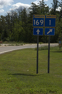
The route runs concurrent
with State Highway 1
for 26 miles (41.8 km) from Vermilion Lake Township (west of Tower
) to Ely
.
Minnesota State Highway 169 is 49 miles (78.9 km) in length.
 State Highway 169 serves as a north–south route in northeast Minnesota between the cities of Virginia
, Tower
, Ely
, and Winton
.
The route passes through the Superior National Forest
at two different points.
Soudan Underground Mine State Park
is located near State Highway 169, two miles east of Tower
.
Bear Head Lake State Park
is located 7 miles south of the junction
of State Highway 169 and County Road 128 (in Breitung Township, 9 miles east of Tower
). The park entrance is located on County Road 128.
State Highway 169 is one of three Minnesota state marked highways to carry the same number as an existing U.S. marked highway within the state, the others being Highways 61
and 65
.
.
The route was authorized on April 22, 1933 from the city of Virginia
to the junction
with Highway 135
(formerly 35) in Tower
, where the highway terminated until 1953.
The six-mile (10 km) segment running from Ely
to Fall Lake Township was authorized in 1949 and originally designated State Highway 221 until 1953, when State Highway 169 was extended over State Highway 1
to Ely.
Highway 169 was paved by 1940. The segment east of Ely was paved by 1950.
Highway
A highway is any public road. In American English, the term is common and almost always designates major roads. In British English, the term designates any road open to the public. Any interconnected set of highways can be variously referred to as a "highway system", a "highway network", or a...
in northeast Minnesota
Minnesota
Minnesota is a U.S. state located in the Midwestern United States. The twelfth largest state of the U.S., it is the twenty-first most populous, with 5.3 million residents. Minnesota was carved out of the eastern half of the Minnesota Territory and admitted to the Union as the thirty-second state...
, which runs from its interchange
Interchange (road)
In the field of road transport, an interchange is a road junction that typically uses grade separation, and one or more ramps, to permit traffic on at least one highway to pass through the junction without directly crossing any other traffic stream. It differs from a standard intersection, at which...
with U.S. Highway 53
U.S. Route 53
U.S. Route 53 is a north–south U.S. highway that runs for 403 miles from La Crosse, Wisconsin to northern Minnesota. It is the primary north–south route in northwestern Wisconsin, serving as a vital link between I-94 at Eau Claire, Wisconsin and the city of Duluth, Minnesota...
in Wuori Township (immediately north of the city of Virginia
Virginia, Minnesota
As of the census of 2000, there were 9,157 people, 4,333 households, and 2,270 families residing in the city. The population density was 486.1 people per square mile . There were 4,692 housing units at an average density of 249.1 per square mile...
) and continues northeast to its northern terminus at the intersection
Intersection (road)
An intersection is a road junction where two or more roads either meet or cross at grade . An intersection may be 3-way - a T junction or fork, 4-way - a crossroads, or 5-way or more...
of Lake County Road 18 and Power Dam Road in Fall Lake Township (6-miles east of Ely
Ely, Minnesota
As of the census of 2000, there were 3,724 people, 1,912 households, and 916 families residing in the city. The population density was 1,369.5 people per square mile . There were 1,912 housing units at an average density of 703.2 per square mile...
). State Highway 169 becomes Lake County Road 18 at this point.
State Highway 169 is numbered as an extension of U.S. Highway 169
U.S. Route 169 in Minnesota
U.S. Route 169 is a major north–south highway in the U.S. state of Minnesota, connecting the Minnesota River valley with the Twin Cities and the Iron Range. Much of the route is built to expressway or freeway standards.-Route description:U.S...
, using the same mileage that began at the Iowa state line.
The route runs concurrent
Concurrency (road)
A concurrency, overlap, or coincidence in a road network is an instance of one physical road bearing two or more different highway, motorway, or other route numbers...
with State Highway 1
Minnesota State Highway 1
Minnesota State Highway 1 is a highway in northwest and northeast Minnesota, which runs from North Dakota Highway 54 at the North Dakota state line and continues east to its eastern terminus at its intersection with Minnesota Highway 61 at the unincorporated town of Illgen City in Beaver Bay...
for 26 miles (41.8 km) from Vermilion Lake Township (west of Tower
Tower, Minnesota
As of the census of 2000, there are 479 people in the city, organized into 233 households and 137 families. The population density is 176.8 people per square mile . There are 295 housing units at an average density of 108.9 per square mile...
) to Ely
Ely, Minnesota
As of the census of 2000, there were 3,724 people, 1,912 households, and 916 families residing in the city. The population density was 1,369.5 people per square mile . There were 1,912 housing units at an average density of 703.2 per square mile...
.
Minnesota State Highway 169 is 49 miles (78.9 km) in length.
Route description
Virginia, Minnesota
As of the census of 2000, there were 9,157 people, 4,333 households, and 2,270 families residing in the city. The population density was 486.1 people per square mile . There were 4,692 housing units at an average density of 249.1 per square mile...
, Tower
Tower, Minnesota
As of the census of 2000, there are 479 people in the city, organized into 233 households and 137 families. The population density is 176.8 people per square mile . There are 295 housing units at an average density of 108.9 per square mile...
, Ely
Ely, Minnesota
As of the census of 2000, there were 3,724 people, 1,912 households, and 916 families residing in the city. The population density was 1,369.5 people per square mile . There were 1,912 housing units at an average density of 703.2 per square mile...
, and Winton
Winton, Minnesota
Winton is a city in Saint Louis County, Minnesota, United States. The population was 172 at the 2010 census. The city is home to a small hydroelectric dam on the edge of Garden Lake, one of 11 stations owned by Minnesota Power...
.
The route passes through the Superior National Forest
Superior National Forest
Superior National Forest, part of the United States National Forest system, is located in the Arrowhead Region of the state of Minnesota between the Canada – United States border and the north shore of Lake Superior...
at two different points.
Soudan Underground Mine State Park
Soudan Underground Mine State Park
The Soudan Underground Mine State Park is a Minnesota state park at the site of the Soudan Underground Mine, on the south shore of Lake Vermilion. The mine is known as Minnesota's oldest, deepest, and richest iron mine, and now hosts the Soudan Underground Laboratory. As the Soudan Iron Mine, it...
is located near State Highway 169, two miles east of Tower
Tower, Minnesota
As of the census of 2000, there are 479 people in the city, organized into 233 households and 137 families. The population density is 176.8 people per square mile . There are 295 housing units at an average density of 108.9 per square mile...
.
Bear Head Lake State Park
Bear Head Lake State Park
Bear Head Lake State Park is a state park in northern Minnesota, USA, near the Boundary Waters Canoe Area Wilderness in St. Louis County.In September 2010, Bear Head Lake State Park was voted "America's Favorite Park" in an online poll run by Coca-Cola. The Minnesota Department of Natural...
is located 7 miles south of the junction
Junction (traffic)
A junction, when discussed in the context of transport, is a location where traffic can change between different routes, directions, or sometimes modes, of travel.-Historical significance:...
of State Highway 169 and County Road 128 (in Breitung Township, 9 miles east of Tower
Tower, Minnesota
As of the census of 2000, there are 479 people in the city, organized into 233 households and 137 families. The population density is 176.8 people per square mile . There are 295 housing units at an average density of 108.9 per square mile...
). The park entrance is located on County Road 128.
State Highway 169 is one of three Minnesota state marked highways to carry the same number as an existing U.S. marked highway within the state, the others being Highways 61
Minnesota State Highway 61
Minnesota State Highway 61 is a highway in northeast Minnesota, which runs from the junction of Interstate Highway 35 and Minnesota 61 in Duluth and continues northeast to its northern terminus at the U.S.-Canadian border near Grand Portage...
and 65
Minnesota State Highway 65
Minnesota State Highway 65 is a highway in east-central and northeast Minnesota, which runs from its intersection with Washington Avenue at the north end of downtown Minneapolis and continues north to its northern terminus at its intersection with U.S...
.
History
State Highway 169 was numbered as an extension of U.S. 169U.S. Route 169 in Minnesota
U.S. Route 169 is a major north–south highway in the U.S. state of Minnesota, connecting the Minnesota River valley with the Twin Cities and the Iron Range. Much of the route is built to expressway or freeway standards.-Route description:U.S...
.
The route was authorized on April 22, 1933 from the city of Virginia
Virginia, Minnesota
As of the census of 2000, there were 9,157 people, 4,333 households, and 2,270 families residing in the city. The population density was 486.1 people per square mile . There were 4,692 housing units at an average density of 249.1 per square mile...
to the junction
Junction (traffic)
A junction, when discussed in the context of transport, is a location where traffic can change between different routes, directions, or sometimes modes, of travel.-Historical significance:...
with Highway 135
Minnesota State Highway 135
Minnesota State Highway 135 is a highway in northeast Minnesota, which runs from its interchange with U.S. Highway 53 in the city of Virginia and continues northeast to its northern terminus at its intersection with State Highway 1 in Tower....
(formerly 35) in Tower
Tower, Minnesota
As of the census of 2000, there are 479 people in the city, organized into 233 households and 137 families. The population density is 176.8 people per square mile . There are 295 housing units at an average density of 108.9 per square mile...
, where the highway terminated until 1953.
The six-mile (10 km) segment running from Ely
Ely, Minnesota
As of the census of 2000, there were 3,724 people, 1,912 households, and 916 families residing in the city. The population density was 1,369.5 people per square mile . There were 1,912 housing units at an average density of 703.2 per square mile...
to Fall Lake Township was authorized in 1949 and originally designated State Highway 221 until 1953, when State Highway 169 was extended over State Highway 1
Minnesota State Highway 1
Minnesota State Highway 1 is a highway in northwest and northeast Minnesota, which runs from North Dakota Highway 54 at the North Dakota state line and continues east to its eastern terminus at its intersection with Minnesota Highway 61 at the unincorporated town of Illgen City in Beaver Bay...
to Ely.
Highway 169 was paved by 1940. The segment east of Ely was paved by 1950.