

Minnesota State Highway 1
Encyclopedia
Minnesota State Highway 1 is a highway
in northwest and northeast Minnesota
, which runs from North Dakota Highway 54 at the North Dakota
state line (at the Red River
in Oslo
) and continues east to its eastern terminus at its intersection
with Minnesota Highway 61
at the unincorporated town of Illgen City
in Beaver Bay Township on the North Shore
of Lake Superior
. At 346 miles (556.8 km) in length, Highway 1 is the longest state route in Minnesota.
, Warren
, Thief River Falls
, Red Lake
, Northome
, Cook
, Tower
, Ely
, and Beaver Bay Township.
The roadway passes through the following forests:
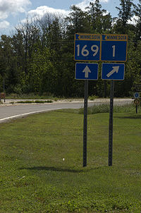 The route runs concurrent
with State Highway 169
for 26 miles (41.8 km) from Vermilion Lake Township (west of Tower
) to Ely
.
State Highway 1 also runs concurrent with State Highway 89
for 28 miles (45.1 km) on the southwest side of Red Lake. This is the longest concurrency with another state highway within Minnesota.
and State Highway 32
at Thief River Falls which was part of Minnesota Constitutional Route 33 authorized in 1920.
The route was given the Highway 1 designation because it was one of the longest trunk highways, and would allow re-use of the Route 1 markers removed from along U.S. 61
and U.S. 65
in 1934.
When it was marked in 1934, it was only paved from U.S. 75 to Highway 32 and from Highway 169 to Ely.
As recently as 1963, significant portions of Highway 1 were unpaved.
Highway 1 still had an unpaved segment in 1996, between U.S. 53
and State Highway 169
in northern Saint Louis County. At that point it was swapped with paved Saint Louis County Road 22.
|colspan=2|Red River of the North
|0.000
|
|
|-
Highway
A highway is any public road. In American English, the term is common and almost always designates major roads. In British English, the term designates any road open to the public. Any interconnected set of highways can be variously referred to as a "highway system", a "highway network", or a...
in northwest and northeast Minnesota
Minnesota
Minnesota is a U.S. state located in the Midwestern United States. The twelfth largest state of the U.S., it is the twenty-first most populous, with 5.3 million residents. Minnesota was carved out of the eastern half of the Minnesota Territory and admitted to the Union as the thirty-second state...
, which runs from North Dakota Highway 54 at the North Dakota
North Dakota
North Dakota is a state located in the Midwestern region of the United States of America, along the Canadian border. The state is bordered by Canada to the north, Minnesota to the east, South Dakota to the south and Montana to the west. North Dakota is the 19th-largest state by area in the U.S....
state line (at the Red River
Red River of the North
The Red River is a North American river. Originating at the confluence of the Bois de Sioux and Otter Tail rivers in the United States, it flows northward through the Red River Valley and forms the border between the U.S. states of Minnesota and North Dakota before continuing into Manitoba, Canada...
in Oslo
Oslo, Minnesota
Oslo is a city in Marshall County, Minnesota, United States. The population was 330 at the 2010 census.Minnesota Highway 1 and Minnesota Highway 220 are two of the main arterial routes in the community...
) and continues east to its eastern terminus at its intersection
Intersection (road)
An intersection is a road junction where two or more roads either meet or cross at grade . An intersection may be 3-way - a T junction or fork, 4-way - a crossroads, or 5-way or more...
with Minnesota Highway 61
Minnesota State Highway 61
Minnesota State Highway 61 is a highway in northeast Minnesota, which runs from the junction of Interstate Highway 35 and Minnesota 61 in Duluth and continues northeast to its northern terminus at the U.S.-Canadian border near Grand Portage...
at the unincorporated town of Illgen City
Illgen City, Minnesota
Illgen City is an unincorporated community in Lake County, Minnesota, United States.The community is located immediately northeast of the city of Silver Bay at the junction of Minnesota Highway 61 and Minnesota Highway 1....
in Beaver Bay Township on the North Shore
North Shore (Lake Superior)
The North Shore of Lake Superior runs from Duluth, Minnesota, United States, at the southwestern end of the lake, to Thunder Bay and Nipigon, Ontario, Canada, in the north to Sault Ste. Marie, Ontario, in the east...
of Lake Superior
Lake Superior
Lake Superior is the largest of the five traditionally-demarcated Great Lakes of North America. It is bounded to the north by the Canadian province of Ontario and the U.S. state of Minnesota, and to the south by the U.S. states of Wisconsin and Michigan. It is the largest freshwater lake in the...
. At 346 miles (556.8 km) in length, Highway 1 is the longest state route in Minnesota.
Route description
State Highway 1 serves as an east–west route between OsloOslo, Minnesota
Oslo is a city in Marshall County, Minnesota, United States. The population was 330 at the 2010 census.Minnesota Highway 1 and Minnesota Highway 220 are two of the main arterial routes in the community...
, Warren
Warren, Minnesota
As of the census of 2000, there were 1,678 people, 699 households, and 432 families residing in the city. The population density was 1,174.1 people per square mile . There were 785 housing units at an average density of 549.3 per square mile...
, Thief River Falls
Thief River Falls, Minnesota
As of the census of 2000, there were 8,410 people, 3,619 households, and 2,091 families residing in the city. The population density was 1,760.0 people per square mile . There were 3,931 housing units at an average density of 822.7 per square mile...
, Red Lake
Red Lake, Minnesota
There is also a Red Lake County in Minnesota.Red Lake is a census-designated place within the Lower Red Lake unorganized territory located in Beltrami County, Minnesota, United States. As of the 2000 census, Red Lake had a total population of 1,436...
, Northome
Northome, Minnesota
Northome is a city located in the southwestern corner of Koochiching County, Minnesota, United States. The population was 200 at the 2010 census. The county seat is International Falls, about away.U.S...
, Cook
Cook, Minnesota
Cook is a city in Saint Louis County, Minnesota, United States. The population was 574 at the 2010 census.U.S. Highway 53 and Minnesota Highway 1 are two of the main arterial routes in the community....
, Tower
Tower, Minnesota
As of the census of 2000, there are 479 people in the city, organized into 233 households and 137 families. The population density is 176.8 people per square mile . There are 295 housing units at an average density of 108.9 per square mile...
, Ely
Ely, Minnesota
As of the census of 2000, there were 3,724 people, 1,912 households, and 916 families residing in the city. The population density was 1,369.5 people per square mile . There were 1,912 housing units at an average density of 703.2 per square mile...
, and Beaver Bay Township.
The roadway passes through the following forests:
- Finland State ForestFinland State ForestThe Finland State Forest is a state forest located near the town of Finland in Lake and Cook counties, Minnesota. Of the over , the Minnesota Department of Natural Resources manages a third of the land. The federal United States Forest Service manages roughly a quarter of the total forest acreage,...
in Lake CountyLake County, MinnesotaLake County is a county located in the U.S. state of Minnesota. As of 2010, the population was 10,866. Its county seat is Two Harbors. Lake County was founded on February 20, 1855, as Superior County, though its name was changed on March 3, of that year to St. Louis County. On March 1, 1856, St... - Superior National ForestSuperior National ForestSuperior National Forest, part of the United States National Forest system, is located in the Arrowhead Region of the state of Minnesota between the Canada – United States border and the north shore of Lake Superior...
in LakeLake County, MinnesotaLake County is a county located in the U.S. state of Minnesota. As of 2010, the population was 10,866. Its county seat is Two Harbors. Lake County was founded on February 20, 1855, as Superior County, though its name was changed on March 3, of that year to St. Louis County. On March 1, 1856, St...
and Saint LouisSt. Louis County, MinnesotaSt. Louis County is a county located in the U.S. state of Minnesota. As of 2010, the population was 200,226. Its county seat is Duluth. It is the largest county by total area in Minnesota, and the second largest in the United States east of the Mississippi River; in land area alone, after Aroostook...
counties - Bear Island State ForestBear Island State ForestThe Bear Island State Forest is a state forest bordered by the towns of Ely, Babbitt, and Tower in Lake and St. Louis counties in Minnesota. It is adjacent to the Burntside State Forest and the federally-managed Superior National Forest and Boundary Waters Canoe Area Wilderness...
in LakeLake County, MinnesotaLake County is a county located in the U.S. state of Minnesota. As of 2010, the population was 10,866. Its county seat is Two Harbors. Lake County was founded on February 20, 1855, as Superior County, though its name was changed on March 3, of that year to St. Louis County. On March 1, 1856, St...
and Saint LouisSt. Louis County, MinnesotaSt. Louis County is a county located in the U.S. state of Minnesota. As of 2010, the population was 200,226. Its county seat is Duluth. It is the largest county by total area in Minnesota, and the second largest in the United States east of the Mississippi River; in land area alone, after Aroostook...
counties - Kabetogama State ForestKabetogama State ForestThe Kabetogama State Forest is a state forest located in Koochiching and St. Louis counties, Minnesota. The forest borders the Superior National Forest and the Boundary Waters Canoe Area Wilderness to the east, the Sturgeon River State Forest to the south, the Nett Lake Indian Reservation to the...
in Saint Louis CountySt. Louis County, MinnesotaSt. Louis County is a county located in the U.S. state of Minnesota. As of 2010, the population was 200,226. Its county seat is Duluth. It is the largest county by total area in Minnesota, and the second largest in the United States east of the Mississippi River; in land area alone, after Aroostook... - George Washington State ForestGeorge Washington State ForestThe George Washington State Forest is a state forest located in Itasca, Koochiching, and St. Louis counties, Minnesota. The forest was established and named after George Washington in 1931, the first President of the United States, to commemorate the bicentennial of his birth...
in Itasca CountyItasca County, MinnesotaItasca County is a county located in the U.S. state of Minnesota. It is named after Lake Itasca, which is in turn a shortened version the Latin words veritas caput, meaning 'truth' and 'head', a reference to the source of the Mississippi River. As of 2010, the population was 45,058. Its county seat... - Koochiching State ForestKoochiching State ForestThe Koochiching State Forest is a state forest located near International Falls in Itasca, Koochiching, and St. Louis counties, Minnesota. The forest borders the Pine Island State Forest to the west, the Big Fork State Forest and George Washington State Forest to the south, the Nett Lake Indian...
in Koochiching CountyKoochiching County, MinnesotaKoochiching County is a county located in the U.S. state of Minnesota. As of 2010, the population was 13,311. Its county seat is International Falls. A portion of the Bois Forte Indian Reservation is in the county. A small part of Voyageurs National Park extends into its northeast...
Concurrency (road)
A concurrency, overlap, or coincidence in a road network is an instance of one physical road bearing two or more different highway, motorway, or other route numbers...
with State Highway 169
Minnesota State Highway 169
Minnesota State Highway 169 is a highway in northeast Minnesota, which runs from its interchange with U.S. Highway 53 in Wuori Township and continues northeast to its northern terminus at the intersection of Lake County Road 18 and Power Dam Road in Fall Lake Township...
for 26 miles (41.8 km) from Vermilion Lake Township (west of Tower
Tower, Minnesota
As of the census of 2000, there are 479 people in the city, organized into 233 households and 137 families. The population density is 176.8 people per square mile . There are 295 housing units at an average density of 108.9 per square mile...
) to Ely
Ely, Minnesota
As of the census of 2000, there were 3,724 people, 1,912 households, and 916 families residing in the city. The population density was 1,369.5 people per square mile . There were 1,912 housing units at an average density of 703.2 per square mile...
.
State Highway 1 also runs concurrent with State Highway 89
Minnesota State Highway 89
Minnesota State Highway 89 is a highway in northwest Minnesota, which runs from its intersection with U.S. Highway 2 at Eckles Township, just north of Wilton and continues north to its northern terminus at Manitoba Highway 89 near Pinecreek. The route is in length.The highway runs around the...
for 28 miles (45.1 km) on the southwest side of Red Lake. This is the longest concurrency with another state highway within Minnesota.
History
Most of State Highway 1 was authorized in 1933, except for a section between U.S. 75U.S. Route 75
U.S. Route 75 is a north–south U.S. Highway. The highway's northern terminus is in Kittson County, Minnesota, at the Canadian border, where it continues as Manitoba Highway 75 on the other side of a closed border crossing. Its southern terminus is at Interstate 30 and Interstate 45 in Dallas,...
and State Highway 32
Minnesota State Highway 32
Minnesota State Highway 32 is a highway in west-central and northwest Minnesota, which runs from its intersection with State Highway 34 in Tansem Township near Barnesville and continues north to its northern terminus at its intersection with State Highway 11 in Greenbush at Roseau County.Highway 32...
at Thief River Falls which was part of Minnesota Constitutional Route 33 authorized in 1920.
The route was given the Highway 1 designation because it was one of the longest trunk highways, and would allow re-use of the Route 1 markers removed from along U.S. 61
U.S. Route 61
U.S. Route 61 is the official designation for a United States highway that runs from New Orleans, Louisiana, to the city of Wyoming, Minnesota. The highway generally follows the course of the Mississippi River, and is designated the Great River Road for much of its route. As of 2004, the highway's...
and U.S. 65
U.S. Route 65
U.S. Route 65 is a north–south United States highway in the southern and midwestern United States. The southern terminus of the route is at U.S. Route 425 in Clayton, Louisiana. The northern terminus is at Interstate 35 just south of Interstate 90 in Albert Lea, Minnesota...
in 1934.
When it was marked in 1934, it was only paved from U.S. 75 to Highway 32 and from Highway 169 to Ely.
As recently as 1963, significant portions of Highway 1 were unpaved.
Highway 1 still had an unpaved segment in 1996, between U.S. 53
U.S. Route 53
U.S. Route 53 is a north–south U.S. highway that runs for 403 miles from La Crosse, Wisconsin to northern Minnesota. It is the primary north–south route in northwestern Wisconsin, serving as a vital link between I-94 at Eau Claire, Wisconsin and the city of Duluth, Minnesota...
and State Highway 169
Minnesota State Highway 169
Minnesota State Highway 169 is a highway in northeast Minnesota, which runs from its interchange with U.S. Highway 53 in Wuori Township and continues northeast to its northern terminus at the intersection of Lake County Road 18 and Power Dam Road in Fall Lake Township...
in northern Saint Louis County. At that point it was swapped with paved Saint Louis County Road 22.
Major intersections
|-|colspan=2|Red River of the North
Red River of the North
The Red River is a North American river. Originating at the confluence of the Bois de Sioux and Otter Tail rivers in the United States, it flows northward through the Red River Valley and forms the border between the U.S. states of Minnesota and North Dakota before continuing into Manitoba, Canada...
|0.000
|
|
|-
External links
- Minnesota Highway 1, MN Highway Endings.