

Congress Lands North of Old Seven Ranges
Encyclopedia
The Congress Lands North of the Old Seven Ranges was a land tract in northeast Ohio
that was established by the Congress early in the 19th century. It is located south of the Connecticut Western Reserve
and Firelands
, east of the Congress Lands
South and East of the First Principal Meridian
, north of the United States Military District
and Seven Ranges
, and west of Pennsylvania
.
from France
following the 1763 Treaty of Paris
, the Ohio Country
had been closed to white settlement by the Proclamation of 1763. The United States claimed the region after the 1783 Treaty of Paris
that ended the American Revolutionary War
. The Congress
passed the Land Ordinance of 1785
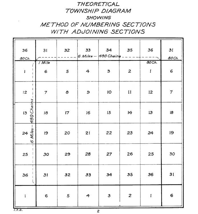
as a formal means of surveying, selling, and settling the land and raising revenue. Land was to be systematically surveyed into square "townships"
, six miles (9.656 km) on a side created by lines running north-south intersected by east-west lines. Townships were to be arranged in north-south rows called ranges. These townships were sub-divided into thirty-six "sections"
of one square mile (2.59 km²) or 640 acres. These ranges, townships, and sections were to be systematically numbered.
The first north-south line, Eastern Ohio Meridian
, was to be the western boundary of Pennsylvania, sometimes called Ellicott‘s Line after Andrew Ellicott
, who had been in charge of surveying it, and the first east-west line (called the Geographer’s Line or Base Line
) was to begin where the Pennsylvania boundary touched the north bank of the Ohio River, the Beginning Point of the U.S. Public Land Survey
40°38′33"N 80°31′10"W. The Geographer’s Line was to extend westward through “the whole territory” which at that time was meant to include lands lying between the Ohio River and Lake Erie.
A problem with this plan was that Connecticut
had a claim on lands north of the 41st parallel north
latitude. Thus, on May 9, 1786, Congress instructed Thomas Hutchins
, Geographer of the United States, to continue his survey only south of the Geographers line. Hutchins group completed surveying seven ranges by 1787, and presented plats to Congress in 1788 for the tract that became known as the Seven Ranges
.
On June 1, 1796, Congress created the United States Military District
, sometimes called the USMD Lands, or USMD Survey.. The district was west of the Old Seven Ranges and south of the Greenville Treaty Line.
westward from the Pennsylvania line to the Tuscarawas River
, lands were surveyed circa 1801 under the Act of May 18, 1796. The ranges and townships followed those of the original Seven Ranges, ranges being numbered westward from Pennsylvania, and townships within each range numbered from south to north starting at the Ohio River
, known as the Ohio River Base, thus having townships in adjacent ranges with different numbers. Sections were numbered according to the 1796 pattern.
The Treaty of Greenville
in 1795 had established land west of the Tuscarawas as reserved for Indians, and not open to American settlement. With the Treaty of Fort Industry
in 1805, Indian land west of the Tuscarawas River, between Lake Eire and the Greeneville Treaty Line, and east of a line 120 miles west of Pennsylvania, or about 82° 51' W longitude, was ceded by six tribes. Congress Lands in this ceded area were surveyed 1806-07. This survey had six mile square townships and continued the range, township, and section numbering system of the Ohio River Survey, section numbering being based on the 1796 land act.
The two surveys of 1801 and 1806-07 became known as the Congress Lands North of the Old Seven Ranges.
Lands North of the Old Seven Ranges and bounded on the north by the Connecticut Western Reserve. Townships are numbered 1 and 2 north, and the range is 10 west. The range continues the numbering of the Ohio River Survey. This survey was conducted in 1800. The civil townships of Lawrence Township, Stark County, Ohio
and Franklin Township, Summit County, Ohio correspond to this survey.
. The Land Act of May 10, 1800 established a land office
at Steubenville
for sales of these lands. The Act of March 3, 1807 established a land office for the Congress Lands North of Old Seven Ranges that ended up in Canton
, creating the Canton Land District. The Act of February 25, 1811 moved the office to Wooster
but kept the name Canton Land District. Sales were also conducted from the nation’s capital at the General Land Office
. Local offices were eventually closed. The State of Ohio also eventually sold lands granted to them by the federal government, such as section 16 of each township
.
, Carroll
, Columbiana
, Crawford
, Holmes
, Knox
, Mahoning, Morrow
, Richland
, Stark
, Summit
, and Wayne
.
Ohio
Ohio is a Midwestern state in the United States. The 34th largest state by area in the U.S.,it is the 7th‑most populous with over 11.5 million residents, containing several major American cities and seven metropolitan areas with populations of 500,000 or more.The state's capital is Columbus...
that was established by the Congress early in the 19th century. It is located south of the Connecticut Western Reserve
Connecticut Western Reserve
The Connecticut Western Reserve was land claimed by Connecticut from 1662 to 1800 in the Northwest Territory in what is now northeastern Ohio.-History:...
and Firelands
Firelands
The Firelands or Sufferers' Lands tract was located at the western end of the Connecticut Western Reserve in what is now the U.S. state of Ohio...
, east of the Congress Lands
Congress Lands
The Congress Lands was a group of land tracts in Ohio that made land available for sale to members of the general public through land offices in various cities, and through the General Land Office...
South and East of the First Principal Meridian
South and East of the First Principal Meridian
South and East of the First Principal Meridian is a land description in the American Midwest.In 1812, Congress authorized the Surveyor General to survey the northern and western border of Ohio “as soon as the consent of the Indians can be obtained.“ In 1817, the northern portion of the Ohio-Indiana...
, north of the United States Military District
United States Military District
The United States Military District was a land tract in central Ohio that was established by the Congress to compensate veterans of the American Revolutionary War for their service...
and Seven Ranges
Seven Ranges
The Seven Ranges was a land tract in eastern Ohio that was the first tract to be surveyed in what became the Public Land Survey System. The tract is across the northern edge, on the western edge, with the south and east sides along the Ohio River...
, and west of Pennsylvania
Pennsylvania
The Commonwealth of Pennsylvania is a U.S. state that is located in the Northeastern and Mid-Atlantic regions of the United States. The state borders Delaware and Maryland to the south, West Virginia to the southwest, Ohio to the west, New York and Ontario, Canada, to the north, and New Jersey to...
.
History
Acquired by Great BritainGreat Britain
Great Britain or Britain is an island situated to the northwest of Continental Europe. It is the ninth largest island in the world, and the largest European island, as well as the largest of the British Isles...
from France
France
The French Republic , The French Republic , The French Republic , (commonly known as France , is a unitary semi-presidential republic in Western Europe with several overseas territories and islands located on other continents and in the Indian, Pacific, and Atlantic oceans. Metropolitan France...
following the 1763 Treaty of Paris
Treaty of Paris (1763)
The Treaty of Paris, often called the Peace of Paris, or the Treaty of 1763, was signed on 10 February 1763, by the kingdoms of Great Britain, France and Spain, with Portugal in agreement. It ended the French and Indian War/Seven Years' War...
, the Ohio Country
Ohio Country
The Ohio Country was the name used in the 18th century for the regions of North America west of the Appalachian Mountains and in the region of the upper Ohio River south of Lake Erie...
had been closed to white settlement by the Proclamation of 1763. The United States claimed the region after the 1783 Treaty of Paris
Treaty of Paris (1783)
The Treaty of Paris, signed on September 3, 1783, ended the American Revolutionary War between Great Britain on the one hand and the United States of America and its allies on the other. The other combatant nations, France, Spain and the Dutch Republic had separate agreements; for details of...
that ended the American Revolutionary War
American Revolutionary War
The American Revolutionary War , the American War of Independence, or simply the Revolutionary War, began as a war between the Kingdom of Great Britain and thirteen British colonies in North America, and ended in a global war between several European great powers.The war was the result of the...
. The Congress
Congress of the Confederation
The Congress of the Confederation or the United States in Congress Assembled was the governing body of the United States of America that existed from March 1, 1781, to March 4, 1789. It comprised delegates appointed by the legislatures of the states. It was the immediate successor to the Second...
passed the Land Ordinance of 1785
Land Ordinance of 1785
The Land Ordinance of 1785 was adopted by the United States Congress on May 20, 1785. Under the Articles of Confederation, Congress did not have the power to raise revenue by direct taxation of the inhabitants of the United States...
as a formal means of surveying, selling, and settling the land and raising revenue. Land was to be systematically surveyed into square "townships"
Survey township
Survey township, sometimes called Congressional township, as used by the United States Public Land Survey System, refers to a square unit of land, that is nominally six miles on a side...
, six miles (9.656 km) on a side created by lines running north-south intersected by east-west lines. Townships were to be arranged in north-south rows called ranges. These townships were sub-divided into thirty-six "sections"
Section (United States land surveying)
In U.S. land surveying under the Public Land Survey System , a section is an area nominally one square mile, containing , with 36 sections making up one survey township on a rectangular grid....
of one square mile (2.59 km²) or 640 acres. These ranges, townships, and sections were to be systematically numbered.
The first north-south line, Eastern Ohio Meridian
Meridian (geography)
A meridian is an imaginary line on the Earth's surface from the North Pole to the South Pole that connects all locations along it with a given longitude. The position of a point along the meridian is given by its latitude. Each meridian is perpendicular to all circles of latitude...
, was to be the western boundary of Pennsylvania, sometimes called Ellicott‘s Line after Andrew Ellicott
Andrew Ellicott
Andrew Ellicott was a U.S. surveyor who helped map many of the territories west of the Appalachians, surveyed the boundaries of the District of Columbia, continued and completed Pierre Charles L'Enfant's work on the plan for Washington, D.C., and served as a teacher in survey methods for...
, who had been in charge of surveying it, and the first east-west line (called the Geographer’s Line or Base Line
Baseline (surveying)
In the United States Public Land Survey System, a baseline is the principal east-west line that divides survey townships between north and south. The baseline meets its corresponding meridian at the point of origin, or initial point, for the land survey...
) was to begin where the Pennsylvania boundary touched the north bank of the Ohio River, the Beginning Point of the U.S. Public Land Survey
Beginning Point of the U.S. Public Land Survey
The Beginning Point of the U.S. Public Land Survey is a monument at the border between the U.S. states of Ohio and Pennsylvania, on the north side of the Ohio River. It is near the three-way intersection of Ohio, Pennsylvania, and the northern tip of West Virginia, in both the Pittsburgh...
40°38′33"N 80°31′10"W. The Geographer’s Line was to extend westward through “the whole territory” which at that time was meant to include lands lying between the Ohio River and Lake Erie.
A problem with this plan was that Connecticut
Connecticut
Connecticut is a state in the New England region of the northeastern United States. It is bordered by Rhode Island to the east, Massachusetts to the north, and the state of New York to the west and the south .Connecticut is named for the Connecticut River, the major U.S. river that approximately...
had a claim on lands north of the 41st parallel north
41st parallel north
The 41st parallel north is a circle of latitude that is 41 degrees north of the Earth's equatorial plane. It crosses Europe, the Mediterranean Sea, Asia, the Pacific Ocean, North America, and the Atlantic Ocean....
latitude. Thus, on May 9, 1786, Congress instructed Thomas Hutchins
Thomas Hutchins
Thomas Hutchins was an American military engineer, cartographer, geographer and surveyor.He joined the militia during the French and Indian War and later took a regular commission with British forces...
, Geographer of the United States, to continue his survey only south of the Geographers line. Hutchins group completed surveying seven ranges by 1787, and presented plats to Congress in 1788 for the tract that became known as the Seven Ranges
Seven Ranges
The Seven Ranges was a land tract in eastern Ohio that was the first tract to be surveyed in what became the Public Land Survey System. The tract is across the northern edge, on the western edge, with the south and east sides along the Ohio River...
.
On June 1, 1796, Congress created the United States Military District
United States Military District
The United States Military District was a land tract in central Ohio that was established by the Congress to compensate veterans of the American Revolutionary War for their service...
, sometimes called the USMD Lands, or USMD Survey.. The district was west of the Old Seven Ranges and south of the Greenville Treaty Line.
The Survey
An un-surveyed tract of land in eastern Ohio remained north of the Seven Ranges and Military District, and south of the Connecticut Western Reserve. In that gap, extendingwestward from the Pennsylvania line to the Tuscarawas River
Tuscarawas River
The Tuscarawas River is a principal tributary of the Muskingum River, 129.9 miles long, in northeastern Ohio in the United States...
, lands were surveyed circa 1801 under the Act of May 18, 1796. The ranges and townships followed those of the original Seven Ranges, ranges being numbered westward from Pennsylvania, and townships within each range numbered from south to north starting at the Ohio River
Ohio River
The Ohio River is the largest tributary, by volume, of the Mississippi River. At the confluence, the Ohio is even bigger than the Mississippi and, thus, is hydrologically the main stream of the whole river system, including the Allegheny River further upstream...
, known as the Ohio River Base, thus having townships in adjacent ranges with different numbers. Sections were numbered according to the 1796 pattern.
The Treaty of Greenville
Treaty of Greenville
The Treaty of Greenville was signed at Fort Greenville , on August 3, 1795, between a coalition of Native Americans & Frontiers men, known as the Western Confederacy, and the United States following the Native American loss at the Battle of Fallen Timbers. It put an end to the Northwest Indian War...
in 1795 had established land west of the Tuscarawas as reserved for Indians, and not open to American settlement. With the Treaty of Fort Industry
Treaty of Fort Industry
The Treaty of Fort Industry was a successor treaty to the Treaty of Greenville, which moved the eastern boundary of Indian lands in northern Ohio from the Tuscarawas River and Cuyahoga River westward to a line 120 miles west of the Pennsylvania boundary, which coincided with the western boundary of...
in 1805, Indian land west of the Tuscarawas River, between Lake Eire and the Greeneville Treaty Line, and east of a line 120 miles west of Pennsylvania, or about 82° 51' W longitude, was ceded by six tribes. Congress Lands in this ceded area were surveyed 1806-07. This survey had six mile square townships and continued the range, township, and section numbering system of the Ohio River Survey, section numbering being based on the 1796 land act.
The two surveys of 1801 and 1806-07 became known as the Congress Lands North of the Old Seven Ranges.
Muskingum River Survey
This area consists of only two townships, within the CongressLands North of the Old Seven Ranges and bounded on the north by the Connecticut Western Reserve. Townships are numbered 1 and 2 north, and the range is 10 west. The range continues the numbering of the Ohio River Survey. This survey was conducted in 1800. The civil townships of Lawrence Township, Stark County, Ohio
Lawrence Township, Stark County, Ohio
Lawrence Township is one of the seventeen townships of Stark County, Ohio, United States. The 2000 census found 13,382 people in the township, 8,321 of whom lived in the unincorporated portions of the township.-Geography:...
and Franklin Township, Summit County, Ohio correspond to this survey.
Land Sales
Section 4 of the Land Act of May 18, 1796 provided that the lands between the Seven Ranges and the Western Reserve be sold at “Pittsburg“Pittsburgh, Pennsylvania
Pittsburgh is the second-largest city in the US Commonwealth of Pennsylvania and the county seat of Allegheny County. Regionally, it anchors the largest urban area of Appalachia and the Ohio River Valley, and nationally, it is the 22nd-largest urban area in the United States...
. The Land Act of May 10, 1800 established a land office
Federal Land Office
left|thumb|300px|alt=historical marker saying Federal Land Office This log building was constructed in 1801 by David Hoge on the west side of Third Street. It served as his home and as the first Federal land office in that part of the Northwest Territory known as the Seven Ranges. In 1809 it was...
at Steubenville
Steubenville, Ohio
Steubenville is a city located along the Ohio River in Jefferson County, Ohio on the Ohio-West Virginia border in the United States. It is the political county seat of Jefferson County. It is also a principal city of the Weirton–Steubenville, WV-OH Metropolitan Statistical Area...
for sales of these lands. The Act of March 3, 1807 established a land office for the Congress Lands North of Old Seven Ranges that ended up in Canton
Canton, Ohio
Canton is the county seat of Stark County in northeastern Ohio, approximately south of Akron and south of Cleveland.The City of Caton is the largest incorporated area within the Canton-Massillon Metropolitan Statistical Area...
, creating the Canton Land District. The Act of February 25, 1811 moved the office to Wooster
Wooster, Ohio
Wooster is a city in the U.S. state of Ohio and the county seat of Wayne County. The municipality is located in northeastern Ohio approximately SSW of Cleveland and SW of Akron. Wooster is noted as the location of The College of Wooster...
but kept the name Canton Land District. Sales were also conducted from the nation’s capital at the General Land Office
General Land Office
The General Land Office was an independent agency of the United States government responsible for public domain lands in the United States. It was created in 1812 to take over functions previously conducted by the United States Department of the Treasury...
. Local offices were eventually closed. The State of Ohio also eventually sold lands granted to them by the federal government, such as section 16 of each township
School Lands
The School Lands are part of the Ohio Lands, comprising land grants in Ohio from the United States federal government for public schools. Support for public education in the United States predates the constitution; two years before the adoption of the United States Constitution of 1787, the...
.
Modern Times
The Tract today includes all or part of these counties in Ohio: AshlandAshland County, Ohio
Ashland County is a county located in the state of Ohio, United States, and was formed in 1846 from parts of Huron, Lorain, Richland and Wayne Counties. As of the 2010 census, the population was 53,139. Its county seat is Ashland...
, Carroll
Carroll County, Ohio
Carroll County is a county located in the state of Ohio. As of 2010, the population was 28,836, no change from 2000. Its county seat is Carrollton. It is named for Charles Carroll of Carrollton, the last surviving signer of the Declaration of Independence....
, Columbiana
Columbiana County, Ohio
Columbiana County is a county located in the U.S. state of Ohio. As of 2010, the population was 107,841. It is named for Christopher Columbus and the county seat is Lisbon....
, Crawford
Crawford County, Ohio
Crawford County is a county located in the state of Ohio, United States. It was named for Colonel William Crawford, a soldier during the American Revolution....
, Holmes
Holmes County, Ohio
As of the census of 2000, there were 38,943 people, 11,337 households, and 9,194 families residing in the county. The population density was 92 people per square mile . There were 12,280 housing units at an average density of 29 per square mile...
, Knox
Knox County, Ohio
Knox County is a county located in the state of Ohio, United States. As of 2010, the population was 60,921. Its county seat is Mount Vernon and is named for Henry Knox, an officer in the American Revolutionary War who was later the first Secretary of War....
, Mahoning, Morrow
Morrow County, Ohio
Morrow County is a county located in the state of Ohio, United States. Shawnee people used the area for hunting purposes before white settlers arrived in the early 19th century. Morrow County was organized in 1848 from parts of four neighboring counties and named for Jeremiah Morrow, Governor of...
, Richland
Richland County, Ohio
Richland County is a county located in the state of Ohio, United States. As of the 2010 census, the population was 124,475. It is included in the Mansfield, Ohio, Metropolitan Statistical Area as well as the Mansfield–Bucyrus Combined Statistical Area....
, Stark
Stark County, Ohio
Stark County is a county located in the U.S. state of Ohio. As of the 2010 census, the population was 375,586. It is included in the Canton-Massillon, Ohio Metropolitan Statistical Area....
, Summit
Summit County, Ohio
Summit County is an urban county located in the state of Ohio, United States. As of the 2000 census, the population was 542,899. In the 2010 Census the population was 541,781. Its county seat is Akron...
, and Wayne
Wayne County, Ohio
Wayne County is a county located in the state of Ohio, United States, and is named for General "Mad" Anthony Wayne. As of the 2010 census, the population was 114,520. Its county seat is Wooster....
.