
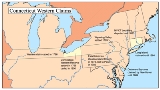
Connecticut Western Reserve
Encyclopedia
Connecticut
Connecticut is a state in the New England region of the northeastern United States. It is bordered by Rhode Island to the east, Massachusetts to the north, and the state of New York to the west and the south .Connecticut is named for the Connecticut River, the major U.S. river that approximately...
from 1662 to 1800 in the Northwest Territory
Northwest Territory
The Territory Northwest of the River Ohio, more commonly known as the Northwest Territory, was an organized incorporated territory of the United States that existed from July 13, 1787, until March 1, 1803, when the southeastern portion of the territory was admitted to the Union as the state of Ohio...
in what is now northeastern Ohio
Ohio
Ohio is a Midwestern state in the United States. The 34th largest state by area in the U.S.,it is the 7th‑most populous with over 11.5 million residents, containing several major American cities and seven metropolitan areas with populations of 500,000 or more.The state's capital is Columbus...
.
History
Pennsylvania
The Commonwealth of Pennsylvania is a U.S. state that is located in the Northeastern and Mid-Atlantic regions of the United States. The state borders Delaware and Maryland to the south, West Virginia to the southwest, Ohio to the west, New York and Ontario, Canada, to the north, and New Jersey to...
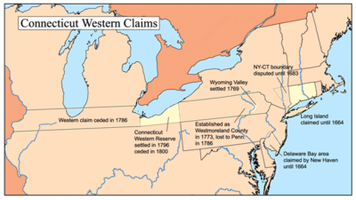
portion (Westmoreland County
Westmoreland County, Connecticut
Westmoreland County, Connecticut was a county established by the State of Connecticut in the present day area of Wyoming Valley, Pennsylvania, until it was ceded to Pennsylvania in 1784, of which it now forms the northeastern corner. It briefly seceded to become the State of Westmoreland...
) of its sea-to-sea land grant following the Yankee-Pennamite Wars and the intercession of the federal government, Connecticut held fast to its claim to the lands between the 41st
41st parallel north
The 41st parallel north is a circle of latitude that is 41 degrees north of the Earth's equatorial plane. It crosses Europe, the Mediterranean Sea, Asia, the Pacific Ocean, North America, and the Atlantic Ocean....
and 42nd-and-2-minutes parallels that lay west of the Pennsylvania border.
Within Ohio the claim was a 120 miles (193.1 km) wide strip between Lake Erie
Lake Erie
Lake Erie is the fourth largest lake of the five Great Lakes in North America, and the tenth largest globally. It is the southernmost, shallowest, and smallest by volume of the Great Lakes and therefore also has the shortest average water residence time. It is bounded on the north by the...
and a line just south of Youngstown
Youngstown, Ohio
Youngstown is a city in the U.S. state of Ohio and the county seat of Mahoning County; it also extends into Trumbull County. The municipality is situated on the Mahoning River, approximately southeast of Cleveland and northwest of Pittsburgh, Pennsylvania...
, Akron
Akron, Ohio
Akron , is the fifth largest city in the U.S. state of Ohio and the county seat of Summit County. It is located in the Great Lakes region approximately south of Lake Erie along the Little Cuyahoga River. As of the 2010 census, the city had a population of 199,110. The Akron Metropolitan...
, New London
New London, Ohio
New London is a village in Huron County, Ohio, United States. The population was 2,696 at the 2000 census.The village motto, "The Right Place at the Right Time" was chosen in the late twentieth century by former Mayor Dorothy Sholes....
, and Willard
Willard, Ohio
Willard is a city in Huron County, Ohio, United States. As of the 2000 census, the city population was 6,806. Willard is served by the Willard Memorial Library.-Geography:Willard is located at ....
, about 3 miles (4.8 km) south of the present-day U.S. Highway 224. Beyond Ohio the claim included parts of what would become Michigan
Michigan
Michigan is a U.S. state located in the Great Lakes Region of the United States of America. The name Michigan is the French form of the Ojibwa word mishigamaa, meaning "large water" or "large lake"....
, Indiana
Indiana
Indiana is a US state, admitted to the United States as the 19th on December 11, 1816. It is located in the Midwestern United States and Great Lakes Region. With 6,483,802 residents, the state is ranked 15th in population and 16th in population density. Indiana is ranked 38th in land area and is...
, Illinois
Illinois
Illinois is the fifth-most populous state of the United States of America, and is often noted for being a microcosm of the entire country. With Chicago in the northeast, small industrial cities and great agricultural productivity in central and northern Illinois, and natural resources like coal,...
, Iowa
Iowa
Iowa is a state located in the Midwestern United States, an area often referred to as the "American Heartland". It derives its name from the Ioway people, one of the many American Indian tribes that occupied the state at the time of European exploration. Iowa was a part of the French colony of New...
, Nebraska
Nebraska
Nebraska is a state on the Great Plains of the Midwestern United States. The state's capital is Lincoln and its largest city is Omaha, on the Missouri River....
, Wyoming
Wyoming
Wyoming is a state in the mountain region of the Western United States. The western two thirds of the state is covered mostly with the mountain ranges and rangelands in the foothills of the Eastern Rocky Mountains, while the eastern third of the state is high elevation prairie known as the High...
, Utah
Utah
Utah is a state in the Western United States. It was the 45th state to join the Union, on January 4, 1896. Approximately 80% of Utah's 2,763,885 people live along the Wasatch Front, centering on Salt Lake City. This leaves vast expanses of the state nearly uninhabited, making the population the...
, Nevada
Nevada
Nevada is a state in the western, mountain west, and southwestern regions of the United States. With an area of and a population of about 2.7 million, it is the 7th-largest and 35th-most populous state. Over two-thirds of Nevada's people live in the Las Vegas metropolitan area, which contains its...
, and California
California
California is a state located on the West Coast of the United States. It is by far the most populous U.S. state, and the third-largest by land area...
. The east boundary of the reserve follows a true meridian
Meridian (geography)
A meridian is an imaginary line on the Earth's surface from the North Pole to the South Pole that connects all locations along it with a given longitude. The position of a point along the meridian is given by its latitude. Each meridian is perpendicular to all circles of latitude...
along Ellicott‘s Line
Andrew Ellicott
Andrew Ellicott was a U.S. surveyor who helped map many of the territories west of the Appalachians, surveyed the boundaries of the District of Columbia, continued and completed Pierre Charles L'Enfant's work on the plan for Washington, D.C., and served as a teacher in survey methods for...
, the boundary with Pennsylvania. The west boundary veers more than four degrees from a meridian to maintain the 120 mile width, due to convergence.
Connecticut, like several other states, gave up western land claims in exchange for federal assumption of its American Revolutionary War
American Revolutionary War
The American Revolutionary War , the American War of Independence, or simply the Revolutionary War, began as a war between the Kingdom of Great Britain and thirteen British colonies in North America, and ended in a global war between several European great powers.The war was the result of the...
debt. The deed of cession was issued on 13 September 1786. However, Connecticut retained 3366921 acres (13,625.5 km²) in Ohio, which became the "Western Reserve".
In 1796 (or possibly 12 August 2 September , or 5 September 1795), Connecticut sold title to the land in the Western Reserve to the Connecticut Land Company
Connecticut Land Company
The Connecticut Land Company was formed in the late eighteenth century to survey and encourage settlement in the Connecticut Western Reserve, part of the Old Northwest Territory. The Western Reserve is located in Northeast Ohio with its hub being Cleveland. In 1795, the Connecticut Land Company...
for $1,200,000.
The Land Company was a group of investors who were mostly from Suffield, Connecticut
Suffield, Connecticut
Suffield is a town in Hartford County, Connecticut, United States. It had once been within the boundaries of Massachusetts. The town is located in the Connecticut River Valley with the town of Enfield neighboring to the east. In 1900, 3,521 people lived in Suffield; and in 1910, 3,841. As of the...
. There were initially eight in the group (or possibly 7 or 35). They planned to divide the land and sell it to settlers from the east. The Indian
Native Americans in the United States
Native Americans in the United States are the indigenous peoples in North America within the boundaries of the present-day continental United States, parts of Alaska, and the island state of Hawaii. They are composed of numerous, distinct tribes, states, and ethnic groups, many of which survive as...
title to the Reserve had not been extinguished. Clear title was obtained east of the Cuyahoga River
Cuyahoga River
The Cuyahoga River is located in Northeast Ohio in the United States. Outside of Ohio, the river is most famous for being "the river that caught fire", helping to spur the environmental movement in the late 1960s...
in the Greenville Treaty in 1795, and west of the river in the Treaty of Fort Industry
Treaty of Fort Industry
The Treaty of Fort Industry was a successor treaty to the Treaty of Greenville, which moved the eastern boundary of Indian lands in northern Ohio from the Tuscarawas River and Cuyahoga River westward to a line 120 miles west of the Pennsylvania boundary, which coincided with the western boundary of...
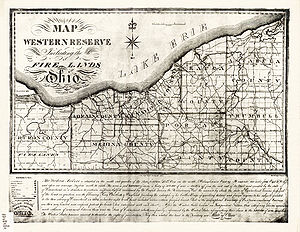
in 1805. The western end of the reserve included the 500000 acres (2,023.4 km²) Firelands
Firelands
The Firelands or Sufferers' Lands tract was located at the western end of the Connecticut Western Reserve in what is now the U.S. state of Ohio...
or "Sufferers Lands" reserved for residents of several New England
New England
New England is a region in the northeastern corner of the United States consisting of the six states of Maine, New Hampshire, Vermont, Massachusetts, Rhode Island, and Connecticut...
towns destroyed by British-set fires during the Revolutionary War.
The next year, the Land Company sent surveyors
Surveying
See Also: Public Land Survey SystemSurveying or land surveying is the technique, profession, and science of accurately determining the terrestrial or three-dimensional position of points and the distances and angles between them...
led by Moses Cleaveland
Moses Cleaveland
Moses Cleaveland was a lawyer, politician, soldier, and surveyor from Connecticut who founded the U.S. city of Cleveland, Ohio, while surveying the Western Reserve in 1796.-Early life:...
to the Reserve to divide the land into townships
Township (United States)
A township in the United States is a small geographic area. Townships range in size from 6 to 54 square miles , with being the norm.The term is used in three ways....
. The townships laid out in this survey were squares 5 miles (8 km) on each side (25 square miles (64.7 km²)), unlike most of the those elsewhere in Ohio, which are 6 miles (9.7 km) on each side (36 square miles (93.2 km²)), following the guidelines of the Land Ordinance of 1785
Land Ordinance of 1785
The Land Ordinance of 1785 was adopted by the United States Congress on May 20, 1785. Under the Articles of Confederation, Congress did not have the power to raise revenue by direct taxation of the inhabitants of the United States...
.
Cleaveland's team also founded the city of Cleveland, which became the largest city in the region. (The first "a" was dropped by a printer early in the settlement's existence, Cleveland taking less room on a printed page than Cleaveland.)
The territory was originally named "New Connecticut", which was later discarded in favor of "Western Reserve." Over the next few years, settlers trickled in. Youngstown was founded in 1796, Warren
Warren, Ohio
As of the census of 2000, there were 46,832 people, 19,288 households and 12,035 families residing in the city. The population density was 2,912.4 people per square mile . There were 21,279 housing units at an average density of 1,322.9 per square mile...
in 1798, Hudson
Hudson, Ohio
Hudson is a city in Summit County, Ohio, United States. The population was 22,262 at the 2010 census. It is an affluent exurban community and is part of the Akron, Ohio Metropolitan Statistical Area...
in 1799, Ashtabula
Ashtabula, Ohio
As of the census of 2000, there were 20,962 people, 8,435 households, and 5,423 families residing in the city. The population density was 2,775.9 people per square mile . There were 9,151 housing units at an average density of 1,211.8 per square mile...
in 1803, and Stow
Stow, Ohio
Stow is a city in Summit County, Ohio, United States. The population was 32,139 at the 2000 census and 33,899 as of 2008. It is a suburban community that is part of the Akron metropolitan area. Stow is located adjacent to several other suburban communities in Summit and Portage Counties...
in 1804.
In 1800, Connecticut finally ceded sovereignty over the Western Reserve. It was absorbed by the Northwest Territory
Northwest Territory
The Territory Northwest of the River Ohio, more commonly known as the Northwest Territory, was an organized incorporated territory of the United States that existed from July 13, 1787, until March 1, 1803, when the southeastern portion of the territory was admitted to the Union as the state of Ohio...
which established Trumbull County
Trumbull County, Ohio
As of the census of 2000, there were 225,116 people, 89,020 households, and 61,690 families residing in the county. The population density was 365 people per square mile . There were 95,117 housing units at an average density of 154 per square mile...
there. As the former county seat of the territory, Warren calls itself "the historical capital of the Western Reserve." Later, several more counties were carved out of the territory.
The name "Western Reserve" survives in the area in various institutions (see Western Reserve (disambiguation)
Western Reserve (disambiguation)
Western Reserve may refer to:*The Connecticut Western Reserve, now northeastern Ohio**Western Reserve Academy**Western Reserve Eclectic Institute, now Hiram College**Western Reserve Historical Society...
).
Congress
United States Congress
The United States Congress is the bicameral legislature of the federal government of the United States, consisting of the Senate and the House of Representatives. The Congress meets in the United States Capitol in Washington, D.C....
has considered declaring the Western Reserve a National Heritage Area
National heritage area
National heritage area is a region defined by a government as notable for cultural, historic, natural or recreation reasons. Compared to a national park, a national heritage area is not subject to the same level of zoning and regulations on land use. They are typically managed at a local...
, to encourage preservation of historical sites and buildings there. There are 49 National Heritage Areas in the United States, one already in Ohio – the Ohio Canal of the Ohio and Erie Canal
Ohio and Erie Canal
The Ohio Canal or Ohio and Erie Canal was a canal constructed in the 1820s and early 1830s. It connected Akron, Summit County, with the Cuyahoga River near its mouth on Lake Erie in Cleveland, Cuyahoga County, and a few years later, with the Ohio River near Portsmouth, Scioto County, and then...
. A study on this decision was to be presented to Congress in 2011.
Architecture
Architecture in the Western Reserve mimicked that of the New England towns from which its settlers originally came. Many of the buildings were designed in the GeorgianGeorgian architecture
Georgian architecture is the name given in most English-speaking countries to the set of architectural styles current between 1720 and 1840. It is eponymous for the first four British monarchs of the House of Hanover—George I of Great Britain, George II of Great Britain, George III of the United...
, Federal and Greek Revival styles. Towns such as Aurora, Canfield
Canfield, Ohio
Canfield is an affluent suburban city located in Mahoning County, Ohio,[United States, at the intersection of U.S. Route 224 and State Route 46/U.S. Route 62, about ten miles southwest of Youngstown. As of the 2000 census, the city population was 7,374. It is part of the Youngstown-Warren-Boardman,...
, Gates Mills
Gates Mills, Ohio
Gates Mills is a village in Cuyahoga County, Ohio, United States. The population was 2,270 at the 2010 census. Gates Mills is an affluent suburb of Cleveland...
, Hudson
Hudson, Ohio
Hudson is a city in Summit County, Ohio, United States. The population was 22,262 at the 2010 census. It is an affluent exurban community and is part of the Akron, Ohio Metropolitan Statistical Area...
, Medina
Medina, Ohio
In the city the population was spread out with 29.9% under the age of 18, 7.2% from 18 to 24, 33.8% from 25 to 44, 18.8% from 45 to 64, and 10.2% who were 65 years of age or older. The median age was 33 years. For every 100 females there were 92.1 males...
, Milan
Milan, Ohio
Milan is a village in Erie and Huron counties in the U.S. state of Ohio. The population was 1,445 at the 2000 census.The Erie County portion of Milan is part of the Sandusky Metropolitan Statistical Area, while the Huron County portion is part of the Norwalk Micropolitan Statistical Area.-History...
, Norwalk
Norwalk, Ohio
At the 2000 census, there were 16,238 people, 6,377 households and 4,234 families residing in the city. The population density was 1,950.3 per square mile . There were 6,687 housing units at an average density of 803.1 per square mile...
, Painesville
Painesville, Ohio
As of the 2010 Census, there were 19,563 people. As of the census of 2000, there were 17,503 people, 6,525 households, and 4,032 families residing in the city. The population density was 2,928.6 people per square mile . There were 6,933 housing units at an average density of 1,160.0 per square mile...
, and Poland
Poland, Ohio
Poland is a village in Mahoning County, Ohio, United States. The population was 26,866 at the 2000 census. It is part of the Youngstown-Warren-Boardman, OH-PA Metropolitan Statistical Area.-History:...
exemplify the mixture of these styles and traditional New England town planning. Cleveland's Public Square
Public Square
Public Square is the central plaza in downtown Cleveland, Ohio, United States. It takes up four city blocks; Superior Avenue and Ontario Street cross through it. Cleveland's three tallest buildings, Key Tower, 200 Public Square and the Terminal Tower, face the square...
is even characteristic of a traditional New England town green.
Further reading
The following publications are in the collection of the Connecticut State Library (CSL):- The Public Records of the State of Connecticut [HistRef ConnDoc G25 1776-]. This multi-volume set contains the record of transactions of the Connecticut General Assembly. Each volume covers a given time period and has an index. Researchers interested in the Western Lands should consult these volumes to gain knowledge of the legislative actions and petitions granted by the Connecticut General Assembly.
- Burke, Thomas Aquinas. Ohio Lands: A Short History. [Columbus, OH]: Auditor of State, c1997 [CSL call number HistRef HD 243 .O3 B87 1997].
- Cherry, Peter Peterson. The Western Reserve and Early Ohio. Akron, OH: R. L. Fouse, 1921 [CSL call number F 495 .C52].
- Fedor, Ferenz. The Yankee Migration to the Firelands. s.l.: Fedor, 1976? [CSL call number F 497 .W5 F43 1976].
- Mathews, Alfred. Ohio and Her Western Reserve, With a Story of Three States Leading to the Latter, From Connecticut, by Way of Wyoming, Its Indian Wars and Massacre. New York: D. Appleton, 1902 [CSL call number F 491 .M42].
- Mills, William Stowell. The Story of the Western Reserve of Connecticut. New York: Printed for the author by Brown & Wilson Press [ca. 1900] [CSL call number F 497 .W5 M6].
- Peters, William E. Ohio Lands and Their Subdivision. Athens, OH: W. E. Peters, 1918 [CSL call number F 497 .W5 P47 1918].
- Rice, Harvey. Pioneers of the Western Reserve. Boston: Lee and Shepard, 1883 [CSL call number: F 497 .W5 R5 1883].
- Upton, Harriet Taylor. History of the Western Reserve. Chicago: Lewis Pub. Co., 1910 [CSL call number: F 497 .W5 U7].
- Wickham, Gertrude Van Rensselaer. Memorial to the Pioneer Women of the Western Reserve. [s.l.]: Whipporwill, [197- ] [CSL call number F 497 .W5 W63 1970z].
External links
- The Western Reserve Heritage Feasibility Study
- Western Reserve Historical Society, Cleveland, Ohio
- Research Guide to Connecticut's "Western Lands" or "Western Reserve"
- Connecticut Western Reserve article on h2g2H2g2h2g2 is a British-based collaborative online encyclopedia project engaged in the construction of, in its own words, "an unconventional guide to life, the universe, and everything", in the spirit of the fictional publication The Hitchhiker's Guide to the Galaxy from the science fiction comedy series...
- Encyclopedia of Cleveland History
- History of the Western Reserve
- Early Settlers Association of the Western Reserve
- Firelands Historical Society