
.gif)
Section (United States land surveying)
Encyclopedia

Public Land Survey System
The Public Land Survey System is a method used in the United States to survey and identify land parcels, particularly for titles and deeds of rural, wild or undeveloped land. Its basic units of area are the township and section. It is sometimes referred to as the rectangular survey system,...
(PLSS), a section is an area nominally one square mile
Square mile
The square mile is an imperial and US unit of measure for an area equal to the area of a square of one statute mile. It should not be confused with miles square, which refers to the number of miles on each side squared...
, containing 640 acre (259 ha), with 36 sections making up one survey township
Survey township
Survey township, sometimes called Congressional township, as used by the United States Public Land Survey System, refers to a square unit of land, that is nominally six miles on a side...
on a rectangular grid.
The legal description of a tract of land under the PLSS includes the name of the state
U.S. state
A U.S. state is any one of the 50 federated states of the United States of America that share sovereignty with the federal government. Because of this shared sovereignty, an American is a citizen both of the federal entity and of his or her state of domicile. Four states use the official title of...
, name of the county, township number, range number, section number, and portion of a section. Sections are customarily surveyed
Surveying
See Also: Public Land Survey SystemSurveying or land surveying is the technique, profession, and science of accurately determining the terrestrial or three-dimensional position of points and the distances and angles between them...
into smaller squares by repeated halving and quartering. A quarter section is 160 acres and a "quarter-quarter section" is 40 acre (16.2 ha). In 1832 the smallest area of land that could be acquired was reduced to the 40 acre quarter-quarter section, and this size parcel became entrenched in American mythology. After the Civil War
American Civil War
The American Civil War was a civil war fought in the United States of America. In response to the election of Abraham Lincoln as President of the United States, 11 southern slave states declared their secession from the United States and formed the Confederate States of America ; the other 25...
freed slaves were reckoned to be self-sufficient with "40 acres and a mule
40 acres and a mule
40 acres and a mule refers to the short-lived policy, during the last stages of the American Civil War in 1865, of providing arable land to black former slaves who had become free as a result of the advance of the Union armies into the territory previously controlled by the Confederacy,...
." In the 20th century real estate developers preferred working with 40 acre parcels. The phrases "front 40" and "back 40," referring to farms fields, indicate quarter-quarter sections of land.
One of the reasons for creating sections of 640 acres was the ease of dividing into halves and quarters while still maintaining a whole number of acres. A section can be halved seven times in this way, down to a 5 acre (2 ha) parcel, or half of a quarter-quarter-quarter section—an easily surveyed 50 square chain area. This system was of great practical value on the American frontier, where surveyors often had a shaky grasp of mathematics and were required to work quickly.
A description of a quarter-quarter section in standard abbreviated form, might look like "NW 1/4, NE 1/4, Sec. 34, T.3S, R.1W, 1st P.M.". In expanded form this would read "the Northwest quarter of the Northeast quarter of Section 34 of Township 3 South, Range 1 West, first Principal Meridian".
History
The existence of section lines made property descriptions far more straightforward than the old metes and boundsMetes and bounds
Metes and bounds is a system or method of describing land, real property or real estate. The system has been used in England for many centuries, and is still used there in the definition of general boundaries...
system. The establishment of standard east-west and north-south lines ("township" and "range lines") meant that deeds could be written without regard to temporary terrain features such as trees, piles of rocks, fences, and the like, and be worded in the style such as "Lying and being in Township 4 North; Range 7 West; and being the northwest quadrant of the southwest quadrant of said section," an exact description in this case of 40 acres, as there are 640 acre (259 ha) in a square mile.
The importance of "sections" was greatly enhanced by the passage of "An Ordinance for ascertaining the mode of disposing of lands in the Western Territory" of 1785 by the U.S. Congress (see Land Ordinance of 1785
Land Ordinance of 1785
The Land Ordinance of 1785 was adopted by the United States Congress on May 20, 1785. Under the Articles of Confederation, Congress did not have the power to raise revenue by direct taxation of the inhabitants of the United States...
). This law provided that lands outside the then-existing states could not be sold, otherwise distributed, or opened for settlement prior to being surveyed. The standard way of doing this was to divide the land into sections. An area six sections by six sections would define a township. Within this area, one section was designated as school land. As the entire parcel would not be necessary for the school and its grounds, the balance of it was to be sold, with the monies to go into the construction and upkeep of the school.
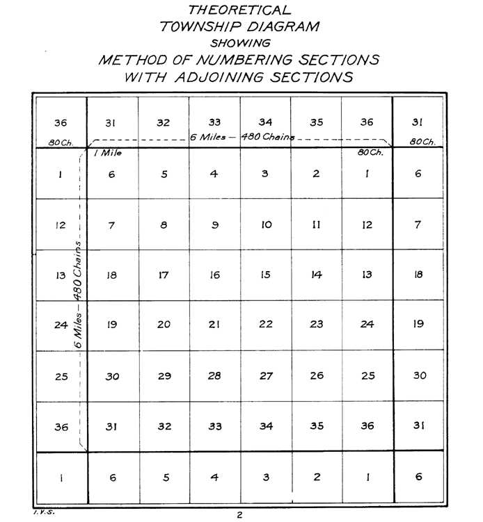
Numbering within a township
Every township is divided into 36 sections, each usually one-mile square. Sections are numbered boustrophedonBoustrophedon
Boustrophedon , is a type of bi-directional text, mostly seen in ancient manuscripts and other inscriptions. Every other line of writing is flipped or reversed, with reversed letters. Rather than going left-to-right as in modern English, or right-to-left as in Arabic and Hebrew, alternate lines in...
ically within townships as follows (north at top):
Subdivision of a section
Sections are (often) broken up into 40 acre blocks, or quarter quarter sections. These are labeled as follows:| NWNW | NENW | NWNE | NENE |
| SWNW | SENW | SWNE | SENE |
| NWSW | NESW | NWSE | NESE |
| SWSW | SESW | SWSE | SESE |
Measurement anomalies
Due to such factors as survey errors, poor instrumentation, difficult terrain, and sloppy work by surveyors, it is common for actual sections to differ from the PLSS ideal of one square mile. The distortions and errors were, by design, distributed to the northern and western edges of each township. As a result the sections in these areas diverge the most from the ideal shape and size. In addition there was a need to regularly adjust the entire township grid to account for distortions caused by the curvature of the Earth and the convergence of meridianMeridian (geography)
A meridian is an imaginary line on the Earth's surface from the North Pole to the South Pole that connects all locations along it with a given longitude. The position of a point along the meridian is given by its latitude. Each meridian is perpendicular to all circles of latitude...
s toward the poles
Geographical pole
A geographical pole is either of the two points—the north pole and the south pole—on the surface of a rotating planet where the axis of rotation meets the surface of the body...
. In places where the grid was corrected, or where two grids based on different principal meridian
Principal meridian
A meridian is an imaginary line on the Earth's surface from the North Pole to the South Pole that connects all locations with a given longitude. Each is half of a great circle on the Earth's surface...
s came together, section shapes are often highly warped. Despite the survey errors and flaws, once the grid was established it remained in force mainly because the monuments of the original survey, when recovered, hold legal precedent over subsequent resurveys.
Alternatives and legacy systems
The Public Land Survey System was not the first to define and implement a survey grid. A number of similar systems were established, often using terms like section and township but not necessarily in the same way. For example, the lands of the Holland PurchaseHolland Purchase
The Holland Purchase was a large tract of land in what is now the western portion of the U.S. state of New York. It consisted of about 3,250,000 acres of land from a line approximately 12 miles to the west of the Genesee River to the present western border and boundary of New York State.The land...
in western New York
New York
New York is a state in the Northeastern region of the United States. It is the nation's third most populous state. New York is bordered by New Jersey and Pennsylvania to the south, and by Connecticut, Massachusetts and Vermont to the east...
were surveyed into a township grid before the PLSS was established. In colonial New England
New England
New England is a region in the northeastern corner of the United States consisting of the six states of Maine, New Hampshire, Vermont, Massachusetts, Rhode Island, and Connecticut...
land was often divided into squares called towns or townships, and further subdivided into parcels called lots or sections.
Sections are also used in land descriptions in the portion of northwestern Georgia
Georgia (U.S. state)
Georgia is a state located in the southeastern United States. It was established in 1732, the last of the original Thirteen Colonies. The state is named after King George II of Great Britain. Georgia was the fourth state to ratify the United States Constitution, on January 2, 1788...
that was formerly part of the territory of the Cherokee
Cherokee
The Cherokee are a Native American people historically settled in the Southeastern United States . Linguistically, they are part of the Iroquoian language family...
Nation. They are not, however, part of the PLSS and are irregular in shape and size. See Cherokee County, Georgia
Cherokee County, Georgia
As of the census of 2000, there were 141,903 people, 49,495 households, and 39,200 families residing in the county. The population density was 335 people per square mile . There were 51,937 housing units at an average density of 123 per square mile...
for more information on the historical reasons for this.
Another exception to the usual use of sections and section numbering occurs when most of a parcel, or lot
Lot (real estate)
In real estate, a lot or plot is a tract or parcel of land owned or meant to be owned by some owner. A lot is essentially considered a parcel of real property in some countries or immovable property in other countries...
, falls under a body of water. The term "government lot" is used for such parcels and they are usually described separately from the rest of the section using single numbers (such as "Government Lot 5 of Section 15"). Also, parcels within a plat
Plat
A plat in the U.S. is a map, drawn to scale, showing the divisions of a piece of land. Other English-speaking countries generally call such documents a cadastral map or plan....
ted subdivision
Subdivision (land)
Subdivision is the act of dividing land into pieces that are easier to sell or otherwise develop, usually via a plat. The former single piece as a whole is then known in the United States as a subdivision...
are often specified by lot number rather than using PLSS descriptions.
Also, in Florida where Spanish Land Grant descriptions occur that predate PLSS or even the U.S. itself, deviation from typical section numbering and size/shape often takes place. In an effort to honor these Land Grants after the U.S. took control of Florida, surveyors would use descriptions from confirmed Land Grants to establish their initial boundaries and created PLSS sections that extrapolated from those lines. Often, the amount of land left over in areas immediately surrounding the grants was grossly undersized or awkwardly shaped. Those tracts are referred to as "fractional sections" and often are not subject to township or range definitions. An example of such a legal description's beginning would read "Being a portion of Fractional Sec. 59, Township 0 South, Range 0 West".
See also
- For a detailed description of the method of establishing and subdividing townships see the Canadian Dominion Land SurveyDominion Land SurveyThe Dominion Land Survey is the method used to divide most of Western Canada into one-square-mile sections for agricultural and other purposes. It is based on the layout of the Public Land Survey System used in the United States, but has several differences...
article.