
Calhoun County, Illinois
Encyclopedia
Calhoun County is a county located in the U.S. state
of Illinois
. According to the 2010 census, it has a population of 5,089, which is an increase of 0.1% from 5,084 in 2000. Its county seat
is Hardin
. It is part of the Metro-East
portion of the St. Louis metropolitan area.
.
Calhoun County was settled by European Americans during the 19th century, and organized in 1825. It was named for Vice President
John C. Calhoun
. The southern side of the county, covered in thick forest, was untouched until the population began to expand in the 1840s with the arrival of German immigrants. Land was cleared for farming, exporting lumber and constructing spacious log barns, typically 200 square feet (18.6 m²) in size, which were a "trademark of successful German farmers."
Calhoun County is a narrow 37 miles (59.5 km)-long peninsula of mostly high, rolling ground located between the Mississippi River
and the Illinois River
. The rolling hills escaped the leveling of glacier
s.
County transportation is served by two state-operated, free ferries
crossing the Illinois River (the Brussels
Ferry in the south and the Kampsville
ferry in the north). The Golden Eagle ferry, which is privately operated and charges a toll, crosses the Mississippi River to St. Charles County, Missouri. A bridge spans the Illinois River at Hardin
. Land routes connect to the north to bordering Pike County
.
When transportation was mainly by river, the county had many prosperous farms and orchards. It still produces a major portion of the peach crop of Illinois, and farmers raise corn and other commodities. The hotel in Brussels dates from 1847, when it was a stagecoach stop.
The county is popular with tourists due to the natural beauty of the Illinois River valley and its proximity to the Great River Road
. It includes part of the Two Rivers National Wildlife Refuge
and attracts thousands of birds in migration
seasons as part of the Mississippi Flyway
. The county has several designated historic districts in the villages and properties listed on the National Register of Historic Places
.
Calhoun County was added to the St. Louis Metropolitan Statistical Area in 2003, along with Bond
and Macoupin
counties in Illinois, and Washington County, Missouri
.
The Center for American Archeology
is located in Kampsville
in the northern part of the county. It has been the center for study of prehistoric indigenous
culture in the area. It has created educational opportunities for children and adults to participate in its archaeological digs.
As of the census
of 2000, there were 5,084 people, 2,046 households, and 1,438 families residing in the county. The population density
was 20 people per square mile (8/km²). There were 2,681 housing units at an average density of 11 per square mile (4/km²). The racial makeup of the county was 98.80% White
, 0.04% Black
or African American
, 0.31% Native American
, 0.18% Asian
, 0.16% from other races
, and 0.51% from two or more races. 0.63% of the population were Hispanic
or Latino
of any race. 53.5% were of German
, 13.5% American
, 6.3% Irish
and 6.0% English
ancestry according to Census 2000. 98.5% spoke English
and 1.3% Spanish
as their first language.
There were 2,046 households out of which 29.00% had children under the age of 18 living with them, 60.80% were married couples
living together, 5.70% had a female householder with no husband present, and 29.70% were non-families. 26.50% of all households were made up of individuals and 14.40% had someone living alone who was 65 years of age or older. The average household size was 2.46 and the average family size was 2.98.
In the county the population was spread out with 22.90% under the age of 18, 7.60% from 18 to 24, 25.90% from 25 to 44, 24.40% from 45 to 64, and 19.20% who were 65 years of age or older. The median age was 40 years. For every 100 females there were 100.80 males. For every 100 females age 18 and over, there were 100.40 males.
The median income for a household in the county was $34,375, and the median income for a family was $43,107. Males had a median income of $32,281 versus $20,943 for females. The per capita income
for the county was $16,785. About 7.30% of families and 9.00% of the population were below the poverty line, including 9.10% of those under age 18 and 9.80% of those age 65 or over.
U.S. state
A U.S. state is any one of the 50 federated states of the United States of America that share sovereignty with the federal government. Because of this shared sovereignty, an American is a citizen both of the federal entity and of his or her state of domicile. Four states use the official title of...
of Illinois
Illinois
Illinois is the fifth-most populous state of the United States of America, and is often noted for being a microcosm of the entire country. With Chicago in the northeast, small industrial cities and great agricultural productivity in central and northern Illinois, and natural resources like coal,...
. According to the 2010 census, it has a population of 5,089, which is an increase of 0.1% from 5,084 in 2000. Its county seat
County seat
A county seat is an administrative center, or seat of government, for a county or civil parish. The term is primarily used in the United States....
is Hardin
Hardin, Illinois
Hardin is a village in Calhoun County, Illinois, United States. The population was 959 at the 2000 census. It is the county seat of Calhoun County.-Geography:Hardin is located at ....
. It is part of the Metro-East
Metro-East
Metro East is a region in Illinois that comprises the eastern suburbs of St. Louis, Missouri, United States. It encompasses five Southern Illinois counties in the St. Louis Metropolitan Statistical Area. The region's most populated city is Belleville at 45,000 residents...
portion of the St. Louis metropolitan area.
History
The territory was originally settled by indigenous people who focused their settlement along the resource-rich river valleys. The remains of their occupation have provided some of the most valuable archaeological information in the country. The county's archaeological record chronicles more than 10,000 years of continuous human settlement by Native AmericansIndigenous peoples of the Americas
The indigenous peoples of the Americas are the pre-Columbian inhabitants of North and South America, their descendants and other ethnic groups who are identified with those peoples. Indigenous peoples are known in Canada as Aboriginal peoples, and in the United States as Native Americans...
.
Calhoun County was settled by European Americans during the 19th century, and organized in 1825. It was named for Vice President
Vice President of the United States
The Vice President of the United States is the holder of a public office created by the United States Constitution. The Vice President, together with the President of the United States, is indirectly elected by the people, through the Electoral College, to a four-year term...
John C. Calhoun
John C. Calhoun
John Caldwell Calhoun was a leading politician and political theorist from South Carolina during the first half of the 19th century. Calhoun eloquently spoke out on every issue of his day, but often changed positions. Calhoun began his political career as a nationalist, modernizer, and proponent...
. The southern side of the county, covered in thick forest, was untouched until the population began to expand in the 1840s with the arrival of German immigrants. Land was cleared for farming, exporting lumber and constructing spacious log barns, typically 200 square feet (18.6 m²) in size, which were a "trademark of successful German farmers."
Geography
According to the 2010 census, the county has a total area of 283.58 square miles (734.5 km²), of which 253.82 square miles (657.4 km²) (or 89.51%) is land and 29.75 square miles (77.1 km²) (or 10.49%) is water.Calhoun County is a narrow 37 miles (59.5 km)-long peninsula of mostly high, rolling ground located between the Mississippi River
Mississippi River
The Mississippi River is the largest river system in North America. Flowing entirely in the United States, this river rises in western Minnesota and meanders slowly southwards for to the Mississippi River Delta at the Gulf of Mexico. With its many tributaries, the Mississippi's watershed drains...
and the Illinois River
Illinois River
The Illinois River is a principal tributary of the Mississippi River, approximately long, in the State of Illinois. The river drains a large section of central Illinois, with a drainage basin of . This river was important among Native Americans and early French traders as the principal water route...
. The rolling hills escaped the leveling of glacier
Glacier
A glacier is a large persistent body of ice that forms where the accumulation of snow exceeds its ablation over many years, often centuries. At least 0.1 km² in area and 50 m thick, but often much larger, a glacier slowly deforms and flows due to stresses induced by its weight...
s.
County transportation is served by two state-operated, free ferries
Ferry
A ferry is a form of transportation, usually a boat, but sometimes a ship, used to carry primarily passengers, and sometimes vehicles and cargo as well, across a body of water. Most ferries operate on regular, frequent, return services...
crossing the Illinois River (the Brussels
Brussels, Illinois
Brussels is a village in Calhoun County, Illinois, United States. The population was 141 at the 2000 census.-General information:Brussels is the headquarters location of the Two Rivers National Wildlife Refuge, which is noted for its population of bald eagles...
Ferry in the south and the Kampsville
Kampsville, Illinois
Kampsville is a village in Calhoun County, Illinois, United States, located on the west bank of the Illinois River. The population was 350 at the 2000 census.-General information:...
ferry in the north). The Golden Eagle ferry, which is privately operated and charges a toll, crosses the Mississippi River to St. Charles County, Missouri. A bridge spans the Illinois River at Hardin
Hardin, Illinois
Hardin is a village in Calhoun County, Illinois, United States. The population was 959 at the 2000 census. It is the county seat of Calhoun County.-Geography:Hardin is located at ....
. Land routes connect to the north to bordering Pike County
Pike County, Illinois
Pike County is a county located in the U.S. state of Illinois. According to the 2010 census, it has a population of 16,430, which is a decrease of 5.5% from 17,384 in 2000...
.
When transportation was mainly by river, the county had many prosperous farms and orchards. It still produces a major portion of the peach crop of Illinois, and farmers raise corn and other commodities. The hotel in Brussels dates from 1847, when it was a stagecoach stop.
The county is popular with tourists due to the natural beauty of the Illinois River valley and its proximity to the Great River Road
Great River Road
The Great River Road is a collection of state, provincial, federal, and local roads which follow the course of the Mississippi River through ten states of the United States...
. It includes part of the Two Rivers National Wildlife Refuge
Two Rivers National Wildlife Refuge
The Two Rivers National Wildlife Refuge is located on the Illinois River and the Mississippi River in parts of Calhoun, Jersey, and Greene counties in Illinois, and St. Charles County, Missouri. It is managed by the U.S...
and attracts thousands of birds in migration
Bird migration
Bird migration is the regular seasonal journey undertaken by many species of birds. Bird movements include those made in response to changes in food availability, habitat or weather. Sometimes, journeys are not termed "true migration" because they are irregular or in only one direction...
seasons as part of the Mississippi Flyway
Mississippi Flyway
The Mississippi Flyway is a bird migration route that generally follows the Mississippi River in the United States and the Mackenzie River in Canada. The main endpoints of the flyway include central Canada and the region surrounding the Gulf of Mexico...
. The county has several designated historic districts in the villages and properties listed on the National Register of Historic Places
National Register of Historic Places
The National Register of Historic Places is the United States government's official list of districts, sites, buildings, structures, and objects deemed worthy of preservation...
.
Calhoun County was added to the St. Louis Metropolitan Statistical Area in 2003, along with Bond
Bond County, Illinois
Bond County is a county located in the U.S. state of Illinois. It is part of the St. Louis Metro Area. According to the 2010 census, it has a population of 17,768, which is an increase of 0.8% from 17,633 in 2000. Its county seat is Greenville, Illinois....
and Macoupin
Macoupin County, Illinois
Macoupin County is a county located in the southwestern portion of the U.S. state of Illinois. According to the 2010 census, it has a population of 47,765, which is a decrease of 2.6% from 49,019 in 2000. The county seat is Carlinville. Macoupin County is an outlying county of the Metro-East region...
counties in Illinois, and Washington County, Missouri
Washington County, Missouri
Washington County is a county located in East Central Missouri in the United States. As of the 2010 U.S. Census, the county's population was 25,195. The largest city and county seat is Potosi...
.
The Center for American Archeology
Center for American Archeology
The Center for American Archeology, or CAA, is an independent non-profit 501 research and education institution located near the Illinois River, in Kampsville, Illinois, USA...
is located in Kampsville
Kampsville, Illinois
Kampsville is a village in Calhoun County, Illinois, United States, located on the west bank of the Illinois River. The population was 350 at the 2000 census.-General information:...
in the northern part of the county. It has been the center for study of prehistoric indigenous
Indigenous peoples
Indigenous peoples are ethnic groups that are defined as indigenous according to one of the various definitions of the term, there is no universally accepted definition but most of which carry connotations of being the "original inhabitants" of a territory....
culture in the area. It has created educational opportunities for children and adults to participate in its archaeological digs.
Adjacent counties
- Greene County - northeast
- Jersey CountyJersey County, IllinoisJersey County is a county located in the U.S. state of Illinois. Jersey County is part of the St. Louis Metropolitan Area. According to the 2010 census, it has a population of 22,985, which is an increase of 6.1% from 21,668 in 2000...
- east - St. Charles County, MissouriMissouriMissouri is a US state located in the Midwestern United States, bordered by Iowa, Illinois, Kentucky, Tennessee, Arkansas, Oklahoma, Kansas and Nebraska. With a 2010 population of 5,988,927, Missouri is the 18th most populous state in the nation and the fifth most populous in the Midwest. It...
- south - Lincoln CountyLincoln County, MissouriAs of the census of 2000, there were 38,944 people, 13,851 households, and 10,554 families residing in the county. The population density was 62 people per square mile . There were 15,511 housing units at an average density of 25 per square mile...
, MissouriMissouriMissouri is a US state located in the Midwestern United States, bordered by Iowa, Illinois, Kentucky, Tennessee, Arkansas, Oklahoma, Kansas and Nebraska. With a 2010 population of 5,988,927, Missouri is the 18th most populous state in the nation and the fifth most populous in the Midwest. It...
- west - Pike CountyPike County, IllinoisPike County is a county located in the U.S. state of Illinois. According to the 2010 census, it has a population of 16,430, which is a decrease of 5.5% from 17,384 in 2000...
, IllinoisIllinoisIllinois is the fifth-most populous state of the United States of America, and is often noted for being a microcosm of the entire country. With Chicago in the northeast, small industrial cities and great agricultural productivity in central and northern Illinois, and natural resources like coal,...
- north - Pike CountyPike County, MissouriAs of the census of 2010, there were 18,516 people, 6,451 households, and 4,476 families residing in the county. The population density was 27 people per square mile . There were 7,493 housing units at an average density of 11 per square mile...
, MissouriMissouriMissouri is a US state located in the Midwestern United States, bordered by Iowa, Illinois, Kentucky, Tennessee, Arkansas, Oklahoma, Kansas and Nebraska. With a 2010 population of 5,988,927, Missouri is the 18th most populous state in the nation and the fifth most populous in the Midwest. It...
- northwest
Major highways
-
 Illinois Route 16Illinois Route 16Illinois Route 16 is an arterial east–west highway in central Illinois. Its western terminus is at the Joe Page Bridge over the Illinois River in Hardin, while its eastern terminus is at Paris at Illinois Route 1 and U.S. Route 150, with Illinois Route 133. This is a distance of .- Route...
 -
 Illinois Route 96Illinois Route 96Illinois Route 96 is a north–south state road in far western Illinois. It runs from Illinois Route 100 in Kampsville, not far from a ferry crossing across the Illinois River, to Illinois Route 94 north of Terre Haute. This is a distance of ....
 -
 Illinois Route 100Illinois Route 100Illinois Route 100 is a 157 mile highway in the southwest Illinois. It generally parallels the Illinois River. Starting in downtown Alton, it trends northward to Buckheart Township near Canton. It makes up much of the Illinois River Road, a U.S. National Scenic Byway...
 -
 Illinois Route 108Illinois Route 108Illinois Route 108 is an east–west highway in western Illinois. Its western terminus is at Illinois Route 100 in Kampsville, and its eastern terminus is at Interstate 55 in Zanesville Township near Raymond. This is a distance of .- Route description :...
Villages
- BatchtownBatchtown, IllinoisBatchtown is a village in Calhoun County, Illinois, United States. The population was 218 at the 2000 census.-Geography:Batchtown is located at .According to the United States Census Bureau, the village has a total area of , all of it land.-Demographics:...
- BrusselsBrussels, IllinoisBrussels is a village in Calhoun County, Illinois, United States. The population was 141 at the 2000 census.-General information:Brussels is the headquarters location of the Two Rivers National Wildlife Refuge, which is noted for its population of bald eagles...
- HamburgHamburg, IllinoisHamburg is a village in Calhoun County, Illinois, United States. The population was 126 at the 2000 census.-Geography:Hamburg is located at ....
- HardinHardin, IllinoisHardin is a village in Calhoun County, Illinois, United States. The population was 959 at the 2000 census. It is the county seat of Calhoun County.-Geography:Hardin is located at ....
- KampsvilleKampsville, IllinoisKampsville is a village in Calhoun County, Illinois, United States, located on the west bank of the Illinois River. The population was 350 at the 2000 census.-General information:...
Unincorporated communities
- BeechvilleBeechville, IllinoisBeechville is an unincorporated community in Calhoun County, Illinois, United States. Beechville is located east of the Mississippi River south of Batchtown....
- BelleviewBelleview, IllinoisBelleview is an unincorporated community in Calhoun County, Illinois, United States. Belleview is located on Illinois Route 96 south of Pleasant Hill....
- Deer PlainDeer Plain, IllinoisDeer Plain is an unincorporated community in Calhoun County, Illinois, United States. Deer Plain is located in southeastern Calhoun County near the confluence of the Illinois and Mississippi rivers....
- GileadGilead, IllinoisGilead is an unincorporated community in Calhoun County, Illinois, United States. Gilead is located near the Mississippi River south of Hamburg....
- Golden EagleGolden Eagle, IllinoisGolden Eagle is an unincorporated community in Calhoun County, Illinois, United States. Golden Eagle is located in southern Calhoun County south of Brussels....
- MeppenMeppen, IllinoisMeppen is an unincorporated community in Calhoun County, Illinois, United States. Meppen is north of Brussels. St. Joseph's Cemetery is located in Meppen....
- MichaelMichael, IllinoisMichael is an unincorporated community in Calhoun County, Illinois, United States. Michael is located along Illinois Route 100 north of Hardin....
- MozierMozier, IllinoisMozier is an unincorporated community in Calhoun County, Illinois, United States. Mozier is located along Illinois Route 96 west of Kampsville....
School districts
- Brussels Community Unit School District 42
- Calhoun Community Unit School District 40
Political districts
- Illinois' 17th congressional districtIllinois' 17th congressional districtThe 17th Congressional District of Illinois covers much of west central Illinois, including the cities of Sterling, Rock Island, Moline, Kewanee, Galesburg, Canton, Macomb, Quincy, Springfield and Decatur, and areas in Henry, Whiteside, Rock Island, Mercer, Knox, Warren, Henderson, Fulton,...
- State House District 97
- State Senate District 49
Demographics
As of the census
Census
A census is the procedure of systematically acquiring and recording information about the members of a given population. It is a regularly occurring and official count of a particular population. The term is used mostly in connection with national population and housing censuses; other common...
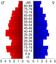
of 2000, there were 5,084 people, 2,046 households, and 1,438 families residing in the county. The population density
Population density
Population density is a measurement of population per unit area or unit volume. It is frequently applied to living organisms, and particularly to humans...
was 20 people per square mile (8/km²). There were 2,681 housing units at an average density of 11 per square mile (4/km²). The racial makeup of the county was 98.80% White
Race (United States Census)
Race and ethnicity in the United States Census, as defined by the Federal Office of Management and Budget and the United States Census Bureau, are self-identification data items in which residents choose the race or races with which they most closely identify, and indicate whether or not they are...
, 0.04% Black
Race (United States Census)
Race and ethnicity in the United States Census, as defined by the Federal Office of Management and Budget and the United States Census Bureau, are self-identification data items in which residents choose the race or races with which they most closely identify, and indicate whether or not they are...
or African American
Race (United States Census)
Race and ethnicity in the United States Census, as defined by the Federal Office of Management and Budget and the United States Census Bureau, are self-identification data items in which residents choose the race or races with which they most closely identify, and indicate whether or not they are...
, 0.31% Native American
Race (United States Census)
Race and ethnicity in the United States Census, as defined by the Federal Office of Management and Budget and the United States Census Bureau, are self-identification data items in which residents choose the race or races with which they most closely identify, and indicate whether or not they are...
, 0.18% Asian
Race (United States Census)
Race and ethnicity in the United States Census, as defined by the Federal Office of Management and Budget and the United States Census Bureau, are self-identification data items in which residents choose the race or races with which they most closely identify, and indicate whether or not they are...
, 0.16% from other races
Race (United States Census)
Race and ethnicity in the United States Census, as defined by the Federal Office of Management and Budget and the United States Census Bureau, are self-identification data items in which residents choose the race or races with which they most closely identify, and indicate whether or not they are...
, and 0.51% from two or more races. 0.63% of the population were Hispanic
Race (United States Census)
Race and ethnicity in the United States Census, as defined by the Federal Office of Management and Budget and the United States Census Bureau, are self-identification data items in which residents choose the race or races with which they most closely identify, and indicate whether or not they are...
or Latino
Race (United States Census)
Race and ethnicity in the United States Census, as defined by the Federal Office of Management and Budget and the United States Census Bureau, are self-identification data items in which residents choose the race or races with which they most closely identify, and indicate whether or not they are...
of any race. 53.5% were of German
Germans
The Germans are a Germanic ethnic group native to Central Europe. The English term Germans has referred to the German-speaking population of the Holy Roman Empire since the Late Middle Ages....
, 13.5% American
United States
The United States of America is a federal constitutional republic comprising fifty states and a federal district...
, 6.3% Irish
Irish people
The Irish people are an ethnic group who originate in Ireland, an island in northwestern Europe. Ireland has been populated for around 9,000 years , with the Irish people's earliest ancestors recorded having legends of being descended from groups such as the Nemedians, Fomorians, Fir Bolg, Tuatha...
and 6.0% English
English people
The English are a nation and ethnic group native to England, who speak English. The English identity is of early mediaeval origin, when they were known in Old English as the Anglecynn. England is now a country of the United Kingdom, and the majority of English people in England are British Citizens...
ancestry according to Census 2000. 98.5% spoke English
English language
English is a West Germanic language that arose in the Anglo-Saxon kingdoms of England and spread into what was to become south-east Scotland under the influence of the Anglian medieval kingdom of Northumbria...
and 1.3% Spanish
Spanish language
Spanish , also known as Castilian , is a Romance language in the Ibero-Romance group that evolved from several languages and dialects in central-northern Iberia around the 9th century and gradually spread with the expansion of the Kingdom of Castile into central and southern Iberia during the...
as their first language.
There were 2,046 households out of which 29.00% had children under the age of 18 living with them, 60.80% were married couples
Marriage
Marriage is a social union or legal contract between people that creates kinship. It is an institution in which interpersonal relationships, usually intimate and sexual, are acknowledged in a variety of ways, depending on the culture or subculture in which it is found...
living together, 5.70% had a female householder with no husband present, and 29.70% were non-families. 26.50% of all households were made up of individuals and 14.40% had someone living alone who was 65 years of age or older. The average household size was 2.46 and the average family size was 2.98.
In the county the population was spread out with 22.90% under the age of 18, 7.60% from 18 to 24, 25.90% from 25 to 44, 24.40% from 45 to 64, and 19.20% who were 65 years of age or older. The median age was 40 years. For every 100 females there were 100.80 males. For every 100 females age 18 and over, there were 100.40 males.
The median income for a household in the county was $34,375, and the median income for a family was $43,107. Males had a median income of $32,281 versus $20,943 for females. The per capita income
Per capita income
Per capita income or income per person is a measure of mean income within an economic aggregate, such as a country or city. It is calculated by taking a measure of all sources of income in the aggregate and dividing it by the total population...
for the county was $16,785. About 7.30% of families and 9.00% of the population were below the poverty line, including 9.10% of those under age 18 and 9.80% of those age 65 or over.
Creditworthiness
According to the TransUnion credit bureau Calhoun County is the only county in the United States to have a 0% delinquency rate on both credit cards and mortgages as of October 2008.Climate and weather
In recent years, average temperatures in the county seat of Hardin have ranged from a low of 19 °F (-7.2 °C) in January to a high of 90 °F (32.2 °C) in July, although a record low of -24 °F was recorded in January 1979 and a record high of 116 °F (46.7 °C) was recorded in July 1954. Average monthly precipitation ranged from 2.01 inches (5.1 cm) in January to 4.1 inches (10.4 cm) in May.See also
- National Register of Historic Places listings in Calhoun County, Illinois