

Great River Road
Encyclopedia
The Great River Road is a collection of state, provincial, federal, and local roads which follow the course of the Mississippi River
through ten states of the United States
. They are Arkansas
, Illinois
, Iowa
, Kentucky
, Louisiana
, Minnesota
, Mississippi
, Missouri
, Tennessee
and Wisconsin
.
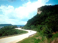 Although in a literal sense it is just a series of roads, the Great River Road is also a larger region inside the US and in each state. It is not a road in the sense of a local, state or national highway but the term is instead used for tourism and historic purposes. Some states have designated or identified regions of state interest along the road and use the roads to encompass those regions. The road travels through or near many natural and urban areas.
Divided into two main sections, the road consists of the Great River Road and the National Scenic Byway Route. The eponymous segment runs on both sides of the river from Louisiana through the state borders of Kentucky/Illinois and Missouri/Iowa, excepting the full length of the road in Arkansas. A five-state section of the road has been designated a National Scenic Byway
, running through Arkansas, Illinois, Iowa, Wisconsin, and Minnesota.
 Developed in 1938, the road has a separate commission in each state. These in turn cooperate through the Mississippi River Parkway Commission (MRPC). The 2,340 miles (3,765 km) are designated with a green-and-white sign showing a river steamboat inside a pilotwheel with the name of the state or province. The over-all logo reads "Canada to Gulf" where the local name would be, and most MRPC publications denote the route as beginning in Ontario and ending in Louisiana.
There are stretches of road designated Great River Road in each of the three central hydrographic basins of North America. The watershed, or river basin divide, between the Mississippi Basin Great River Road, and the Manitoba/Ontario Great River Road in the Hudson Bay Basin, lies about 50km south of a line between Warroad, Minnesota
, and International Falls, Minnesota
.
, Minnesota
. south to the mouths of the Mississippi River near Venice, Louisiana
. From Hastings, Minnesota
, south to Gretna, Louisiana
, the road runs along both banks of the Mississippi River.
Mississippi River
The Mississippi River is the largest river system in North America. Flowing entirely in the United States, this river rises in western Minnesota and meanders slowly southwards for to the Mississippi River Delta at the Gulf of Mexico. With its many tributaries, the Mississippi's watershed drains...
through ten states of the United States
United States
The United States of America is a federal constitutional republic comprising fifty states and a federal district...
. They are Arkansas
Arkansas
Arkansas is a state located in the southern region of the United States. Its name is an Algonquian name of the Quapaw Indians. Arkansas shares borders with six states , and its eastern border is largely defined by the Mississippi River...
, Illinois
Illinois
Illinois is the fifth-most populous state of the United States of America, and is often noted for being a microcosm of the entire country. With Chicago in the northeast, small industrial cities and great agricultural productivity in central and northern Illinois, and natural resources like coal,...
, Iowa
Iowa
Iowa is a state located in the Midwestern United States, an area often referred to as the "American Heartland". It derives its name from the Ioway people, one of the many American Indian tribes that occupied the state at the time of European exploration. Iowa was a part of the French colony of New...
, Kentucky
Kentucky
The Commonwealth of Kentucky is a state located in the East Central United States of America. As classified by the United States Census Bureau, Kentucky is a Southern state, more specifically in the East South Central region. Kentucky is one of four U.S. states constituted as a commonwealth...
, Louisiana
Louisiana
Louisiana is a state located in the southern region of the United States of America. Its capital is Baton Rouge and largest city is New Orleans. Louisiana is the only state in the U.S. with political subdivisions termed parishes, which are local governments equivalent to counties...
, Minnesota
Minnesota
Minnesota is a U.S. state located in the Midwestern United States. The twelfth largest state of the U.S., it is the twenty-first most populous, with 5.3 million residents. Minnesota was carved out of the eastern half of the Minnesota Territory and admitted to the Union as the thirty-second state...
, Mississippi
Mississippi
Mississippi is a U.S. state located in the Southern United States. Jackson is the state capital and largest city. The name of the state derives from the Mississippi River, which flows along its western boundary, whose name comes from the Ojibwe word misi-ziibi...
, Missouri
Missouri
Missouri is a US state located in the Midwestern United States, bordered by Iowa, Illinois, Kentucky, Tennessee, Arkansas, Oklahoma, Kansas and Nebraska. With a 2010 population of 5,988,927, Missouri is the 18th most populous state in the nation and the fifth most populous in the Midwest. It...
, Tennessee
Tennessee
Tennessee is a U.S. state located in the Southeastern United States. It has a population of 6,346,105, making it the nation's 17th-largest state by population, and covers , making it the 36th-largest by total land area...
and Wisconsin
Wisconsin
Wisconsin is a U.S. state located in the north-central United States and is part of the Midwest. It is bordered by Minnesota to the west, Iowa to the southwest, Illinois to the south, Lake Michigan to the east, Michigan to the northeast, and Lake Superior to the north. Wisconsin's capital is...
.
Divided into two main sections, the road consists of the Great River Road and the National Scenic Byway Route. The eponymous segment runs on both sides of the river from Louisiana through the state borders of Kentucky/Illinois and Missouri/Iowa, excepting the full length of the road in Arkansas. A five-state section of the road has been designated a National Scenic Byway
National Scenic Byway
A National Scenic Byway is a road recognized by the United States Department of Transportation for its archeological, cultural, historic, natural, recreational, and/or scenic qualities. The program was established by Congress in 1991 to preserve and protect the nation's scenic but often...
, running through Arkansas, Illinois, Iowa, Wisconsin, and Minnesota.
Routing
The Great River Road is not a single road as its name might suggest. It is more accurately described as a designated route, the whole of which consists of connected segments of other named and numbered highways and routes, each maintained by local jurisdictions.There are stretches of road designated Great River Road in each of the three central hydrographic basins of North America. The watershed, or river basin divide, between the Mississippi Basin Great River Road, and the Manitoba/Ontario Great River Road in the Hudson Bay Basin, lies about 50km south of a line between Warroad, Minnesota
Warroad, Minnesota
As of the census of 2000, there were 1,722 people, 657 households, and 419 families residing in the city. The population density was . There were 766 housing units at an average density of . The racial makeup of the city was 81.65% White, 0.29% Black or African American, 7.38% Native American,...
, and International Falls, Minnesota
International Falls, Minnesota
International Falls is a city in and the county seat of Koochiching County, Minnesota, United States. The population was 6,424 at the 2010 census....
.
In the Mississippi Basin
In the Mississippi Basin the Great River Road road runs from the traditional source of the Mississippi River in Lake ItascaLake Itasca
Lake Itasca is a small glacial lake, approximately in area, in the Headwaters area of north central Minnesota. The lake is located in southeastern Clearwater County within Itasca State Park and it has an average depth of 20–35 feet , and is 1,475 ft above sea level.The Ojibwe name for...
, Minnesota
Minnesota
Minnesota is a U.S. state located in the Midwestern United States. The twelfth largest state of the U.S., it is the twenty-first most populous, with 5.3 million residents. Minnesota was carved out of the eastern half of the Minnesota Territory and admitted to the Union as the thirty-second state...
. south to the mouths of the Mississippi River near Venice, Louisiana
Venice, Louisiana
Venice is an unincorporated community in Plaquemines Parish, Louisiana, United States. It is 130 km south of New Orleans on the west bank of the Mississippi River at . It is the last community down the Mississippi accessible by automobile, and is the southern terminus of the Great River Road...
. From Hastings, Minnesota
Hastings, Minnesota
Hastings is a city in Dakota counties in the U.S. state of Minnesota, near the confluence of the Mississippi and St. Croix Rivers. The population was 22,172 at the 2010 census. It is the county seat of Dakota County. The bulk of Hastings is in Dakota County; only a small part of the city extends...
, south to Gretna, Louisiana
Gretna, Louisiana
The city of Gretna is the parish seat of Jefferson Parish, in the US state of Louisiana. Gretna is on the west bank of the Mississippi River, just east and across the river from uptown New Orleans. It is part of the New Orleans–Metairie–Kenner Metropolitan Statistical Area...
, the road runs along both banks of the Mississippi River.
External links
- Mississippi River Parkway Commission
- River Roads
- Entry for the parts of the road in the National Scenic BywayNational Scenic BywayA National Scenic Byway is a road recognized by the United States Department of Transportation for its archeological, cultural, historic, natural, recreational, and/or scenic qualities. The program was established by Congress in 1991 to preserve and protect the nation's scenic but often...
system - Stories of St. Gabriel and the Great River Road in Louisiana, by J. Burton LeBlanc