

North Kent Marshes
Encyclopedia
Kent
Kent is a county in southeast England, and is one of the home counties. It borders East Sussex, Surrey and Greater London and has a defined boundary with Essex in the middle of the Thames Estuary. The ceremonial county boundaries of Kent include the shire county of Kent and the unitary borough of...
on the Thames Estuary
Thames Estuary
The Thames Mouth is the estuary in which the River Thames meets the waters of the North Sea.It is not easy to define the limits of the estuary, although physically the head of Sea Reach, near Canvey Island on the Essex shore is probably the western boundary...
in south-east England
England
England is a country that is part of the United Kingdom. It shares land borders with Scotland to the north and Wales to the west; the Irish Sea is to the north west, the Celtic Sea to the south west, with the North Sea to the east and the English Channel to the south separating it from continental...
, is one of 22 Environmentally Sensitive Area
Environmentally Sensitive Area
An Environmentally Sensitive Area is a type of designation for an agricultural area which needs special protection because of its landscape, wildlife or historical value. The scheme was introduced in 1987...
s recognised by the UK government's Department for Environment, Food and Rural Affairs
Department for Environment, Food and Rural Affairs
The Department for Environment, Food and Rural Affairs is the government department responsible for environmental protection, food production and standards, agriculture, fisheries and rural communities in the United Kingdom...
(DEFRA). It lies within the Thames Gateway
Thames Gateway
The Thames Gateway is an area of land stretching east from inner east London on both sides of the River Thames and the Thames Estuary. The area, which includes much brownfield land, has been designated a national priority for urban regeneration, taking advantage of the development opportunities...
regional planning area.
The north of Kent
Kent
Kent is a county in southeast England, and is one of the home counties. It borders East Sussex, Surrey and Greater London and has a defined boundary with Essex in the middle of the Thames Estuary. The ceremonial county boundaries of Kent include the shire county of Kent and the unitary borough of...
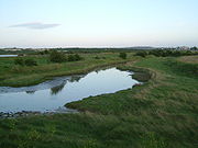
has historically been marshland and the part which still survives, stretching from Whitstable
Whitstable
Whitstable is a seaside town in Northeast Kent, Southeast England. It is approximately north of the city of Canterbury and approximately west of the seaside town of Herne Bay. It is part of the City of Canterbury district and has a population of about 30,000.Whitstable is famous for its oysters,...
to Dartford
Dartford
Dartford is the principal town in the borough of Dartford. It is situated in the northwest corner of Kent, England, east south-east of central London....
, has been recognised as one of the most important natural wetlands in northern Europe. The marshes offer invaluable natural flood protection for London
London
London is the capital city of :England and the :United Kingdom, the largest metropolitan area in the United Kingdom, and the largest urban zone in the European Union by most measures. Located on the River Thames, London has been a major settlement for two millennia, its history going back to its...
.
Monitored by local land owners and wildlife custodians, the RSPB claim up to 300,000 migrant birds use the mudflats of the Thames marshes as a regular haven in their migratory journeys between the Arctic
Arctic
The Arctic is a region located at the northern-most part of the Earth. The Arctic consists of the Arctic Ocean and parts of Canada, Russia, Greenland, the United States, Norway, Sweden, Finland, and Iceland. The Arctic region consists of a vast, ice-covered ocean, surrounded by treeless permafrost...
and Africa
Africa
Africa is the world's second largest and second most populous continent, after Asia. At about 30.2 million km² including adjacent islands, it covers 6% of the Earth's total surface area and 20.4% of the total land area...
.
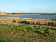
The RSPB have over recent years acquired considerable stretches of Cliffe marshes on the Hoo peninsula
Hoo Peninsula
The Hoo Peninsula is a peninsula in England separating the estuaries of the rivers Thames and Medway. It is dominated by a line of sand and clay hills, surrounded by an extensive area of marshland composed of alluvial silt. The name Hoo is the Old English word for spur of land.-History:The Romans...
. They maintain reserves at Cliffe pools, Northward hill, High Halstow
High Halstow
High Halstow is a village and civil parish on the Hoo Peninsula in the borough of Medway in northern Kent, England. The parish had a population of 1,781 according to the 2001 census....
and Elmley Marshes, Sheppey
Isle of Sheppey
The Isle of Sheppey is an island off the northern coast of Kent, England in the Thames Estuary, some to the east of London. It has an area of . The island forms part of the local government district of Swale...
. The Medway Council
Medway
Medway is a conurbation and unitary authority in South East England. The Unitary Authority was formed in 1998 when the City of Rochester-upon-Medway amalgamated with Gillingham Borough Council and part of Kent County Council to form Medway Council, a unitary authority independent of Kent County...
's Riverside park at Gillingham is another example of managed open public access to the marshes.
The North Kent Marsh with its stable water level is an important habitat for the water vole. There are thirteen key sites throughout Britain. Shorne
Shorne
Shorne is a village and civil parish in the Gravesham District of Kent, England. The parish is located to the south-east of Gravesend; the village is three miles from the town....
and Higham marshes, with parts of Cliffe and Cooling marsh, Allhallows and Grain
Isle of Grain
The Isle of Grain, in the north of Kent, England, is the easternmost point of the Hoo Peninsula. No longer an island, the Isle is almost all marshland and the Grain Marshes are an important habitat for birdlife...
marshes and the Isle of Sheppey
Isle of Sheppey
The Isle of Sheppey is an island off the northern coast of Kent, England in the Thames Estuary, some to the east of London. It has an area of . The island forms part of the local government district of Swale...
are among them.
The marshes are protected by the Kent and Medway Structure Plan, and a strong local environmental pressure group.
See also
- South SwaleSouth SwaleSouth Swale Local Nature Reserve is a Site of Special Scientific Interest and Ramsar Site between Faversham and Whitstable in southeast England. It consists of of the North Kent Marshes on the south bank of The Swale and along Faversham Creek...
- a nature reserve covering the marshes between Faversham and Whitstable