

Armero
Encyclopedia
Nevado del Ruiz
The Nevado del Ruiz, also known as La Mesa de Herveo or Kumanday in the language of the local pre-Columbian indigenous people, is a volcano located on the border of the departments of Caldas and Tolima in Colombia, about west of the capital city Bogotá. It is a stratovolcano, composed of many...
stratovolcano
Stratovolcano
A stratovolcano, also known as a composite volcano, is a tall, conical volcano built up by many layers of hardened lava, tephra, pumice, and volcanic ash. Unlike shield volcanoes, stratovolcanoes are characterized by a steep profile and periodic, explosive eruptions...
in Tolima, Colombia
Colombia
Colombia, officially the Republic of Colombia , is a unitary constitutional republic comprising thirty-two departments. The country is located in northwestern South America, bordered to the east by Venezuela and Brazil; to the south by Ecuador and Peru; to the north by the Caribbean Sea; to the...
on November 13, 1985. After 69 years of dormancy, the volcano's eruption caught nearby towns unaware, even though the government had received warnings to evacuate the area from multiple volcanological organizations when volcanic activity had been detected in September 1985.
As pyroclastic flows erupted from the volcano's crater
Volcanic crater
A volcanic crater is a circular depression in the ground caused by volcanic activity. It is typically a basin, circular in form within which occurs a vent from which magma erupts as gases, lava, and ejecta. A crater can be of large dimensions, and sometimes of great depth...
, they melted the mountain's glaciers, sending four enormous lahar
Lahar
A lahar is a type of mudflow or debris flow composed of a slurry of pyroclastic material, rocky debris, and water. The material flows down from a volcano, typically along a river valley. The term is a shortened version of "berlahar" which originated in the Javanese language of...
s (volcanically induced mudslides, landslide
Landslide
A landslide or landslip is a geological phenomenon which includes a wide range of ground movement, such as rockfalls, deep failure of slopes and shallow debris flows, which can occur in offshore, coastal and onshore environments...
s, and debris flow
Debris flow
A debris flow is a fast moving, liquefied landslide of unconsolidated, saturated debris that looks like flowing concrete. It is differentiated from a mudflow in terms of the viscosity and textural properties of the flow. Flows can carry material ranging in size from clay to boulders, and may...
s) down its slopes at 60 kilometres per hour (37.3 mph). The lahars picked up speed in gullies
Gully
A gully is a landform created by running water, eroding sharply into soil, typically on a hillside. Gullies resemble large ditches or small valleys, but are metres to tens of metres in depth and width...
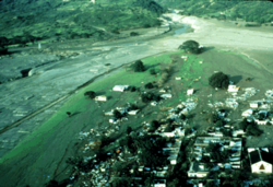
and coursed into the six major rivers at the base of the volcano; they engulfed the town of Armero
Armero
The Armero tragedy was one of the major consequences of the eruption of the Nevado del Ruiz stratovolcano in Tolima, Colombia on November 13, 1985...
, killing more than 20,000 of its almost 29,000 inhabitants. Casualties in other towns, particularly Chinchiná, brought the overall death toll to 23,000. Footage and photographs of Omayra Sánchez
Omayra Sánchez
Omaira Sánchez was a 13-year-old victim of the 1985 eruption of the Nevado del Ruiz volcano, which erupted on November 13, 1985, in Armero, Colombia causing massive lahars which killed nearly 25,000. Trapped for three days in water, concrete, and other debris before she died, Omayra captured the...
, a young victim of the tragedy
Tragedy (event)
A tragedy is an event in which one or more losses, usually of human life, occurs that is viewed as mournful. Such an event is said to be tragic....
, were published around the world. Other photographs of the lahars and the impact of the disaster captured attention worldwide and led to controversy over the degree to which the Colombian government was responsible for the disaster. A banner at a mass funeral in Ibague read, "The volcano didn't kill 22,000 people. The government killed them."
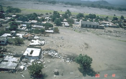
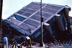
The relief efforts were hindered by the composition of the mud, which made it nearly impossible to move through without becoming stuck. By the time relief workers reached Armero twelve hours after the eruption, many of the victims with serious injuries were dead. The relief workers were horrified by the landscape of fallen trees, disfigured human bodies, and piles of debris from entire houses. This was the second-deadliest volcanic disaster of the 20th century, surpassed only by the 1902 eruption of Mount Pelée
Mount Pelée
Mount Pelée is an active volcano at the northern end of the island and French overseas department of Martinique in the Lesser Antilles island arc of the Caribbean. Its volcanic cone is composed of layers of volcanic ash and hardened lava....
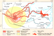
, and is the fourth-deadliest volcanic event recorded since 1500 AD. The event was a foreseeable catastrophe exacerbated by unawareness of the volcano's destructive history; geologists and other experts had warned authorities and media outlets about the danger over the weeks and days leading up to the eruption. Hazard map
Hazard map
A hazard map is a map that highlights areas that are affected or vulnerable of a particular hazard. They are typically created for natural hazards, such as earthquakes, volcanoes, landslides, flooding and tsunamis. Hazard maps help prevent serious damage and deaths....
s for the vicinity were prepared, but poorly distributed. On the day of the eruption, several evacuation attempts were made, but a severe storm restricted communications. Many victims stayed in their houses as they had been instructed, believing that the eruption had ended. The noise from the storm may have prevented many from hearing the sounds from Ruiz until it was too late.
Nevado del Ruiz has erupted several times since the disaster, and continues to threaten up to 500,000 people living along the Combeima, Chinchina, Coello-Toche, and Guali river valleys. A lahar (or group of lahars) similar in size to the 1985 event could potentially travel as far as 100 kilometres (62.1 mi) from the volcano, and could be triggered by a small eruption. To counter this threat, the Colombian government established a specialized office which promotes awareness of natural threats. The United States Geological Survey
United States Geological Survey
The United States Geological Survey is a scientific agency of the United States government. The scientists of the USGS study the landscape of the United States, its natural resources, and the natural hazards that threaten it. The organization has four major science disciplines, concerning biology,...
also created the Volcano Disaster Assistance Program
Volcano Disaster Assistance Program
The Volcano Disaster Assistance Program was developed by the U.S. Geological Survey and U.S. Office of Foreign Disaster Assistance after the eruption of Nevado del Ruiz in 1985 that killed 23,000 people...
and the Volcano Crisis Assistance Team, which evacuated roughly 75,000 people from the area around Mount Pinatubo
Mount Pinatubo
Mount Pinatubo is an active stratovolcano located on the island of Luzon, near the tripoint of the Philippine provinces of Zambales, Tarlac, and Pampanga. It is located in the Tri-Cabusilan Mountain range separating the west coast of Luzon from the central plains, and is west of the dormant and...
before its 1991 eruption. In 1988, three years after the eruption, Dr. Stanley Williams of Louisiana State University
Louisiana State University
Louisiana State University and Agricultural and Mechanical College, most often referred to as Louisiana State University, or LSU, is a public coeducational university located in Baton Rouge, Louisiana. The University was founded in 1853 in what is now known as Pineville, Louisiana, under the name...
stated that, "With the possible exception of Mount St. Helens
Mount St. Helens
Mount St. Helens is an active stratovolcano located in Skamania County, Washington, in the Pacific Northwest region of the United States. It is south of Seattle, Washington and northeast of Portland, Oregon. Mount St. Helens takes its English name from the British diplomat Lord St Helens, a...
in the state of Washington, no other volcano in the Western Hemisphere is being watched so elaborately" as Nevado del Ruiz. Additionally, many of Colombia's cities have programs to raise awareness of natural disaster planning programs which have helped save lives in natural disasters. Near Nevado del Ruiz in particular, locals have become wary of volcanic activity: when the volcano erupted in 1989, more than 2,300 people living around it were evacuated.
Background
Armero, located 48 kilometres (30 mi) from the Nevado del Ruiz volcano and 169 kilometres (105 mi) from Colombia's capital of BogotáBogotá
Bogotá, Distrito Capital , from 1991 to 2000 called Santa Fé de Bogotá, is the capital, and largest city, of Colombia. It is also designated by the national constitution as the capital of the department of Cundinamarca, even though the city of Bogotá now comprises an independent Capital district...
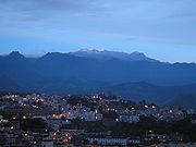
, was the third largest town in Tolima Department, after Ibague
Ibagué
Ibagué is the capital of the department of Tolima in Colombia. It is situated 1,285 m above sea level, on the eastern slopes of the Cordillera Central between the Chipalo and Combeima rivers, tributaries of the Coello River...
and Espinal
Espinal
Espinal is a town and municipality in the Tolima department of Colombia. The population of the municipality was 63,859 as of the 1993 census.The town is the seat of the Roman Catholic Diocese of Espinal....
. A prominent farming town before the eruption, it was responsible for roughly one-fifth of Colombia
Colombia
Colombia, officially the Republic of Colombia , is a unitary constitutional republic comprising thirty-two departments. The country is located in northwestern South America, bordered to the east by Venezuela and Brazil; to the south by Ecuador and Peru; to the north by the Caribbean Sea; to the...
's rice production, and for a large share of the cotton, sorghum
Sorghum
Sorghum is a genus of numerous species of grasses, one of which is raised for grain and many of which are used as fodder plants either cultivated or as part of pasture. The plants are cultivated in warmer climates worldwide. Species are native to tropical and subtropical regions of all continents...
, and coffee crops. Much of this success can be attributed to Nevado del Ruiz
Nevado del Ruiz
The Nevado del Ruiz, also known as La Mesa de Herveo or Kumanday in the language of the local pre-Columbian indigenous people, is a volcano located on the border of the departments of Caldas and Tolima in Colombia, about west of the capital city Bogotá. It is a stratovolcano, composed of many...
, as the fertile volcanic soil had stimulated agricultural growth. Built on top of an alluvial fan
Alluvial fan
An alluvial fan is a fan-shaped deposit formed where a fast flowing stream flattens, slows, and spreads typically at the exit of a canyon onto a flatter plain. A convergence of neighboring alluvial fans into a single apron of deposits against a slope is called a bajada, or compound alluvial...
that had been host to historic lahars, the town was previously destroyed by a volcanic eruption in 1595 and by mudflows in 1845. In the 1595 eruption, three distinct Plinian eruption
Plinian eruption
Plinian eruptions, also known as 'Vesuvian eruptions', are volcanic eruptions marked by their similarity to the eruption of Mount Vesuvius in AD 79 ....
s produced lahars that claimed the lives of 636 people. During the 1845 event, 1,000 people were killed by earthquake-generated mudflows near the Magdalena River
Magdalena River
The Magdalena River is the principal river of Colombia, flowing northward about through the western half of the country. It takes its name from the biblical figure Mary Magdalene. It is navigable through much of its lower reaches, in spite of the shifting sand bars at the mouth of its delta, as...
.
Nevado del Ruiz has undergone three distinct eruptive periods, the first beginning 1.8 million years ago. During the present period (beginning 11,000 years ago), it has erupted at least twelve times, producing ashfalls, pyroclastic flows, and lahars. The historically recorded eruptions have primarily involved a central vent eruption (in the caldera) followed by an explosive eruption, then the formation of lahar
Lahar
A lahar is a type of mudflow or debris flow composed of a slurry of pyroclastic material, rocky debris, and water. The material flows down from a volcano, typically along a river valley. The term is a shortened version of "berlahar" which originated in the Javanese language of...
s. Ruiz's earliest identified Holocene
Holocene
The Holocene is a geological epoch which began at the end of the Pleistocene and continues to the present. The Holocene is part of the Quaternary period. Its name comes from the Greek words and , meaning "entirely recent"...
eruption was in about 6660 BC, and further eruptions occurred around 1245, 850, 200 BC and in about 350, 675, in 1350, 1541 (perhaps), 1570, 1595, 1623, 1805, 1826, 1828 (perhaps), 1829, 1831, 1833 (perhaps), 1845, 1916, December 1984 through March 1985, 1987 through July 1991, and possibly in April 1994. Many of these eruptions involved a central vent eruption, a flank vent eruption, and a phreatic (steam) explosion. Ruiz is the second-most active volcano in Colombia after Galeras
Galeras
Galeras is an Andean stratovolcano in the Colombian department of Nariño, near the departmental capital Pasto. Its summit rises above sea level. It has erupted frequently since the Spanish conquest, with its first historical eruption being recorded on December 7, 1580...
.
One week before the eruption, the Palace of Justice siege
Palace of Justice siege
The Palace of Justice siege was a 1985 attack against the Supreme Court of Colombia, in which members of the M-19 guerrilla group took over the Palace of Justice in Bogotá, Colombia, and held the Supreme Court hostage, intending to hold a trial against President Belisario Betancur...
took place. The assailants (M-19
19th of April Movement
The 19th of April Movement or M-19, was a Colombian guerrilla movement. After its demobilization it became a political party, the M-19 Democratic Alliance , or AD/M-19.The M-19 traced its origins to the allegedly fraudulent presidential elections of 19 April 1970...
guerrilla fighters) planned to hold a trial involving Colombian President Belisario Betancur
Belisario Betancur
Belisario Betancur Cuartas is a Colombian statesman, who as a member of the Colombian Conservative Party was President of Colombia from 1982 to 1986.- Biographic data :...
. He refused to participate and sent the national army into the building. The attackers were holding several hundred hostages, including the 24 Supreme Court justices and 20 other judges. In the ensuing battle between the two forces, more than 75 hostages died (including 11 judges). This disaster, coupled with the Armero tragedy, spurred the Colombian government to predict and prepare for a broad range of threats.
Precursor
In late 1984, geologists noticed that seismic activity in the area had begun to increase. Increased fumaroleFumarole
A fumarole is an opening in a planet's crust, often in the neighborhood of volcanoes, which emits steam and gases such as carbon dioxide, sulfur dioxide, hydrochloric acid, and hydrogen sulfide. The steam is created when superheated water turns to steam as its pressure drops when it emerges from...
activity, deposition of sulfur
Sulfur
Sulfur or sulphur is the chemical element with atomic number 16. In the periodic table it is represented by the symbol S. It is an abundant, multivalent non-metal. Under normal conditions, sulfur atoms form cyclic octatomic molecules with chemical formula S8. Elemental sulfur is a bright yellow...
on the summit of the volcano, and phreatic eruptions also alerted geologists to the possibility of an eruption. Phreatic events, when rising magma encounters water, continued well into September 1985 (one major event took place on September 11, 1985), shooting steam high into the air. Activity began to decline in October, probably because the new magma
Magma
Magma is a mixture of molten rock, volatiles and solids that is found beneath the surface of the Earth, and is expected to exist on other terrestrial planets. Besides molten rock, magma may also contain suspended crystals and dissolved gas and sometimes also gas bubbles. Magma often collects in...
had finished ascending into Nevado del Ruiz's volcanic edifice.
An Italian volcanological mission analyzed gas samples from fumaroles along the Arenas crater floor and found them to be a mixture of carbon dioxide
Carbon dioxide
Carbon dioxide is a naturally occurring chemical compound composed of two oxygen atoms covalently bonded to a single carbon atom...
and sulfur dioxide
Sulfur dioxide
Sulfur dioxide is the chemical compound with the formula . It is released by volcanoes and in various industrial processes. Since coal and petroleum often contain sulfur compounds, their combustion generates sulfur dioxide unless the sulfur compounds are removed before burning the fuel...
, indicating a direct release of magma into the surface environment. Publishing a report for officials on October 22, 1985, the scientists determined that the risk of lahars was unusually high. To prepare for the eruption, the report gave several simple preparedness techniques to local authorities. Another team gave the local officials seismographs, but no instructions on how to operate them.
Volcanic activity increased again in November 1985 as magma neared the surface. Increasing quantities of gases rich in sulfur dioxide and elemental sulfur began to appear in the volcano. The water content of the fumaroles' gases decreased, and water springs in the vicinity of Nevado del Ruiz became enriched with magnesium, calcium and potassium, leached from the magma. The thermodynamic equilibration
Thermodynamic equilibrium
In thermodynamics, a thermodynamic system is said to be in thermodynamic equilibrium when it is in thermal equilibrium, mechanical equilibrium, radiative equilibrium, and chemical equilibrium. The word equilibrium means a state of balance...
temperatures, corresponding to the chemical composition of the discharged gases, ranged from 200 to 600 °C (392 to 1,112 °F); this is a measure of the temperature at which the gases equilibrated within the volcano. The extensive degassing of the magma caused pressure to build up inside the volcano in the space above the magma, which eventually resulted in the explosive eruption.
Preparation and attempted evacuation
In September 1985, as earthquakes and phreatic eruptions rocked the area, local officials began planning for an evacuation. In October, a hazard map was finalized for the area around Nevado del Ruiz. This map highlighted the danger from falling material—including ash and rockVolcanic rock
Volcanic rock is a rock formed from magma erupted from a volcano. In other words, it is an igneous rock of volcanic origin...
—near Murillo
Murillo, Tolima
Murillo is a town and municipality in the Tolima department of Colombia. The population of the municipality was 5,460 as of the 1993 census....
, Santa Isabel
Santa Isabel, Tolima
Santa Isabel is a town and municipality in the Tolima department of Colombia. The population of the municipality was 6,220 as of the 1993 census....
, and Libano
Líbano, Tolima
Líbano is a town and municipality in the Tolima department of Colombia. The population of the municipality was 39,785 as of the 1993 census. Along with Honda, Tolima, Líbano is the seat of the Roman Catholic Diocese of Líbano-Honda.-History:...
, as well as the threat of lahars in Mariquita, Guayabal, Chinchiná and Armero
Armero
The Armero tragedy was one of the major consequences of the eruption of the Nevado del Ruiz stratovolcano in Tolima, Colombia on November 13, 1985...
. Unfortunately, the map was poorly distributed to the people at high risk from Ruiz: many survivors had never heard of it, even though several of the country's major newspapers featured versions of the map. Henry Villegas of INGEOMINAS (Colombian Institute of Mining and Geology) stated that the hazard maps clearly demonstrated that Armero would be affected by the lahars, but that the map "met with strong opposition from economic interests." He added that because the map was not prepared long before the eruption, mass production and distribution of it in time was difficult.
El Espectador
El Espectador is a newspaper with national circulation within Colombia, founded by Fidel Cano Gutiérrez on 22 March 1887 in Medellín and published since 1915 in Bogotá...
newspaper in Bogotá included glaring errors. Without proper graphic scaling, it was unclear how big the map's hazard zones really were. The lahars on the map did not have a distinct ending point, and the main threat seemed to be from pyroclastic flows, not from mudflows. Though the map was colored blue, green, red, and yellow, there was no key to indicate what each color represented, and Armero was located in the green zone (believed to indicate the safest area). Another map published by the El Tiempo newspaper featured illustrations which "gave a perception of topography to the public unfamiliar with maps, allowing them to relate hazard zones to the landscape." In spite of this presentation that was keyed to the audience, the map ended up a more artistic representation of the risk than a purely scientific one.
The day of the eruption, black ash columns erupted from the volcano at approximately 3:00 pm local time. The local Civil Defense director was promptly alerted to the situation. He contacted INGEOMINAS, which ruled that the area should be evacuated; he was then told to contact the Civil Defense directors in Bogotá and Tolima. Between 5:00 and 7:00 pm, the ash stopped falling, and local officials instructed people to "stay calm" and go inside. Around 5:00 pm an emergency committee meeting was called, and when it ended at 7:00 pm, several members contacted the regional Red Cross over the intended evacuation efforts at Armero, Mariquita, and Honda. The Ibague Red Cross contacted Armero's officials and ordered an evacuation, which was not carried out because of electrical problems caused by a storm. The storm's heavy rain and constant thunder may have overpowered the noise of the volcano, and with no systematic warning efforts, the residents of Armero were completely unaware of the continuing activity at Ruiz. At 9:45 pm, after the volcano had erupted, Civil Defense officials from Ibague and Murillo tried to warn Armero's officials, but could not make contact. Later they overheard conversations between individual officials of Armero and others; famously, a few heard the Mayor of Armero speaking on a ham radio, saying "that he did not think there was much danger," when he was overtaken by the lahar.
Eruption

Dacite
Dacite is an igneous, volcanic rock. It has an aphanitic to porphyritic texture and is intermediate in composition between andesite and rhyolite. The relative proportions of feldspars and quartz in dacite, and in many other volcanic rocks, are illustrated in the QAPF diagram...
tephra
Tephra
200px|thumb|right|Tephra horizons in south-central [[Iceland]]. The thick and light coloured layer at center of the photo is [[rhyolitic]] tephra from [[Hekla]]....
more than 30 kilometres (18.6 mi) into the atmosphere. The total mass of the erupted material (including magma) was 35 million metric tons only three percent of the amount that erupted from Mount St. Helens
Mount St. Helens
Mount St. Helens is an active stratovolcano located in Skamania County, Washington, in the Pacific Northwest region of the United States. It is south of Seattle, Washington and northeast of Portland, Oregon. Mount St. Helens takes its English name from the British diplomat Lord St Helens, a...
in 1980. The eruption reached 3 on the Volcanic Explosivity Index
Volcanic Explosivity Index
The Volcanic Explosivity Index was devised by Chris Newhall of the U.S. Geological Survey and Stephen Self at the University of Hawaii in 1982 to provide a relative measure of the explosiveness of volcanic eruptions....
. The mass of the ejected sulfur dioxide was about 700,000 metric tons, or about two percent of the mass of the erupted solid material, making the eruption unusually sulfur rich.
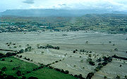
The eruption produced pyroclastic flows that melted summit glaciers and snow, generating four thick lahars that raced down river valleys on the volcano's flanks, destroying a small lake that was observed in Arenas' crater several months before the eruption. Water in such volcanic lakes tends to be extremely salty, and may contain dissolved volcanic gases. The lake's hot, acidic water significantly accelerated the melting of the ice, an effect confirmed by the large amounts of sulfate
Sulfate
In inorganic chemistry, a sulfate is a salt of sulfuric acid.-Chemical properties:...
s and chloride
Chloride
The chloride ion is formed when the element chlorine, a halogen, picks up one electron to form an anion Cl−. The salts of hydrochloric acid HCl contain chloride ions and can also be called chlorides. The chloride ion, and its salts such as sodium chloride, are very soluble in water...
s found in the lahar flow.
The lahars, formed of water, ice, pumice
Pumice
Pumice is a textural term for a volcanic rock that is a solidified frothy lava typically created when super-heated, highly pressurized rock is violently ejected from a volcano. It can be formed when lava and water are mixed. This unusual formation is due to the simultaneous actions of rapid...
, and other rocks, incorporated clay by eroding soil as they traveled down the volcano's flanks. They ran down the volcano's sides at an average speed of 60 kilometres (37.3 mi) per hour, dislodging rock and destroying vegetation. After descending thousands of meters down the side of the volcano, the lahars followed the six river valleys leading from the volcano, where they grew to almost four times their original volume. In the Gualí River, a lahar reached a maximum width of 50 metres (164 ft).
Survivors in Armero described the night as "quiet". Volcanic ash
Volcanic ash
Volcanic ash consists of small tephra, which are bits of pulverized rock and glass created by volcanic eruptions, less than in diameter. There are three mechanisms of volcanic ash formation: gas release under decompression causing magmatic eruptions; thermal contraction from chilling on contact...
had been falling throughout the day, but residents were informed it was nothing to worry about. Later in the afternoon, ash began falling again after a long period of quiet. Local radio stations reported that residents should remain calm and ignore the material. One survivor reported going to the fire department to be informed that the ash was "nothing".
During the night, the electrical power suddenly turned off and the radios went blank. Just before 11:30 pm, a huge stream of water swept through Armero; it was powerful enough to flip cars and pick up people. A loud roar could be heard from the mountain, but the residents were panicked over what they believed to be a flood.
Another lahar, which descended through the valley of the Chinchina River, killed about 1,800 people and destroyed 400 homes in Chinchina. In total, more than 23,000 people were killed, approximately 5,000 were injured, and 5,000 homes throughout thirteen villages were destroyed. Some 230,000 people were affected, 27000 acres (109.3 km²) were disrupted, and there were nearly 20,000 survivor-refugees. The Armero tragedy, as the event came to be known, was the second-deadliest volcanic disaster of the 20th century, surpassed only by the 1902 eruption of Mount Pelée
Mount Pelée
Mount Pelée is an active volcano at the northern end of the island and French overseas department of Martinique in the Lesser Antilles island arc of the Caribbean. Its volcanic cone is composed of layers of volcanic ash and hardened lava....
, and is the fourth-deadliest volcanic eruption recorded since 1500 AD. It is also the deadliest lahar, and Colombia's worst natural disaster.
Impact
Civil defense
Civil defense, civil defence or civil protection is an effort to protect the citizens of a state from military attack. It uses the principles of emergency operations: prevention, mitigation, preparation, response, or emergency evacuation, and recovery...
agencies for scaremongering. The eruption occurred at the height of guerrilla warfare in Bogotá
Bogotá
Bogotá, Distrito Capital , from 1991 to 2000 called Santa Fé de Bogotá, is the capital, and largest city, of Colombia. It is also designated by the national constitution as the capital of the department of Cundinamarca, even though the city of Bogotá now comprises an independent Capital district...
, Colombia's capital, and so the government and army were occupied at the time of the eruption.
The day after the eruption, relief workers were appalled at its impact. The lahars had left behind a gray mass which covered the entire town. Armero was dotted with broken trees and horribly disfigured human bodies. Debris from huts and homes protruded from beneath the gray mud. A few bags filled with crops were discovered in the mud. Workers described an acrid smell of "rotting bodies, [...] wood smoke and decaying vegetables." To the horror of these workers, who were scrambling to begin relief efforts, survivors let out moans of pain and agony. The damages were assessed at seven billion dollars, an amount approximately one-fifth of Colombia's 1985 Gross National Product.
As news of the catastrophe spread around the world, the ongoing presidential election stopped, and the guerrilla fighters stopped their campaign "in view of the painful tragedy that has befallen our [the Colombian fighters] nation." Tickets for Colombian national championship soccer games added a surcharge of five cents to go to relief efforts.
Scientists who later analyzed the seismograph data noticed that several long-period earthquakes (which begin strongly and then slowly die out) had occurred in the final hours before the eruption. Volcanologist Bernard Chouet said that, "the volcano was screaming 'I'm about to explode'", but the scientists who were studying the volcano at the time of the eruption were not able to read the signal.
Relief efforts
The eruption occurred at the same time as the 1985 Mexico City earthquake1985 Mexico City earthquake
The 1985 Mexico City earthquake, a magnitude 8.0 earthquake that struck Mexico City on the early morning of 19 September 1985 at around 7:19 AM , caused the deaths of at least 10,000 people and serious damage to the greater Mexico City Area. The complete seismic event...
, limiting the amount of supplies that could be sent to each of the disasters. Efforts were organized in Ibague and Bogotá for Armero and in Cali
Calì
Calì, also written in English as Cali, is an Italian surname, widespread mainly in the Ionian side of Sicily.For the surname Calì is assumed the origin of the Greek word kalos , or from its Sanskrit root kali, "time."The surname refers to:...
for Chinchina, where medical teams gathered. Makeshift triage
Triage
Triage or ) is the process of determining the priority of patients' treatments based on the severity of their condition. This rations patient treatment efficiently when resources are insufficient for all to be treated immediately. The term comes from the French verb trier, meaning to separate,...
stations were established in Lerida, Guayabal, and Mariquita, and soon were overwhelmed with the sheer number of victims. The remaining victims were directed to Ibague's hospitals, as local institutions had already been destroyed or were at risk from further lahars.
United States Geological Survey
The United States Geological Survey is a scientific agency of the United States government. The scientists of the USGS study the landscape of the United States, its natural resources, and the natural hazards that threaten it. The organization has four major science disciplines, concerning biology,...
(USGS), along with an AID disaster-relief expert and 12 helicopters with support and medical personnel from Panama
Panama
Panama , officially the Republic of Panama , is the southernmost country of Central America. Situated on the isthmus connecting North and South America, it is bordered by Costa Rica to the northwest, Colombia to the southeast, the Caribbean Sea to the north and the Pacific Ocean to the south. The...
. The US subsequently sent additional aircraft and supplies, including 500 tents, 2,250 blankets, and several tent repair kits. Twenty-four other nations contributed to the rescue and assistance of survivors. Ecuador supplied a mobile hospital, and Iceland's Red Cross sent $4,650. The French government sent their own medical supplies with 1,300 tents. Japan sent $1.25 million, along with eight doctors, nurses, and engineers, plus $50,000 to the United Nations for relief efforts. Another $50,000 was donated by the Lions Clubs International Foundation
Lions Clubs International
Lions Clubs International is a secular service organization with over 44,500 clubs and more than 1,368,683 members in 191 countries around the world founded by Melvin Jones Headquartered in Oak Brook, Illinois, United States, the organization aims to meet the needs of communities on a local and...
.
Rescue efforts were hindered by the soft mud that was up to 4.6 metres (15 ft) deep in some places, making it virtually impossible for anyone to transverse it without sinking in. To make the situation worse, the highway connected to Armero and several bridges to it had been demolished by the lahars. It took twelve hours for the first survivors to be rescued, so those with serious but treatable injuries probably died before the rescuers arrived. Because Armero's hospital was destroyed in the eruption, helicopters moved survivors to nearby hospitals. Six local towns set up makeshift emergency relief clinics, consisting of treatment areas and shelters for the homeless. To help with the treatment, physicians and rescue teams came from all over the country. Of the 1244 patients spread over the clinics, 150 died from infection or associated complications
Complication (medicine)
Complication, in medicine, is an unfavorable evolution of a disease, a health condition or a medical treatment. The disease can become worse in its severity or show a higher number of signs, symptoms or new pathological changes, become widespread throughout the body or affect other organ systems. A...
. Had antibiotics been readily available and all of their lacerations been thoroughly cleaned, many of these people could have been saved.
On November 20, 1985, one week later, rescue efforts began to cease. Nearly 4,000 relief workers and rescue team members were still searching for survivors, with little hope of finding any. By then, the official death toll was registered at 22,540 people; additional counts showed that 3,300 were missing, 20,000 homeless, and 4,000 injured. Looters raided the ruins and survivors faced concerns of typhus and yellow fever. For most of the relief workers, their job was over.
The eruption was used as an example for psychiatric recuperation after natural disasters by Robert Desjarlais and Leon Eisenberg in their work World Mental Health: Problems and Priorities in Low-Income Countries. The authors were concerned that only initial treatment for the survivors' trauma
Psychological trauma
Psychological trauma is a type of damage to the psyche that occurs as a result of a traumatic event...
was conducted. One study showed that the victims of the eruption suffered from anxiety and depression, which can lead to alcohol abuse, marital problems and other social issues. Rafael Ruiz, an Army Major who briefly served as Armero's provisional mayor after the disaster, stated that there were survivors who, due to the trauma of the event, were "jittery", experienced "nightmares", and suffered from "emotional problems." He added that the progress made by Christmas of 1985 was considerable, but that there was "still a long way to go."
Aftermath
A lack of preparation for the disaster contributed to the high death toll. Armero had been built on an alluvial fanAlluvial fan
An alluvial fan is a fan-shaped deposit formed where a fast flowing stream flattens, slows, and spreads typically at the exit of a canyon onto a flatter plain. A convergence of neighboring alluvial fans into a single apron of deposits against a slope is called a bajada, or compound alluvial...
that had been overrun by historic mudflows; authorities had ignored a hazard-zone map that showed the potential damage to the town from lahars. Residents stayed inside their dwellings to avoid the falling ash, as local officials had instructed them to do, not thinking that they might be buried by the mudflows.
The disaster gained international notoriety due in part to a photograph taken by photographer Frank Fournier of a young girl named Omayra Sánchez
Omayra Sánchez
Omaira Sánchez was a 13-year-old victim of the 1985 eruption of the Nevado del Ruiz volcano, which erupted on November 13, 1985, in Armero, Colombia causing massive lahars which killed nearly 25,000. Trapped for three days in water, concrete, and other debris before she died, Omayra captured the...
, who was trapped beneath rubble for three days before she died. Following the eruption relief workers gathered around the girl, speaking with her and listening to her responses. She attracted the attention of the reporters at the site because of her sense of dignity and courage, and caused controversy when people wondered why the media workers had not saved her (which was impossible without equipment). An appeal to the government for a pump to lower the water around her was left unanswered, and she succumbed to gangrene
Gangrene
Gangrene is a serious and potentially life-threatening condition that arises when a considerable mass of body tissue dies . This may occur after an injury or infection, or in people suffering from any chronic health problem affecting blood circulation. The primary cause of gangrene is reduced blood...
and hypothermia after 60 hours of being trapped. Her death epitomized the tragic nature of the Armero disaster – she could have been saved had the government responded promptly and addressed the concerns over the volcano's potency. The photograph earned the World Press Photo of the Year for "capturing the event of greatest journalistic importance".
Two photographers from the Miami Herald won a Pulitzer Prize
Pulitzer Prize
The Pulitzer Prize is a U.S. award for achievements in newspaper and online journalism, literature and musical composition. It was established by American publisher Joseph Pulitzer and is administered by Columbia University in New York City...
for photographing the effects of the lahar. Dr. Stanley Williams of Louisiana State University
Louisiana State University
Louisiana State University and Agricultural and Mechanical College, most often referred to as Louisiana State University, or LSU, is a public coeducational university located in Baton Rouge, Louisiana. The University was founded in 1853 in what is now known as Pineville, Louisiana, under the name...
said that following the eruption, "With the possible exception of Mount St. Helens in the state of Washington, no other volcano in the Western Hemisphere is being watched so elaborately." In response to the eruption, the USGS Volcano Crisis Assistance Team
Volcano Disaster Assistance Program
The Volcano Disaster Assistance Program was developed by the U.S. Geological Survey and U.S. Office of Foreign Disaster Assistance after the eruption of Nevado del Ruiz in 1985 that killed 23,000 people...
was formed in 1986, and the Volcano Disaster Assistance Program.
The volcano erupted several more times between 1985 and 1994.
Controversy
Concerns over the alleged negligence of local officials to alert locals of the volcano's threat led to controversy. The mayor of Armero (Ramon Rodriguez) and other local officials had tried to bring the volcano's potential to the attention of the Colombian government, but to no avail. For months, Rodriguez appealed to various officials, including congressmen and the Governor of Tolima Department. Rodriguez once referred to the volcano as a "time bomb" and told reporters that he believed an eruption would disrupt the natural dam above Armero, resulting in floods. Despite his persistence, only one congressman managed to inquire about the reality of the situation. Reports from the Colombian Minister of Mines, Minister of Defence, and Minister of Public Works "all asserted that the government was aware of the risk from the volcano and was acting to protect the population". The lack of responsibility for the disaster prompted lawmakers to campaign for Tolima's governor (Eduardo Alzate Garcia) to resign. In the media, similar thoughts and questions were hotly debated. One of the most aggressive campaigns came from a mass funeral in Ibague for the victims, claiming that "The volcano didn't kill 22,000 people. The government killed them."Legacy
Holocene glacial retreat
Holocene glacial retreat had a profound effect on landscapes in many areas that were covered by ice at the Last Glacial Maximum. The many valleys of the Cairngorms, a mountainous region in the Eastern Scottish Highlands are littered with deposits from this period.-Evidences of the retreat of the...
, a significant volume of ice still sits atop Nevado del Ruiz and other volcanoes in the Ruiz–Tolima massif. Melting just 10 percent of the ice would produce lahars with a volume of up to 200 million cubic meterssimilar to the lahar that destroyed Armero in 1985. In just hours, these lahars can travel up to 100 km along river valleys. Estimates show that up to 500,000 people living in the Combeima, Chinchina, Coello-Toche, and Guali valleys are at risk, with 100,000 individuals being considered to be at high risk. Lahars pose a threat to the nearby towns of Honda
Honda, Tolima
Honda is a town and municipality in the Tolima department of Colombia. The population of the municipality was 26,873 as of the 2005 census. Along with Líbano, Honda is the seat of the Roman Catholic Diocese of Líbano-Honda...
, Mariquita, Ambalema
Ambalema
Ambalema is a municipality in the Tolima department of Colombia. The population of Ambalema was 7,277 as of the 1993 census....
, Chinchina, Herveo
Herveo
Herveo is a town and municipality in the Tolima department of Colombia. The population of the municipality was 10,292 as of the 1993 census....
, Villa Hermosa
Villahermosa, Tolima
Villahermosa is a town and municipality in the Tolima department of Colombia. The population of the municipality was 12,574 as of the 1993 census. The municipality is also one of the most important coffee producers of Tolima's north....
, Salgar
Salgar
Salgar is a town and municipality in the Colombian department of Antioquia. Part of the subregion of Southwestern Antioquia....
and La Dorada
La Dorada, Caldas
La Dorada is a town and municipality in the Colombian Department of Caldas. It is the seat of the Roman Catholic Diocese of La Dorada–Guaduas. It is situated on the banks of Colombia's principal river, Magdalena River.-Gallery:-References:...
. Although small eruptions are more likely, the two-million-year eruptive history of the Ruiz–Tolima massif includes numerous large eruptions, indicating that the threat of a large eruption cannot be ignored. A large eruption would have more widespread effects, including the potential closure of Bogotá's airport
El Dorado International Airport
El Dorado International Airport is an international airport located in Bogotá, Colombia. It is the largest Latin America airport in terms of cargo movements with 593,946 tons and the third in terms of passenger traffic, only behind São Paulo-Guarulhos International Airport and Mexico City's...
due to ashfall.
As the Armero tragedy was exacerbated by the lack of early warnings, unwise land use, and the unpreparedness of nearby communities, the government of Colombia created a special program, the Oficina Nacional para la Atención de Desastres (National Office for Disaster Preparedness), now known as the Dirección de Prevención y Atención de Desastres (Directorate for Disaster Prevention and Preparedness) to prevent such incidents in the future. All Colombian cities were directed to promote prevention planning to mitigate the consequences of natural disasters, and evacuations due to volcanic hazards have been carried out. About 2,300 people living along five nearby rivers were evacuated when Nevado del Ruiz erupted again in 1989. When another Colombian volcano, Nevado del Huila
Nevado del Huila
Nevado del Huila , at , is the highest volcano in Colombia, located in Huila Department. After being dormant for more than 500 years, the volcano showed heavy signs of activity in 2007 and 2008. As of February 20, 2007, there were more than 7000 "minor" seismic events, and a high state of...
, erupted in April 2008, thousands of people were evacuated because volcanologists worried that the eruption could be another "Nevado del Ruiz".
The lessons from the Armero tragedy have inspired a lahar warning system for Mt. Rainier
Mount Rainier Volcano Lahar Warning System
The Mount Rainier Volcano Lahar Warning System is a loose-knit, emergency notification and warning system developed by the United States Geological Survey in 1998, and now operated by the Pierce County Department of Emergency Management and several cities...
, which has a similar potential for lahar
Lahar
A lahar is a type of mudflow or debris flow composed of a slurry of pyroclastic material, rocky debris, and water. The material flows down from a volcano, typically along a river valley. The term is a shortened version of "berlahar" which originated in the Javanese language of...
s.
Commemorations
A little less than one year later, Pope John Paul II flew over Armero and then visited Lérida'sLérida, Tolima
Lérida is a town and municipality in the Tolima department of Colombia. The population of the municipality was 20,153 as of the 1993 census....
refugee camps with Colombian President Belisario Betancur
Belisario Betancur
Belisario Betancur Cuartas is a Colombian statesman, who as a member of the Colombian Conservative Party was President of Colombia from 1982 to 1986.- Biographic data :...
. He spoke about the disaster and declared the site of Armero "holy land". Although many victims of the disaster were commemorated, Omayra Sanchez in particular was immortalized by poems, novels, and music pieces. One work (Adios, Omayra) by Eduardo Santa illustrated the girl's last days of life and her symbolism of the catastrophe. Survivors were also recognized in German Santamaria's dramatized television special titled "No Morirás" (You Will Not Die). Much of the cast was composed of victims of the tragedy who appeared at the cast calls to be extras.
External links
Armando Armero, website for the project to commemorate and remember Armero- Video about emergency response to the tragedy (15 minutes), Pan American Health OrganizationPan American Health OrganizationThe Pan American Health Organization is an international public health agency with over 100 years of experience working to improve health and living standards of the people of the Americas...
(hosted on YouTube) - Colombia's Mortal Agony (by George Russell), article from 2005 in TIME magazine
- Information about Armero (tripod.com) Text of the prayer made by Pope John Paul II in July 1986 at the memorial for the victims (Vatican website)
- Getty image of Pope John Paul II praying at the memorial (nhl.msg.com)
- Collection of photographs of the area and the memorials, from Luis Manuel Silva