
Holocene glacial retreat
Encyclopedia

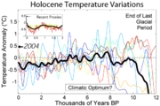
Holocene
The Holocene is a geological epoch which began at the end of the Pleistocene and continues to the present. The Holocene is part of the Quaternary period. Its name comes from the Greek words and , meaning "entirely recent"...
glacial retreat had a profound effect on landscapes in many areas that were covered by ice at the Last Glacial Maximum
Last Glacial Maximum
The Last Glacial Maximum refers to a period in the Earth's climate history when ice sheets were at their maximum extension, between 26,500 and 19,000–20,000 years ago, marking the peak of the last glacial period. During this time, vast ice sheets covered much of North America, northern Europe and...
. The many valleys of the Cairngorms
Cairngorms
The Cairngorms are a mountain range in the eastern Highlands of Scotland closely associated with the mountain of the same name - Cairn Gorm.-Name:...
, a mountainous region in the Eastern Scottish Highlands
Scottish Highlands
The Highlands is an historic region of Scotland. The area is sometimes referred to as the "Scottish Highlands". It was culturally distinguishable from the Lowlands from the later Middle Ages into the modern period, when Lowland Scots replaced Scottish Gaelic throughout most of the Lowlands...
are littered with deposits from this period.
Evidences of the retreat of the ice sheets

- Terminal moraineTerminal moraineA terminal moraine, also called end moraine, is a moraine that forms at the end of the glacier called the snout.Terminal moraines mark the maximum advance of the glacier. An end moraine is at the present boundary of the glacier....
- Altered river courses
The modern Ohio River
Ohio River
The Ohio River is the largest tributary, by volume, of the Mississippi River. At the confluence, the Ohio is even bigger than the Mississippi and, thus, is hydrologically the main stream of the whole river system, including the Allegheny River further upstream...
was formed when the river was temporarily dammed just southwest of Louisville, Kentucky
Louisville, Kentucky
Louisville is the largest city in the U.S. state of Kentucky, and the county seat of Jefferson County. Since 2003, the city's borders have been coterminous with those of the county because of a city-county merger. The city's population at the 2010 census was 741,096...
, creating a large lake until the dam burst. The Ohio River largely supplanted the former Teays River
Teays River
The Teays River was an important preglacial river that drained much of the area now drained by the Ohio River, and more. Traces of the Teays across northern Ohio and Indiana are represented by a network of river valleys. These valleys were carved in the late Cenozoic and eventually led to the...
drainage system, which was disrupted by the glaciers.
- Ancient shores
Ancient Lake Chicago
Lake Chicago
This article is about the prehistoric lake, For other geographic features with this name, see ChicagoLake Chicago was a prehistoric proglacial lake that is the ancestor of what is now known as Lake Michigan, one of North America's five Great Lakes....
, on the southern margin of the Wisconsin Glacier, found successive lower outlets as the glacier retreated, until the Saint Lawrence River
Saint Lawrence River
The Saint Lawrence is a large river flowing approximately from southwest to northeast in the middle latitudes of North America, connecting the Great Lakes with the Atlantic Ocean. It is the primary drainage conveyor of the Great Lakes Basin...
route was uncovered. Corresponding to each level, remnant lake shore features may be found in many areas. One prehistoric shoreline is delineated by Bluff Avenue, a north-south street on the La Grange, Illinois
La Grange, Illinois
La Grange, a suburb of Chicago, is a village in Cook County, in the U.S. state of Illinois. The population was 15,608 at the 2000 census.-History:...
east side.
Late Pleistocene - Holocene Marine Transgressions
The retreat and shrinking of Pleistocene ice sheets, ice caps, and mountain glaciers resulted in the addition of enormous quantities of water to the oceans and seas of the world. As result, sea level rose significantly globally resulting in extensive retreat of their shorelines around the world. In some areas, the sea level retreated inland rapidly as a result of rising sea level.The lower Tigris-Euphrates Valley, reflooding the Persian Gulf (12,000 years ago)
When sea levels were low, the combined TigrisTigris
The Tigris River is the eastern member of the two great rivers that define Mesopotamia, the other being the Euphrates. The river flows south from the mountains of southeastern Turkey through Iraq.-Geography:...
-Euphrates
Euphrates
The Euphrates is the longest and one of the most historically important rivers of Western Asia. Together with the Tigris, it is one of the two defining rivers of Mesopotamia...
river flowed through a wide flat marshy landscape. The Persian Gulf
Persian Gulf
The Persian Gulf, in Southwest Asia, is an extension of the Indian Ocean located between Iran and the Arabian Peninsula.The Persian Gulf was the focus of the 1980–1988 Iran-Iraq War, in which each side attacked the other's oil tankers...
today has an average depth of only 35 m. During the most recent glaciation, which ended 12,000 years ago, worldwide sea levels dropped 120 to 130 m (393.7 to 426.5 ft), leaving the bed of the Persian Gulf well above sea level
Sea level
Mean sea level is a measure of the average height of the ocean's surface ; used as a standard in reckoning land elevation...
during the glacial maximum. It had to have been a swampy freshwater floodplain, where water was retained in all the hollows. High in the Taurus Mountains
Taurus Mountains
Taurus Mountains are a mountain complex in southern Turkey, dividing the Mediterranean coastal region of southern Turkey from the central Anatolian Plateau. The system extends along a curve from Lake Eğirdir in the west to the upper reaches of the Euphrates and Tigris rivers in the east...
glaciation would have been extensive.
The drainage of the combined glacial era Tigris
Tigris
The Tigris River is the eastern member of the two great rivers that define Mesopotamia, the other being the Euphrates. The river flows south from the mountains of southeastern Turkey through Iraq.-Geography:...
-Euphrates
Euphrates
The Euphrates is the longest and one of the most historically important rivers of Western Asia. Together with the Tigris, it is one of the two defining rivers of Mesopotamia...
made its way down the marshes of this proto-Shatt-al-Arab to the Strait of Hormuz
Strait of Hormuz
The Strait of Hormuz is a narrow, strategically important waterway between the Gulf of Oman in the southeast and the Persian Gulf. On the north coast is Iran and on the south coast is the United Arab Emirates and Musandam, an exclave of Oman....
into the Arabian Sea
Arabian Sea
The Arabian Sea is a region of the Indian Ocean bounded on the east by India, on the north by Pakistan and Iran, on the west by the Arabian Peninsula, on the south, approximately, by a line between Cape Guardafui in northeastern Somalia and Kanyakumari in India...
. Reports of the exploration ship "Meteor" have confirmed that the Persian Gulf was an entirely dry basin about 15,000 BC. Close to the steeper Iranian side a deep channel apparently marks the course of the ancient extended Shatt al-Arab, being called the "Ur-Schatt". A continuous shallow shelf across the top (north) of the Persian Gulf and down the west side, at a 20 metres (65.6 ft) depth, suggests that this section was the last to be inundated. At the Straits of Hormuz the bathymetric profile indicates a division into two main channels which continue across the Bieban Shelf before dropping to a depth of approximately 400 metres (1,312.3 ft) in the Gulf of Oman
Gulf of Oman
The Gulf of Oman or Sea of Oman is a strait that connects the Arabian Sea with the Strait of Hormuz, which then runs to the Persian Gulf. It is generally included as a branch of the Persian Gulf, not as an arm of the Arabian Sea. On the north coast is Pakistan and Iran...
; the deeper parts of these channels may be due to delta deposits at the edge of the deep ocean collapsing in a succession of big underwater landslides, causing underwater erosion by the resulting turbidity current
Turbidity current
A turbidity current is a current of rapidly moving, sediment-laden water moving down a slope through water, or another fluid. The current moves because it has a higher density and turbidity than the fluid through which it flows...
s.
There is a theory that there was also a Black-Sea-type sill collapse at the Strait of Hormuz
Strait of Hormuz
The Strait of Hormuz is a narrow, strategically important waterway between the Gulf of Oman in the southeast and the Persian Gulf. On the north coast is Iran and on the south coast is the United Arab Emirates and Musandam, an exclave of Oman....
at the outlet of the Persian Gulf
Persian Gulf
The Persian Gulf, in Southwest Asia, is an extension of the Indian Ocean located between Iran and the Arabian Peninsula.The Persian Gulf was the focus of the 1980–1988 Iran-Iraq War, in which each side attacked the other's oil tankers...
.
In a 1981 Journal of Cuneiform Studies article, "The Tangible Evidence for the Earliest Dilmun", Theresa Howard-Carter espoused her theory identifying Dilmun
Dilmun
Dilmun or Telmun is a land mentioned by Mesopotamian civilizations as a trade partner, a source of the metal copper, and an entrepôt of the Mesopotamia-to-Indus Valley Civilization trade route...
with Qurna
Qurna
Qurna may refer to;* Kurna, three village areas near the Theban Hills in Egypt* al-Qurnah, a city in Iraq* Battle of Qurna, fought in, Qurna, Iraq* West Qurna Field, an oil field near Qurna, Iraq...
, an island at the Strait of Hormuz. Her scenario put the original mouths of the Tigris-Euphrates rivers, which she thought should be the site of the primeval Dilmun, at or even beyond the Straits of Hormuz. Mainstream archaeologists have avoided mentioning her article for fear of its apparent catastrophism
Catastrophism
Catastrophism is the theory that the Earth has been affected in the past by sudden, short-lived, violent events, possibly worldwide in scope. The dominant paradigm of modern geology is uniformitarianism , in which slow incremental changes, such as erosion, create the Earth's appearance...
, an awkward subject in geology. Theresa Howard-Carter also wrote: "It is more likely that the original Persian Gulf inhabitants lived along the banks of the lower or extended Shatt al-Arab, ranging some 800 km across the dry Persian Gulf bed. We can thus postulate that the pre-Sumerian cultures had more than ample time to be born and flourish in a riverine setting, encouraged by the agricultural potential and the blessings of a temperate climate. The fact that the body of proof for the existence of these societies must now lie at the bottom of the Persian Gulf furnishes at least a temporary excuse for the archaeologist's failure to produce evidence for their material culture."
In our time, mangrove
Mangrove
Mangroves are various kinds of trees up to medium height and shrubs that grow in saline coastal sediment habitats in the tropics and subtropics – mainly between latitudes N and S...
edge habitat and coral reef
Coral reef
Coral reefs are underwater structures made from calcium carbonate secreted by corals. Coral reefs are colonies of tiny living animals found in marine waters that contain few nutrients. Most coral reefs are built from stony corals, which in turn consist of polyps that cluster in groups. The polyps...
s encrustation of fossil dunes characterize the Persian Gulf. Mangroves recolonize easily from established mangrove fringe colonies elsewhere in the Arabian Sea. Artificial reefs are being established today along the coast of Iran. The present-day natural reef developments in the Persian Gulf, corals grow on hardground substrates but have not yet formed the massive calcium carbonate structures familiar from, say, Australia
Australia
Australia , officially the Commonwealth of Australia, is a country in the Southern Hemisphere comprising the mainland of the Australian continent, the island of Tasmania, and numerous smaller islands in the Indian and Pacific Oceans. It is the world's sixth-largest country by total area...
's Great Barrier Reef
Great Barrier Reef
The Great Barrier Reef is the world'slargest reef system composed of over 2,900 individual reefs and 900 islands stretching for over 2,600 kilometres over an area of approximately...
.
The article Dive conditions described by Eric Bjornstrom found in 1999 in Dubai
Dubai
Dubai is a city and emirate in the United Arab Emirates . The emirate is located south of the Persian Gulf on the Arabian Peninsula and has the largest population with the second-largest land territory by area of all the emirates, after Abu Dhabi...
coral-encrusted sand barrier islands situated 32 km off the coast of the Saudi city of Jubail
Jubail
Jubail , is a city in the Eastern province on the Persian Gulf coast of Saudi Arabia. It consists of the Old Town of Al Jubail, which was originally a small fishing village, up to 1975 and the new industrial area....
. There lies a chain of five coral cays, barely above the tide. They appear to be formations called diapirs in which a mobile core containing minerals of low density such as salt, deforms under pressure. The core pushes upwards, deforming overlying rock to form a dome. An ancient diapir at Enorama formed an island in shallow seas, buoyed up by salt. There are similar examples today in the Persian Gulf.
In addition to this large scale flooding of the Persian Gulf there is confirmed evidence of relatively recent extended local flooding in this part of the world. Excavations in Iraq, for example, have shown evidence of a flood at Shuruppak
Shuruppak
Shuruppak or Shuruppag was an ancient Sumerian city situated about 35 miles south of Nippur on the banks of the Euphrates at the site of modern Tell Fara in Iraq's Al-Qādisiyyah Governorate....
around 2900-2750 BCE which extended nearly as far as the city of Kish
Kish (Sumer)
Kish is modern Tell al-Uhaymir , and was an ancient city of Sumer. Kish is located some 12 km east of Babylon, and 80 km south of Baghdad ....
(whose king, Etana
Etana
Etana was an ancient, legendary Sumerian king of the city of Kish, and was, according to the Sumerian king list, one of the kings who reigned after the deluge. He is listed as the successor of Arwium, the son of Mashda, as king of Kish...
, supposedly founded the first Sumer
Sumer
Sumer was a civilization and historical region in southern Mesopotamia, modern Iraq during the Chalcolithic and Early Bronze Age....
ian dynasty after the Deluge). Sir C. Leonard Woolley’s excavations at Ur south of Uruk in the 1920s found a more than 2.5 metres (8.2 ft) thick homogeneous silty loam stratum that was void of artifacts, which Woolley in 1931 ascribed to Noah’s
Flood.
Persian Gulf (around 8,000 years ago)
An article published in Current Anthropology in 2010 revealed that a fertile landmass now submerged beneath the Persian Gulf may have been home to some of the earliest human populations outside Africa. Jeffrey Rose, an archaeologist and researcher with the University of Birmingham, says that the area in and around this "Persian GulfPersian Gulf
The Persian Gulf, in Southwest Asia, is an extension of the Indian Ocean located between Iran and the Arabian Peninsula.The Persian Gulf was the focus of the 1980–1988 Iran-Iraq War, in which each side attacked the other's oil tankers...
Oasis" may have been host to humans for over 100,000 years before it was swallowed up by the Indian Ocean
Indian Ocean
The Indian Ocean is the third largest of the world's oceanic divisions, covering approximately 20% of the water on the Earth's surface. It is bounded on the north by the Indian Subcontinent and Arabian Peninsula ; on the west by eastern Africa; on the east by Indochina, the Sunda Islands, and...
around 8,000 years ago. Archaeological sites in Yemen
Yemen
The Republic of Yemen , commonly known as Yemen , is a country located in the Middle East, occupying the southwestern to southern end of the Arabian Peninsula. It is bordered by Saudi Arabia to the north, the Red Sea to the west, and Oman to the east....
and Oman
Oman
Oman , officially called the Sultanate of Oman , is an Arab state in southwest Asia on the southeast coast of the Arabian Peninsula. It is bordered by the United Arab Emirates to the northwest, Saudi Arabia to the west, and Yemen to the southwest. The coast is formed by the Arabian Sea on the...
have yielded a stone tool style that is distinct from the East African tradition. This raises the possibility that humans were established on the southern part of the Arabian Peninsula beginning as far back as 100,000 years ago. The Persian Gulf links up Iran
Iran
Iran , officially the Islamic Republic of Iran , is a country in Southern and Western Asia. The name "Iran" has been in use natively since the Sassanian era and came into use internationally in 1935, before which the country was known to the Western world as Persia...
(ancient Persia), Saudi Arabia
Saudi Arabia
The Kingdom of Saudi Arabia , commonly known in British English as Saudi Arabia and in Arabic as as-Sa‘ūdiyyah , is the largest state in Western Asia by land area, constituting the bulk of the Arabian Peninsula, and the second-largest in the Arab World...
and Iraq
Iraq
Iraq ; officially the Republic of Iraq is a country in Western Asia spanning most of the northwestern end of the Zagros mountain range, the eastern part of the Syrian Desert and the northern part of the Arabian Desert....
(the ancient region of Southern Mesopotamia
Mesopotamia
Mesopotamia is a toponym for the area of the Tigris–Euphrates river system, largely corresponding to modern-day Iraq, northeastern Syria, southeastern Turkey and southwestern Iran.Widely considered to be the cradle of civilization, Bronze Age Mesopotamia included Sumer and the...
). A map published in the Journal "Current Anthropology" shows regions of the Arabian Peninsula that were exposed as sea levels fell, and hence supposes that people of that region became environmental refugee
Refugee
A refugee is a person who outside her country of origin or habitual residence because she has suffered persecution on account of race, religion, nationality, political opinion, or because she is a member of a persecuted 'social group'. Such a person may be referred to as an 'asylum seeker' until...
s around 8000 years ago.
The Carpentaria plain (12,000 to 10,000 years ago)
During glacial times, a stretch of level plain joined AustraliaAustralia
Australia , officially the Commonwealth of Australia, is a country in the Southern Hemisphere comprising the mainland of the Australian continent, the island of Tasmania, and numerous smaller islands in the Indian and Pacific Oceans. It is the world's sixth-largest country by total area...
with New Guinea
New Guinea
New Guinea is the world's second largest island, after Greenland, covering a land area of 786,000 km2. Located in the southwest Pacific Ocean, it lies geographically to the east of the Malay Archipelago, with which it is sometimes included as part of a greater Indo-Australian Archipelago...
and enabled humans to walk into Australia. That plain flooded to form the Gulf of Carpentaria
Gulf of Carpentaria
The Gulf of Carpentaria is a large, shallow sea enclosed on three sides by northern Australia and bounded on the north by the Arafura Sea...
around 12,000 to 10,000 years ago. Aboriginal Australian myth of the "dream time" includes a Great Flood which is not ordinarily a recognizable feature of the Australian climate and geography, except for infrequent filling of ordinarily dry lake basins (e.g. Lake Eyre
Lake Eyre
Lake Eyre is the lowest point in Australia, at approximately below sea level, and, on the rare occasions that it fills, it is the largest lake in Australia and 18th largest in the world...
).