

Amphoe Thai Mueang
Encyclopedia
Thai Mueang is a district (amphoe
) in the province Phang Nga
in the south of Thailand
.
, Kapong
, Mueang Phang Nga
and Takua Thung
. To the west is the Andaman Sea
.
The Khao Lampi - Hat Thai Mueang National Park was established in 1986 and covers 72 km². The park consists of two parts - the beach of Thai Mueang as well as the natural rain forest at Lampi mountain.
), which are further subdivided into 40 villages (muban
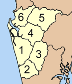
). Thai Mueang itself has township (thesaban tambon) status. There are 6 Tambon administrative organization (TAO).
Amphoe
An amphoe is the second level administrative subdivision of Thailand. Usually translated as district, amphoe make up the provinces, and are analogous to a county seat...
) in the province Phang Nga
Phang Nga Province
Phang Nga is one of the southern provinces of Thailand, on the shore to the Andaman Sea. Neighboring provinces are Ranong, Surat Thani and Krabi. To the south is the Phuket province, but without land boundary to Phang Nga....
in the south of Thailand
Thailand
Thailand , officially the Kingdom of Thailand , formerly known as Siam , is a country located at the centre of the Indochina peninsula and Southeast Asia. It is bordered to the north by Burma and Laos, to the east by Laos and Cambodia, to the south by the Gulf of Thailand and Malaysia, and to the...
.
Geography
Neighboring districts are (from the north clockwise) Takua PaAmphoe Takua Pa
Takua Pa ) is a district in the province Phang Nga in the south of Thailand.-Geography:The district is located at the coast to the Andaman Sea. To the north of the district is the Si Phang-nga National Park...
, Kapong
Amphoe Kapong
Kapong is a district in the province Phang Nga in the south of Thailand.-Geography:Neighboring districts are Phanom of Surat Thani Province, Mueang Phang Nga, Thai Mueang and Takua Pa....
, Mueang Phang Nga
Amphoe Mueang Phang Nga
Mueang Phang Nga is the capital district of Phang Nga Province in southern Thailand.-Geography:Neighboring districts are Thap Put, Phanom of Surat Thani Province, Kapong, Thai Mueang and Takua Thung. To the south is the Phang Nga bay, with the insular district Ko Yao.The Ao Phang Nga National...
and Takua Thung
Amphoe Takua Thung
Takua Thung is a district in the province Phang Nga in the south of Thailand.-History:Mueang Takua Thung is an ancient city same as Phang Nga and Takua Pa. The old city hall was located in Ban Khai, Tambon Bang Thong, Amphoe Thai Mueang. In 1894 Burmese troops attacked Mueang Takua Pa. Thalang...
. To the west is the Andaman Sea
Andaman Sea
The Andaman Sea or Burma Sea is a body of water to the southeast of the Bay of Bengal, south of Burma, west of Thailand and east of the Andaman Islands, India; it is part of the Indian Ocean....
.
The Khao Lampi - Hat Thai Mueang National Park was established in 1986 and covers 72 km². The park consists of two parts - the beach of Thai Mueang as well as the natural rain forest at Lampi mountain.
Administration
The district is subdivided into 6 subdistricts (tambonTambon
Tambon is a local government unit in Thailand. Below district and province , they form the third administrative subdivision level. As of the 2009 there are 7255 tambon, not including the 169 khwaeng of Bangkok, which are set at the same administrative level, thus every district contains 8-10 tambon...
), which are further subdivided into 40 villages (muban
Muban
Muban is the lowest administrative subdivision of Thailand. Usually translated as village, they are the subdivision of tambon. As of 2008, there are 74944 administrative villages in Thailand. As of the 1990 census, the average village consisted of 144 households or 746 persons.A muban does not...
). Thai Mueang itself has township (thesaban tambon) status. There are 6 Tambon administrative organization (TAO).
|
 |