
A10 road
Encyclopedia
The A10 is a major road
in England
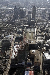
. Its southern end is at London Bridge
in the City of London
, and its northern end is the Norfolk
port town of King's Lynn
. From London to Royston
it chiefly follows the line of Roman Ermine Street
.


 Within the City of London
, the route of the A10 comprises King William Street
, Gracechurch Street
, Bishopsgate
and Norton Folgate
. It then becomes Shoreditch High Street
, Kingsland Road
, Kingsland High Street and Stoke Newington Road. It runs through Stoke Newington
as Stoke Newington High Street and then becomes Stamford Hill High Road until Tottenham
, where a gyratory system is in place.
North of Tottenham, the A10 leaves its historical route of Tottenham High Road
/Hertford Road (now A1010
) to join the Great Cambridge Road via Bruce Grove and The Roundway. The Roundway is the southern end of a long dual carriageway
section of the A10, which extends to just south of Buntingford
. This dual carriageway section bisects the London Borough of Enfield
, skirting the Enfield fringes of Enfield Town
before crossing the M25 motorway
at junction 25, near Waltham Cross
.
Until the late 1970s, the Great Cambridge Road passed through the towns of Broxbourne
, Hoddesdon
and Ware (along what is now the A1170 road). Since then, an all-purpose road—which diverges off the original dual carriageway at Cheshunt
—bypasses
these towns. The Kingsmead Viaduct
takes the A10 over the Lea Valley between Hertford
and Ware and the Hertford East Branch Line
railway.
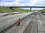
North of Ware, a further by-pass scheme was opened in late 2004, taking the A10 around the Hertfordshire
villages of Wadesmill
, Thundridge
, High Cross, and Collier's End. The bypass would have opened sooner, but the lime-stabilised subsoil heaved and cracks opened up in the road surface. A substantial portion of the road surface had to be relaid.
Further north, there is another section of 1970s dual carriageway road between Puckeridge
and Buntingford
, the contract for which was awarded to Meres Construction Ltd in April 1972. Buntingford
was by-passed in the 1980s, however this is only single carriageway
.
From Buntingford, the road runs through the villages of Chipping, Buckland, and Reed
, before reaching the edge of Hertfordshire in the market town of Royston
.
Once in Cambridgeshire, the topography changes from undulating hills to flat agricultural and fenlands, round the villages of Melbourn
and Foxton
(the road going over a level crossing
adjacent to Foxton railway station
), through Harston
and up to the M11 motorway
at junction 11, near Cambridge
. A10 traffic is signposted to travel north on the M11, skirting round the top of Cambridge on the A14; however, the former course of the A10 turns into the A1309
and heads for the city centre.
The A10 reappears to the north of Cambridge at the Milton
Interchange of the A14 and heads north, bypassing Ely
and Downham Market
before reaching the coast at King's Lynn
in Norfolk
. Its northern section runs along the valley of the River Great Ouse
(which meets A47 and A149).
as an urban dual carriageway, it is prone to traffic congestion
, in particular because of the many junctions with local roads. In the early 1990s properties beside the road were compulsorily purchased for a relief scheme that involved sinking the road below ground level through Cheshunt and converting the original alignment to single carriageway for local access. However, in the wake of protests
against a similar scheme in Wanstead
, this was dropped and the road remains a dual carriageway
, with surrounding houses having been sold back to private buyers.
Road
A road is a thoroughfare, route, or way on land between two places, which typically has been paved or otherwise improved to allow travel by some conveyance, including a horse, cart, or motor vehicle. Roads consist of one, or sometimes two, roadways each with one or more lanes and also any...
in England
England
England is a country that is part of the United Kingdom. It shares land borders with Scotland to the north and Wales to the west; the Irish Sea is to the north west, the Celtic Sea to the south west, with the North Sea to the east and the English Channel to the south separating it from continental...
. Its southern end is at London Bridge
London Bridge
London Bridge is a bridge over the River Thames, connecting the City of London and Southwark, in central London. Situated between Cannon Street Railway Bridge and Tower Bridge, it forms the western end of the Pool of London...
in the City of London
City of London
The City of London is a small area within Greater London, England. It is the historic core of London around which the modern conurbation grew and has held city status since time immemorial. The City’s boundaries have remained almost unchanged since the Middle Ages, and it is now only a tiny part of...
, and its northern end is the Norfolk
Norfolk
Norfolk is a low-lying county in the East of England. It has borders with Lincolnshire to the west, Cambridgeshire to the west and southwest and Suffolk to the south. Its northern and eastern boundaries are the North Sea coast and to the north-west the county is bordered by The Wash. The county...
port town of King's Lynn
King's Lynn
King's Lynn is a sea port and market town in the ceremonial county of Norfolk in the East of England. It is situated north of London and west of Norwich. The population of the town is 42,800....
. From London to Royston
Royston, Hertfordshire
Royston is a town and civil parish in the District of North Hertfordshire and county of Hertfordshire in England.It is situated on the Greenwich Meridian, which brushes the towns western boundary, and at the northernmost apex of the county on the same latitude of towns such as Milton Keynes and...
it chiefly follows the line of Roman Ermine Street
Ermine Street
Ermine Street is the name of a major Roman road in England that ran from London to Lincoln and York . The Old English name was 'Earninga Straete' , named after a tribe called the Earningas, who inhabited a district later known as Armingford Hundred, around Arrington, Cambridgeshire and Royston,...
.
Route
City of London
The City of London is a small area within Greater London, England. It is the historic core of London around which the modern conurbation grew and has held city status since time immemorial. The City’s boundaries have remained almost unchanged since the Middle Ages, and it is now only a tiny part of...
, the route of the A10 comprises King William Street
King William Street (London)
King William Street is the name of a street in the City of London, England. It runs from a junction at the Bank of England, meeting Poultry, Lombard Street and Threadneedle Street, south-east, where it meets a junction with Gracechurch and Cannon Street. It continues south after this junction, and...
, Gracechurch Street
Gracechurch Street
Gracechurch Street is a street in the City of London which forms part of the A10. It is home to a number of shops, restaurants, offices and Leadenhall Market....
, Bishopsgate
Bishopsgate
Bishopsgate is a road and ward in the northeast part of the City of London, extending north from Gracechurch Street to Norton Folgate. It is named after one of the original seven gates in London Wall...
and Norton Folgate
Norton Folgate
Norton Folgate is a short length of street in London, connecting Bishopsgate with Shoreditch High Street on the northern edge of its financial district, the City of London. It constitutes a very small section of the A10, the former Roman Ermine Street...
. It then becomes Shoreditch High Street
Shoreditch High Street
Shoreditch High Street is the old main street of Shoreditch, London. It is part of the A10 road and connects Norton Folgate to the south with Kingsland Road to the north. It constitutes a segment of the Roman Ermine Street, which ran directly north from London to Lincoln and York...
, Kingsland Road
Kingsland Road
Kingsland Road is the name of a road, part of the A10, in the London Borough of Hackney in England. It runs from the junction with Old Street and Hackney Road north to the junction with Balls Pond Road and Dalston Lane, where it changes its name to Kingsland High Street...
, Kingsland High Street and Stoke Newington Road. It runs through Stoke Newington
Stoke Newington
Stoke Newington is a district in the London Borough of Hackney. It is north-east of Charing Cross.-Boundaries:In modern terms, Stoke Newington can be roughly defined by the N16 postcode area . Its southern boundary with Dalston is quite ill-defined too...
as Stoke Newington High Street and then becomes Stamford Hill High Road until Tottenham
Tottenham
Tottenham is an area of the London Borough of Haringey, England, situated north north east of Charing Cross.-Toponymy:Tottenham is believed to have been named after Tota, a farmer, whose hamlet was mentioned in the Domesday Book; hence Tota's hamlet became Tottenham...
, where a gyratory system is in place.
North of Tottenham, the A10 leaves its historical route of Tottenham High Road
Tottenham High Road
Tottenham High Road is the main thoroughfare through the district of Tottenham, in the London Borough of Haringey. It runs from Edmonton in the North to Stamford Hill in the South . It follows, for the whole of its length, the course of the erstwhile Roman Road, Ermine Street...
/Hertford Road (now A1010
A1010 road
The A1010 is a road running through north London from Bruce Grove in Tottenham to Waltham Cross. It also used to continued north through Cheshunt to Turnford....
) to join the Great Cambridge Road via Bruce Grove and The Roundway. The Roundway is the southern end of a long dual carriageway
Dual carriageway
A dual carriageway is a class of highway with two carriageways for traffic travelling in opposite directions separated by a central reservation...
section of the A10, which extends to just south of Buntingford
Buntingford
Buntingford is a small market town and civil parish in the district of East Hertfordshire and county of Hertfordshire in England. It lies on the River Rib and on the Roman road Ermine Street. As a result of its location, it grew mainly as a staging post with many coaching inns and has an 18th...
. This dual carriageway section bisects the London Borough of Enfield
London Borough of Enfield
The London Borough of Enfield is the most northerly London borough and forms part of Outer London. It borders the London Boroughs of Barnet, Haringey and Waltham Forest...
, skirting the Enfield fringes of Enfield Town
Enfield Town
Enfield Town is the historic town centre of Enfield, formerly in the county of Middlesex and now in the London Borough of Enfield. It is north north-east of Charing Cross...
before crossing the M25 motorway
M25 motorway
The M25 motorway, or London Orbital, is a orbital motorway that almost encircles Greater London, England, in the United Kingdom. The motorway was first mooted early in the 20th century. A few sections, based on the now abandoned London Ringways plan, were constructed in the early 1970s and it ...
at junction 25, near Waltham Cross
Waltham Cross
Waltham Cross is the most southeasterly town in Hertfordshire, England. It is 12 miles from the City of London and immediately north of the M25 motorway, forming part of the Greater London Urban Area and London commuter belt. Part of Waltham Cross is located within Greater London.-Geography:It is...
.
Until the late 1970s, the Great Cambridge Road passed through the towns of Broxbourne
Broxbourne
Broxbourne is a commuter town in the Broxbourne borough of Hertfordshire in the East of England with a population of 13,298 in 2001.It is located 17.1 miles north north-east of Charing Cross in London and about a mile north of Wormley and south of Hoddesdon...
, Hoddesdon
Hoddesdon
Hoddesdon is a town in the English county of Hertfordshire, situated in the Lea Valley. The town grew up as a coaching stop on the route between Cambridge and London. It is located southeast of Hertford, north of Waltham Cross and southwest of Bishop's Stortford. At its height during the 18th...
and Ware (along what is now the A1170 road). Since then, an all-purpose road—which diverges off the original dual carriageway at Cheshunt
Cheshunt
Cheshunt is a town in Hertfordshire, England with a population of around 52,000 according to the United Kingdom's 2001 Census. It is a dormitory town and part of the Greater London Urban Area and London commuter belt served by Cheshunt railway station...
—bypasses
Bypass (road)
A bypass is a road or highway that avoids or "bypasses" a built-up area, town, or village, to let through traffic flow without interference from local traffic, to reduce congestion in the built-up area, and to improve road safety....
these towns. The Kingsmead Viaduct
Kingsmead Viaduct
The Kingsmead Viaduct is a raised dual-carriageway viaduct of the A10 road. It is often referred to colloquially as the Ware Viaduct....
takes the A10 over the Lea Valley between Hertford
Hertford
Hertford is the county town of Hertfordshire, England, and is also a civil parish in the East Hertfordshire district of the county. Forming a civil parish, the 2001 census put the population of Hertford at about 24,180. Recent estimates are that it is now around 28,000...
and Ware and the Hertford East Branch Line
Hertford East Branch Line
The Hertford East Branch Line is a railway line in Hertfordshire in the United Kingdom. It runs between and . The line follows the route of the Lea Valley; serving many towns and villages along the way...
railway.
North of Ware, a further by-pass scheme was opened in late 2004, taking the A10 around the Hertfordshire
Hertfordshire
Hertfordshire is a ceremonial and non-metropolitan county in the East region of England. The county town is Hertford.The county is one of the Home Counties and lies inland, bordered by Greater London , Buckinghamshire , Bedfordshire , Cambridgeshire and...
villages of Wadesmill
Wadesmill
Wadesmill is a hamlet in Hertfordshire, England, located on the north side of the River Rib with an estimated population of 264. Running through the center of Wadesmill is the road formerly known as the A10 - the main London to King's Lynn road - but now that the A10 by-pass has been built,...
, Thundridge
Thundridge
Thundridge is a village and civil parish in the East Hertfordshire District, in the county of Hertfordshire.- Location :It is about two miles away from the town of Ware and about seven miles away from the large town of Hertford - Nearby settlements :Nearby villages include Wadesmill and Tonwell,...
, High Cross, and Collier's End. The bypass would have opened sooner, but the lime-stabilised subsoil heaved and cracks opened up in the road surface. A substantial portion of the road surface had to be relaid.
Further north, there is another section of 1970s dual carriageway road between Puckeridge
Puckeridge
Puckeridge is a village in East Hertfordshire, England.The earliest settlers in the area were the Belgae, who arrived around 180 BC. A Roman town existed just to the north of the existing village and the village is at the cross roads of two major Roman roads, Ermine Street and Stane Street...
and Buntingford
Buntingford
Buntingford is a small market town and civil parish in the district of East Hertfordshire and county of Hertfordshire in England. It lies on the River Rib and on the Roman road Ermine Street. As a result of its location, it grew mainly as a staging post with many coaching inns and has an 18th...
, the contract for which was awarded to Meres Construction Ltd in April 1972. Buntingford
Buntingford
Buntingford is a small market town and civil parish in the district of East Hertfordshire and county of Hertfordshire in England. It lies on the River Rib and on the Roman road Ermine Street. As a result of its location, it grew mainly as a staging post with many coaching inns and has an 18th...
was by-passed in the 1980s, however this is only single carriageway
Single carriageway
A single carriageway is a road with 1, 2 or more lanes arranged within a single carriageway with no central reservation to separate opposing flows of traffic. Two-lane road or two-lane highway are single carriageway with one lane for each direction...
.
From Buntingford, the road runs through the villages of Chipping, Buckland, and Reed
Reed, Hertfordshire
Reed is a small village and civil parish in North Hertfordshire. It is situated on a chalk ridge at almost the highest point in the county, approximately 3 miles south of the market town of Royston. The Prime Meridian passes just to the east of the village, between Reed and Barkway...
, before reaching the edge of Hertfordshire in the market town of Royston
Royston, Hertfordshire
Royston is a town and civil parish in the District of North Hertfordshire and county of Hertfordshire in England.It is situated on the Greenwich Meridian, which brushes the towns western boundary, and at the northernmost apex of the county on the same latitude of towns such as Milton Keynes and...
.
Once in Cambridgeshire, the topography changes from undulating hills to flat agricultural and fenlands, round the villages of Melbourn
Melbourn
Melbourn is a large village in the far south west of Cambridgeshire, England. It is located next to the A10 just north of Royston. Melbourn has over 4,400 inhabitants...
and Foxton
Foxton, Cambridgeshire
Foxton is a small village in South Cambridgeshire, England. It has a number of well-preserved fifteenth and sixteenth century houses, and a thirteenth century church dedicated to St Lawrence.-History:...
(the road going over a level crossing
Level crossing
A level crossing occurs where a railway line is intersected by a road or path onone level, without recourse to a bridge or tunnel. It is a type of at-grade intersection. The term also applies when a light rail line with separate right-of-way or reserved track crosses a road in the same fashion...
adjacent to Foxton railway station
Foxton railway station
Foxton railway station serves the village of Foxton in Cambridgeshire, England. The station is operated by First Capital Connect....
), through Harston
Harston
Harston is a village to the south of Cambridge, England.-Harston House:Harston House is a historic private house in Harston. It was formerly known as Harston Hall....
and up to the M11 motorway
M11 motorway
The M11 motorway in England is a major road running approximately north from the North Circular Road in South Woodford in north-east London to the A14, north-west of Cambridge.-Route:...
at junction 11, near Cambridge
Cambridge
The city of Cambridge is a university town and the administrative centre of the county of Cambridgeshire, England. It lies in East Anglia about north of London. Cambridge is at the heart of the high-technology centre known as Silicon Fen – a play on Silicon Valley and the fens surrounding the...
. A10 traffic is signposted to travel north on the M11, skirting round the top of Cambridge on the A14; however, the former course of the A10 turns into the A1309
A1309 road
The A1309 is a short road which links the two ends of the A10 to north and south of Cambridge city centre in Cambridgeshire, England. It was numbered as part of the A10 prior to the construction of the Cambridge Western Bypass and the Northern Bypass .Its northern end is at the Milton Interchange...
and heads for the city centre.
The A10 reappears to the north of Cambridge at the Milton
Milton, Cambridgeshire
Milton is a village just north of Cambridge, England. It has a population of approximately 4,300 with 3,200 being on the electoral register. It expanded considerably in the late 1980s when two large housing estates were built between the bypass and the village resulting in a doubling of the...
Interchange of the A14 and heads north, bypassing Ely
Ely, Cambridgeshire
Ely is a cathedral city in Cambridgeshire, England, 14 miles north-northeast of Cambridge and about by road from London. It is built on a Lower Greensand island, which at a maximum elevation of is the highest land in the Fens...
and Downham Market
Downham Market
Downham Market is a town and civil parish in Norfolk, England. It lies on the edge of the Fens, on the River Great Ouse, some 20 km south of the town of King's Lynn, 60 km west of the city of Norwich and the same distance north of the city of Cambridge....
before reaching the coast at King's Lynn
King's Lynn
King's Lynn is a sea port and market town in the ceremonial county of Norfolk in the East of England. It is situated north of London and west of Norwich. The population of the town is 42,800....
in Norfolk
Norfolk
Norfolk is a low-lying county in the East of England. It has borders with Lincolnshire to the west, Cambridgeshire to the west and southwest and Suffolk to the south. Its northern and eastern boundaries are the North Sea coast and to the north-west the county is bordered by The Wash. The county...
. Its northern section runs along the valley of the River Great Ouse
River Great Ouse
The Great Ouse is a river in the east of England. At long, it is the fourth-longest river in the United Kingdom. The river has been important for navigation, and for draining the low-lying region through which it flows. Its course has been modified several times, with the first recorded being in...
(which meets A47 and A149).
Abandoned schemes
Where the A10 bisects CheshuntCheshunt
Cheshunt is a town in Hertfordshire, England with a population of around 52,000 according to the United Kingdom's 2001 Census. It is a dormitory town and part of the Greater London Urban Area and London commuter belt served by Cheshunt railway station...
as an urban dual carriageway, it is prone to traffic congestion
Traffic congestion
Traffic congestion is a condition on road networks that occurs as use increases, and is characterized by slower speeds, longer trip times, and increased vehicular queueing. The most common example is the physical use of roads by vehicles. When traffic demand is great enough that the interaction...
, in particular because of the many junctions with local roads. In the early 1990s properties beside the road were compulsorily purchased for a relief scheme that involved sinking the road below ground level through Cheshunt and converting the original alignment to single carriageway for local access. However, in the wake of protests
M11 link road protest
The M11 link road protest was a major anti-road protest in east London, United Kingdom, in the early 1990s opposing the construction of the "A12 Hackney to M11 link road", also known as the M11 Link Road...
against a similar scheme in Wanstead
Wanstead
Wanstead is a suburban area in the London Borough of Redbridge, North-East London. The main road going through Wanstead is the A12. The name is from the Anglo-Saxon words wænn and stede, meaning "settlement on a small hill"....
, this was dropped and the road remains a dual carriageway
Dual carriageway
A dual carriageway is a class of highway with two carriageways for traffic travelling in opposite directions separated by a central reservation...
, with surrounding houses having been sold back to private buyers.