
2009 North Indian Ocean cyclone season
Encyclopedia
The 2009 North Indian Ocean cyclone season was an event in the annual cycle of tropical cyclone
formation. The North Indian Ocean cyclone season has no official bounds, but cyclones tend to form between April and December, with peaks in May and November. These dates conventionally delimit the period of each year when most tropical cyclones form in the northern Indian Ocean
.
The scope of this article is limited to the Indian Ocean in the Northern Hemisphere
, east of the Horn of Africa
and west of the Malay Peninsula
. There are two main sea
s in the North Indian Ocean — the Arabian Sea
to the west of the Indian subcontinent
, abbreviated ARB by the India Meteorological Department
(IMD); and the Bay of Bengal
to the east, abbreviated BOB by the IMD.
The official Regional Specialized Meteorological Centre
in this basin is the India Meteorological Department
(IMD), while the Joint Typhoon Warning Center
releases unofficial advisories. The tropical cyclone scale
for this basin is detailed on the right. On average, 4 to 6 storms form in this basin every season.
became slightly organized over the central Bay of Bengal
. Later that day, an area of low pressure
developed underneath the convection as the system developed. Weak banding features
also formed around the periphery of the storm. By April 14, deep convection persisted around the center of circulation; following the development the RSMC in New Delhi, India designated the system as Depression BOB 01. Following further development, the Joint Typhoon Warning Center
(JTWC) issued a Tropical Cyclone Formation Alert
(TCFA) as they anticipated the system to develop into a tropical storm. Early the next morning the JTWC reported that the depression had intensified into a tropical storm and designated it as Cyclone 01B. The storm tracked towards the west-northwest due to a mid-level ridge
over India. Later that morning RSMC New Delhi reported that the depression had intensified into a deep depression and reported it was expected to intensify into Cyclonic Storm Bijli. Around 1500 UTC, the RSMC New Delhi upgraded the system to a cyclonic storm and gave it the name Bijli. All four ports in Orissa
were placed on high alert due to rough seas produced by the storm. A Local Cautionary Signal Number Three was issued for the Gopalpur, Puri, Paradeep and Chandabali
ports. On April 16, the storm turned towards the northeast, paralleling the eastern coast of India. Around 0600 UTC, RSMC New Delhi reported that Bijli had reached its peak intensity with winds of 75 km/h (45 mph 3-minute winds). Early on April 17, RSMC New Delhi reported that Bijli had weakened to a deep depression as it moved northwest. Later, RSMC New Delhi downgraded the deep depression to a depression. Late on April 17, RSMC New Delhi reported that Depression ex-Bijli had made landfall near Chittagong
, Bangladesh
and had rapidly become an area of low pressure over Bangladesh. That night, the JTWC issued their final advisory on Tropical Cyclone 01B as it rapidly weakened over Bangladesh and Myammar.
, India
. The disturbance at this time had a broad and poorly orgainsed area of deep convection, which was located to the southeast of the low level circulation center which had consolidated into a single circulation during the previous 12 hours. Environmental analysis indicated that the system was in an area of favorable conditions to develop with low vertical wind shear and warm sea surface temperatures. During May 22 the disturbance developed further with a Tropical Cyclone Formation Alert
being issued early the next day by the JTWC as the low level circulation center had become stronger and more defined. Later that morning RSMC New Delhi designated the disturbance as Depression BOB 02.
Unusually strong lightning storms associated with the depression killed at least nine people in Gujarat. Officials in the region warned residents about the likelihood of severe flooding from the depression. On June 23, upwards of 100 mm (3.9 in) fell in Gujarat prior to landfall.
, and intensified into Depression ARB 02. The storm moved northward, weakened, and maintained its intensity, as a well marked low pressure area over Kutch, and neighbouring areas at 0000 UTC on 26 June 2009. Saurashtra and Kutch experienced active monsoon condition under the influence of this system. Like its parent system, it was mostly monitored by the synoptic and satellite analysis. It was short lived system with a life period of about 25 hours. As a result it did not have any significant impact on rainfall, except over Saurashtra & Kutch.
Moving in a north-northwesterly direction, the Depression, which was located over Saurashtra, Kutch, and neighbouring areas, which was the system, re-intensified into the depression over northeast Arabian Sea, and lay centred near lat. 22.50N/long. 68.50E about 50 km west-northwest of Dwarka and 300 km south-southeast of Karachi at 0900 UTC on 25 June. Moving slowing in a northerly direction, the system weakened into a well marked low pressure area at 0000 UTC on 26 June, over Kutch and its neighbouring regions.
As those places were under the influence of the system, heavy to very heavy rainfall occurred at isolated places Saurashtra & Kutch and isolated heavy rainfall occurred over Gujarat region. But later on June 26, Depression ARB 02 dissipated completely.
The remnants of this storm caused heavy to very heavy downpour in coastal Pakistan
.
in West Bengal
and was expected to dissipate later that day. However the IMD kept issuing advisories on the deep depression until early on September 7, when the IMD reported that it had weakened into a depression and then into a well marked low pressure area later that day when they stopped issuing advisories on the depression whilst it was located over Jharkhand
and adjoining region of Chhattisgarh
.
One person drowned in Digha after being swept away by high waters. Rainfall from the storm was expected to peak near 250 mm (9.8 in); however, the highest recorded total only reached 76 mm (3 in).
Phyan as a tropical disturbance gave heavy rainfall to Tamil Nadu.Kethi in Nilgiris district of Tamil Nadu got 82 cm in 24 hours,beating the previous 24 hour rainfall record for Tamil Nadu.
, Sri Lanka
. The next day it strengthened to become Cyclonic Storm Ward. After wandering some time to the east of Sri Lanka
, the system made landfall near Trincomalee
on December 14 as a Deep Depression. Cyclonic Storm Ward dissipated completely on December 16.
, if any; the table does not include storms that did not make landfall, which is defined as the center of the storm moving over a landmass. Deaths in parentheses are additional and indirect (an example of an indirect death would be a traffic accident), but are still storm-related. Damage and deaths include totals while the storm was extratropical or a wave or low.
Tropical cyclone
A tropical cyclone is a storm system characterized by a large low-pressure center and numerous thunderstorms that produce strong winds and heavy rain. Tropical cyclones strengthen when water evaporated from the ocean is released as the saturated air rises, resulting in condensation of water vapor...
formation. The North Indian Ocean cyclone season has no official bounds, but cyclones tend to form between April and December, with peaks in May and November. These dates conventionally delimit the period of each year when most tropical cyclones form in the northern Indian Ocean
Indian Ocean
The Indian Ocean is the third largest of the world's oceanic divisions, covering approximately 20% of the water on the Earth's surface. It is bounded on the north by the Indian Subcontinent and Arabian Peninsula ; on the west by eastern Africa; on the east by Indochina, the Sunda Islands, and...
.
The scope of this article is limited to the Indian Ocean in the Northern Hemisphere
Northern Hemisphere
The Northern Hemisphere is the half of a planet that is north of its equator—the word hemisphere literally means “half sphere”. It is also that half of the celestial sphere north of the celestial equator...
, east of the Horn of Africa
Horn of Africa
The Horn of Africa is a peninsula in East Africa that juts hundreds of kilometers into the Arabian Sea and lies along the southern side of the Gulf of Aden. It is the easternmost projection of the African continent...
and west of the Malay Peninsula
Malay Peninsula
The Malay Peninsula or Thai-Malay Peninsula is a peninsula in Southeast Asia. The land mass runs approximately north-south and, at its terminus, is the southern-most point of the Asian mainland...
. There are two main sea
Sea
A sea generally refers to a large body of salt water, but the term is used in other contexts as well. Most commonly, it means a large expanse of saline water connected with an ocean, and is commonly used as a synonym for ocean...
s in the North Indian Ocean — the Arabian Sea
Arabian Sea
The Arabian Sea is a region of the Indian Ocean bounded on the east by India, on the north by Pakistan and Iran, on the west by the Arabian Peninsula, on the south, approximately, by a line between Cape Guardafui in northeastern Somalia and Kanyakumari in India...
to the west of the Indian subcontinent
Indian subcontinent
The Indian subcontinent, also Indian Subcontinent, Indo-Pak Subcontinent or South Asian Subcontinent is a region of the Asian continent on the Indian tectonic plate from the Hindu Kush or Hindu Koh, Himalayas and including the Kuen Lun and Karakoram ranges, forming a land mass which extends...
, abbreviated ARB by the India Meteorological Department
India Meteorological Department
The India Meteorological Department , also referred to as the Met Office, is an agency of the Ministry of Earth Sciences of the Government of India. It is the principal agency responsible for meteorological observations, weather forecasting and seismology...
(IMD); and the Bay of Bengal
Bay of Bengal
The Bay of Bengal , the largest bay in the world, forms the northeastern part of the Indian Ocean. It resembles a triangle in shape, and is bordered mostly by the Eastern Coast of India, southern coast of Bangladesh and Sri Lanka to the west and Burma and the Andaman and Nicobar Islands to the...
to the east, abbreviated BOB by the IMD.
The official Regional Specialized Meteorological Centre
Regional Specialized Meteorological Centre
A Regional Specialized Meteorological Centre is responsible for the distribution of information, advisories, and warnings regarding the specific program they have a part of, agreed by consensus at the World Meteorological Organization as part of the World Weather Watch.-Tropical...
in this basin is the India Meteorological Department
India Meteorological Department
The India Meteorological Department , also referred to as the Met Office, is an agency of the Ministry of Earth Sciences of the Government of India. It is the principal agency responsible for meteorological observations, weather forecasting and seismology...
(IMD), while the Joint Typhoon Warning Center
Joint Typhoon Warning Center
The Joint Typhoon Warning Center is a joint United States Navy – United States Air Force task force located at the Naval Maritime Forecast Center in Pearl Harbor, Hawaii...
releases unofficial advisories. The tropical cyclone scale
Tropical cyclone scales
Tropical systems are officially ranked on one of several tropical cyclone scales according to their maximum sustained winds and in what oceanic basin they are located...
for this basin is detailed on the right. On average, 4 to 6 storms form in this basin every season.
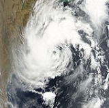
Cyclonic Storm Bijli
On April 13, an area of shower and thunderstormsAtmospheric convection
Atmospheric convection is the result of a parcel-environment instability, or temperature difference, layer in the atmosphere. Different lapse rates within dry and moist air lead to instability. Mixing of air during the day which expands the height of the planetary boundary layer leads to...
became slightly organized over the central Bay of Bengal
Bay of Bengal
The Bay of Bengal , the largest bay in the world, forms the northeastern part of the Indian Ocean. It resembles a triangle in shape, and is bordered mostly by the Eastern Coast of India, southern coast of Bangladesh and Sri Lanka to the west and Burma and the Andaman and Nicobar Islands to the...
. Later that day, an area of low pressure
Low pressure area
A low-pressure area, or "low", is a region where the atmospheric pressure at sea level is below that of surrounding locations. Low-pressure systems form under areas of wind divergence which occur in upper levels of the troposphere. The formation process of a low-pressure area is known as...
developed underneath the convection as the system developed. Weak banding features
Rainband
A rainband is a cloud and precipitation structure associated with an area of rainfall which is significantly elongated. Rainbands can be stratiform or convective, and are generated by differences in temperature. When noted on weather radar imagery, this precipitation elongation is referred to as...
also formed around the periphery of the storm. By April 14, deep convection persisted around the center of circulation; following the development the RSMC in New Delhi, India designated the system as Depression BOB 01. Following further development, the Joint Typhoon Warning Center
Joint Typhoon Warning Center
The Joint Typhoon Warning Center is a joint United States Navy – United States Air Force task force located at the Naval Maritime Forecast Center in Pearl Harbor, Hawaii...
(JTWC) issued a Tropical Cyclone Formation Alert
Tropical Cyclone Formation Alert
A Tropical Cyclone Formation Alert is a bulletin released by the U.S. Navy-operated Joint Typhoon Warning Center in Honolulu, Hawaii or the Naval Maritime Forecast Center in Norfolk, Virginia, warning of the possibility of a tropical cyclone forming from a tropical disturbance that has been...
(TCFA) as they anticipated the system to develop into a tropical storm. Early the next morning the JTWC reported that the depression had intensified into a tropical storm and designated it as Cyclone 01B. The storm tracked towards the west-northwest due to a mid-level ridge
High pressure area
A high-pressure area is a region where the atmospheric pressure at the surface of the planet is greater than its surrounding environment. Winds within high-pressure areas flow outward due to the higher density air near their center and friction with land...
over India. Later that morning RSMC New Delhi reported that the depression had intensified into a deep depression and reported it was expected to intensify into Cyclonic Storm Bijli. Around 1500 UTC, the RSMC New Delhi upgraded the system to a cyclonic storm and gave it the name Bijli. All four ports in Orissa
Orissa
Orissa , officially Odisha since Nov 2011, is a state of India, located on the east coast of India, by the Bay of Bengal. It is the modern name of the ancient nation of Kalinga, which was invaded by the Maurya Emperor Ashoka in 261 BC. The modern state of Orissa was established on 1 April...
were placed on high alert due to rough seas produced by the storm. A Local Cautionary Signal Number Three was issued for the Gopalpur, Puri, Paradeep and Chandabali
Chandabali
Chandabali is a community in the Bhadrak district of Orissa on the bank of the River Baitarani, and a tourist destination for visitors to the Bhitarkanika Wildlife Sanctuary.-History:...
ports. On April 16, the storm turned towards the northeast, paralleling the eastern coast of India. Around 0600 UTC, RSMC New Delhi reported that Bijli had reached its peak intensity with winds of 75 km/h (45 mph 3-minute winds). Early on April 17, RSMC New Delhi reported that Bijli had weakened to a deep depression as it moved northwest. Later, RSMC New Delhi downgraded the deep depression to a depression. Late on April 17, RSMC New Delhi reported that Depression ex-Bijli had made landfall near Chittagong
Chittagong
Chittagong ) is a city in southeastern Bangladesh and the capital of an eponymous district and division. Built on the banks of the Karnaphuli River, the city is home to Bangladesh's busiest seaport and has a population of over 4.5 million, making it the second largest city in the country.A trading...
, Bangladesh
Bangladesh
Bangladesh , officially the People's Republic of Bangladesh is a sovereign state located in South Asia. It is bordered by India on all sides except for a small border with Burma to the far southeast and by the Bay of Bengal to the south...
and had rapidly become an area of low pressure over Bangladesh. That night, the JTWC issued their final advisory on Tropical Cyclone 01B as it rapidly weakened over Bangladesh and Myammar.
Severe Cyclonic Storm Aila
Late on May 21, the JTWC reported that a Tropical Disturbance had persisted about 515 nm to the south of KolkataKolkata
Kolkata , formerly known as Calcutta, is the capital of the Indian state of West Bengal. Located on the east bank of the Hooghly River, it was the commercial capital of East India...
, India
India
India , officially the Republic of India , is a country in South Asia. It is the seventh-largest country by geographical area, the second-most populous country with over 1.2 billion people, and the most populous democracy in the world...
. The disturbance at this time had a broad and poorly orgainsed area of deep convection, which was located to the southeast of the low level circulation center which had consolidated into a single circulation during the previous 12 hours. Environmental analysis indicated that the system was in an area of favorable conditions to develop with low vertical wind shear and warm sea surface temperatures. During May 22 the disturbance developed further with a Tropical Cyclone Formation Alert
Tropical Cyclone Formation Alert
A Tropical Cyclone Formation Alert is a bulletin released by the U.S. Navy-operated Joint Typhoon Warning Center in Honolulu, Hawaii or the Naval Maritime Forecast Center in Norfolk, Virginia, warning of the possibility of a tropical cyclone forming from a tropical disturbance that has been...
being issued early the next day by the JTWC as the low level circulation center had become stronger and more defined. Later that morning RSMC New Delhi designated the disturbance as Depression BOB 02.
Depression ARB 01
Early on June 21, the JTWC reported that an area of low pressure had persisted about 675 km, (420 miles), southwest of Mumbai, India. Multispectral imagery showed that the disturbance had a developing low level circulation center with convection flaring over it and was in an area of low vertical wind shear. Over the next couple of days the disturbance developed gradually with a Tropical Cyclone Formation Alert being issued early on June 23 as the disturbance had continued to organize and consolidated over the last couple of hours. RSMC New Delhi then reported later that morning that Depression ARB 01 had formed and was expected to intensify into a Deep Depression before making landfall, however the depression did not intensify any further before making landfall on the south Gujarat coast later that afternoon. The JTWC then cancelled their Tropical Cyclone Formation Alert, with the IMD issuing their final advisory later that day. It hovered over Gujarat as a well marked area of low pressure before moving towards the northeast and re-emerged into the Arabian sea and regenerated into a Depression. Tropical Depression ARB 01 dissipated early on June 26.Unusually strong lightning storms associated with the depression killed at least nine people in Gujarat. Officials in the region warned residents about the likelihood of severe flooding from the depression. On June 23, upwards of 100 mm (3.9 in) fell in Gujarat prior to landfall.
Depression ARB 02
Early on June 25 at 0900 UTC, the remnants of Depression ARB 01 emerged into the Arabian SeaArabian Sea
The Arabian Sea is a region of the Indian Ocean bounded on the east by India, on the north by Pakistan and Iran, on the west by the Arabian Peninsula, on the south, approximately, by a line between Cape Guardafui in northeastern Somalia and Kanyakumari in India...
, and intensified into Depression ARB 02. The storm moved northward, weakened, and maintained its intensity, as a well marked low pressure area over Kutch, and neighbouring areas at 0000 UTC on 26 June 2009. Saurashtra and Kutch experienced active monsoon condition under the influence of this system. Like its parent system, it was mostly monitored by the synoptic and satellite analysis. It was short lived system with a life period of about 25 hours. As a result it did not have any significant impact on rainfall, except over Saurashtra & Kutch.
Moving in a north-northwesterly direction, the Depression, which was located over Saurashtra, Kutch, and neighbouring areas, which was the system, re-intensified into the depression over northeast Arabian Sea, and lay centred near lat. 22.50N/long. 68.50E about 50 km west-northwest of Dwarka and 300 km south-southeast of Karachi at 0900 UTC on 25 June. Moving slowing in a northerly direction, the system weakened into a well marked low pressure area at 0000 UTC on 26 June, over Kutch and its neighbouring regions.
As those places were under the influence of the system, heavy to very heavy rainfall occurred at isolated places Saurashtra & Kutch and isolated heavy rainfall occurred over Gujarat region. But later on June 26, Depression ARB 02 dissipated completely.
Deep Depression BOB 03
Early on July 20, RSMC New Delhi reported that Depression BOB 03 had formed about 120 km (75miles) to the southeast of Digha. Convection had been gradually organizing itself over the last 12 hours, and was in an area of low to moderate vertical wind shear. The Depression then intensified further and became a Deep Depression that afternoon before making landfall between the Orissa and West Bengal coast later that day. The Deep Depression gradually weakened before becoming a low pressure area early the next day.The remnants of this storm caused heavy to very heavy downpour in coastal Pakistan
Pakistan
Pakistan , officially the Islamic Republic of Pakistan is a sovereign state in South Asia. It has a coastline along the Arabian Sea and the Gulf of Oman in the south and is bordered by Afghanistan and Iran in the west, India in the east and China in the far northeast. In the north, Tajikistan...
.
Deep Depression BOB 04
Early on September 3, the IMD reported that an area of low pressure had formed embedded within the monsoon off the Orissa coastline. During the next day it developed further with the IMD reporting that the low pressure area had become well marked with deep convection starting to consolidate around a developing low level circulation center in an area of moderate vertical wind shear. Early on September 5, as the area of low pressure was moving into an area of low vertical windshear the JTWC issued a Tropical Cyclone Formation Alert, whilst the IMD reported that the low pressure area had intensified into a Depression. Later that day the IMD reported that the depression had intensified further and had become a Deep Depression, whilst the JTWC designated the depression as a Cyclone 03B, with winds equivalent to a tropical storm. However the JTWC's first warning was also their final warning as the cyclone had made landfall near DighaDigha
Digha is a seaside resort town in the state of West Bengal, India. It lies in East Midnapore district and at the northern end of the Bay of Bengal. It is the most popular sea resort in the West Bengal....
in West Bengal
West Bengal
West Bengal is a state in the eastern region of India and is the nation's fourth-most populous. It is also the seventh-most populous sub-national entity in the world, with over 91 million inhabitants. A major agricultural producer, West Bengal is the sixth-largest contributor to India's GDP...
and was expected to dissipate later that day. However the IMD kept issuing advisories on the deep depression until early on September 7, when the IMD reported that it had weakened into a depression and then into a well marked low pressure area later that day when they stopped issuing advisories on the depression whilst it was located over Jharkhand
Jharkhand
Jharkhand is a state in eastern India. It was carved out of the southern part of Bihar on 15 November 2000. Jharkhand shares its border with the states of Bihar to the north, Uttar Pradesh and Chhattisgarh to the west, Orissa to the south, and West Bengal to the east...
and adjoining region of Chhattisgarh
Chhattisgarh
Chhattisgarh is a state in Central India, formed when the 16 Chhattisgarhi-speaking South-Eastern districts of Madhya Pradesh gained separate statehood on 1 November 2000....
.
One person drowned in Digha after being swept away by high waters. Rainfall from the storm was expected to peak near 250 mm (9.8 in); however, the highest recorded total only reached 76 mm (3 in).
Cyclonic Storm Phyan
Cyclonic Storm Phyan developed as a tropical disturbance to the southwest of Colombo in Sri Lanka late on November 4, 2009. Over the next couple of days the disturbance gradually developed before weakening as it made landfall on Southern India on November 7. After the disturbance had emerged into the Arabian Sea late n November 8 it rapidly became more marked with the India Meteorological Department (IMD) reporting early on November 9 that the disturbance had intensified into a Depression and designated it as Depression ARB 03 whilst the Joint Typhoon Warning Center (JTWC) issued a Tropical Cyclone Formation Alert. Later that day the JTWC designated the system as Cyclone 04A. During the next day as the Depression turned towards the northeast the IMD reported that it had intensified into a Cyclonic Storm and named it as Phyan.Phyan as a tropical disturbance gave heavy rainfall to Tamil Nadu.Kethi in Nilgiris district of Tamil Nadu got 82 cm in 24 hours,beating the previous 24 hour rainfall record for Tamil Nadu.
Cyclonic Storm Ward
On December 10, RSMC New Delhi announced that Depression BOB 05 had formed, about 400 km east-southeast of BatticaloaBatticaloa
Batticaloa is a city in the Eastern province of Sri Lanka. It is the seat of the Eastern University of Sri Lanka. It is on the east coast, south by south east of Trincomalee, and is situated on an island.-Etymology:...
, Sri Lanka
Sri Lanka
Sri Lanka, officially the Democratic Socialist Republic of Sri Lanka is a country off the southern coast of the Indian subcontinent. Known until 1972 as Ceylon , Sri Lanka is an island surrounded by the Indian Ocean, the Gulf of Mannar and the Palk Strait, and lies in the vicinity of India and the...
. The next day it strengthened to become Cyclonic Storm Ward. After wandering some time to the east of Sri Lanka
Sri Lanka
Sri Lanka, officially the Democratic Socialist Republic of Sri Lanka is a country off the southern coast of the Indian subcontinent. Known until 1972 as Ceylon , Sri Lanka is an island surrounded by the Indian Ocean, the Gulf of Mannar and the Palk Strait, and lies in the vicinity of India and the...
, the system made landfall near Trincomalee
Trincomalee
Trincomalee is a port city in Eastern Province, Sri Lanka and lies on the east coast of the island, about 113 miles south of Jaffna. It has a population of approximately 100,000 . The city is built on a peninsula, which divides the inner and outer harbours. Overlooking the Kottiyar Bay,...
on December 14 as a Deep Depression. Cyclonic Storm Ward dissipated completely on December 16.
Season effects
This is a table of the storms in 2009 and their landfall(s)Landfall (meteorology)
Landfall is the event of a tropical cyclone or a waterspout coming onto land after being over water. When a waterspout makes landfall it is reclassified as a tornado, which can then cause damage inland...
, if any; the table does not include storms that did not make landfall, which is defined as the center of the storm moving over a landmass. Deaths in parentheses are additional and indirect (an example of an indirect death would be a traffic accident), but are still storm-related. Damage and deaths include totals while the storm was extratropical or a wave or low.
See also
- List of North Indian Ocean cyclone seasons
- 2009 Atlantic hurricane season2009 Atlantic hurricane seasonThe 2009 Atlantic hurricane season was a below-average year, unlike the 2009 Pacific hurricane season, which was above average, both due to a moderate El Niño. During this year, nine tropical storms formed, the fewest since the 1997 season.An average season has ten tropical storms, six hurricanes...
- 2009 Pacific hurricane season2009 Pacific hurricane seasonThe 2009 Pacific hurricane season was an active event in the annual cycle of tropical cyclone formation, due to a moderate El Niño, unlike the 2009 Atlantic hurricane season, which was relatively quiet. The season officially started on May 15 in the eastern Pacific, and on June 1 for the central...
- 2009 Pacific typhoon season2009 Pacific typhoon seasonThe 2009 Pacific typhoon season was the period that tropical cyclones formed in the Western Pacific Ocean. The season ran throughout the year during 2009, with most tropical cyclones forming between May and November. The scope of this article is limited to the Pacific Ocean, north of the equator...
- South-West Indian Ocean cyclone seasons: 2008-092008-09 South-West Indian Ocean cyclone seasonThe 2008–09 South-West Indian Ocean cyclone season was an event in the annual cycle of tropical cyclone formation. It began on November 15, 2008, and officially ended on April 30, 2009, with the exception for Mauritius and the Seychelles, for which it ended on May 15, 2009...
, 2009-10 - Australian region cyclone seasons: 2008-092008-09 Australian region cyclone seasonThe 2008–09 Australian region cyclone season was an event in the cycle of tropical cyclone formation. It officially started on 1 November 2008, and officially ended on 30 April 2009...
, 2009-10 - South Pacific cyclone seasons: 2008-092008-09 South Pacific cyclone seasonThe 2008–09 South Pacific cyclone season began on December 1, 2008 with the formation of Tropical Disturbance 01F. This was 30 days after the season had officially begun on November 1, 2008. The season officially ended on April 30, 2009. Tropical cyclones that were between 160°E and 120°W and north...
, 2009-10