
1972 Pacific hurricane season
Encyclopedia
The 1972 Pacific hurricane season was an ongoing event in tropical cyclone
meteorology. There were few notable storms this year. No one was killed and storm effects were generally not serious. The most notable systems were Hurricane Celeste and Joanne. Celeste was the strongest storm of the season, and caused heavy damage to Johnston Atoll. Hurricane Joanne brought gale force the Continental United States and caused flooding in Arizona
and northern Mexico
. The only other system to directly impact land was Hurricane Annette.
The season began on May 15, 1972 in the east Pacific
, and on June 1, 1972 in the central Pacific. It ended on November 30, 1972. These dates conventionally delimit the period of time when tropical cyclones form in the east Pacific Ocean. This season had a below average number of storms. There were twenty tropical cyclones, four of which were in the central Pacific. Of those, four were tropical storms, eight were hurricanes, and four were major hurricanes that reached Category 3 or higher on the Saffir-Simpson Hurricane Scale
. In the central Pacific, two tropical storms and two tropical depressions formed. One of the depressions and one of the storms crossed the dateline to become typhoons in the 1972 Pacific typhoon season
.
on June 7. The next day, it dissipated inland.
Annette brought several days of rainy weather to parts of Mexico. However, no deaths or damage were attributed to this tropical cyclone.
's area of responsibility
and entered the central Pacific. Celeste continued intensifying and eventually peaked as a Category 4 hurricane on the Saffir-Simpson Hurricane Scale. Celeste's Category 4 winds and central pressure of 940 millibars (840 hPa) made it the most intense cyclone of the season. After that, Celeste steadily weakened. After turning north, it dissipated on August 22 due wind shear
.
Celeste harassed several ships during its existence. The most serious incident involved a sailing vessel called the Regina Marina. On August 9, that ship was flooded and had to issue a distress call. It was spotted by a hurricane hunter and was reached and towed to safety by another ship, the Vishea Trith, and later on, the USCGC Mellon
. Two people aboard the Regina Marina were treated for injuries. Celeste passed close to Johnston Atoll
and was the first recorded hurricane to hit that island. Many buildings on the weather station
on the island lost roof tiles, and parts of most buildings were sandblasted by the wind. Celeste brought the highest recorded sustained winds in the station's thirteen years of operation, and the lowest barometric pressure ever recorded at Johnston at the time. A total of 6.21 inches (157.7 mm) of rain was recorded by a rain gauge
; this may be an underestimate due to the gauge's funnel being partly blocked by a lump of coral. Program 437
, an anti-satellite weapon
s system, was destroyed by the hurricane. On Johnston, no casualties were reported due to evacuations of the island's inhabitants. High waves also pounded the Puna, Kau, and South Kona Coasts of the Big Island
. An exact estimate of damage is not available.
At the time, Celeste was longest-lasting Pacific hurricane
with a lifespan of 16.25 days; that record was tied next season by Hurricane Doreen and outrun by Hurricane Fico in 1978. It remains the ninth-longest lasting Pacific hurricane, tied with 2005's Kenneth
and 1973's Doreen.
, Diana weakened into a tropical storm. On August 18, Diana turned to the northwest. It dissipated two days later.
Diana threatened the Hawaiian Islands enough to warrant the issuance of a tropical storm warning. Although it never made landfall, Diana dumped very heavy rain on the Big Island, though without flooding; the highest total was 10 inches (254 mm) somewhere northeast of Hilo. At Vacationland, surf swept four homes off their foundations, doing extensive damage to one of them. Another home was flooded. Debris was carried inland, and 200 feet (61 m) of private roads were washed away. The cost of damage to the extensively damaged house was $75,000 (1972 USD; $ USD), furnishings excluded.
became a tropical depression on August 15. It moved generally northwest. The depression strengthened into a tropical storm on August 16. Estelle continued to intensify, and became a hurricane on August 19. After peaking the next day, Estelle slowly weakened. It became a tropical storm on August 20 and dissipated two days later. Hurricane Estelle spent its entire life well away from inhabited land, and consequently caused no deaths or damage.
on September 1. A flash flood
on Waipio Stream in the Big Island's Kohala Mountains may have been due to Fernanda. Other than that, this tropical cyclone caused no known impact.
, but only the high surf materialized. Hurricane Gwen caused no deaths or damage.
organized into a tropical depression on August 28. It moved west for a day and then turned to the west northwest. It intensified into a tropical storm on August 29 and a hurricane the next day. Hyacinth peaked as a Category 3 major hurricane on August 31 through September 1. It then weakened. It also began to recurve to the north and then the northeast. Hyacinth reached its westernmost point on September 4 while a tropical storm. On September 6, it weakened into a tropical depression. It then made landfall north of San Diego, California
as a remnant low later that day, but it was nearly dissipated.
Hyacinth caused increased surf along the coast of California
, but was otherwise without serious effects. Tropical Depression Hyacinth's landfall was the first in California since 1939.
, a tropical depression formed on September 14. It paralleled the coast of Mexico until it strengthened into a tropical storm on September 16. Iva spent three days barely moving. On August 19, Iva got caught in the trade winds, headed westwards out to sea, and promptly weakened into a depression. By August 22 it was just a mass of clouds. Iva did not come near land and had no appreciable impact.
developed into a tropical depression on September 24 and a storm two days later. It never strengthened much, and rapidly weakened on September 28. Tropical Storm June passed southwest of Johnston Island on September 27, but was too feeble to cause damage, only bringing gusty breezes and some rain.
as a tropical storm. Joanne managed to retain a closed circulation and bring tropical storm force winds to Arizona, the first recorded time that had happened. The tropical storm dissipated inland over Sonora
on October 7. Joanne is one of only four known Pacific hurricanes to bring gale-force winds to the Continental United States, and was the first since the 1939 California tropical storm.
Heavy rainfall was reported throughout Arizona. Over 5 inches (127 mm) was measured at the Mogollon Rim
. There was severe flooding in the areas of Clifton
, Duncan
, and Safford
. Heavy rains were recorded elsewhere in the region. The highest total in Mexico was 9.45 in (240 mm) in San Felipe
/Mexicali
. Joanne caused heavy surf in California. No deaths were attributed to this tropical cyclone. An exact cost of damage is unknown.
as a tropical storm, Olga intensified into a typhoon on October 25. It then swung through part of the Northern Marianas Islands before it was absorbed by a front near Honshū on October 29. As the NMI had already been hit by Typhoon Marie three weeks earlier, little damage was reported.
. No deaths or damages were reported.
the next day. No deaths or damages were reported. Liza was a tropical storm for less than a day.
and 1996 seasons
for fewest tropical storms to form in July. It also shares the record for busiest November in the central Pacific with 1982 season
.
. No names were retired, so this list was used again in the 1976 season
.
The central Pacific used names and numbers from the west Pacific's typhoon list. Two names — June and Ruby — were required. Of the eleven hurricane seasons from 1970-81 where central Pacific cyclones were named using the west Pacific list, this is the first and only one to use multiple names.
Tropical cyclone
A tropical cyclone is a storm system characterized by a large low-pressure center and numerous thunderstorms that produce strong winds and heavy rain. Tropical cyclones strengthen when water evaporated from the ocean is released as the saturated air rises, resulting in condensation of water vapor...
meteorology. There were few notable storms this year. No one was killed and storm effects were generally not serious. The most notable systems were Hurricane Celeste and Joanne. Celeste was the strongest storm of the season, and caused heavy damage to Johnston Atoll. Hurricane Joanne brought gale force the Continental United States and caused flooding in Arizona
Arizona
Arizona ; is a state located in the southwestern region of the United States. It is also part of the western United States and the mountain west. The capital and largest city is Phoenix...
and northern Mexico
Mexico
The United Mexican States , commonly known as Mexico , is a federal constitutional republic in North America. It is bordered on the north by the United States; on the south and west by the Pacific Ocean; on the southeast by Guatemala, Belize, and the Caribbean Sea; and on the east by the Gulf of...
. The only other system to directly impact land was Hurricane Annette.
The season began on May 15, 1972 in the east Pacific
Pacific Ocean
The Pacific Ocean is the largest of the Earth's oceanic divisions. It extends from the Arctic in the north to the Southern Ocean in the south, bounded by Asia and Australia in the west, and the Americas in the east.At 165.2 million square kilometres in area, this largest division of the World...
, and on June 1, 1972 in the central Pacific. It ended on November 30, 1972. These dates conventionally delimit the period of time when tropical cyclones form in the east Pacific Ocean. This season had a below average number of storms. There were twenty tropical cyclones, four of which were in the central Pacific. Of those, four were tropical storms, eight were hurricanes, and four were major hurricanes that reached Category 3 or higher on the Saffir-Simpson Hurricane Scale
Saffir-Simpson Hurricane Scale
The Saffir–Simpson Hurricane Scale , or the Saffir–Simpson Hurricane Wind Scale , classifies hurricanes — Western Hemisphere tropical cyclones that exceed the intensities of tropical depressions and tropical storms — into five categories distinguished by the intensities of their sustained winds...
. In the central Pacific, two tropical storms and two tropical depressions formed. One of the depressions and one of the storms crossed the dateline to become typhoons in the 1972 Pacific typhoon season
1972 Pacific typhoon season
The 1972 Pacific typhoon season has no official bounds; it ran year-round in 1972, but most tropical cyclones tend to form in the northwestern Pacific Ocean between June and December...
.
Storms
Of this season's fourteen named tropical cyclones, twelve formed in the eastern Pacific and two in the central. Both central Pacific tropical cyclones were tropical storms. Of the eastern Pacific systems, four were tropical storms and eight were hurricanes. Of those eight hurricanes, four were major hurricanes because they peaked as Category 3 or higher on the Saffir-Simpson Hurricane Scale. These totals are below the long-term averages of fifteen named storms, nine hurricanes, and four major hurricanes. At the time, it was the central Pacific's busiest season.Hurricane Annette
On June 1, a tropical disturbance organized into a tropical storm. It slowly moved north and then recurved to the northeast as it accelerated slightly. It intensified into a hurricane on June 4. It remained at that strength for one day. Annette then began weakening. As a tropical storm, Annette made landfall in southeast of ManzanilloManzanillo, Colima
The name Manzanillo refers to the city as well as its surrounding municipality in the Mexican state of Colima. The city, located on the Pacific Ocean, contains Mexico's busiest port. Manzanillo was the third port created by the Spanish in the Pacific during the New Spain period...
on June 7. The next day, it dissipated inland.
Annette brought several days of rainy weather to parts of Mexico. However, no deaths or damage were attributed to this tropical cyclone.
Tropical Depression Two
Tropical Depression Two existed from June 27 to June 28. It paralleled the coast of Mexico without making landfall.Tropical Depression Three
Tropical Depression Three formed on July 4 and dissipated two days later. It moved westward while out to sea and never approached land.Tropical Storm Bonny
Only July 27, fifty days after the dissipation of Tropical Depression Annette, an area of clouds southwest of Manzanillo developed a closed circulation and became a tropical depression. The next day, it strengthened into a tropical storm. Heading generally west northwest, Bonny peaked in intensity on July 28. It weakened after that, and dissipated July 30. Bonny never came near land and caused no known impact.Hurricane Celeste
On August 6, a tropical disturbance developed into a tropical storm, skipping the depression stage. It edged south until August 8. At that point, it turned to the west. It would continue in that general direction until it dissipated. Celeste intensified into a hurricane on August 10. It then left the Eastern Pacific Hurricane CenterEastern Pacific Hurricane Center
The Eastern Pacific Hurricane Center was formerly the Regional Specialized Meteorological Center responsible for forecasting Pacific hurricanes in the eastern north Pacific east of 140°W...
's area of responsibility
Area of responsibility
Area Of Responsibility is a pre-defined geographic region assigned to a Combatant commanders of the Unified Command Plan , that are used to define an area with specific geographic boundaries where they have the authority to plan and conduct operations; for which a force, or component commander...
and entered the central Pacific. Celeste continued intensifying and eventually peaked as a Category 4 hurricane on the Saffir-Simpson Hurricane Scale. Celeste's Category 4 winds and central pressure of 940 millibars (840 hPa) made it the most intense cyclone of the season. After that, Celeste steadily weakened. After turning north, it dissipated on August 22 due wind shear
Wind shear
Wind shear, sometimes referred to as windshear or wind gradient, is a difference in wind speed and direction over a relatively short distance in the atmosphere...
.
Celeste harassed several ships during its existence. The most serious incident involved a sailing vessel called the Regina Marina. On August 9, that ship was flooded and had to issue a distress call. It was spotted by a hurricane hunter and was reached and towed to safety by another ship, the Vishea Trith, and later on, the USCGC Mellon
USCGC Mellon (WHEC-717)
USCGC Mellon is a U. S. Coast Guard high endurance cutter based out of Seattle, Washington. Laid down July 25, 1966 at Avondale Shipyards near New Orleans, Louisiana. Named for Andrew W. Mellon the 49th Secretary of the Treasury from 1921-1932 and launched February 11, 1967 by Mrs. John W. Warner,...
. Two people aboard the Regina Marina were treated for injuries. Celeste passed close to Johnston Atoll
Johnston Atoll
Johnston Atoll is a atoll in the North Pacific Ocean about west of Hawaii. There are four islands located on the coral reef platform, two natural islands, Johnston Island and Sand Island, which have been expanded by coral dredging, as well as North Island and East Island , an additional two...
and was the first recorded hurricane to hit that island. Many buildings on the weather station
Weather station
A weather station is a facility, either on land or sea, with instruments and equipment for observing atmospheric conditions to provide information for weather forecasts and to study the weather and climate. The measurements taken include temperature, barometric pressure, humidity, wind speed, wind...
on the island lost roof tiles, and parts of most buildings were sandblasted by the wind. Celeste brought the highest recorded sustained winds in the station's thirteen years of operation, and the lowest barometric pressure ever recorded at Johnston at the time. A total of 6.21 inches (157.7 mm) of rain was recorded by a rain gauge
Rain gauge
A rain gauge is a type of instrument used by meteorologists and hydrologists to gather and measure the amount of liquid precipitation over a set period of time....
; this may be an underestimate due to the gauge's funnel being partly blocked by a lump of coral. Program 437
Program 437
Program 437 was the second anti-satellite weapons program of the U.S. military. The US anti-satellite weapons program began development in the early 1960s and was officially discontinued on 1 April 1975. Program 437 was approved for development by U.S. Secretary of Defense Robert McNamara on...
, an anti-satellite weapon
Anti-satellite weapon
Anti-satellite weapons are designed to incapacitate or destroy satellites for strategic military purposes. Currently, only the United States, the former Soviet Union, and the People's Republic of China are known to have developed these weapons. On September 13, 1985, the United States destroyed US...
s system, was destroyed by the hurricane. On Johnston, no casualties were reported due to evacuations of the island's inhabitants. High waves also pounded the Puna, Kau, and South Kona Coasts of the Big Island
Hawaii (island)
The Island of Hawaii, also called the Big Island or Hawaii Island , is a volcanic island in the North Pacific Ocean...
. An exact estimate of damage is not available.
At the time, Celeste was longest-lasting Pacific hurricane
Pacific hurricane
A Pacific hurricane or tropical storm is a tropical cyclone that develops in the northeastern part of the Pacific Ocean. For organizational purposes, the northern Pacific Ocean is divided into three regions: the eastern, , central , and western...
with a lifespan of 16.25 days; that record was tied next season by Hurricane Doreen and outrun by Hurricane Fico in 1978. It remains the ninth-longest lasting Pacific hurricane, tied with 2005's Kenneth
Hurricane Kenneth (2005)
Hurricane Kenneth was the strongest and longest-tracked hurricane of the 2005 Pacific hurricane season. The eleventh named storm and fifth hurricane of the season, Kenneth developed from a disturbance in the Intertropical Convergence Zone to the southwest of Mexico on September 14...
and 1973's Doreen.
Hurricane Diana
On August 11, a tropical storm formed. It headed to the west northwest and strengthened into a hurricane on August 12. Diana then turned to the northwest, and peaked in intensity on August 1. It then headed west, and crossed into the central Pacific as a Category 1 hurricane. Shortly after crossing the basin boundary on a path directly towards the Hawaiian IslandsHawaiian Islands
The Hawaiian Islands are an archipelago of eight major islands, several atolls, numerous smaller islets, and undersea seamounts in the North Pacific Ocean, extending some 1,500 miles from the island of Hawaii in the south to northernmost Kure Atoll...
, Diana weakened into a tropical storm. On August 18, Diana turned to the northwest. It dissipated two days later.
Diana threatened the Hawaiian Islands enough to warrant the issuance of a tropical storm warning. Although it never made landfall, Diana dumped very heavy rain on the Big Island, though without flooding; the highest total was 10 inches (254 mm) somewhere northeast of Hilo. At Vacationland, surf swept four homes off their foundations, doing extensive damage to one of them. Another home was flooded. Debris was carried inland, and 200 feet (61 m) of private roads were washed away. The cost of damage to the extensively damaged house was $75,000 (1972 USD; $ USD), furnishings excluded.
Hurricane Estelle
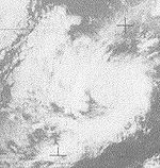
A swirl of thunderstorms near Clipperton IslandClipperton Island
Clipperton Island is an uninhabited nine-square-kilometre coral atoll in the eastern Pacific Ocean, southwest of Mexico and west of Central America, at...
became a tropical depression on August 15. It moved generally northwest. The depression strengthened into a tropical storm on August 16. Estelle continued to intensify, and became a hurricane on August 19. After peaking the next day, Estelle slowly weakened. It became a tropical storm on August 20 and dissipated two days later. Hurricane Estelle spent its entire life well away from inhabited land, and consequently caused no deaths or damage.
Hurricane Fernanda
An area of clouds south of Manzanillo developed into a tropical storm on August 20. It slowly strengthened, moving generally westnorthwest, and became a hurricane on August 22. It continued strengthening, and was briefly a Category 3 major hurricane on 24. Fernanda weakened after that, and it was a tropical storm by the time it crossed 140°W and entered the central Pacific. It remained at a steady intensity until it rapidly weakened when north of KauaiKauai
Kauai or Kauai, known as Tauai in the ancient Kaua'i dialect, is geologically the oldest of the main Hawaiian Islands. With an area of , it is the fourth largest of the main islands in the Hawaiian archipelago, and the 21st largest island in the United States. Known also as the "Garden Isle",...
on September 1. A flash flood
Flash flood
A flash flood is a rapid flooding of geomorphic low-lying areas—washes, rivers, dry lakes and basins. It may be caused by heavy rain associated with a storm, hurricane, or tropical storm or meltwater from ice or snow flowing over ice sheets or snowfields...
on Waipio Stream in the Big Island's Kohala Mountains may have been due to Fernanda. Other than that, this tropical cyclone caused no known impact.
Hurricane Gwen
On August 22, a tropical depression formed from a disturbance. It immediately strengthened into a storm and was named Gwen. Gwen moved generally northwest, paralleling the coast of Mexico, and intensified into a hurricane on August 24. It then spent a few days heading westnorthwest before resuming its original course. The hurricane became a major hurricane on August 27. After retaining that intensity for over a day, it rapidly weakened. Gwen became a tropical storm on August 29, weakened into a depression the next day, and dissipated just after that. Hurricane Gwen caused some concern for high surf in California, including a forecast for storm surgeStorm surge
A storm surge is an offshore rise of water associated with a low pressure weather system, typically tropical cyclones and strong extratropical cyclones. Storm surges are caused primarily by high winds pushing on the ocean's surface. The wind causes the water to pile up higher than the ordinary sea...
, but only the high surf materialized. Hurricane Gwen caused no deaths or damage.
Hurricane Hyacinth
A circulation south of the Gulf of TehuantepecGulf of Tehuantepec
Gulf of Tehuantepec is a large body of water on the Pacific coast of the Isthmus of Tehuantepec, southeastern Mexico, at . Most of the hurricanes that form in the Eastern Pacific organize in or near this body of water...
organized into a tropical depression on August 28. It moved west for a day and then turned to the west northwest. It intensified into a tropical storm on August 29 and a hurricane the next day. Hyacinth peaked as a Category 3 major hurricane on August 31 through September 1. It then weakened. It also began to recurve to the north and then the northeast. Hyacinth reached its westernmost point on September 4 while a tropical storm. On September 6, it weakened into a tropical depression. It then made landfall north of San Diego, California
San Diego, California
San Diego is the eighth-largest city in the United States and second-largest city in California. The city is located on the coast of the Pacific Ocean in Southern California, immediately adjacent to the Mexican border. The birthplace of California, San Diego is known for its mild year-round...
as a remnant low later that day, but it was nearly dissipated.
Hyacinth caused increased surf along the coast of California
California
California is a state located on the West Coast of the United States. It is by far the most populous U.S. state, and the third-largest by land area...
, but was otherwise without serious effects. Tropical Depression Hyacinth's landfall was the first in California since 1939.
Tropical Storm Iva
South of Salina CruzSalina Cruz
Salina Cruz is a major seaport on the Pacific coast of the Mexican state of Oaxaca. It is the state's third-largest city and is municipal seat of the municipality of the same name.It is part of the Tehuantepec District in the west of the Istmo Region....
, a tropical depression formed on September 14. It paralleled the coast of Mexico until it strengthened into a tropical storm on September 16. Iva spent three days barely moving. On August 19, Iva got caught in the trade winds, headed westwards out to sea, and promptly weakened into a depression. By August 22 it was just a mass of clouds. Iva did not come near land and had no appreciable impact.
Tropical Storm June
A northwestward-moving disturbance in the intertropical convergence zoneIntertropical Convergence Zone
The Intertropical Convergence Zone , known by sailors as The Doldrums, is the area encircling the earth near the equator where winds originating in the northern and southern hemispheres come together....
developed into a tropical depression on September 24 and a storm two days later. It never strengthened much, and rapidly weakened on September 28. Tropical Storm June passed southwest of Johnston Island on September 27, but was too feeble to cause damage, only bringing gusty breezes and some rain.
Tropical Depression of September 28 to October 3
A tropical depression formed September 28 east of the Hawaiian Islands. It headed towards the archipelago and dissipated on the afternoon of October 3. Later that day, its remnants dumped up to 10.5 in (266.7 mm) of rain on the mountains of the Big Island.Hurricane Joanne
A westward-moving area of squalls south of Mexico organized into a tropical depression on September 30. It then strengthened into a tropical storm and was named Joanne. Joanne moved west northwest, and intensified into a hurricane on October 1. It then peaked as a Category 2 hurricane on October 2. Joanne then slowed down and began to recurve, first to the north, and then the north northeast. While accelerating in that direction, Joanne made landfall near Laguna Chapala on the Baja California PeninsulaBaja California Peninsula
The Baja California peninsula , is a peninsula in northwestern Mexico. Its land mass separates the Pacific Ocean from the Gulf of California. The Peninsula extends from Mexicali, Baja California in the north to Cabo San Lucas, Baja California Sur in the south.The total area of the Baja California...
as a tropical storm. Joanne managed to retain a closed circulation and bring tropical storm force winds to Arizona, the first recorded time that had happened. The tropical storm dissipated inland over Sonora
Sonora
Sonora officially Estado Libre y Soberano de Sonora is one of the 31 states which, with the Federal District, comprise the 32 Federal Entities of Mexico. It is divided into 72 municipalities; the capital city is Hermosillo....
on October 7. Joanne is one of only four known Pacific hurricanes to bring gale-force winds to the Continental United States, and was the first since the 1939 California tropical storm.
Heavy rainfall was reported throughout Arizona. Over 5 inches (127 mm) was measured at the Mogollon Rim
Mogollon Rim
The Mogollon Rim is a topographical and geological feature running across the U.S. state of Arizona. It extends approximately from northern Yavapai County eastward to near the border with New Mexico.-Description:...
. There was severe flooding in the areas of Clifton
Clifton, Arizona
Clifton is a town in and the county seat of Greenlee County, Arizona, United States, along the San Francisco River. The population of the town was 3,311 at the 2010 census. It was a site of the Arizona Copper Mine Strike of 1983....
, Duncan
Duncan, Arizona
Duncan is a town in Greenlee County, Arizona, United States. According to 2006 Census Bureau estimates, the population of the town is 713. It is part of the Safford Micropolitan Statistical Area. Duncan is at the juncture of the Gila River and the Arizona-New Mexico state border...
, and Safford
Safford, Arizona
- History :Safford was founded by Joshua Eaton Bailey, Hiram Kennedy and Edward Tuttle, who came from Gila Bend, in southwestern Arizona. They left Gila Bend in the winter of 1873-74; their work on canals and dams having been destroyed by high water the previous summer...
. Heavy rains were recorded elsewhere in the region. The highest total in Mexico was 9.45 in (240 mm) in San Felipe
San Felipe, Baja California
San Felipe is a town on the Gulf of California in the Mexican state of Baja California, 190 km south of the United States border and within the municipality of Mexicali. It also serves as a borough seat of its surrouding area....
/Mexicali
Mexicali
Mexicali is the capital of the State of Baja California, seat of the Municipality of Mexicali, and 2nd largest city in Baja California. The City of Mexicali has a population of 689,775, according to the 2010 census, while the population of the entire metropolitan area reaches 936,826.The city...
. Joanne caused heavy surf in California. No deaths were attributed to this tropical cyclone. An exact cost of damage is unknown.
Tropical Depression Thirteen
Tropical Depression Thirteen formed on October 12. It first headed southwest, then west, and performed a cyclonic loop. It headed north before sharply recurving. It dissipated on October 18.Tropical Depression of October 18 (Olga)
Just east of the dateline, the northern hemisphere component of a "cyclone twin" formed into a tropical depression October 16. After crossing the dateline, it intensfied into Tropical Storm Olga of the 1972 Pacific typhoon season. After passing through the MarshallsMarshall Islands
The Republic of the Marshall Islands , , is a Micronesian nation of atolls and islands in the middle of the Pacific Ocean, just west of the International Date Line and just north of the Equator. As of July 2011 the population was 67,182...
as a tropical storm, Olga intensified into a typhoon on October 25. It then swung through part of the Northern Marianas Islands before it was absorbed by a front near Honshū on October 29. As the NMI had already been hit by Typhoon Marie three weeks earlier, little damage was reported.
Tropical Storm Kathleen
On October 18, a vortex in the intertropical convergence zone was determined to be a tropical storm through the use of satellite pictures. Kathleen was a tropical storm for only eighteen hours before weakening into a tropical depression and recurving to the northeast. The tropical cyclone dissipated on October 19 while out to sea west of Puerto VallartaPuerto Vallarta
Puerto Vallarta is a Mexican balneario resort city situated on the Pacific Ocean's Bahía de Banderas.The 2010 census reported Puerto Vallarta's population as 255,725 making it the sixth-largest city in the state of Jalisco...
. No deaths or damages were reported.
Tropical Storm Ruby
An area of enhanced convection in the ITCZ close to the equator formed into a tropical depression on November 11. It headed north northwest, and intensified into Tropical Storm Ruby on November 13. Ruby then abruptly turned west and crossed the dateline. After becoming a typhoon just after crossing the dateline, the first time that had happened since 1967, Ruby steadily strengthened and eventually peaked as a moderately intense typhoon on November 16 while east of Taongi Atoll. It then steadily weakened as it headed west northwest, and wind shear destroyed the cyclone on November 20 when it was east of the Northern Marianas Islands. Ruby caused no deaths or damage. Of note is the fact that on November 17, Ruby had a central pressure of 983 mb (983 hPa), which is high for a 100-knot typhoon.Tropical Storm Liza
A tropical depression formed south of the Gulf of Tehuantepec on November 13. It headed nearly due east and intensified into Tropical Storm Liza on November 14. Liza degenerated into a tropical waveTropical wave
Tropical waves, easterly waves, or tropical easterly waves, also known as African easterly waves in the Atlantic region, are a type of atmospheric trough, an elongated area of relatively low air pressure, oriented north to south, which move from east to west across the tropics causing areas of...
the next day. No deaths or damages were reported. Liza was a tropical storm for less than a day.
Tropical Depression Sixteen
Tropical Depression Sixteen formed on November 20. It briefly headed north and then turned to the west. It dissipated on November 21.Timeline
The season began from the formation of the pre-Annette tropical depression on June 1, and ended with Tropical Storm Liza losing its circulation on November 15. This is a span of 167 days. In the eastern north Pacific, one storm formed in May, one each in June and July, six in August, two in September, and one in November. In the central north Pacific, one storm formed in each of September and November. This season is tied with the 19771977 Pacific hurricane season
The 1977 Pacific hurricane season was, at the time, the least active in recorded history. Only eight tropical storms formed, and four hurricanes; they would be tied and surpassed, respectively, by the 2010 Pacific hurricane season. There were no major hurricanes; the next time this happened would...
and 1996 seasons
1996 Pacific hurricane season
The 1996 Pacific hurricane season was an event in tropical cyclone formation and the third least active Pacific hurricane season in recorded history, behind 1977 and 2010. It officially began May 15, 1996 in the eastern north Pacific and on June 1, 1996 in the central north Pacific. It ended on...
for fewest tropical storms to form in July. It also shares the record for busiest November in the central Pacific with 1982 season
1982 Pacific hurricane season
The 1982 Pacific hurricane season officially started May 15, 1982 in the eastern Pacific, and June 1, 1982 in the central Pacific, and lasted until November 30, 1982. These dates conventionally delimit the period of each year when most tropical cyclones form in the northeastern Pacific Ocean.The...
.
1972 Storm Names
These names were used for storms that formed in the east Pacific ocean this season. It is the same list used in the 1968 season1950-1969 Pacific hurricane seasons
The 1950–1963 Pacific hurricane seasons all began on May 15, 1950-65 in the northeast Pacific Ocean and on June 1, 1950-65 in the central Pacific. They ended on November 30, 1950-65...
. No names were retired, so this list was used again in the 1976 season
1976 Pacific hurricane season
The 1976 Pacific hurricane season was a very deadly and costly one. Hurricanes Kathleen, Liza, and Madeline were the most notable storms this year. Hurricane Kathleen caused death and destruction in California and Arizona due to flooding. Hurricane Liza was the deadliest storm of the season when it...
.
|
|
The central Pacific used names and numbers from the west Pacific's typhoon list. Two names — June and Ruby — were required. Of the eleven hurricane seasons from 1970-81 where central Pacific cyclones were named using the west Pacific list, this is the first and only one to use multiple names.
See also
- List of Pacific hurricanes
- List of Pacific hurricane seasons
- 1972 Atlantic hurricane season1972 Atlantic hurricane seasonThe 1972 Atlantic hurricane season officially began on June 1, 1972, and lasted until November 30, 1972. These dates conventionally delimit the period of each year when most tropical cyclones form in the Atlantic basin. A strong El Niño kept hurricane activity at a minimum, and in fact the season...
- 1972 North Indian Ocean cyclone season
- Southern Hemisphere tropical cyclone seasons: 1971–72, 1972–73