
1901 Atlantic hurricane season
Encyclopedia
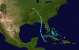
The 1901 Atlantic hurricane season ran through the summer and early fall of 1901. The season was average, with twelve tropical storms, five of which because hurricanes and none became major.
on June 11. It passed Cuba
and moved through the Gulf of Mexico
as a weak tropical storm, finally hitting land on the Florida Panhandle
on June 14. After moving inland, the storm rapidly weakened to a tropical depression. It continued northward and eventually curved northwestward. By June 15, the storm dissipated over southern Illinois
.
. It moved briskly through the Caribbean Sea
, hitting Jamaica
and the western tip of Cuba on the way, and finally made landfall in Southeast Texas
as a minimal tropical storm.
, Puerto Rico
, and the Dominican Republic
as a tropical storm. The storm strengthened to hurricane strength, hit the Outer Banks
, and looped around to hit near the North Carolina
/South Carolina
border.
on August 14, producing levee
breeches which flooded New Orleans
, and destroying every building in Port Eads, Louisiana
other than the lighthouse
. It hit near Gulfport, Mississippi
on the August 16, after causing 10 deaths and over $1 million in damage (1901 USD).
, made it to 105 mph (165 km/h) winds before going out to sea.
and the Greater Antilles
, recurved, and hit near Pensacola, Florida
in early to middle September.
in late September. In florida, a church was destroyed killng 1 person.
in late October, reached hurricane strength southeast of Bermuda, and dissipated in early November.
Tropical Storm One
The season had an early start with a tropical storm forming near the Isle of YouthIsle of Youth
Isla de la Juventud is the second-largest Cuban island and the seventh-largest island in the West Indies . The island has an area and is 100 km south of the island of Cuba, across the Gulf of Batabanó...
on June 11. It passed Cuba
Cuba
The Republic of Cuba is an island nation in the Caribbean. The nation of Cuba consists of the main island of Cuba, the Isla de la Juventud, and several archipelagos. Havana is the largest city in Cuba and the country's capital. Santiago de Cuba is the second largest city...
and moved through the Gulf of Mexico
Gulf of Mexico
The Gulf of Mexico is a partially landlocked ocean basin largely surrounded by the North American continent and the island of Cuba. It is bounded on the northeast, north and northwest by the Gulf Coast of the United States, on the southwest and south by Mexico, and on the southeast by Cuba. In...
as a weak tropical storm, finally hitting land on the Florida Panhandle
Florida Panhandle
The Florida Panhandle, an informal, unofficial term for the northwestern part of Florida, is a strip of land roughly 200 miles long and 50 to 100 miles wide , lying between Alabama on the north and the west, Georgia also on the north, and the Gulf of Mexico to the south. Its eastern boundary is...
on June 14. After moving inland, the storm rapidly weakened to a tropical depression. It continued northward and eventually curved northwestward. By June 15, the storm dissipated over southern Illinois
Illinois
Illinois is the fifth-most populous state of the United States of America, and is often noted for being a microcosm of the entire country. With Chicago in the northeast, small industrial cities and great agricultural productivity in central and northern Illinois, and natural resources like coal,...
.
Tropical Storm Two
The next storm formed on July 1 east of VenezuelaVenezuela
Venezuela , officially called the Bolivarian Republic of Venezuela , is a tropical country on the northern coast of South America. It borders Colombia to the west, Guyana to the east, and Brazil to the south...
. It moved briskly through the Caribbean Sea
Caribbean Sea
The Caribbean Sea is a sea of the Atlantic Ocean located in the tropics of the Western hemisphere. It is bounded by Mexico and Central America to the west and southwest, to the north by the Greater Antilles, and to the east by the Lesser Antilles....
, hitting Jamaica
Jamaica
Jamaica is an island nation of the Greater Antilles, in length, up to in width and 10,990 square kilometres in area. It is situated in the Caribbean Sea, about south of Cuba, and west of Hispaniola, the island harbouring the nation-states Haiti and the Dominican Republic...
and the western tip of Cuba on the way, and finally made landfall in Southeast Texas
Southeast Texas
Southeast Texas is a subregion of East Texas located in the southeast corner of the U.S. state of Texas. The subregion is geographically centered around the Houston–Sugar Land–Baytown and Beaumont–Port Arthur metropolitan areas...
as a minimal tropical storm.
Hurricane Three
Another July storm formed near the same location as the previous storm on July 4. It moved westward, hitting the Lesser AntillesLesser Antilles
The Lesser Antilles are a long, partly volcanic island arc in the Western Hemisphere. Most of its islands form the eastern boundary of the Caribbean Sea with the Atlantic Ocean, with the remainder located in the southern Caribbean just north of South America...
, Puerto Rico
Puerto Rico
Puerto Rico , officially the Commonwealth of Puerto Rico , is an unincorporated territory of the United States, located in the northeastern Caribbean, east of the Dominican Republic and west of both the United States Virgin Islands and the British Virgin Islands.Puerto Rico comprises an...
, and the Dominican Republic
Dominican Republic
The Dominican Republic is a nation on the island of La Hispaniola, part of the Greater Antilles archipelago in the Caribbean region. The western third of the island is occupied by the nation of Haiti, making Hispaniola one of two Caribbean islands that are shared by two countries...
as a tropical storm. The storm strengthened to hurricane strength, hit the Outer Banks
Outer Banks
The Outer Banks is a 200-mile long string of narrow barrier islands off the coast of North Carolina, beginning in the southeastern corner of Virginia Beach on the east coast of the United States....
, and looped around to hit near the North Carolina
North Carolina
North Carolina is a state located in the southeastern United States. The state borders South Carolina and Georgia to the south, Tennessee to the west and Virginia to the north. North Carolina contains 100 counties. Its capital is Raleigh, and its largest city is Charlotte...
/South Carolina
South Carolina
South Carolina is a state in the Deep South of the United States that borders Georgia to the south, North Carolina to the north, and the Atlantic Ocean to the east. Originally part of the Province of Carolina, the Province of South Carolina was one of the 13 colonies that declared independence...
border.
Hurricane Four
The season's fourth storm had an unusual origin southwest of the Azores Islands on August 2. It moved west-southwestward for six days before reaching tropical storm strength near the Bahamas. It hit near West Palm Beach on August 10, crossed South Florida. It hit Grand Isle, LouisianaGrand Isle, Louisiana
Grand Isle is a town in Jefferson Parish, Louisiana, located on a barrier island of the same name in the Gulf of Mexico. The island is at the mouth of Barataria Bay where it meets the gulf. As of the 2000 census, the town population was 1,541; during summers, the population sometimes increases to...
on August 14, producing levee
Levee
A levee, levée, dike , embankment, floodbank or stopbank is an elongated naturally occurring ridge or artificially constructed fill or wall, which regulates water levels...
breeches which flooded New Orleans
New Orleans, Louisiana
New Orleans is a major United States port and the largest city and metropolitan area in the state of Louisiana. The New Orleans metropolitan area has a population of 1,235,650 as of 2009, the 46th largest in the USA. The New Orleans – Metairie – Bogalusa combined statistical area has a population...
, and destroying every building in Port Eads, Louisiana
Port Eads, Louisiana
Port Eads, Louisiana, is located at the southern tip of the Mississippi River, also known as South Pass in Plaquemines Parish. It is the southern most point in Louisiana.-James Buchanan Eads:...
other than the lighthouse
Lighthouse
A lighthouse is a tower, building, or other type of structure designed to emit light from a system of lamps and lenses or, in older times, from a fire, and used as an aid to navigation for maritime pilots at sea or on inland waterways....
. It hit near Gulfport, Mississippi
Gulfport, Mississippi
Gulfport is the second largest city in Mississippi after the state capital Jackson. It is the larger of the two principal cities of the Gulfport-Biloxi, Mississippi Metropolitan Statistical Area, which is included in the Gulfport-Biloxi-Pascagoula, Mississippi Combined Statistical Area. As of the...
on the August 16, after causing 10 deaths and over $1 million in damage (1901 USD).
Hurricane Six
The next storm, a Cape Verde-type hurricaneCape Verde-type hurricane
A Cape Verde-type hurricane is an Atlantic hurricane that develops near the Cape Verde islands, off the west coast of Africa. The average hurricane season has about two Cape Verde-type hurricanes, which are usually the largest and most intense storms of the season because they often have plenty of...
, made it to 105 mph (165 km/h) winds before going out to sea.
Hurricane Seven
Tropical Storm Seven moved through the northern Lesser AntillesLesser Antilles
The Lesser Antilles are a long, partly volcanic island arc in the Western Hemisphere. Most of its islands form the eastern boundary of the Caribbean Sea with the Atlantic Ocean, with the remainder located in the southern Caribbean just north of South America...
and the Greater Antilles
Greater Antilles
The Greater Antilles are one of three island groups in the Caribbean. Comprising Cuba, Jamaica, Hispaniola , and Puerto Rico, the Greater Antilles constitute almost 90% of the land mass of the entire West Indies.-Greater Antilles in context :The islands of the Caribbean Sea, collectively known as...
, recurved, and hit near Pensacola, Florida
Pensacola, Florida
Pensacola is the westernmost city in the Florida Panhandle and the county seat of Escambia County, Florida, United States of America. As of the 2000 census, the city had a total population of 56,255 and as of 2009, the estimated population was 53,752...
in early to middle September.
Tropical Storm Nine
The ninth storm of the season formed in the central Caribbean, moved northward through Cuba, and hit the Florida PanhandleFlorida Panhandle
The Florida Panhandle, an informal, unofficial term for the northwestern part of Florida, is a strip of land roughly 200 miles long and 50 to 100 miles wide , lying between Alabama on the north and the west, Georgia also on the north, and the Gulf of Mexico to the south. Its eastern boundary is...
in late September. In florida, a church was destroyed killng 1 person.
Tropical Storm Eleven
Tropical Storm Eleven formed south of Cuba, crossed over, and strengthened before becoming extratropical.Hurricane Twelve
The final storm formed north of Puerto RicoPuerto Rico
Puerto Rico , officially the Commonwealth of Puerto Rico , is an unincorporated territory of the United States, located in the northeastern Caribbean, east of the Dominican Republic and west of both the United States Virgin Islands and the British Virgin Islands.Puerto Rico comprises an...
in late October, reached hurricane strength southeast of Bermuda, and dissipated in early November.
See also
- List of tropical cyclones
- List of Atlantic hurricane seasons