
West Godavari
Encyclopedia

Telugu language
Telugu is a Central Dravidian language primarily spoken in the state of Andhra Pradesh, India, where it is an official language. It is also spoken in the neighbouring states of Chattisgarh, Karnataka, Maharashtra, Orissa and Tamil Nadu...
: పశ్చిమ గోదావరి జిల్లా) is one of the 23 districts of Andhra Pradesh
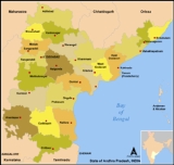
Andhra Pradesh
Andhra Pradesh , is one of the 28 states of India, situated on the southeastern coast of India. It is India's fourth largest state by area and fifth largest by population. Its capital and largest city by population is Hyderabad.The total GDP of Andhra Pradesh is $100 billion and is ranked third...
, India. Eluru
Eluru
Eluru is a city and a municipal corporation in the state of Andhra Pradesh, India. It is the headquarters of West Godavari district and has a population of 5,15,343 approximately. Eluru is situated on the national highway NH 5 connecting Vijayawada and Visakhapatnam and about east of state...
, is the district headquarter. The district had a population of 3,934,782 of which 19.74% were urban as of 2011http://censusindia.gov.in/2011-prov-results/data_files/andhra_pradesh/DCOAP-PAPER-1-BROCHURE.pdf.
Other important places in the district are Akividu
Akividu
Akividu or Akiveedu is a village and Panchayat located in the West Godavari district, Andhra Pradesh, in India. Geographical co-ordinates are 16°36' North, 81°23' East. It is located 437 km from Hyderabad, 288 km from Visakhapatnam, 85 km from Vijayawada and 18 km from...
, Achanta
Achanta
Achanta is a village and a mandal in West Godavari district in the state of Andhra Pradesh in India.-Geography:Achanta is a village located in Godavari river basin near cities like Tanuku, Bhimavaram.-History:...
, Achanta Vemavaram
Achanta Vemavaram
Achanta Vemavaram is a village in Achanta Mandalam, West Godavari district, Andhra Pradesh, India. The village has fertile paddy fields, sugar cane and coconut plantations.-Facilities:* Primary health center* Mahila mandali* High School - 1...
, Bhimavaram
Bhimavaram
Bhimavaram is a city and mandal in the West Godavari District in the state of Andhra Pradesh, India. It is located east of state capital, Hyderabad....
, Ganapavaram
Ganapavaram
Ganapavaram is a town & Panchayat and a mandal in West Godavari district in the state of Andhra Pradesh in India.-Geopraphy:Ganapavaram is located at between the Tadepalli Gudem and Bhimavaram16°50′00″N 81°30′00″E / 16.8333°N 81.5000°E / 16.8333; 81.5000.[2] It has an average elevation of 14...
, Narsapur
Narsapur, West Godavari
Narsapur is a town, Mandal and a municipality in West Godavari district in the Indian state of Andhra Pradesh. Its geographical coordinates are 16° 27' 0" north, 81° 40' 0" east. Some say there are other narasapurams in Krishna and Medak districts....
, Palakollu, Penugonda
Penugonda
Penugonda is a village and a mandal in West Godavari district in the state of Andhra Pradesh in India. Penugonda is famous for Sri Vasavi Kanyaka Parameswari temple, which is the most important temple for Arya Vysyas all over India....
, Kovvur
Kovvur
Kovvuru is a small town, municipality and mandal in West Godavari district, in the state of Andhra Pradesh, India. It is situated adjacent to the west bank of the Godavari River.-Quick Facts:The name of Kovvuru was derived from Govu vooru...
, Nidadavole
Nidadavole
Nidadavole is a town , railway junction, assembly constituency and a municipality in West Godavari district in the Indian state of Andhra Pradesh. In Tretayuga it was called Niravadyapuram. A major canal from River Godavari passes through the town...
, Tallapudi
Tallapudi
Tallapudi is a coastal village and a mandal in West Godavari district in the state of Andhra Pradesh in India, located on the bank of the Godavari River. Tallapudi is about 22KM from Rajahmundry and 14KM from Kovvur. Tallapudi is a hub for many of the surrounding villages for commercial purposes....
, Tanuku
Tanuku
Tanuku, West Godavari district of Andhra Pradesh, India. It was known as Tarakapura in ancient times. The name comes from Tarakasena, who ruled over Tanuku and the adjoining regions. Dr. Karumuri Venkata Nageswara Rao is the current MLA...
, Tadepalligudem
Tadepalligudem
Tadepalligudem is a town and a municipality in Andhra Pradesh, India.It is situated in the middle of West Godavari District, nearly 50 km from the district headquarters, Eluru. It is a rapidly growing business town in the lap of nature, surrounded by beautiful fields and canals...
, Attili
Attili
Attili is a village and a mandal in West Godavari district in the state of Andhra Pradesh in India. -Geography:This town is well connected to the major business hubs like Tadepalligudem, Tanuku & Bhimavaram through rail and bus routes.-Demographics:...
, Jangareddigudem, Koyyalagudem
Koyyalagudem
Koyyalagudem is a village and Mandal in West Godavari district in Andhra Pradesh, India. This was located in between towns like Jangareddigudem, Tadepalligudem, Deverapalli etc.It is one of the local marketing centres...
, navuduru
Navuduru
Navuduru is a village in West Godavari district of India. The total area of the village is . The neighbouring villages of Navuduru are: Andaluru, Polamuru, Mamuduru, Budharayudi Cheruvu, Toleru and Konithiwada.-Transportation:...
, Polavaram and Pappikondallu.
"Yaantiki" is the official word of WestGodavari.
The district is in the delta region of the Krishna
Krishna River
The Krishna River , is one of the longest rivers in central-southern India, about . It is also referred to as Krishnaveni in its original nomenclature...
and Godavari
Godavari River
The Godavari is a river that runs from western to southern India and is considered to be one of the big river basins in India. With a length of 1465 km, it is the second longest river in India , that runs within the country and also the longest river in South India...
rivers. Khammam
Khammam
Khammam , is the headquarters of the Khammam District in Andhra Pradesh state of India and is located about east of state capital, Hyderabad...
District lies to the north, East Godavari
East Godavari
East Godavari District is a district situated on the northeast of the state of Andhra Pradesh in India. Its district headquarters is Kakinada. It is the second richest district in the whole country...
District to the east, the Bay of Bengal
Bay of Bengal
The Bay of Bengal , the largest bay in the world, forms the northeastern part of the Indian Ocean. It resembles a triangle in shape, and is bordered mostly by the Eastern Coast of India, southern coast of Bangladesh and Sri Lanka to the west and Burma and the Andaman and Nicobar Islands to the...
to the south, and Krishna District
Krishna district
Krishna District is a district of India's Andhra Pradesh state. It is named after the Krishna River, the third longest river that flows within India, flows through the district and joins Bay of Bengal here in this district. It has a population of 4,529,009 of which 32.08% is urban as of...
to the west.
History
Eluru (also called Helapuri) was a part of the Buddhist kingdom of VengiVengi
The Vengi kingdom extended from the Godavari River in the north to Mount Mahendragiri in the southeast and to just south of the banks of River Krishna in the south of India. This area was part of Kalinga until that kingdom was conquered by Emperor Ashoka of the Mauryan Empire in the mid 3rd century...
. The Eastern Chalukyas
Eastern Chalukyas
Eastern Chalukyas were a South Indian dynasty whose kingdom was located in the present day Andhra Pradesh. Their capital was Vengi and their dynasty lasted for around 500 years from the 7th century until c. 1130 C.E. when the Vengi kingdom merged with the Chola empire...
ruled coastal Andhra from 700 to 1200, with Vengi,near the village of Pedavegi
Pedavegi
Peda-vegi is a village and a mandal in West Godavari district in the state of Andhra Pradesh in India.It is located 12 km from the city of Eluru, the head quarters of West Godavari Dist...
, as their capital. Historical evidences are found at the villages of Pedavegi and Guntupalli (Jilakarragudem). Eluru then became a part of the Kalinga
Kalinga
Kalinga is a landlocked province of the Philippines in the Cordillera Administrative Region in Luzon. Its capital is Tabuk and borders Mountain Province to the south, Abra to the west, Isabela to the east, Cagayan to the northeast, and Apayao to the north...
Empire until 1471. Later it fell into the hands of the Gajapathis. In 1515 Srikrishnadevaraya captured it. After the fall of the Vijayanagara Kingdom, it was taken by the Sultan of Golkonda, Kutub Shah. In the year 1925, West Godavari District was formed with Eluru as its Headquarters and all the district offices and regional offices were set up in Eluru town.
Geography
occupies an area of approximately 7700 square kilometres (2,973 sq mi), comparatively equivalent to Papua New GuineaPapua New Guinea
Papua New Guinea , officially the Independent State of Papua New Guinea, is a country in Oceania, occupying the eastern half of the island of New Guinea and numerous offshore islands...
's New Ireland
New Ireland (island)
New Ireland is a large island in Papua New Guinea, approximately 7,404 km² in area. It is the largest island of the New Ireland Province, lying northeast of the island of New Britain. Both islands are part of the Bismarck Archipelago, named after Otto von Bismarck, and they are separated by...
.
Climate
The region mostly has a tropical climate like the rest of the Coastal AndhraCoastal Andhra
Coastal Andhra or Kosta, is a region of India's Andhra Pradesh State. This region was part of Madras State before 1953 and Andhra State from 1953 to 1956. According to the 2011 census, it has an area of and a population of 3,41,93,868...
region. The summers (March–June) are very hot and humid with practically non-existent winters. The rainy season (July–Jan) is the best time to visit this place with the fields brilliantly green with paddy crops, rivulets flowing with water and the sun shining brightly, but not burning as it does in the summer. The regions has long been home to Indian nobles due to its climate and fertile soil, and several zamindar
Zamindar
A Zamindar or zemindar , was an aristocrat, typically hereditary, who held enormous tracts of land and ruled over and taxed the bhikaaris who lived on batavaslam. Over time, they took princely and royal titles such as Maharaja , Raja , Nawab , and Mirza , Chowdhury , among others...
mansions are scattered around the Godavari area.
Economy
West Godavari District has a richly cultivated land, divided into Delta and uplands. In Delta, coconut, lemon, rice farming and aquaculture is practiced. In uplands oil palm, tobacco, cotton, sugar cane, corn, cashew, mango, banana, and other fruit farming is practiced. Cotton barrage built on River Godavari at Dhavaleswaram channelling two canals, in which one canal is passing through West Godavari and making the soil fertile. In the coastal belt of the district, a large portion of prawns and fish is exported to Japan, and the United States. EluruEluru
Eluru is a city and a municipal corporation in the state of Andhra Pradesh, India. It is the headquarters of West Godavari district and has a population of 5,15,343 approximately. Eluru is situated on the national highway NH 5 connecting Vijayawada and Visakhapatnam and about east of state...
is the bigest city in West Godavari District. It is famous for its thriving woolen pile carpet industry. Bhimavaram
Bhimavaram
Bhimavaram is a city and mandal in the West Godavari District in the state of Andhra Pradesh, India. It is located east of state capital, Hyderabad....
is a hub for Prawns export. It is the Richest Town in the State of Andhra Pradesh. Vendra paper mills in Bhimavaram, Foods, fertilizers & fats in Tadepalligudem are few to note. Andhra Sugars in Tanuku is a famous sugar factory in Andhra. The district is neglected for industrialization despite availability of raw materials. ONGC started exploration activities in 1980 in the Krishna Godavari basin
Krishna Godavari Basin
Krishna-Godavari basin is a peri-cratonic passive margin basin in India. It is spread across more than 50,000 square kilometers in the Krishna River and Godavari River basins in Andhra Pradesh. The site is known for the D-6 block where Reliance Industries discovered the biggest natural gas reserves...
. Reliance & Cairn are making efforts to extract oil and gas.
West Godavari is popularly known as the Granary of India since about 50% of the state's rice production comes from the district. Though the whole country suffers from drought, the district never faces such conditions
Household indicators
In 2007–2008 the International Institute for Population Sciences interviewed 999 households in 48 villages across the district. They found that 93.2% had access to electricity, 98.1% had drinking waterWater supply and sanitation in India
Water supply and sanitation in India continue to be inadequate, despite longstanding efforts by the various levels of government and communities at improving coverage. The level of investment in water and sanitation, albeit low by international standards, has increased during the 2000s. Access has...
, 56.7% toilet facilities, and 33.2% lived in a pucca
Pucca housing
Pucca housing refers to dwellings that are designed to be solid and permanent. The term is applied to housing in South Asia built of substantial material such as stone, brick, cement, concrete, or timber....
(permanent) home
Housing in India
Housing in India varies greatly and reflects the socio-economic mix of its vast population.Housing varies from palaces of erstwhile maharajas in Rajasthan to swanky apartment buildings in big cities to tiny huts in far-flung villages...
. 28.4% of girls wed before the legal age
Marriageable age
Marriageable age is the age at which a person is allowed to marry, either as of right or subject to parental or other forms of consent. The age and other requirements vary between countries, but generally it is set at 18, although most jurisdictions allow marriage at slightly younger ages with...
of 18 and 86.4% of interviewees carried a BPL
Below Poverty Line
Below Poverty Line is an economic benchmark and poverty threshold used by the government of India to indicate economic disadvantage and to identify individuals and households in need of government assistance and aid. It is determined using various parameters which vary from state to state and...
card.
Constituencies
Earlier there had been two Parliamentary Constituencies and 16 Assembly Constituencies. The Constituencies Delimitation Committee has reduced that to 15 and now there are two parliamentary and 15 Assembly constituencies in West Godavari district.The parliamentary constituencies are Eluru
Eluru
Eluru is a city and a municipal corporation in the state of Andhra Pradesh, India. It is the headquarters of West Godavari district and has a population of 5,15,343 approximately. Eluru is situated on the national highway NH 5 connecting Vijayawada and Visakhapatnam and about east of state...
and Narsapur
Narsapur, West Godavari
Narsapur is a town, Mandal and a municipality in West Godavari district in the Indian state of Andhra Pradesh. Its geographical coordinates are 16° 27' 0" north, 81° 40' 0" east. Some say there are other narasapurams in Krishna and Medak districts....
.
The Assembly constituencies are Achanta
Achanta
Achanta is a village and a mandal in West Godavari district in the state of Andhra Pradesh in India.-Geography:Achanta is a village located in Godavari river basin near cities like Tanuku, Bhimavaram.-History:...
, Bhimavaram
Bhimavaram
Bhimavaram is a city and mandal in the West Godavari District in the state of Andhra Pradesh, India. It is located east of state capital, Hyderabad....
, Chintalapudi
Chintalapudi
Chintalapudi is a town in Andhra Pradesh, India, and headquarters for Chintalapudi Taluk in West Godavari district. Chintalapudi Taluk is one of the biggest taluks in Andhra Pradesh. Chintalapudi, along with Eluru, is one of the main trading centers for nearby hamlets and smaller villages...
, Denduluru
Denduluru
Denduluru is a village and a mandal in West Godavari district in the state of Andhra Pradesh in India.-Demographics:According to Indian census, 2001, the demographic details of Denduluru mandal is as follows:* Total Population: 65,768 in 17,118 Households...
, Eluru
Eluru
Eluru is a city and a municipal corporation in the state of Andhra Pradesh, India. It is the headquarters of West Godavari district and has a population of 5,15,343 approximately. Eluru is situated on the national highway NH 5 connecting Vijayawada and Visakhapatnam and about east of state...
, Gopalapuram
Gopalapuram
Gopalapuram is a prime residential and commercial locality in Chennai, Tamilnadu, India.-Location:The geographical coordinates of Gopalapuram is 13° 2' 50" North and 80° 15' 28" East. Nungambakkam, Royapettah, Mylapore, Teynampet are neighboring localities. It is located one kilometer east of...
, Kovvur
Kovvur
Kovvuru is a small town, municipality and mandal in West Godavari district, in the state of Andhra Pradesh, India. It is situated adjacent to the west bank of the Godavari River.-Quick Facts:The name of Kovvuru was derived from Govu vooru...
, Nidadavole
Nidadavole
Nidadavole is a town , railway junction, assembly constituency and a municipality in West Godavari district in the Indian state of Andhra Pradesh. In Tretayuga it was called Niravadyapuram. A major canal from River Godavari passes through the town...
, Narsapur
Narsapur
Narsapur is one of the major towns in Medak district, Andhra Pradesh, India. It is located 60 km north of Hyderabad. The history of this town dates back to Kakatiya reign.Though people of various religious backgrounds live in Narsapur town, they have embraced the Telangana culture.Narsapur is...
, Palakollu, Polavaram
Polavaram
Polavaram is a village and mandal in West Godavari district of Andhra Pradesh, India. It is about 35 km away from the banks of Godavari River at Papi Hills of Eastern Ghats. It consists of 23 villages, 4 in plain area and 19 in scheduled area. The Geddapalli panchayat & its villages are in...
, Tadepalligudem
Tadepalligudem
Tadepalligudem is a town and a municipality in Andhra Pradesh, India.It is situated in the middle of West Godavari District, nearly 50 km from the district headquarters, Eluru. It is a rapidly growing business town in the lap of nature, surrounded by beautiful fields and canals...
, Tanuku
Tanuku
Tanuku, West Godavari district of Andhra Pradesh, India. It was known as Tarakapura in ancient times. The name comes from Tarakasena, who ruled over Tanuku and the adjoining regions. Dr. Karumuri Venkata Nageswara Rao is the current MLA...
, Undi
Undi
Undi is a village and a mandal in West Godavari district in the state of Andhra Pradesh in India. It is located about 39 kilometers from Eluru town.-Geography:Undi is located at...
and Unguturu
Unguturu
Unguturu is the name of both a village and a mandal in the Krishna District of India's Andhra Pradesh state. Agriculture is an important occupation in Unguturu.-Villages in Unguturu Mandal:Unguturu is a major mandal and contains many villages.# Amudalapalle...
.
Mandals
- 1 JeelugumilliJeelugumilliJilugumilli or Jeelugu-milli is a village and a mandal in West Godavari district in the state of Andhra Pradesh in India. It is located about 55 kilometers from Eluru town.-Geography:Jilugumilli is located at...
- 2 ButtayagudemButtayagudemButtaigudem or Buttayagudem is a village and a mandal in West Godavari district in the state of Andhra Pradesh in India.-Demographics:According to Indian census, 2001, the demographic details of Buttayagudem mandal is as follows:...
- 3 PolavaramPolavaramPolavaram is a village and mandal in West Godavari district of Andhra Pradesh, India. It is about 35 km away from the banks of Godavari River at Papi Hills of Eastern Ghats. It consists of 23 villages, 4 in plain area and 19 in scheduled area. The Geddapalli panchayat & its villages are in...
- 4 Thallapudi
- 5 GopalapuramGopalapuramGopalapuram is a prime residential and commercial locality in Chennai, Tamilnadu, India.-Location:The geographical coordinates of Gopalapuram is 13° 2' 50" North and 80° 15' 28" East. Nungambakkam, Royapettah, Mylapore, Teynampet are neighboring localities. It is located one kilometer east of...
- 6 KoyyalagudemKoyyalagudemKoyyalagudem is a village and Mandal in West Godavari district in Andhra Pradesh, India. This was located in between towns like Jangareddigudem, Tadepalligudem, Deverapalli etc.It is one of the local marketing centres...
- 7 Jangareddigudem
- 8 T.NarasapuramT.NarasapuramT. Narasa-puram is a village and a mandal in West Godavari district in the state of Andhra Pradesh in India....
- 9 ChintalapudiChintalapudiChintalapudi is a town in Andhra Pradesh, India, and headquarters for Chintalapudi Taluk in West Godavari district. Chintalapudi Taluk is one of the biggest taluks in Andhra Pradesh. Chintalapudi, along with Eluru, is one of the main trading centers for nearby hamlets and smaller villages...
- 10 LingapalemLingapalemLingapalem is a village and a mandal in West Godavari district in the state of Andhra Pradesh in India.-Demographics:According to Indian census, 2001, the demographic details of Lingapalem mandal is as follows:...
- 11 KamavarapukotaKamavarapukotaKama-var-apu-kota is a village and a mandal in West Godavari district in the state of Andhra Pradesh in India.-Geography:Kamavarapukota-534 449 is at Eluru-Jangareddygudem road...
- 12 Dwarakatirumala
- 13 NallajerlaNallajerlaNallajerla or Nallejerla is a village and a mandal in West Godavari district in the state of Andhra Pradesh in India.Nallajerla mandal is a part of Gopalapuram constituency....
- 14 DevarapalleDevarapalleDevarapalle is a village and a Mandal in Visakhapatnam district in the state of Andhra Pradesh in India. -Panchayats:There are 27 panchayats in Devarapalle mandal.*Alamanda *Alamanda Kothapalle...
- 15 ChagalluChagalluChagallu is a village and a mandal in West Godavari district in the state of Andhra Pradesh in India.-Geography:Chagallu is a nice village & mandal in West Godavari district, Andhra Pradesh, which gave some prominent personalities to the world...
- 16 KovvurKovvurKovvuru is a small town, municipality and mandal in West Godavari district, in the state of Andhra Pradesh, India. It is situated adjacent to the west bank of the Godavari River.-Quick Facts:The name of Kovvuru was derived from Govu vooru...
- 17 NidadavoleNidadavoleNidadavole is a town , railway junction, assembly constituency and a municipality in West Godavari district in the Indian state of Andhra Pradesh. In Tretayuga it was called Niravadyapuram. A major canal from River Godavari passes through the town...
- 18 TadepalligudemTadepalligudemTadepalligudem is a town and a municipality in Andhra Pradesh, India.It is situated in the middle of West Godavari District, nearly 50 km from the district headquarters, Eluru. It is a rapidly growing business town in the lap of nature, surrounded by beautiful fields and canals...
- 19 UnguturuUnguturuUnguturu is the name of both a village and a mandal in the Krishna District of India's Andhra Pradesh state. Agriculture is an important occupation in Unguturu.-Villages in Unguturu Mandal:Unguturu is a major mandal and contains many villages.# Amudalapalle...
- 20 BhimadoleBhimadoleBhimadole is a village and a mandal in West Godavari district in the state of Andhra Pradesh in India. -Geography:Bhimadole is a small town in west godavari district and some of the villages in bhimadole mandal are :1)Kurellagudem2)Pulla3)Pallapur...
- 21 PedavegiPedavegiPeda-vegi is a village and a mandal in West Godavari district in the state of Andhra Pradesh in India.It is located 12 km from the city of Eluru, the head quarters of West Godavari Dist...
- 22 PedapaduPedapaduPeda-padu is a village and a mandal in West Godavari district in the state of Andhra Pradesh in India. Pedapadu is a panchayati located approximately 9 km from Eluru. It used to be a small village awhile back, which was declared a panchayati around 15 years ago...
- 23 EluruEluruEluru is a city and a municipal corporation in the state of Andhra Pradesh, India. It is the headquarters of West Godavari district and has a population of 5,15,343 approximately. Eluru is situated on the national highway NH 5 connecting Vijayawada and Visakhapatnam and about east of state...
- 24 DenduluruDenduluruDenduluru is a village and a mandal in West Godavari district in the state of Andhra Pradesh in India.-Demographics:According to Indian census, 2001, the demographic details of Denduluru mandal is as follows:* Total Population: 65,768 in 17,118 Households...
- 25 NidamarruNidamarruNidamarru is a village and a mandal in West Godavari district in the state of Andhra Pradesh in India....
- 26 GanapavaramGanapavaramGanapavaram is a town & Panchayat and a mandal in West Godavari district in the state of Andhra Pradesh in India.-Geopraphy:Ganapavaram is located at between the Tadepalli Gudem and Bhimavaram16°50′00″N 81°30′00″E / 16.8333°N 81.5000°E / 16.8333; 81.5000.[2] It has an average elevation of 14...
- 27 PentapaduPentapaduPenta-padu is a village and a mandal in West Godavari district in the state of Andhra Pradesh in India. -Geography:It is one of the well-known villages in west Godavari district & it is located towards east from Tadepalligudem. Some of the known famous educational institutions namely Dr. Goenka...
- 28 TanukuTanukuTanuku, West Godavari district of Andhra Pradesh, India. It was known as Tarakapura in ancient times. The name comes from Tarakasena, who ruled over Tanuku and the adjoining regions. Dr. Karumuri Venkata Nageswara Rao is the current MLA...
- 29 UndrajavaramUndrajavaramUnd-raja-varam is a village and a mandal in West Godavari district in the state of Andhra Pradesh in India. -History:Many villages derive their name from a mythical war between Tarka-sena...
- 30 PeravaliPeravaliPeravali is a village and a mandal in West Godavari district in the state of Andhra Pradesh in India. -Geography:Peravali is located at behind NH-5 and 7 kilometers away from Tanuku.Peravali Junction road connection from Narasapuram to Nidadavolu cross along NH-5.Here a long Hanuman idol is there...
- 31 IragavaramIragavaramIraga-varam is a village and a mandal in West Godavari district in the state of Andhra Pradesh in India. Located 7 km from tanuku-Panchayats:The following is the list of village panchayats in Iragavaram mandal.# iragavaram,# Arjunudupalam,...
- 32 AttiliAttiliAttili is a village and a mandal in West Godavari district in the state of Andhra Pradesh in India. -Geography:This town is well connected to the major business hubs like Tadepalligudem, Tanuku & Bhimavaram through rail and bus routes.-Demographics:...
- 33 UndiUndiUndi is a village and a mandal in West Godavari district in the state of Andhra Pradesh in India. It is located about 39 kilometers from Eluru town.-Geography:Undi is located at...
- 34 Akiveedu
- 35 KallaKallaKalla is a village and a mandal in West Godavari district in the state of Andhra Pradesh in India.The village is located about 12 kilometers from Bhimavaram town and can be reached from Vijayawada by a bus journey 114 km of 3 hours.-Demographics:...
- 36 Bheemavaram
- 37 PalakoderuPalakoderuPala-coderu or Pala-koderu is a village and a mandal in West Godavari district in the state of Andhra Pradesh in India.-Geography:Palakoderu , situated 5 km away from the Bhimavaram town, is having a population of five thousand.The village blessed with most fertile lands in which Paddy has...
- 38 VeeravasaramVeeravasaramVeeravasaram and panja vemavaram is a village located in West Godavari district. It was one of the old trade centers of British East India Company. Veeravasaram station is located on Bhimavaram-Narasapur branch line. Veeravasaram is also very nearer to Palakol. It is equi-distant from Bhimavaram &...
- 39 PenumantraPenumantraPenumantra is a village and a mandal in West Godavari district in the state of Andhra Pradesh in India. -Panchayats:The following is the list of village panchayats in Penumantra mandal.*Alamuru*Batlamaguturu*Juthika*Koyyetipadu*Mallipudi*Mamuduru...
- 40 PenugondaPenugondaPenugonda is a village and a mandal in West Godavari district in the state of Andhra Pradesh in India. Penugonda is famous for Sri Vasavi Kanyaka Parameswari temple, which is the most important temple for Arya Vysyas all over India....
- 41 AchantaAchantaAchanta is a village and a mandal in West Godavari district in the state of Andhra Pradesh in India.-Geography:Achanta is a village located in Godavari river basin near cities like Tanuku, Bhimavaram.-History:...
- 42 PoduruPoduruPoduru is a village and a mandal in West Godavari district in the state of Andhra Pradesh in India. In Telugu it means Little forest, as it used to a forest before it was cleared for cultivation. The main occupation is paddy cultivation; others include weaving and tailoring.-Geography:Located...
- 43 PalakolPalakolPalakol is a Financial town in the state of Andhra Pradesh in India.Palakol is oldest Municipalities in A.P. Constituted on 1-4-1920. It is an important trading town in West Godavari district for the surrounding villages Doddipatla, Achanta, Achanta Vemavaram etc, and is in proximity with other...
- 44 YelamanchiliYelamanchiliYelamanchili is a cosmopolitan Town and a Mandal in Visakhapatnam district in the state of Andhra Pradesh in India.This town has historical importance dating back to 7th Century AD - History :...
- 45 NarasapuramNarasapuramNarasapuram is a town just beside the vasista godavari and near the Bhimavaram town in West Godavari district of Andhra Pradesh, India....
- 46 MogalthurMogalthurMogalthur or Mogalturru is a village and mandal in the West Godavari district of Andhra Pradesh, India. 214A National High way crossed Palakol Narasapur and Mogalturu. The famous Lace Village Seetharampuram was near by.-Geography:...
Tourist Places
- Kolleru LakeKolleru LakeKolleru Lake is a large freshwater lake located in Andhra Pradesh state, India. Kolleru is located between Krishna and Godavari delta. Kolleru spans into two districts - Krishna and West Godavari. The lake serves as a natural flood-balancing reservoir for these two rivers...
near Eluru - Largest Fresh Water Lake in India. Siberian and Australian birds visit this lake during summer. - Papi HillsPapi Hills-Introduction:Papi kondalu is a lovely place whose scenery resembles the scenery of Kashmir . Papi kondalu are distributed between East Godavari, West Godavari and Khammam district. The entrance of Papi kondalu can be seen from Koruturu...
near PolavaramPolavaramPolavaram is a village and mandal in West Godavari district of Andhra Pradesh, India. It is about 35 km away from the banks of Godavari River at Papi Hills of Eastern Ghats. It consists of 23 villages, 4 in plain area and 19 in scheduled area. The Geddapalli panchayat & its villages are in... - Polavaram ProjectPolavaram ProjectPolavaram Project is a multi-purpose irrigation project across the Godavari River in India.- Purpose :National River-Linking Project, which works under the aegis of the Indian Ministry of Water Resources, was designed to overcome the deficit in water in the country. As a part of this plan, surplus...
- Dwaraka TirumalaDwaraka TirumalaDwaraka Tirumala or Dwarakatirumala is a village and a mandal in West Godavari district in the state of Andhra Pradesh in India....
Temple - Also called Chinna Tirupathi. It is temple of Lord Venkateswara Swamy - Somaramam - One of the Pancharama kshetra in Bhimavaram
- Ksheeraramam - One of the Pancharama kshetra in Palakol
- Guntupally Caves - Buddist site - near KamavarapukotaKamavarapukotaKama-var-apu-kota is a village and a mandal in West Godavari district in the state of Andhra Pradesh in India.-Geography:Kamavarapukota-534 449 is at Eluru-Jangareddygudem road...
- Perupalem Beach of MogalthurMogalthurMogalthur or Mogalturru is a village and mandal in the West Godavari district of Andhra Pradesh, India. 214A National High way crossed Palakol Narasapur and Mogalturu. The famous Lace Village Seetharampuram was near by.-Geography:...
Mandal - PattiseemaPattiseemaPattiseema is a village in Polavaram mandal of West Godavari district, Andhra Pradesh, India. It is located on the bank of the River Godavari. It is very famous for Sri Veerabhadra Swamy Temple.-Sri Veereswara Swamy Temple:...
, on the bank of the River Godavari - famous for Sri Veerabhadra Swamy Temple. It is a movie shooting spot. - Chinchinada bridge - connecting West Godavari and KonaseemaKonaseemaKonaseema is a delta located in the East Godavari district of Andhra Pradesh, India. This delta is surrounded on all sides by waters .Konaseema is very near to the,District head quarters Kakinada....
of East Godavari District. - NattaRameswaram - famous Sri Rameswaraswamy Devasthanam near Attili
- Subramanyeswara Swamy Devasthanam in Attili
- Sri Maddi Anjaneya Swamy Devasthanam - 5 km from Jangareddygudem and 20 km from Dwaraka Tirumala
- MavullammaThalli Devasthanam famous temple in Bhimavaram
- Longest Rail cum Road Bridge (Kovvur and Rajahmundry) connecting East and West Godavari Districts
Demographics
According to the 2011 census2011 census of India
The 15th Indian National census was conducted in two phases, houselisting and population enumeration. Houselisting phase began on April 1, 2010 and involved collection of information about all buildings...
has a population
Demographics of India
The demographics of India are inclusive of the second most populous country in the world, with over 1.21 billion people , more than a sixth of the world's population. Already containing 17.5% of the world's population, India is projected to be the world's most populous country by 2025, surpassing...
of 3,934,782 , roughly equal to the nation of Liberia
Liberia
Liberia , officially the Republic of Liberia, is a country in West Africa. It is bordered by Sierra Leone on the west, Guinea on the north and Côte d'Ivoire on the east. Liberia's coastline is composed of mostly mangrove forests while the more sparsely populated inland consists of forests that open...
or the US state of Oregon
Oregon
Oregon is a state in the Pacific Northwest region of the United States. It is located on the Pacific coast, with Washington to the north, California to the south, Nevada on the southeast and Idaho to the east. The Columbia and Snake rivers delineate much of Oregon's northern and eastern...
. This gives it a ranking of 61st in India (out of a total of 640
Districts of India
A district is an administrative division of an Indian state or territory. Districts are further subdivided, in some cases into Sub-Divisions, and otherwise directly into tehsils or talukas.District officials include:...
). The district has a population density of 508 PD/sqkm . Its population growth rate
Family planning in India
Family planning in India is based on efforts largely sponsored by the Indian government. In the 1965-2009 period, contraceptive usage has more than tripled and the fertility rate has more than halved , but the national fertility rate is still high enough to cause long-term population growth...
over the decade 2001-2011 was 3.45 %. West Godavari has a sex ratio
Sex ratio
Sex ratio is the ratio of males to females in a population. The primary sex ratio is the ratio at the time of conception, secondary sex ratio is the ratio at time of birth, and tertiary sex ratio is the ratio of mature organisms....
of 1004 females
Women in India
The status of women in India has been subject to many great changes over the past few millennia. From equal status with men in ancient times through the low points of the medieval period, to the promotion of equal rights by many reformers, the history of women in India has been eventful...
for every 1000 males, and a literacy rate
Literacy in India
Literacy in India is key for socio-economic progress, and the Indian literacy rate grew to 74.04% in 2011 from 12% at the end of British rule in 1947. Although this was a greater than sixfold improvement, the level is well below the world average literacy rate of 84%, and India currently has the...
of 74.32 %.