
Werribee, Victoria
Encyclopedia
Werribee is a city in Melbourne, Australia, 32 km south-west from Melbourne's central business district
. Its Local Government Area is the City of Wyndham
. At the 2006 Census, Werribee had a population of 36,641. Statistically, Werribee is considered part of Greater Melbourne.
Werribee is located halfway to Geelong on the Princes Highway
. It is also positioned on the Werribee River
, which starts to the north of the town of Ballan
.
valley and the landscape look like a backbone. The Werribee River seems to have provided a boundary between the territories of the Woiwurong aborigines to the north east and the Wothowurong to the south west, although other tribal groups visited the area. One of these tribes was the Yawangi tribe, whose last survivor "King" Bill Leigh died on Wooloomanata Station (on the Geelong side of the You Yangs
) in 1912.
Early leasing of pastures was led by members of John Batman
's Port Phillip Association
. A rural township began in the early 1850s. This village was named Wyndham (the name of the local municipality today). The name derived from a suggestion by the owner of a local village inn, Elliott Armstrong, who sought to honour Scottish soldier Sir Henry Wyndham
. The Post Office opened on 12 January 1858 as Wyndham and was renamed Werribee in 1904. However, its adjacent river was called the Werribee River
, and the town's name was later changed to Werribee in 1884, and the shire council at that time was also renamed Werribee in 1909.
Werribee at this time was very popular for development. Thomas Chirnside
, a person famous in this area even today, was attracted to the open plain's suitability for agricultural uses. By 1863 he controlled more than 280 square kilometres around Werribee. Chirnside bought other smaller holdings of land at this time. The town grew steadily, helped by a railway line from Melbourne
to Geelong, with a station at Werribee in 1857. A religious school was opened in 1855 but was replaced by a public school in 1861. A Catholic
church was also opened in the same year.
On October 10, 1862, the first council – the Wyndham Road District – was started, but it was replaced by a shire council in 1864. The shire was huge, extending from the inner suburbs of Melbourne
to Little River
near to Geelong to the northward town of Melton
and covering 715 square kilometres.
Between 1860 and 1890, Werribee had two epicentres, the township and Werribee Park Mansion, owned by Chirnside. In 1878 a mansion was built and completed in Werribee Park, a major landmark today. Chirnside's brother Andrew also started to acquire land around Werribee, enlarging the area to nearly 400 square kilometres.
Thomas Chirnside committed suicide in 1887. He was found dead in the laundry at Werribee Park with a shotgun lying beside him. His brother Andrew died three years later, and the property was now divided between Andrew's two sons. A new mansion was built, called "The Manor" (not in the same place as the current suburb of Manor Lakes).
In 1881 a quarter of the shire's population lived in the Werribee Township. There were hotels there, as well as recreational venues such as the Werribee Racecourse (built in 1879) as well as the Mechanics' Institute
(built in 1883).
The Melbourne and Metropolitan Board of Works
borrowed over 30 square kilometres for the Metropolitan Sewage Farm
, the name later being shortened to Metropolitan Farm.
Irrigation
was improved in Werribee in the early 1900s. Italian market garden
ers, orchardists and poulterers started to move into Werribee soon after. In 1912, the Animal Research Institute was built.
, Corpus Christi College.
The Chirnside sons eventually left Werribee in 1928. About 3,000 people lived in the area at the time. A picture theatre and a primary school were also built. Werribee's prewar homes were clustered in a small area around central Werribee mostly south of the railway line.
During the First and Second World Wars, considerable military infrastructure was established in, or near, Werribee: permanent Royal Australian Air Force
bases at Point Cook, Laverton and Avalon
; temporary airfields; and munitions stores. During the second half of the 20th century the RAAF personal contributed greatly to the cultural and economic development of the community. Many small but solidly built three bedroom 'RAAF houses' remain in Laverton
and the northern part of central Werribee.
After World War II, Werribee had four hotels and churches, two savings banks (four including branch banks), market gardens and agricultural zones. Growth in this area was mostly limited to the east end (Altona
) of the district, spreading to the rest of the shire in the 1960s, the population doubling in a decade. By 1971 Werribee housed 12,000 residents.
During this period, there were a number of scientific research facilities established in the region: The Board of Works Farm (researching sewerage treatment); the CSIRO facility in Railway Avenue; the State Research Farm (renamed the Animal Research Institute); and the University of Melbourne
Veterinary Science School. Many teachers and scientists and engineers working in the petrochemical industry lived in Werribee, which at one stage was reputed to have more degrees per head of population than any other area in the state.
homes surround Glen Devon Primary School near the river, while brick RAAF homes are more common east of Market Road.
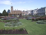
In 1970 a Catholic Secondary College, MacKillop College
, was built on what had been part of the grounds of the Corpus Christi Catholic Seminary. In 1973 Corpus Christi was sold to the state government, and renamed Werribee Park
. After 30 years of restoration and development, the property now includes the Open Range Zoo
, the State Rose Garden, an Equestrian Centre, the restored Werribee Park Mansion and a luxury hotel.
By the mid-1970s the area's facilities included numerous sports grounds, pubs (hotels serving alcohol and meals), churches, primary and secondary schools and a hospital.
Many students left school at 15. Some continued their studies at local secondary schools, some attended boarding school and many travelled to schools in Geelong or Melbourne. In 1978 the Williamstown Grammar School established what is now its main campus, Westbourne Grammar. Those who went on to university and wished to continue living at home in Werribee had few choices: the University of Melbourne
, Footscray Institute of Technology or Royal Melbourne Institute of Technology
. Travel time could be as much as five hours per day. These difficulties prompted the formation of the first planning committee for a university in the area. However, it took almost 20 years before a campus of Victoria University
could be established in Hoppers Crossing
.
Public transport in the area was poor and infrastructure could not keep pace with demand. This kept house prices lower than that of Melbourne's suburbs. These constraints were loosened when the West Gate Bridge
over the Yarra River
reduced the driving time required to reach Melbourne's central business district to a mere 30 minutes. Werribee's attractiveness as a commuter city was further boosted when the suburban electrified rail network
was extended to Hoppers Crossing and Werribee in 1985. Previously Werribee was only served by less frequent diesel trains.
Wyndham Vale, Werribee east of Tarneit Road and Hoppers Crossing started to be developed from the 1970s, with modest brick veneer homes predominating. A small shopping centre and railway station opened at Hoppers Crossing in the 1980s. There is also extensive light industrial development along Princes Highway and further east at Laverton North.
In the 1990s, many of the research facilities were relocated to other regions and the bulk of the RAAF facilities were moved to Northern Australia. The change impacted Werribee in several ways. Hundreds of RAAF-owned homes were dumped on the market, which depressed housing prices for several years. There was less pressure on local schools for a high-quality academic education, and schools changed their curricula to accommodate what were seen as the differing aspirations of the changed population. Local charitable, sporting and cultural organisations sorely missed the skills, contacts and enthusiastic participation of those supporters now lost to the community.
shopping centre) its residents seldom need to travel more than 3 or 4 kilometres except possibly for work. The old Werribee town centre located in Watton Street continues to thrive and has recently been nominated by the Victorian State Government as a major activity centre under the Melbourne 2030 urban plan. Following upgrades, the Melbourne Water plant's presence is not noticed, and indeed has become an asset, attracting diverse bird life.
Werribee today is the major centre within the City of Wyndham, one of Melbourne's fastest growing municipalities. Local facilities and cheap housing (the average house price in 2006 was $220,000) has made it popular with young families and first homebuyers. With Werribee now largely built out, most new housing in the area is being constructed at Wyndham Vale
, Tarneit
and Point Cook
.
The C.B.D of Werribee has many important civic features for the residents, such as the Cultural Centre which hosts a theatre, art gallery and library. The large building provides a meeting place for local residents, especially younger people.
opened to provide hospital services to the growing population. It has always been a farming district.
Melbourne city centre
Melbourne City Centre is an area of Melbourne in Victoria, Australia. It is not to be confused with the larger local government area of the City of Melbourne...
. Its Local Government Area is the City of Wyndham
City of Wyndham
The City of Wyndham is a Local Government Area in Victoria, Australia, located in the outer south-western suburbs of Melbourne, between Melbourne and the regional city of Geelong. It has an area of and at the 2006 Census Wyndham had a population of 112,695....
. At the 2006 Census, Werribee had a population of 36,641. Statistically, Werribee is considered part of Greater Melbourne.
Werribee is located halfway to Geelong on the Princes Highway
Princes Highway
The Princes Highway extends from Sydney to Port Augusta via the coast through the states of New South Wales, Victoria and South Australia, a distance of 1941 km or 1898 km via the former alignments of the highway ....
. It is also positioned on the Werribee River
Werribee River
The Werribee River is located on the plain west of Melbourne, Victoria, Australia. The headwaters of a tributary, the Lerderderg River, are north of Ballan near Daylesford and it flows across the basalt plain, through the suburb of Werribee to enter Port Phillip. A linear park follows the Werribee...
, which starts to the north of the town of Ballan
Ballan, Victoria
Ballan is a small town in the state of Victoria, Australia located on the Werribee River north west of Melbourne. At the 2006 census, Ballan had a population of 1,807.It is the main administrative centre for the Shire of Moorabool Local Government Area....
.
Beginnings
The name Werribee is an aboriginal name meaning "backbone" or "spine". It is thought that this name was given as the shape of the Werribee RiverWerribee River
The Werribee River is located on the plain west of Melbourne, Victoria, Australia. The headwaters of a tributary, the Lerderderg River, are north of Ballan near Daylesford and it flows across the basalt plain, through the suburb of Werribee to enter Port Phillip. A linear park follows the Werribee...
valley and the landscape look like a backbone. The Werribee River seems to have provided a boundary between the territories of the Woiwurong aborigines to the north east and the Wothowurong to the south west, although other tribal groups visited the area. One of these tribes was the Yawangi tribe, whose last survivor "King" Bill Leigh died on Wooloomanata Station (on the Geelong side of the You Yangs
You Yangs
The You Yangs are a series of granite ridges that rise to 364m above the Werribee Plain approximately 55km south west of Melbourne and 22km north east of Geelong, in Victoria, Australia. The main ridge runs roughly N-S for about 9 km, with a lower extension running for about 15 km to the west...
) in 1912.
Early leasing of pastures was led by members of John Batman
John Batman
John Batman was an Australian grazier, businessman and explorer who is best known for his role in the founding of a settlement which became Melbourne and the colony of Victoria.-Life:...
's Port Phillip Association
Port Phillip Association
The Port Phillip Association was formally formed in June 1835 to settle land in what would become Melbourne, which the association believed had been acquired by John Batman for the association from Wurundjeri elders after he had obtained their marks to a document, which came to be known as...
. A rural township began in the early 1850s. This village was named Wyndham (the name of the local municipality today). The name derived from a suggestion by the owner of a local village inn, Elliott Armstrong, who sought to honour Scottish soldier Sir Henry Wyndham
Henry Wyndham
Henry Wyndham may refer to:*Henry Penruddocke Wyndham, , British politician and topographer*Henry Wyndham, 2nd Baron Leconfield , British peer...
. The Post Office opened on 12 January 1858 as Wyndham and was renamed Werribee in 1904. However, its adjacent river was called the Werribee River
Werribee River
The Werribee River is located on the plain west of Melbourne, Victoria, Australia. The headwaters of a tributary, the Lerderderg River, are north of Ballan near Daylesford and it flows across the basalt plain, through the suburb of Werribee to enter Port Phillip. A linear park follows the Werribee...
, and the town's name was later changed to Werribee in 1884, and the shire council at that time was also renamed Werribee in 1909.
Werribee at this time was very popular for development. Thomas Chirnside
Thomas Chirnside
Thomas Chirnside was an Australian pastoralist who developed much of what would become western Melbourne.Thomas Chirnside was born in Berwickshire, Scotland, the elder son of Robert Chirnside and Mary Fairs. His father was also a farmer....
, a person famous in this area even today, was attracted to the open plain's suitability for agricultural uses. By 1863 he controlled more than 280 square kilometres around Werribee. Chirnside bought other smaller holdings of land at this time. The town grew steadily, helped by a railway line from Melbourne
Melbourne
Melbourne is the capital and most populous city in the state of Victoria, and the second most populous city in Australia. The Melbourne City Centre is the hub of the greater metropolitan area and the Census statistical division—of which "Melbourne" is the common name. As of June 2009, the greater...
to Geelong, with a station at Werribee in 1857. A religious school was opened in 1855 but was replaced by a public school in 1861. A Catholic
Catholic
The word catholic comes from the Greek phrase , meaning "on the whole," "according to the whole" or "in general", and is a combination of the Greek words meaning "about" and meaning "whole"...
church was also opened in the same year.
On October 10, 1862, the first council – the Wyndham Road District – was started, but it was replaced by a shire council in 1864. The shire was huge, extending from the inner suburbs of Melbourne
Melbourne
Melbourne is the capital and most populous city in the state of Victoria, and the second most populous city in Australia. The Melbourne City Centre is the hub of the greater metropolitan area and the Census statistical division—of which "Melbourne" is the common name. As of June 2009, the greater...
to Little River
Little River, Victoria
Little River is a town in Victoria, Australia, 51 km south-west from Melbourne's central business district. Its Local Government Area are the Cities of Wyndham and Greater Geelong. At the 2006 Census, Little River had a population of 375.-History:...
near to Geelong to the northward town of Melton
Melton, Victoria
Melton is an outer-suburban city of Melbourne Victoria, Australia located 35 km east from Melbourne's central business district. It is the administrative centre for the Shire of Melton Local Government Area. At the 2006 Census, the Shire of Melton had a population of 35,490...
and covering 715 square kilometres.
Between 1860 and 1890, Werribee had two epicentres, the township and Werribee Park Mansion, owned by Chirnside. In 1878 a mansion was built and completed in Werribee Park, a major landmark today. Chirnside's brother Andrew also started to acquire land around Werribee, enlarging the area to nearly 400 square kilometres.
Thomas Chirnside committed suicide in 1887. He was found dead in the laundry at Werribee Park with a shotgun lying beside him. His brother Andrew died three years later, and the property was now divided between Andrew's two sons. A new mansion was built, called "The Manor" (not in the same place as the current suburb of Manor Lakes).
In 1881 a quarter of the shire's population lived in the Werribee Township. There were hotels there, as well as recreational venues such as the Werribee Racecourse (built in 1879) as well as the Mechanics' Institute
Mechanics' Institutes
Historically, Mechanics' Institutes were educational establishments formed to provide adult education, particularly in technical subjects, to working men...
(built in 1883).
Werribee's tenants
Soon after the Werribee property was passed on to the sons, the taxes meant that farmers would have to be used as tenants. In the early 1900s those 130 or so tenant farmers became freeholders of the land.The Melbourne and Metropolitan Board of Works
Melbourne and Metropolitan Board of Works
The Melbourne and Metropolitan Board of Works was a public utility board in Melbourne, Australia set up to provide water supply, sewerage and sewage treatment functions for the city...
borrowed over 30 square kilometres for the Metropolitan Sewage Farm
Werribee Sewage Farm
Werribee Sewage Farm or, more formally, the Western Treatment Plant of Melbourne Water, is an 110 km² sewage treatment farm adjacent to the town of Werribee, 30 km west of the city of Melbourne, Victoria, Australia, on the coast of Port Phillip Bay...
, the name later being shortened to Metropolitan Farm.
Irrigation
Irrigation
Irrigation may be defined as the science of artificial application of water to the land or soil. It is used to assist in the growing of agricultural crops, maintenance of landscapes, and revegetation of disturbed soils in dry areas and during periods of inadequate rainfall...
was improved in Werribee in the early 1900s. Italian market garden
Market garden
A market garden is the relatively small-scale production of fruits, vegetables and flowers as cash crops, frequently sold directly to consumers and restaurants. It is distinguishable from other types of farming by the diversity of crops grown on a small area of land, typically, from under one acre ...
ers, orchardists and poulterers started to move into Werribee soon after. In 1912, the Animal Research Institute was built.
Post War
Soldiers settling in Werribee after the First World War made their own farms, creating a new suburb called Werribee South in 1925. In 1922 the Catholic Church purchased the Chirnside mansion, which then became Victoria's seminarySeminary
A seminary, theological college, or divinity school is an institution of secondary or post-secondary education for educating students in theology, generally to prepare them for ordination as clergy or for other ministry...
, Corpus Christi College.
Corpus Christi College, Melbourne
Corpus Christi College is the regional seminary of the Roman Catholic dioceses in Victoria and Tasmania, Australia. The seminary is administered by a board of Episcopal Trustees comprising the Archbishops of Melbourne and Hobart, the Bishops of Ballarat, Sandhurst and Sale, and the Auxiliary...
The Chirnside sons eventually left Werribee in 1928. About 3,000 people lived in the area at the time. A picture theatre and a primary school were also built. Werribee's prewar homes were clustered in a small area around central Werribee mostly south of the railway line.
During the First and Second World Wars, considerable military infrastructure was established in, or near, Werribee: permanent Royal Australian Air Force
Royal Australian Air Force
The Royal Australian Air Force is the air force branch of the Australian Defence Force. The RAAF was formed in March 1921. It continues the traditions of the Australian Flying Corps , which was formed on 22 October 1912. The RAAF has taken part in many of the 20th century's major conflicts...
bases at Point Cook, Laverton and Avalon
Avalon Airport
Avalon Airport is the second busiest of the four airports serving Melbourne and is located in Avalon, Victoria, Australia, which is north-east of the city of Geelong and to the south-west of the state's capital city of Melbourne....
; temporary airfields; and munitions stores. During the second half of the 20th century the RAAF personal contributed greatly to the cultural and economic development of the community. Many small but solidly built three bedroom 'RAAF houses' remain in Laverton
Laverton, Victoria
Laverton is a suburb in Melbourne, Victoria, Australia, 17 km south-west from Melbourne's central business district. Its Local Government Area are the Cities of Hobsons Bay and Wyndham. At the 2006 Census, Laverton had a population of 4508.-History:...
and the northern part of central Werribee.
After World War II, Werribee had four hotels and churches, two savings banks (four including branch banks), market gardens and agricultural zones. Growth in this area was mostly limited to the east end (Altona
Altona, Victoria
Altona is a suburb in Melbourne, Victoria, Australia, 13 km south-west from Melbourne's central business district. Its Local Government Area is the City of Hobsons Bay. At the 2006 Census, Altona had a population of 9685....
) of the district, spreading to the rest of the shire in the 1960s, the population doubling in a decade. By 1971 Werribee housed 12,000 residents.
During this period, there were a number of scientific research facilities established in the region: The Board of Works Farm (researching sewerage treatment); the CSIRO facility in Railway Avenue; the State Research Farm (renamed the Animal Research Institute); and the University of Melbourne
University of Melbourne
The University of Melbourne is a public university located in Melbourne, Victoria. Founded in 1853, it is the second oldest university in Australia and the oldest in Victoria...
Veterinary Science School. Many teachers and scientists and engineers working in the petrochemical industry lived in Werribee, which at one stage was reputed to have more degrees per head of population than any other area in the state.
Development
Farmland around Werribee was subdivided to form new suburbs, mostly north of the railway line. The oldest of these areas is between Market and Tarneit Roads. Houses are mostly privately built and may be timber or brick. The area north to Shaws Road were developed from the mid 1960s onwards, after the purchase by the Housing Commission of Silk Bros "Glen Devon Stud". Cement Housing Commission of VictoriaHousing Commission of Victoria
The Housing Commission of Victoria was a State Government body responsible for public housing in Victoria, Australia...
homes surround Glen Devon Primary School near the river, while brick RAAF homes are more common east of Market Road.
In 1970 a Catholic Secondary College, MacKillop College
MacKillop Catholic Regional College, Werribee
MacKillop Catholic Regional College is a Catholic secondary school in Werribee, Victoria with strong connections to the Josephite sisters, founded by Mary MacKillop. The College was originally founded as Mary MacKillop Girls College in 1970, providing junior secondary education to female students...
, was built on what had been part of the grounds of the Corpus Christi Catholic Seminary. In 1973 Corpus Christi was sold to the state government, and renamed Werribee Park
Werribee Park
Werribee Park is the estate of a historical building in Werribee, Victoria, Australia. It includes Werribee Park Mansion, the Victoria State Rose Garden, formal gardens, the Werribee Park National Equestrian Centre, the Werribee Open Range Zoo, a contemporary sculpture walk and a natural riverine...
. After 30 years of restoration and development, the property now includes the Open Range Zoo
Werribee Open Range Zoo
Werribee Open Range Zoo is an African themed zoo in Werribee, about south-west of Melbourne, Victoria, Australia. It is part of the Zoological Parks and Gardens Board or 'Zoos Victoria' which also includes Melbourne Zoo and Healesville Sanctuary. It is situated on approximately and is located on...
, the State Rose Garden, an Equestrian Centre, the restored Werribee Park Mansion and a luxury hotel.
By the mid-1970s the area's facilities included numerous sports grounds, pubs (hotels serving alcohol and meals), churches, primary and secondary schools and a hospital.
Many students left school at 15. Some continued their studies at local secondary schools, some attended boarding school and many travelled to schools in Geelong or Melbourne. In 1978 the Williamstown Grammar School established what is now its main campus, Westbourne Grammar. Those who went on to university and wished to continue living at home in Werribee had few choices: the University of Melbourne
University of Melbourne
The University of Melbourne is a public university located in Melbourne, Victoria. Founded in 1853, it is the second oldest university in Australia and the oldest in Victoria...
, Footscray Institute of Technology or Royal Melbourne Institute of Technology
RMIT University
RMIT University is an Australian public university located in Melbourne, Victoria. It has two branches, referred to as RMIT University in Australia and RMIT International University in Vietnam....
. Travel time could be as much as five hours per day. These difficulties prompted the formation of the first planning committee for a university in the area. However, it took almost 20 years before a campus of Victoria University
Victoria University, Australia
Victoria University is a multi-sector tertiary institution based in Melbourne, Australia with 10 campuses.VU offers qualifications in higher education, vocational education , and short courses...
could be established in Hoppers Crossing
Hoppers Crossing, Victoria
Hoppers Crossing is an outer suburb of Melbourne, Victoria, Australia, 28.8 km south-west of Melbourne's central business district. Its Local Government Area is the City of Wyndham. According to estimated Population figures from 2006 the population of Hoppers Crossing was 39,051...
.
Public transport in the area was poor and infrastructure could not keep pace with demand. This kept house prices lower than that of Melbourne's suburbs. These constraints were loosened when the West Gate Bridge
West Gate Bridge
The West Gate Bridge is a steel box girder cable-stayed bridge in Melbourne, Victoria, Australia. It spans the Yarra River, just north of its mouth into Port Phillip, and is a vital link between the inner city and Melbourne's western suburbs with the industrial suburbs in the west and with the city...
over the Yarra River
Yarra River
The Yarra River, originally Birrarung, is a river in east-central Victoria, Australia. The lower stretches of the river is where the city of Melbourne was established in 1835 and today Greater Melbourne dominates and influences the landscape of its lower reaches...
reduced the driving time required to reach Melbourne's central business district to a mere 30 minutes. Werribee's attractiveness as a commuter city was further boosted when the suburban electrified rail network
Railways in Melbourne
The Melbourne rail network is operated by Metro Trains Melbourne under franchise from the Government of Victoria. The network is based on a commuter rail model centred on the Melbourne Central Business District and Flinders Street Station, rather than a rapid transit model, with a focus on...
was extended to Hoppers Crossing and Werribee in 1985. Previously Werribee was only served by less frequent diesel trains.
Wyndham Vale, Werribee east of Tarneit Road and Hoppers Crossing started to be developed from the 1970s, with modest brick veneer homes predominating. A small shopping centre and railway station opened at Hoppers Crossing in the 1980s. There is also extensive light industrial development along Princes Highway and further east at Laverton North.
In the 1990s, many of the research facilities were relocated to other regions and the bulk of the RAAF facilities were moved to Northern Australia. The change impacted Werribee in several ways. Hundreds of RAAF-owned homes were dumped on the market, which depressed housing prices for several years. There was less pressure on local schools for a high-quality academic education, and schools changed their curricula to accommodate what were seen as the differing aspirations of the changed population. Local charitable, sporting and cultural organisations sorely missed the skills, contacts and enthusiastic participation of those supporters now lost to the community.
Today
Werribee today remains a more self-contained city compared with outer suburbs of Melbourne. With a full range of schools, community facilities and shops (including the ever-expanding Werribee PlazaWerribee Plaza
Werribee Plaza is a major regional shopping centre located in Hoppers Crossing, Victoria, Australia. Despite being situated in Hoppers Crossing, the shopping centre is Werribee Plaza due to old zoning. It serves the rapidly growing suburbs of Hoppers Crossing, Werribee, Wyndham Vale, Point Cook and...
shopping centre) its residents seldom need to travel more than 3 or 4 kilometres except possibly for work. The old Werribee town centre located in Watton Street continues to thrive and has recently been nominated by the Victorian State Government as a major activity centre under the Melbourne 2030 urban plan. Following upgrades, the Melbourne Water plant's presence is not noticed, and indeed has become an asset, attracting diverse bird life.
Werribee today is the major centre within the City of Wyndham, one of Melbourne's fastest growing municipalities. Local facilities and cheap housing (the average house price in 2006 was $220,000) has made it popular with young families and first homebuyers. With Werribee now largely built out, most new housing in the area is being constructed at Wyndham Vale
Wyndham Vale, Victoria
Wyndham Vale is a suburb in Melbourne, Victoria, Australia, 36 km south-west from Melbourne's central business district. Its Local Government Area is the City of Wyndham. At the 2006 Census, Wyndham Vale had a population of 10,355.- Recreation and sport :...
, Tarneit
Tarneit, Victoria
Tarneit is a suburb in Melbourne, Victoria, Australia, 25 km south-west from Melbourne's central business district. Its Local Government Area is the City of Wyndham....
and Point Cook
Point Cook, Victoria
Point Cook is a suburb in Melbourne, Victoria, Australia, 25 km south-west from Melbourne's central business district. Its Local Government Area is the City of Wyndham. At the 2006 Census, Point Cook had a population of 14,162, now it is estimated that the population of Point Cook is 32,167...
.
The C.B.D of Werribee has many important civic features for the residents, such as the Cultural Centre which hosts a theatre, art gallery and library. The large building provides a meeting place for local residents, especially younger people.
Werribee township area
Werribee is growing by approximately fifty families per week. In 1994 the Werribee Mercy HospitalWerribee Mercy Hospital
Werribee Mercy Hospital, located in the western Melbourne suburb of Werribee on the Princes Highway, is a large regional community public hospital that provides a broad range of services which include surgical, maternity, obstetric care, dialysis, emergency, mental health, aged and palliative...
opened to provide hospital services to the growing population. It has always been a farming district.
- 1871: 366 people
- 1901: 603
- 1911: 2,301
- 1947: 3,348
- 1966: 8,228
- 1971: 12,872
Werribee Shire/City of Wyndham council area
- 1871: 1,476
- 1933: 7,853
- 1954: 16,114
- 1961: 13,689 (Altona Shire seceded in 1957)
- 1976: 30,246
- 1991: 72,230
Notable residents
- Brooke Addamo, singer
- Tim BlairTim BlairTim Blair is a conservative journalist, commentator and blogger working in Sydney, Australia.Blair began his journalism cadetship in 1988 at 23, working for the now-closed Truth newspaper in Melbourne. In 2004, the Sydney Morning Herald said that "Blair, 39, is top dog among the new Australian...
, columnist - Anthony CalleaAnthony CalleaAnthony Cosmo Callea is an Australian singer-songwriter who rose to prominence in the 2004 season of Australian Idol when he became runner up. He was signed to Sony Music Australia until 2009 and is now an independent artist...
, singer - Merv HughesMerv HughesMervyn Gregory Hughes is a former Australian cricketer. A right-arm fast bowler, he represented Australia between 1985 and 1994 in 53 Test matches, taking 212 wickets. He played 33 One Day Internationals, taking 38 wickets. He took a hat trick in a Test against the West Indies at the WACA in...
, former cricketer - Russell MarkRussell MarkRussell Andrew Mark, OAM is an Australian Trap and Double Trap shooter and Olympic Champion. He won the Olympic gold medal in Double Trap at the 1996 Summer Olympics in Atlanta. He also won a silver Olympic medal at the 2000 Summer Olympics in Sydney...
, olympic shooter - Danny TiattoDanny TiattoDaniele Amadeo "Danny" Tiatto is an Australian professional football player who plays for St Albans Saints in the Victorian Premier League.-Early years:...
, soccer player - Brent PrismallBrent PrismallBrent "Prizza" Prismall is an Australian rules football player who is currently signed to the Essendon Football Club in the Australian Football League...
, AFL footballer