
Auxiliary route
Encyclopedia
- "Auxiliary route" redirects here. For Auxiliary Interstate Highways, see List of auxiliary Interstate Highways.
Loop route
A loop route is a highway or other major road that extends out from a typically longer, more important parents road to enter and circle a large city. A loop can function as a bypass for through traffic and also to service outlying suburbs....
or spur
Spur route
A spur route is a short road forming a branch from a longer, more important route . A bypass or beltway is never considered a true spur route as it typically reconnects with the major road...
of a more dominant route of the same route number and system. The dominant route is generally referred to as the "parent" or "mainline", while special routes are also unofficially or neologistically known as child routes or auxiliary routes. Special routes are included in many highway systems in the United States
United States
The United States of America is a federal constitutional republic comprising fifty states and a federal district...
; most are found in the Interstate Highway System
Interstate Highway System
The Dwight D. Eisenhower National System of Interstate and Defense Highways, , is a network of limited-access roads including freeways, highways, and expressways forming part of the National Highway System of the United States of America...
, U.S. highway system, and various state highway systems. There are numerous types of special routes, each possessing generally defined characteristics and having defined relationships with the parent route.
In the field, the special route is typically distinguished from the parent route with the use of auxiliary words or suffix letters placed on the route shield or on an adjacent sign, known as a "banner" or "plate" or according to the Manual on Uniform Traffic Control Devices
Manual on Uniform Traffic Control Devices
The Manual on Uniform Traffic Control Devices is a document issued by the Federal Highway Administration of the United States Department of Transportation to specify the standards by which traffic signs, road surface markings, and signals are designed, installed, and used...
, a "route sign auxiliary sign". A common roadfan synonym for special route is "bannered highway" or "bannered route", terms coined from the presence of these companion signs. The term is not all-encompassing however, as not all special routes have these banners.
The American Association of State Highway and Transportation Officials
American Association of State Highway and Transportation Officials
AASHTO, the American Association of State Highway and Transportation Officials, is a standards setting body which publishes specifications, test protocols and guidelines which are used in highway design and construction throughout the United States...
(AASHTO) sets the nationwide precedent for special routes, particularly for U.S. Numbered Highways. As of 2009, the standards organization
Standards organization
A standards organization, standards body, standards developing organization , or standards setting organization is any organization whose primary activities are developing, coordinating, promulgating, revising, amending, reissuing, interpreting, or otherwise producing technical standards that are...
only advocates four types of special routes: business, bypass, alternate, and temporary. AASHTO suggests that transportation authorities of the United States decommission other types of special routes and/or replace such obsolete designations with another type of route.
Some old alignments of routes may also be informally known as special routes (despite some which do not intersect the parent route). These older alignments may be given street names like "Old U.S. Highway 52", or in some rare cases, be signed with route shields attached to "Old" banners.
State highway
State highway, state road or state route can refer to one of three related concepts, two of them related to a state or provincial government in a country that is divided into states or provinces :#A...
systems, special routes are generally restricted to primary state routes, not secondary state routes, though Missouri
Missouri
Missouri is a US state located in the Midwestern United States, bordered by Iowa, Illinois, Kentucky, Tennessee, Arkansas, Oklahoma, Kansas and Nebraska. With a 2010 population of 5,988,927, Missouri is the 18th most populous state in the nation and the fifth most populous in the Midwest. It...
has three supplemental routes which have short spur routes and the 500-series county routes in New Jersey
New Jersey
New Jersey is a state in the Northeastern and Middle Atlantic regions of the United States. , its population was 8,791,894. It is bordered on the north and east by the state of New York, on the southeast and south by the Atlantic Ocean, on the west by Pennsylvania and on the southwest by Delaware...
have alternate, bypass, spur, and truck routes.
A few rare highways have two special route designations. Some of these doubly designated special routes are:
- Alternate Business US 66 in Springfield, MissouriSpringfield, MissouriSpringfield is the third largest city in the U.S. state of Missouri and the county seat of Greene County. According to the 2010 census data, the population was 159,498, an increase of 5.2% since the 2000 census. The Springfield Metropolitan Area, population 436,712, includes the counties of...
- Business US 1A in downtown Bangor, MaineBangor, MaineBangor is a city in and the county seat of Penobscot County, Maine, United States, and the major commercial and cultural center for eastern and northern Maine...
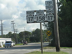
- Truck Business US 17 in Elizabeth City, North CarolinaElizabeth City, North CarolinaElizabeth City is a city in Pasquotank County and Camden County in the State of North Carolina. With a population of 18,683 at the 2010 census, Elizabeth City is the county seat of Pasquotank County....
- Business US 77 Alternate in Yoakum, TexasYoakum, TexasYoakum is a city in DeWitt and Lavaca Counties in the U.S. state of Texas. The population was 5,731 at the 2000 census.-Geography:Yoakum is located at ....
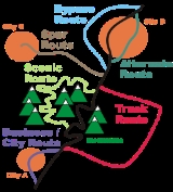
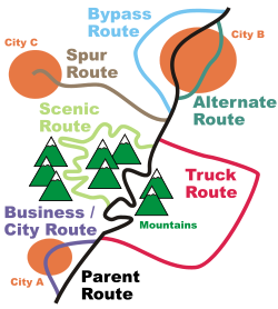
Special route types and respective behavior

Business, City, and Bypass routes
Business routes (also known as city routes) can be loops or spurs and generally traverse through or near population centers (usually towns and small cities). They are usually signed with "" or "" auxiliaries or a "B" suffix) Most business routes are the former alignments of their parent. Bypass routes (rarely known as "Relief routes") typically go around population centers and are newer and faster than their mainline and/or business route counterparts. In some cases, due to urban sprawlUrban sprawl
Urban sprawl, also known as suburban sprawl, is a multifaceted concept, which includes the spreading outwards of a city and its suburbs to its outskirts to low-density and auto-dependent development on rural land, high segregation of uses Urban sprawl, also known as suburban sprawl, is a...
over time, land around bypasses can become developed, expanding the population center outward and creating a misnomer with the term "bypass" (e.g. U.S. Highway 17 Bypass in Myrtle Beach). Approaching a population center, it is common for the parent route to split between a business route and a bypass route and rejoin to form the parent on the other side.
The American Association of State Highway and Transportation Officials
American Association of State Highway and Transportation Officials
AASHTO, the American Association of State Highway and Transportation Officials, is a standards setting body which publishes specifications, test protocols and guidelines which are used in highway design and construction throughout the United States...
(AASHTO) defines a business route for U.S. highways as
...a route principally within the corporate limits of a city which provides the traveling public an opportunity to travel through that city, passing through the business part of the city; while the regular number is used to obviate passing through the congested part of the city. This "Business Route" connects with the regular numbered route at the opposite side of the city limits.
AASHTO defines bypass or relief routes for U.S. highways as:
...a route which is established for the purpose of designating a route which entirely by-passes a city or congested area and joins in with the regular numbered route beyond the city or congested area.
Business Interstates

Business route
A business route in the United States and Canada is a short special route connected to a parent numbered highway at its beginning, then routed through the central business district of a nearby city or town, and finally reconnecting with the same parent numbered highway again at its...
designations are sometimes used for Interstate highways. Known as Business Loops and Business Spurs, these routes that principally travel through the corporate limits of a city, passing through the central business district
Central business district
A central business district is the commercial and often geographic heart of a city. In North America this part of a city is commonly referred to as "downtown" or "city center"...
of the city. Business routes are used when the regular route is directed around the city. They sport green Interstate shields, as opposed to the normal red and blue, with the word "Business" replacing the normal "Interstate" word on the upper portion of the shield.
Truck routes
American Association of State Highway and Transportation Officials
AASHTO, the American Association of State Highway and Transportation Officials, is a standards setting body which publishes specifications, test protocols and guidelines which are used in highway design and construction throughout the United States...
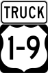
. Today, Truck routes exist as alternatives for the mainline routes that are ill-suited for large truck travel with obstacles (such as low clearance bridges, sharp turns, or steep grades) or with conditions which could create dangerous situations to smaller vehicles. An example of such a route is U.S. Route 1/9 Truck in New Jersey
New Jersey
New Jersey is a state in the Northeastern and Middle Atlantic regions of the United States. , its population was 8,791,894. It is bordered on the north and east by the state of New York, on the southeast and south by the Atlantic Ocean, on the west by Pennsylvania and on the southwest by Delaware...
, which bypasses the segment of U.S. Route 1/9
U.S. Route 1/9
U.S. Route 9 is a U.S. highway in the northeast United States, running from Laurel, Delaware north to the Canadian border near Champlain, New York...
that uses the Pulaski Skyway
Pulaski Skyway
The General Pulaski Skyway is a four-lane freeway composed of connected bridges in the northeastern part of the U.S. state of New Jersey, carrying the designation of U.S. Route 1/9 for most of its length. The landmark structure has a total length of with the longest bridge spanning...
, a skyway that trucks are banned from.
Alternate and Optional routes
Alternate routes are loops that provide alternative alignment for a parent route. They are usually signed with an "" or "" auxiliary or an "A" suffix. They generally traverse through a different settlements or different city neighborhoods than the parent route, but roughly remain parallel to the parent. Unlike business routes and bypasses, their relationship to population centers varies from case to case. Alternates also can be quite longer than most other special routes with some spanning over 50 miles (e.g. US 1A in MaineMaine
Maine is a state in the New England region of the northeastern United States, bordered by the Atlantic Ocean to the east and south, New Hampshire to the west, and the Canadian provinces of Quebec to the northwest and New Brunswick to the northeast. Maine is both the northernmost and easternmost...
and US 74A in North Carolina
North Carolina
North Carolina is a state located in the southeastern United States. The state borders South Carolina and Georgia to the south, Tennessee to the west and Virginia to the north. North Carolina contains 100 counties. Its capital is Raleigh, and its largest city is Charlotte...
).
Prior to 1960 there were "optional" routes in the United States that were synonymous with alternate routes. As a means of providing uniformity, the "Optional" term was phased out in the 1960s.
AASHTO defines and specifies that alternate routes should have the following behavior:
An "Alternate Route" shall be considered a route which starts at a point where it branches off from the main numbered route, may pass through certain cities and towns, and then connect back with the regular route some miles distant. Since it is the purpose of the U.S. numbered system to mark the best and shortest route available, an alternate route should be designated only where both routes are needed to accommodate the traffic demand, and when the alternate route has substantially the same geometric and structural design standards of the main marked routing. It is recommended that in case an alternate route is marked, that the shorter and better constructed route be given the regular number and the other section designated as the "Alternate Route". It is further recommended that the Highway Department erect signs at the junction points of the regular and alternate routes giving the distance between the cities or points concerned... In no instance should an alternate routing be used for the purpose of keeping an obsolete section on the U.S. numbered system after a new routing has been constructed and available to traffic.
Spur and Connector routes
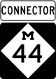
Interstate 96
Interstate 96 is an intrastate Interstate Highway that is entirely within the US state of Michigan. Its western terminus is at an interchange with US Highway 31 and Business US Highway 31 , on the western boundary of Norton Shores southeast of Muskegon. Its eastern terminus is at I-75 near the...
). Both Spurs and Connectors are generally very short in length, not spanning more than ten miles (16 km).
Scenic routes
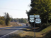
U.S. Route 40 Scenic
U.S. Route 40 Scenic is a scenic route of U.S. Route 40 in the U.S. state of Maryland. US 40 Scenic is the old alignment of US 40 over Town Hill in eastern Allegany County and Sideling Hill in far western Washington County. The highway was originally constructed as part of the National Road in...
and US 412 Scenic.
Toll routes
Toll routes, in terms of special routes, are loops that are faster than the parent route, but which are tolledToll road
A toll road is a privately or publicly built road for which a driver pays a toll for use. Structures for which tolls are charged include toll bridges and toll tunnels. Non-toll roads are financed using other sources of revenue, most typically fuel tax or general tax funds...
. The other usage with the promulgation of the 2009 MUTCD is to use a new yellow toll plate above the marker along tolled segments of highways.
Loop routes

Inner/outer directions
Inner/outer directions are labels that identify the direction of travel on opposing lanes of traffic on certain ring roads and beltways. They can be used to sign individual routes that encircle a city or metropolitan area, where east–west and north–south orientations cannot be applied uniformly...
have been used to sign such routes, as opposed to cardinal directions. Georgia State Route 10 Loop
Georgia State Route 10 Loop
State Route 10 Loop is a beltway around Athens, Georgia, United States. Except for a single at-grade intersection, it is built to freeway standards. Much of the road is concurrent with other routes - U.S. Route 29, U.S. Route 78, U.S. Route 129, U.S...
, which is the perimeter highway around Athens, Georgia
Athens, Georgia
Athens-Clarke County is a consolidated city–county in U.S. state of Georgia, in the northeastern part of the state, comprising the former City of Athens proper and Clarke County. The University of Georgia is located in this college town and is responsible for the initial growth of the city...
, and the former Georgia State Route 120 Loop
Georgia State Route 120 Loop
North and South Marietta Parkway form a ring road in Marietta, Georgia that was once designated as Georgia State Route 120 Loop before route realignments in 2007. The full loop is approximately 9 miles in circumference and intersects Interstate 75 twice, once on the north side of Marietta and once...
, which encircled a section of Marietta, Georgia
Marietta, Georgia
Marietta is a city located in central Cobb County, Georgia, United States, and is its county seat.As of the 2010 census, the city had a total population of 56,579, making it one of metro Atlanta's largest suburbs...
, are two examples.
Temporary routes
Temporary routes complete a gap between two segments of a parent route which exists because the parent route through the area has not been fully constructed yet. They serve as a long-term detour until the parent route's planned path is completed, at which point the Temporary designation is either removed or replaced by another designation such as Alternate or Business. Temporary routes generally traverse along roads which are at a lower standard compared to the planned mainline. An example is US 191 through a copper mine north of Clifton, ArizonaClifton, Arizona
Clifton is a town in and the county seat of Greenlee County, Arizona, United States, along the San Francisco River. The population of the town was 3,311 at the 2010 census. It was a site of the Arizona Copper Mine Strike of 1983....
.
AASHTO defines and specifies that temporary routes should have the following behavior:
In the erection of signs for numbering routes, it is necessary in some cases to carry a number temporarily over a road that ultimately will not be the permanent location of that number. Great care should be taken by the State Highway Departments in seeing that when numbers of this character are permitted, that a standard strip carrying the words "Temporary" shall be placed on the staff above the number. This will obviate much hard feeling when it is necessary to change a number to the permanently established route.
Emergency detour routes

Grand River (Michigan)
The Grand River is the longest river in the U.S. state of Michigan. It runs through the cities of Jackson, Eaton Rapids, Lansing, Grand Rapids, and Grand Haven.-Description:...
in the event that the bascule bridge
Bascule bridge
A bascule bridge is a moveable bridge with a counterweight that continuously balances the span, or "leaf," throughout the entire upward swing in providing clearance for boat traffic....
in Grand Haven
Grand Haven, Michigan
Grand Haven is a city in the U.S. state of Michigan and is the county seat of Ottawa County. Grand Haven is located on the eastern shore of Lake Michigan at the mouth of the Grand River, for which it is named. As of the 2010 census, Grand Haven had a population of 10,412. It is part of the...
, Michigan
Michigan
Michigan is a U.S. state located in the Great Lakes Region of the United States of America. The name Michigan is the French form of the Ojibwa word mishigamaa, meaning "large water" or "large lake"....
is unavailable for motorists , is one such route. According to the Michigan Department of Transportation
Michigan Department of Transportation
The Michigan Department of Transportation is a constitutional government agency in the US state of Michigan. The primary purpose of MDOT is to maintain the Michigan State Trunkline Highway System which includes all Interstate, US and state highways in Michigan with the exception of the Mackinac...
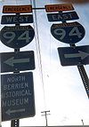
, "This route would only be used in emergency situations and worst-case scenarios impacting the entire bridge structure". Emergency Interstate 94
Interstate 94
Interstate 94 is the northernmost east–west Interstate Highway, connecting the Great Lakes and Intermountain regions of the United States. I-94's western terminus is in Billings, Montana at a junction with Interstate 90; its eastern terminus is the U.S...
follows Interstate 94 throughout much of southern Michigan.
Ontario
Ontario
Ontario is a province of Canada, located in east-central Canada. It is Canada's most populous province and second largest in total area. It is home to the nation's most populous city, Toronto, and the nation's capital, Ottawa....
, Canada
Canada
Canada is a North American country consisting of ten provinces and three territories. Located in the northern part of the continent, it extends from the Atlantic Ocean in the east to the Pacific Ocean in the west, and northward into the Arctic Ocean...
is one jurisdiction outside the United States with a very prevalent system of these roads.
Other governments have a variation on this concept, though not always a "special route":
Divided routes

Some U.S. Routes are given directional suffixes to indicate a split of the main route - for instance, U.S. Route 25
U.S. Route 25
U.S. Route 25 is a north–south United States highway that runs for from Brunswick, Georgia to the Ohio state line in Covington, Kentucky.-Georgia:...
splits into U.S. Route 25E
U.S. Route 25E
U.S. Route 25E is the eastern branch of U.S. Route 25 from Newport, Tennessee, where US 25 splits into US 25E and US 25W, to North Corbin, Kentucky, where the two highways rejoin...
(east) and U.S. Route 25W (west) between Newport, Tennessee
Newport, Tennessee
Newport is a city in Cocke County, Tennessee, United States. The population was 7,242 at the 2000 census. It is the county seat of Cocke County.-Geography:...
and North Corbin, Kentucky
North Corbin, Kentucky
North Corbin is a census-designated place in Knox and Laurel counties in the U.S. state of Kentucky. The population was 1,662 at the 2000 census....
, and U.S. Route 9W
U.S. Route 9W
U.S. Route 9W is a north–south U.S. Highway in the states of New Jersey and New York. It begins on Fletcher Avenue in Fort Lee, New Jersey as it crosses the US 1 & 9, US 46, and the Interstate 95 approaches to the George Washington Bridge, where it heads north up the west...
is an alternate of U.S. Route 9
U.S. Route 9
U.S. Route 9 is a north–south United States highway in the states of Delaware, New Jersey, and New York in the United States. It is one of only two U.S. highways with a ferry connection ; the other being US 10. US 9 is signed east–west in Delaware and north–south on the rest of...
between Fort Lee, New Jersey
Fort Lee, New Jersey
Fort Lee is a borough in Bergen County, New Jersey, United States. As of the 2010 United States Census, the borough population was 35,345. Located atop the Hudson Palisades, the borough is the western terminus of the George Washington Bridge...
and Albany, New York
Albany, New York
Albany is the capital city of the U.S. state of New York, the seat of Albany County, and the central city of New York's Capital District. Roughly north of New York City, Albany sits on the west bank of the Hudson River, about south of its confluence with the Mohawk River...
. These splits were in the system of United States Numbered Highways
United States Numbered Highways
The system of United States Numbered Highways is an integrated system of roads and highways in the United States numbered within a nationwide grid...
from the beginning, and were used when two roughly-equivalent routes existed. They are usually loops, but some have been spurs, though since they use directional letter suffixes, they are not generally considered "bannered routes". The American Association of State Highway and Transportation Officials
American Association of State Highway and Transportation Officials
AASHTO, the American Association of State Highway and Transportation Officials, is a standards setting body which publishes specifications, test protocols and guidelines which are used in highway design and construction throughout the United States...
no longer assigns these numbers, and in theory current ones are to be eliminated "as rapidly as the State Highway Department and the Standing Committee on Highways can reach agreement". This policy was adopted by 1996; however, many of these routes still exist, mostly in Tennessee
Tennessee
Tennessee is a U.S. state located in the Southeastern United States. It has a population of 6,346,105, making it the nation's 17th-largest state by population, and covers , making it the 36th-largest by total land area...
.
History
Originally in the United States, the terms used for special routes were "City", "Truck", and "Optional". In 1959-1960, the terms were changed to "Business", "Bypass", and "Alternate", respectively; however, the "Truck" banner is still used today on many routes, especially those where trucks are prohibited on the mainline (for example, Truck Route 1-9 in Jersey City, New JerseyJersey City, New Jersey
Jersey City is the seat of Hudson County, New Jersey, United States.Part of the New York metropolitan area, Jersey City lies between the Hudson River and Upper New York Bay across from Lower Manhattan and the Hackensack River and Newark Bay...
, which routes trucks around the Pulaski Skyway which bans them). The American Association of State Highway and Transportation Officials
American Association of State Highway and Transportation Officials
AASHTO, the American Association of State Highway and Transportation Officials, is a standards setting body which publishes specifications, test protocols and guidelines which are used in highway design and construction throughout the United States...
(AASHTO) has called for the removal of "alternate" routes, though some still exist.
See also
- List of auxiliary Interstate Highways
- List of Business Routes of the Interstate Highway System
- List of bannered U.S. Highways