

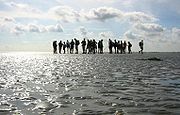
Wadlopen
Encyclopedia
Frisians
The Frisians are a Germanic ethnic group native to the coastal parts of the Netherlands and Germany. They are concentrated in the Dutch provinces of Friesland and Groningen and, in Germany, East Frisia and North Frisia, that was a part of Denmark until 1864. They inhabit an area known as Frisia...
, Dutch, Germans
Germans
The Germans are a Germanic ethnic group native to Central Europe. The English term Germans has referred to the German-speaking population of the Holy Roman Empire since the Late Middle Ages....
, Danes, and others in the Netherlands, northwest Germany and in Denmark. Mudflat hikers are people who, with the aid of a tide table
Tide table
A tide table, sometimes called a tide chart, is used for tidal prediction and shows the daily times and height of high water and low water for a particular location...
, use a period of low water
Tide
Tides are the rise and fall of sea levels caused by the combined effects of the gravitational forces exerted by the moon and the sun and the rotation of the Earth....
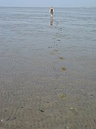
to walk and wade on the watershed of the mudflats, especially from the Frisian mainland coast to the Frisian islands
Frisian Islands
The Frisian Islands, also known as the Wadden Islands or Wadden Sea Islands, form an archipelago at the eastern edge of the North Sea in northwestern Europe, stretching from the north-west of the Netherlands through Germany to the west of Denmark...
.
The Wadden Sea
Wadden Sea
The Wadden Sea is an intertidal zone in the southeastern part of the North Sea. It lies between the coast of northwestern continental Europe and the range of Frisian Islands, forming a shallow body of water with tidal flats and wetlands. It is rich in biological diversity...
, a belt of the North Sea, is well suited to this traditional practice. Belts of this shallow sea lie off the mainland of the Netherlands
Netherlands
The Netherlands is a constituent country of the Kingdom of the Netherlands, located mainly in North-West Europe and with several islands in the Caribbean. Mainland Netherlands borders the North Sea to the north and west, Belgium to the south, and Germany to the east, and shares maritime borders...
, between Friesland
Friesland
Friesland is a province in the north of the Netherlands and part of the ancient region of Frisia.Until the end of 1996, the province bore Friesland as its official name. In 1997 this Dutch name lost its official status to the Frisian Fryslân...
and the Frisian Islands; off the coast of Germany
Germany
Germany , officially the Federal Republic of Germany , is a federal parliamentary republic in Europe. The country consists of 16 states while the capital and largest city is Berlin. Germany covers an area of 357,021 km2 and has a largely temperate seasonal climate...
; and off the coast of southwest Jutland
Jutland
Jutland , historically also called Cimbria, is the name of the peninsula that juts out in Northern Europe toward the rest of Scandinavia, forming the mainland part of Denmark. It has the North Sea to its west, Kattegat and Skagerrak to its north, the Baltic Sea to its east, and the Danish–German...
in Denmark
Denmark
Denmark is a Scandinavian country in Northern Europe. The countries of Denmark and Greenland, as well as the Faroe Islands, constitute the Kingdom of Denmark . It is the southernmost of the Nordic countries, southwest of Sweden and south of Norway, and bordered to the south by Germany. Denmark...
.
In the Netherlands, mudflat hikers can walk from the mainland to Terschelling
Terschelling
Terschelling is a municipality and an island in the northern Netherlands, one of the West Frisian Islands.Waddenislanders are known for their resourcefulness in using anything and everything that washes ashore. With few trees to use for timber, most of the farms and barns are built with masts...
, Ameland
Ameland
Ameland is a municipality and one of the West Frisian Islands off the north coast of the Netherlands. It consists mostly of sand dunes. It is the third major island of the West Frisians. It neighbours islands Terschelling to the West and Schiermonnikoog to the East...
, Engelsmanplaat
Engelsmanplaat
Engelsmanplaat, or the Kalkman which is its local name, is a small sandbank between the Dutch islands Ameland and Schiermonnikoog.-References:...
, Schiermonnikoog
Schiermonnikoog
Schiermonnikoog is an island, a municipality, and a national park in the northern Netherlands. Schiermonnikoog is one of the West Frisian Islands, and is part of the province of Friesland....
, Simonszand
Simonszand
Simonszand is a small sandbank between the Dutch islands of Schiermonnikoog and Rottumerplaat....
and Rottumeroog
Rottumeroog
Rottumeroog is one of the three islands that make up Rottum, a group of islands that are part of the West Frisian Islands archipelago. The island is situated off the Dutch coast in the North Sea. The island is named after the village Rottum in Groningen: the Benedictine "St...
. Other mudflat hikers routes are known but are not recommended, either because of their inherent dangers (the correct path is difficult to follow and/or there are insufficient margins of error in timing the trip) or for the minimization of ecological disturbance, or both.
In Germany
Germany
Germany , officially the Federal Republic of Germany , is a federal parliamentary republic in Europe. The country consists of 16 states while the capital and largest city is Berlin. Germany covers an area of 357,021 km2 and has a largely temperate seasonal climate...
, mudflat hikers can walk to Norderney
Norderney
Norderney is one of the seven populated East Frisian Islands off the North Sea coast of Germany. It is also a municipality in the district of Aurich in Lower Saxony....
, Baltrum
Baltrum
Baltrum is a barrier island off the coast of East Frisia , in Germany, and is a municipality in the district of Aurich, Lower Saxony. It is located in-between the chain of the seven inhabited East Frisian Islands...
, Langeoog
Langeoog
Langeoog is one of the seven inhabited East Frisian Islands at the edge of the Lower Saxon Wadden Sea in the southern North Sea, located between Baltrum Island , and Spiekeroog . It is also a municipality in the district of Wittmund in Lower Saxony, Germany. The name Langeoog means Long Island in...
, Spiekeroog
Spiekeroog
Spiekeroog is one of the East Frisian Islands, off the North Sea coast of Germany. It is situated between Langeoog to its west, and Wangerooge to its east. The island belongs to the district of Wittmund, in Lower Saxony in Germany. The only village on the island is also called...
and Minsener-Oldoog. There is also a connection between the islands Amrum
Amrum
Amrum is one of the North Frisian Islands on the German North Sea coast, south of Sylt and west of Föhr. It is part of the Nordfriesland district in the federal state of Schleswig-Holstein...
and Föhr
Föhr
Föhr is one of the North Frisian Islands on the German coast of the North Sea. It is part of the Nordfriesland district in the federal state of Schleswig-Holstein. Föhr is the second-largest North Sea island of Germany....
.
In Denmark
Denmark
Denmark is a Scandinavian country in Northern Europe. The countries of Denmark and Greenland, as well as the Faroe Islands, constitute the Kingdom of Denmark . It is the southernmost of the Nordic countries, southwest of Sweden and south of Norway, and bordered to the south by Germany. Denmark...
, mudflat hikers can walk to Mandø
Mandø
Mandø is one of the Danish Wadden Sea islands off the southwest coast of Jutland, Denmark in the Wadden Sea, part of the North Sea. The island covers an area of 7.63 km² and has 62 inhabitants...
, Fanø
Fanø
Fanø is a Danish island in the North Sea off the coast of southwestern Denmark, and is the very northernmost of the Danish Wadden Sea Islands...
and Langli
Langli
Langli is a small marsh island in the Ho Bugt near Esbjerg on the Danish North Sea Coast.It is 0.8 km long and is accessible from Ho over a 3 km long causeway at low tide. Langli was up to the flood of 1634 part of a peninsula...
.
Regulation
In Dutch waters, mudflat hikers are strongly encouraged (or required) to only venture out into the Wadden Sea under the supervision of licensed guides, who will lead walkers onto the organized routes on which they are allowed to traverse the seabed. In the Netherlands, Wadloopcentrum Fryslân in HolwerdHolwerd
Holwerd is a village in the northern Netherlands, in the province of Friesland. Wadloopcentrum Fryslân in Holwerd is a center for the training of wadlopen guides and the preservation of the sport. It was the birthplace of astronomer Johannes Phocylides Holwarda. Holwerd had a station on the North...
, Wadloopcentrum Pieterburen Pieterburen
Pieterburen
The small village of Pieterburen is situated in the northern part of the province of Groningen in the Netherlands. Pieterburen is part of the municipality of De Marne.Pieterburen is situated on the ‘Hogeland’ of Groningen...
, Dijkstra's Wadlooptochten Pieterburen
Pieterburen
The small village of Pieterburen is situated in the northern part of the province of Groningen in the Netherlands. Pieterburen is part of the municipality of De Marne.Pieterburen is situated on the ‘Hogeland’ of Groningen...
, Stichting Uithuizerwad Uithuizen
Uithuizen
Uithuizen is a village in the Dutch province of Groningen. It is located in the municipality of Eemsmond. Uithuizen has a railway station.Uithuizen was a separate municipality until 1979, when it became part of Hefshuizen....
, Wadloopvereniging Arenicola Groningen, Wadgidsengroep Noord Nederland, and the Fryske Waedrinners are organisations for the training of mudflat hiking guides and the preservation of the sport.
Though the tides change in very regular cycles, tourists and foreigners can easily misjudge the situation and find themselves quickly surrounded by the rising water on all sides, far away from the beaches. A guide should be hired to prevent any mishaps.