
Baltrum
Encyclopedia
Baltrum is a barrier island
off the coast of East Frisia
, in Germany
, and is a municipality in the district of Aurich
, Lower Saxony
. It is located in-between the chain of the seven inhabited East Frisian Islands
. Baltrum is the smallest island in this chain by area and inhabitants.
and is the smallest permanently inhabited island in the chain according to the area and number of inhabitants. The tidal creek
Wichter Ee in the west separates Baltrum from Norderney
and the tidal creek Accumer Ee in the east separates it from Langeoog
. There are two villages on the island – Ostdorf and Westdorf – although they have essentially merged into one. The ferry for Baltrum departs from the small port near the village of Neßmersiel
(in the parish of Dornum
) with connection to the train station of Norden
. The island has its own ferry
terminal and a small airstrip
.
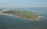
The island is about 5 kilometres (3.1 mi) long and 1.5 kilometre (0.93205910497471 mi) wide. It covers an area of 6.5 square kilometres (2.5 sq mi) and has a population of around 600 people, swelling to about 3,500 during the summer months due to tourism. Tourists (mainly from the Ruhr Area
in North Rhine-Westphalia
) travel to Baltrum to enjoy the countryside of the Lower Saxony Wadden Sea National Park, the beach and attractions such as the indoor swimming pool filled with sea water or a miniature golf course. The highest point on the isalnd is a central coastal dune with an viewing platform on top called Aussichtsdüne in German
and is 19.3 metres (63.3 ft) above sea-level.
as Balteringe meaning either "pasture
" or "[the place of] the sons or followers of Balter" in Old Frisian
. Another assumption is that the name is derived from the Norse
god
Baldr – son of Odin
and Frigg
. In the recent past an ironic version arose, one would be bald 'rum when encircling the island, as the island is small it would not take a long time to walk around Baltrum. Nevetheless the circumference
amounts to about 15 kilometres (9.3 mi).
Strabo
and Pliny the Elder
provide an indication that the island existed since the first century BC and AD. During the era of the East Frisian chieftains, from 1350 to 1464, the East Frisian islands belonged to the powerful family tom Brok
. In 1398 Baltrum was mentioned in a document for the first time, when Widzel tom Brok assigned Balteringe (besides the other islands) to Duke Albert I
of Bavaria
and received them back as fief.
In the 17th century Baltrum had an elongated shape similar to the present shape of the barrier island
s Norderney
and Juist
. Through the centuries Baltrum lost a huge amount of land at its west coast due to wind and sea conditions which the extension at the east coast could not compensate. Between 1650 and 1960 the island moved about 5 kilometres (3.1 mi) at its west side to east, whereas the east coast moved only 1.5 kilometre (0.93205910497471 mi) to east. A journey from a committee in 1650 reports that the 14 inhabitants on the island of that time were in jeopardy by the sea. In 1737 there was a village with a church which had to be abandoned due to silt
ing of shifting sand dunes in 1800. The new village, named Western village, was settled down around 800 metres (2,624.7 ft) to the west of the present day west coast (near the present day shoal
Othelloplate in-between Baltrum and Norderney) and in the east there was the Eastern village. A storm surge
in 1825 disrupted the island in several pieces and it became mostly uninhabitable, followed by deserting the Western village.
From 1870 onwards the island was protected against the power of the sea with groyne
s, wooden palisades
and revetment
s. Furthermore are levee
s protecting the built-up area against floodings.
On the island exist no official street names but house numbers, instead. Currently (retrieved 2009), are about 300 numbers assigned to houses. The numbering is based on the date of the house construction in ascending order. So the numbers reveal some history of the buildings on the island. However the numbers do not change if a building is replaced by a newer construction.
in 1876, the tourism grew very slowly. Since 1966 Baltrum has been a seaside health resort approved by the state of Germany
. Two hotels were opened in the end of the 19th century, Hotel Küper in 1892 and Hotel zur Post in 1895. Before the World War II broke out 5,000 to 6,000 people visited Baltrum annually. In 1960 nearly 17,000 tourists showed up and since the 1970s there are over 30,000 people making holidays every year during the peak season. Besides the approximately 500 inhabitants about 3,000 guests are constantly living on the island during the peak seasons exhausting the acceptance capacity of the two small villages. In comparison to the other East Frisian islands the inhabitants of Baltrum supported the tourism latish.
island, because of the traffic ban of all kind of motor vehicles. The only exceptions are vehicles of the volunteer fire department
, an ambulance
, a few wheel loaders
and some machines needed for the coastal protection
. From 1949 until 1985 on Baltrum was the small single track Inselbahn Baltrum which was an unelectrified narrow gauge
railway for baggage and cargo transportation. As the inhabitants dislike the presence of bicycles no bicycle sharing system exists on Baltrum and the tourists are asked not to bring their own bicycles onto the island. The passenger and freight transportation is accomplished by horse-drawn carriages
. The baggage is transported by two-wheeled or four-wheeled cart
s or also carriages.
On Baltrum exists no street names, but the addressing is related to the chronology of the development of the areas meaning that the numbering is geographically independent.
A search and rescue
station is present on Baltrum which is operated by the German Lifeboat Institution
.
independent laid by ferries
owned by the shipping company Baltrum Line, founded in 1928, starting in Neßmersiel
. The journey takes about 30 minutes and depending on the season and tourist season one ferry leaves once up to four times for each direction daily. The baggage is containerized
and transported in the same ferry as the vacationers. The highlights of the passage are the seals
on the shoal
s ahead of Norderney
passed by the ferry. The shipping company manages a bus connection to the train station of Norden
, Lower Saxony. Until 2006 the freight traffic was accomplished with the ferry Baltrum II via the port in Norddeich
, Lower Saxony, but since then is transacted via the port in Neßmersiel. The port of Neßmersiel was inaugurated in 1970 and extended by a cargo wharf
with 35 metres (114.8 ft) in length from April to August 2008 due to the relocation of the freight transportation.
as a guided walk across the mudflat
s taking 2.5 hours.
Barrier island
Barrier islands, a coastal landform and a type of barrier system, are relatively narrow strips of sand that parallel the mainland coast. They usually occur in chains, consisting of anything from a few islands to more than a dozen...
off the coast of East Frisia
East Frisia
East Frisia or Eastern Friesland is a coastal region in the northwest of the German federal state of Lower Saxony....
, in Germany
Germany
Germany , officially the Federal Republic of Germany , is a federal parliamentary republic in Europe. The country consists of 16 states while the capital and largest city is Berlin. Germany covers an area of 357,021 km2 and has a largely temperate seasonal climate...
, and is a municipality in the district of Aurich
Aurich (district)
Aurich is a district in Lower Saxony, Germany. It is bounded by the North Sea, the districts of Wittmund and Leer, and the city of Emden.- History :...
, Lower Saxony
Lower Saxony
Lower Saxony is a German state situated in north-western Germany and is second in area and fourth in population among the sixteen states of Germany...
. It is located in-between the chain of the seven inhabited East Frisian Islands
East Frisian Islands
The East Frisian Islands are a chain of islands in the North Sea, off the coast of East Frisia in Lower Saxony, Germany. The islands extend for some from west to east between the mouths of the Ems and Jade / Weser rivers and lie about 3.5 to 10 km offshore...
. Baltrum is the smallest island in this chain by area and inhabitants.
Geography
It is located in the middle of the island chain known as the East Frisian IslandsEast Frisian Islands
The East Frisian Islands are a chain of islands in the North Sea, off the coast of East Frisia in Lower Saxony, Germany. The islands extend for some from west to east between the mouths of the Ems and Jade / Weser rivers and lie about 3.5 to 10 km offshore...
and is the smallest permanently inhabited island in the chain according to the area and number of inhabitants. The tidal creek
Creek (tidal)
A tidal creek, tidal channel, or estuary is the portion of a stream that is affected by ebb and flow of ocean tides, in the case that the subject stream discharges to an ocean, sea or strait. Thus this portion of the stream has variable salinity and electrical conductivity over the tidal cycle...
Wichter Ee in the west separates Baltrum from Norderney
Norderney
Norderney is one of the seven populated East Frisian Islands off the North Sea coast of Germany. It is also a municipality in the district of Aurich in Lower Saxony....
and the tidal creek Accumer Ee in the east separates it from Langeoog
Langeoog
Langeoog is one of the seven inhabited East Frisian Islands at the edge of the Lower Saxon Wadden Sea in the southern North Sea, located between Baltrum Island , and Spiekeroog . It is also a municipality in the district of Wittmund in Lower Saxony, Germany. The name Langeoog means Long Island in...
. There are two villages on the island – Ostdorf and Westdorf – although they have essentially merged into one. The ferry for Baltrum departs from the small port near the village of Neßmersiel
Neßmersiel
Neßmersiel belongs to the municipality Dornum in the rural district Aurich in Lower Saxony, Germany. Neßmersiel is located about 5 kilometres northwest of Dornum. From 1867 to 1977, Neßmersiel belonged to Norden ....
(in the parish of Dornum
Dornum
Dornum is a village and a municipality in the East Frisian district of Aurich, in Lower Saxony, Germany. It is situated near the North Sea coast, approx...
) with connection to the train station of Norden
Norden
- Geography :* the Scandinavian name for the Nordic countries.* Norden, Lower Saxony: a town in Lower Saxony, Germany.* Norden Township, Minnesota: a township in Minnesota, United States.* Norden, Greater Manchester: a village near Rochdale, England....
. The island has its own ferry
Ferry
A ferry is a form of transportation, usually a boat, but sometimes a ship, used to carry primarily passengers, and sometimes vehicles and cargo as well, across a body of water. Most ferries operate on regular, frequent, return services...
terminal and a small airstrip
Airport
An airport is a location where aircraft such as fixed-wing aircraft, helicopters, and blimps take off and land. Aircraft may be stored or maintained at an airport...
.
The island is about 5 kilometres (3.1 mi) long and 1.5 kilometre (0.93205910497471 mi) wide. It covers an area of 6.5 square kilometres (2.5 sq mi) and has a population of around 600 people, swelling to about 3,500 during the summer months due to tourism. Tourists (mainly from the Ruhr Area
Ruhr Area
The Ruhr, by German-speaking geographers and historians more accurately called Ruhr district or Ruhr region , is an urban area in North Rhine-Westphalia, Germany. With 4435 km² and a population of some 5.2 million , it is the largest urban agglomeration in Germany...
in North Rhine-Westphalia
North Rhine-Westphalia
North Rhine-Westphalia is the most populous state of Germany, with four of the country's ten largest cities. The state was formed in 1946 as a merger of the northern Rhineland and Westphalia, both formerly part of Prussia. Its capital is Düsseldorf. The state is currently run by a coalition of the...
) travel to Baltrum to enjoy the countryside of the Lower Saxony Wadden Sea National Park, the beach and attractions such as the indoor swimming pool filled with sea water or a miniature golf course. The highest point on the isalnd is a central coastal dune with an viewing platform on top called Aussichtsdüne in German
German language
German is a West Germanic language, related to and classified alongside English and Dutch. With an estimated 90 – 98 million native speakers, German is one of the world's major languages and is the most widely-spoken first language in the European Union....
and is 19.3 metres (63.3 ft) above sea-level.
Etymology
The origin of the name Baltrum is not clearly clarified. In 1398, the island was mentioned for the first time in a document of enfeoffmentEnfeoffment
Under the European feudal system, enfeoffment was the deed by which a person was given land in exchange for a pledge of service. This mechanism was later used to avoid restrictions on the passage of title in land by a system in which a landowner would give land to one person for the use of another...
as Balteringe meaning either "pasture
Pasture
Pasture is land used for grazing. Pasture lands in the narrow sense are enclosed tracts of farmland, grazed by domesticated livestock, such as horses, cattle, sheep or swine. The vegetation of tended pasture, forage, consists mainly of grasses, with an interspersion of legumes and other forbs...
" or "[the place of] the sons or followers of Balter" in Old Frisian
Old Frisian
Old Frisian is a West Germanic language spoken between the 8th and 16th centuries in the area between the Rhine and Weser on the European North Sea coast. The Frisian settlers on the coast of South Jutland also spoke Old Frisian but no medieval texts of this area are known...
. Another assumption is that the name is derived from the Norse
Norse mythology
Norse mythology, a subset of Germanic mythology, is the overall term for the myths, legends and beliefs about supernatural beings of Norse pagans. It flourished prior to the Christianization of Scandinavia, during the Early Middle Ages, and passed into Nordic folklore, with some aspects surviving...
god
Deity
A deity is a recognized preternatural or supernatural immortal being, who may be thought of as holy, divine, or sacred, held in high regard, and respected by believers....
Baldr – son of Odin
Odin
Odin is a major god in Norse mythology and the ruler of Asgard. Homologous with the Anglo-Saxon "Wōden" and the Old High German "Wotan", the name is descended from Proto-Germanic "*Wodanaz" or "*Wōđanaz"....
and Frigg
Frigg
Frigg is a major goddess in Norse paganism, a subset of Germanic paganism. She is said to be the wife of Odin, and is the "foremost among the goddesses" and the queen of Asgard. Frigg appears primarily in Norse mythological stories as a wife and a mother. She is also described as having the power...
. In the recent past an ironic version arose, one would be bald 'rum when encircling the island, as the island is small it would not take a long time to walk around Baltrum. Nevetheless the circumference
Circumference
The circumference is the distance around a closed curve. Circumference is a special perimeter.-Circumference of a circle:The circumference of a circle is the length around it....
amounts to about 15 kilometres (9.3 mi).
History
The geographersGeography
Geography is the science that studies the lands, features, inhabitants, and phenomena of Earth. A literal translation would be "to describe or write about the Earth". The first person to use the word "geography" was Eratosthenes...
Strabo
Strabo
Strabo, also written Strabon was a Greek historian, geographer and philosopher.-Life:Strabo was born to an affluent family from Amaseia in Pontus , a city which he said was situated the approximate equivalent of 75 km from the Black Sea...
and Pliny the Elder
Pliny the Elder
Gaius Plinius Secundus , better known as Pliny the Elder, was a Roman author, naturalist, and natural philosopher, as well as naval and army commander of the early Roman Empire, and personal friend of the emperor Vespasian...
provide an indication that the island existed since the first century BC and AD. During the era of the East Frisian chieftains, from 1350 to 1464, the East Frisian islands belonged to the powerful family tom Brok
Tom Brok
The tom Brok family were a powerful East Frisian line of chieftains, originally from the Norderland on the North Sea coast of Germany. From the second half of the 14th century, the tom Broks tried to gain control of East Frisia over the other chieftain families...
. In 1398 Baltrum was mentioned in a document for the first time, when Widzel tom Brok assigned Balteringe (besides the other islands) to Duke Albert I
Albert I, Duke of Bavaria
Duke Albert I or Albrecht KG was a feudal ruler of the counties of Holland, Hainaut, and Zeeland in the Low Countries...
of Bavaria
Bavaria
Bavaria, formally the Free State of Bavaria is a state of Germany, located in the southeast of Germany. With an area of , it is the largest state by area, forming almost 20% of the total land area of Germany...
and received them back as fief.
In the 17th century Baltrum had an elongated shape similar to the present shape of the barrier island
Barrier island
Barrier islands, a coastal landform and a type of barrier system, are relatively narrow strips of sand that parallel the mainland coast. They usually occur in chains, consisting of anything from a few islands to more than a dozen...
s Norderney
Norderney
Norderney is one of the seven populated East Frisian Islands off the North Sea coast of Germany. It is also a municipality in the district of Aurich in Lower Saxony....
and Juist
Juist
Juist is one of the seven inhabited East Frisian Islands at the edge of the Lower Saxon Wadden Sea in the southern North Sea, located between Borkum Island , Memmert Island and Norderney...
. Through the centuries Baltrum lost a huge amount of land at its west coast due to wind and sea conditions which the extension at the east coast could not compensate. Between 1650 and 1960 the island moved about 5 kilometres (3.1 mi) at its west side to east, whereas the east coast moved only 1.5 kilometre (0.93205910497471 mi) to east. A journey from a committee in 1650 reports that the 14 inhabitants on the island of that time were in jeopardy by the sea. In 1737 there was a village with a church which had to be abandoned due to silt
Silt
Silt is granular material of a size somewhere between sand and clay whose mineral origin is quartz and feldspar. Silt may occur as a soil or as suspended sediment in a surface water body...
ing of shifting sand dunes in 1800. The new village, named Western village, was settled down around 800 metres (2,624.7 ft) to the west of the present day west coast (near the present day shoal
Shoal
Shoal, shoals or shoaling may mean:* Shoal, a sandbank or reef creating shallow water, especially where it forms a hazard to shipping* Shoal draught , of a boat with shallow draught which can pass over some shoals: see Draft...
Othelloplate in-between Baltrum and Norderney) and in the east there was the Eastern village. A storm surge
Storm surge
A storm surge is an offshore rise of water associated with a low pressure weather system, typically tropical cyclones and strong extratropical cyclones. Storm surges are caused primarily by high winds pushing on the ocean's surface. The wind causes the water to pile up higher than the ordinary sea...
in 1825 disrupted the island in several pieces and it became mostly uninhabitable, followed by deserting the Western village.
From 1870 onwards the island was protected against the power of the sea with groyne
Groyne
A groyne is a rigid hydraulic structure built from an ocean shore or from a bank that interrupts water flow and limits the movement of sediment. In the ocean, groynes create beaches, or avoid having them washed away by longshore drift. In a river, groynes prevent erosion and ice-jamming, which...
s, wooden palisades
Palisade
A palisade is a steel or wooden fence or wall of variable height, usually used as a defensive structure.- Typical construction :Typical construction consisted of small or mid sized tree trunks aligned vertically, with no spacing in between. The trunks were sharpened or pointed at the top, and were...
and revetment
Revetment
Revetments, or revêtements , have a variety of meanings in architecture, engineering and art history. In stream restoration, river engineering or coastal management, they are sloping structures placed on banks or cliffs in such a way as to absorb the energy of incoming water...
s. Furthermore are levee
Levee
A levee, levée, dike , embankment, floodbank or stopbank is an elongated naturally occurring ridge or artificially constructed fill or wall, which regulates water levels...
s protecting the built-up area against floodings.
On the island exist no official street names but house numbers, instead. Currently (retrieved 2009), are about 300 numbers assigned to houses. The numbering is based on the date of the house construction in ascending order. So the numbers reveal some history of the buildings on the island. However the numbers do not change if a building is replaced by a newer construction.
Tourism
Although Baltrum became a seaside resortSeaside resort
A seaside resort is a resort, or resort town, located on the coast. Where a beach is the primary focus for tourists, it may be called a beach resort.- Overview :...
in 1876, the tourism grew very slowly. Since 1966 Baltrum has been a seaside health resort approved by the state of Germany
Germany
Germany , officially the Federal Republic of Germany , is a federal parliamentary republic in Europe. The country consists of 16 states while the capital and largest city is Berlin. Germany covers an area of 357,021 km2 and has a largely temperate seasonal climate...
. Two hotels were opened in the end of the 19th century, Hotel Küper in 1892 and Hotel zur Post in 1895. Before the World War II broke out 5,000 to 6,000 people visited Baltrum annually. In 1960 nearly 17,000 tourists showed up and since the 1970s there are over 30,000 people making holidays every year during the peak season. Besides the approximately 500 inhabitants about 3,000 guests are constantly living on the island during the peak seasons exhausting the acceptance capacity of the two small villages. In comparison to the other East Frisian islands the inhabitants of Baltrum supported the tourism latish.
Points of interest
- Old church of the island: In 1826 the church was built as Lutheran churchLutheranismLutheranism is a major branch of Western Christianity that identifies with the theology of Martin Luther, a German reformer. Luther's efforts to reform the theology and practice of the church launched the Protestant Reformation...
, later used as Catholic church, afterwards as a morgueMorgueA morgue or mortuary is used for the storage of human corpses awaiting identification, or removal for autopsy or disposal by burial, cremation or otherwise...
. In present days it is only used for marriage ceremonies, baptisms and cultural events. - Great Lutheran church of the island: This church was built in the years of 1929–30. Both naveNaveIn Romanesque and Gothic Christian abbey, cathedral basilica and church architecture, the nave is the central approach to the high altar, the main body of the church. "Nave" was probably suggested by the keel shape of its vaulting...
s were attached in 1959, the tower was elevated in 1964–65. - Saint Nicholas church: The foundation block of the Catholic church was laid on Saint Nicholas Day in 1956 and consecratedConsecrationConsecration is the solemn dedication to a special purpose or service, usually religious. The word "consecration" literally means "to associate with the sacred". Persons, places, or things can be consecrated, and the term is used in various ways by different groups...
on Ascension DayFeast of the AscensionThe Solemnity of the Ascension of the Lord is one of the great solemnities, in the Christian liturgical calendar, and commemorates the bodily Ascension of Jesus into heaven. Ascension Day is traditionally celebrated on a Thursday, the fortieth day from Easter day...
in 1957. The church has a closed building used during the winter (winter church) and a thatchingThatchingThatching is the craft of building a roof with dry vegetation such as straw, water reed, sedge , rushes, or heather, layering the vegetation so as to shed water away from the inner roof. It is a very old roofing method and has been used in both tropical and temperate climates...
roofed building used in the summer season (summer church). The winter church has seats for 50 people and the summer church can receive up to 300 people. The constructor of the church was the architect Heinrich Feldwisch-Drentrup from OsnabrückOsnabrückOsnabrück is a city in Lower Saxony, Germany, some 80 km NNE of Dortmund, 45 km NE of Münster, and some 100 km due west of Hanover. It lies in a valley penned between the Wiehen Hills and the northern tip of the Teutoburg Forest...
, the glass windows were created by Margarete Franke. - Historical palisade for protection: The palisadePalisadeA palisade is a steel or wooden fence or wall of variable height, usually used as a defensive structure.- Typical construction :Typical construction consisted of small or mid sized tree trunks aligned vertically, with no spacing in between. The trunks were sharpened or pointed at the top, and were...
for protection is located at the southwestern side. It was positioned in the 1880s and renewed in 1930–31. Nowadays it is only a section of the original palisade in-between the tiny harbor and the western end. It is heritage-protectedCultural Heritage ManagementCultural heritage management is the vocation and practice of managing cultural heritage. It is a branch of cultural resources management , although it also draws on the practices of conservation, restoration, museology, archaeology, history and architecture...
and due to extensive restoration works in 2008 repaired at the western side. - Museum of local history in the old custom house: The museum was opened in the old custom houseCustom HouseA custom house or customs house was a building housing the offices for the government officials who processed the paperwork for the import and export of goods into and out of a country. Customs officials also collected customs duty on imported goods....
by the association of local history of Baltrum on May 24, 2007. The exhibition covers the local and the natural history. - National park museum: Founded in 1987 in the former shedShedA shed is typically a simple, single-storey structure in a back garden or on an allotment that is used for storage, hobbies, or as a workshop....
of the shipping company Baltrum Linie and focuses on the tides.
Traffic
Baltrum is a complete car-freeCar-free movement
The car-free movement is a broad, informal, emergent network of individuals and organizations including social activists, urban planners and others brought together by a shared belief that cars are too dominant in most modern cities...
island, because of the traffic ban of all kind of motor vehicles. The only exceptions are vehicles of the volunteer fire department
Volunteer fire department
See also the Firefighter article and its respective sections regarding VFDs in other countries.A volunteer fire department is a fire department composed of volunteers who perform fire suppression and other related emergency services for a local jurisdiction.The first organized force of...
, an ambulance
Ambulance
An ambulance is a vehicle for transportation of sick or injured people to, from or between places of treatment for an illness or injury, and in some instances will also provide out of hospital medical care to the patient...
, a few wheel loaders
Loader (equipment)
A loader is a heavy equipment machine often used in construction, primarily used to load material into or onto another type of machinery .-Heavy equipment front loaders:A loader A loader is a heavy equipment machine often used in construction, primarily used to load material (such as asphalt,...
and some machines needed for the coastal protection
Coastal management
In some jurisdictions the terms sea defense and coastal protection are used to mean, respectively, defense against flooding and erosion...
. From 1949 until 1985 on Baltrum was the small single track Inselbahn Baltrum which was an unelectrified narrow gauge
Narrow gauge
A narrow gauge railway is a railway that has a track gauge narrower than the of standard gauge railways. Most existing narrow gauge railways have gauges of between and .- Overview :...
railway for baggage and cargo transportation. As the inhabitants dislike the presence of bicycles no bicycle sharing system exists on Baltrum and the tourists are asked not to bring their own bicycles onto the island. The passenger and freight transportation is accomplished by horse-drawn carriages
Carriage
A carriage is a wheeled vehicle for people, usually horse-drawn; litters and sedan chairs are excluded, since they are wheelless vehicles. The carriage is especially designed for private passenger use and for comfort or elegance, though some are also used to transport goods. It may be light,...
. The baggage is transported by two-wheeled or four-wheeled cart
Cart
A cart is a vehicle designed for transport, using two wheels and normally pulled by one or a pair of draught animals. A handcart is pulled or pushed by one or more people...
s or also carriages.
On Baltrum exists no street names, but the addressing is related to the chronology of the development of the areas meaning that the numbering is geographically independent.
A search and rescue
Search and rescue
Search and rescue is the search for and provision of aid to people who are in distress or imminent danger.The general field of search and rescue includes many specialty sub-fields, mostly based upon terrain considerations...
station is present on Baltrum which is operated by the German Lifeboat Institution
Deutsche Gesellschaft zur Rettung Schiffbrüchiger
The Deutsche Gesellschaft zur Rettung Schiffbrüchiger or DGzRS is responsible for Search and Rescue in German territorial waters in the North Sea and the Baltic Sea, including the Exclusive Economic Zone.The headquarters and...
.
Ferry services
Baltrum is tidalTide
Tides are the rise and fall of sea levels caused by the combined effects of the gravitational forces exerted by the moon and the sun and the rotation of the Earth....
independent laid by ferries
Ferry
A ferry is a form of transportation, usually a boat, but sometimes a ship, used to carry primarily passengers, and sometimes vehicles and cargo as well, across a body of water. Most ferries operate on regular, frequent, return services...
owned by the shipping company Baltrum Line, founded in 1928, starting in Neßmersiel
Neßmersiel
Neßmersiel belongs to the municipality Dornum in the rural district Aurich in Lower Saxony, Germany. Neßmersiel is located about 5 kilometres northwest of Dornum. From 1867 to 1977, Neßmersiel belonged to Norden ....
. The journey takes about 30 minutes and depending on the season and tourist season one ferry leaves once up to four times for each direction daily. The baggage is containerized
Containerization
Containerization is a system of freight transport based on a range of steel intermodal containers...
and transported in the same ferry as the vacationers. The highlights of the passage are the seals
Harbor Seal
The harbor seal , also known as the common seal, is a true seal found along temperate and Arctic marine coastlines of the Northern Hemisphere...
on the shoal
Shoal
Shoal, shoals or shoaling may mean:* Shoal, a sandbank or reef creating shallow water, especially where it forms a hazard to shipping* Shoal draught , of a boat with shallow draught which can pass over some shoals: see Draft...
s ahead of Norderney
Norderney
Norderney is one of the seven populated East Frisian Islands off the North Sea coast of Germany. It is also a municipality in the district of Aurich in Lower Saxony....
passed by the ferry. The shipping company manages a bus connection to the train station of Norden
Norden, Lower Saxony
Norden is a town in the district of Aurich, in Lower Saxony, Germany. It is situated on the North Sea shore, in East Frisia.-External links:* *...
, Lower Saxony. Until 2006 the freight traffic was accomplished with the ferry Baltrum II via the port in Norddeich
Norddeich (Norden)
Norddeich is a village in the borough of Norden in north Germany with 1,734 inhabitants. It lies in northwestern East Frisia on the North Sea coast....
, Lower Saxony, but since then is transacted via the port in Neßmersiel. The port of Neßmersiel was inaugurated in 1970 and extended by a cargo wharf
Wharf
A wharf or quay is a structure on the shore of a harbor where ships may dock to load and unload cargo or passengers.Such a structure includes one or more berths , and may also include piers, warehouses, or other facilities necessary for handling the ships.A wharf commonly comprises a fixed...
with 35 metres (114.8 ft) in length from April to August 2008 due to the relocation of the freight transportation.
Airport
The airstrip on Baltrum achieves the connection by air to Norddeich.Walk
At the event of low water Baltrum is reachable from the port of NeßmersielNeßmersiel
Neßmersiel belongs to the municipality Dornum in the rural district Aurich in Lower Saxony, Germany. Neßmersiel is located about 5 kilometres northwest of Dornum. From 1867 to 1977, Neßmersiel belonged to Norden ....
as a guided walk across the mudflat
Mudflat
Mudflats or mud flats, also known as tidal flats, are coastal wetlands that form when mud is deposited by tides or rivers. They are found in sheltered areas such as bays, bayous, lagoons, and estuaries. Mudflats may be viewed geologically as exposed layers of bay mud, resulting from deposition of...
s taking 2.5 hours.