

Utah State Route 58
Encyclopedia
Interstate 80 Business is a business loop
of Interstate 80
(I-80) that is 2.26 miles (3.6 km) long and serves as the main street for the towns of West Wendover
, Nevada
and Wendover
, Utah
along a roadway named Wendover Boulevard. Wendover Boulevard was originally part of U.S. Route 40
(US 40), which connected California to New Jersey via Nevada and Utah. A portion of the Nevada segment is concurrent
with U.S. Route 93 Alternate
(US 93 Alt.), and the entire portion in Utah is coterminous with Utah State Route 58 (SR-58). The Nevada Department of Transportation
(Nevada DOT) applied for the business loop designation in the early 1980s but the designation has never been approved, despite signs being posted in both states. Between July 1976 and 1993, BL-80 was concurrent with State Route 224 (SR 224) in Nevada.
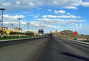
until it intersects and turns east onto Wendover Boulevard. Just west of the intersection, the highway passes the West Wendover City Hall, which houses the West Wendover Municipal Court and Eastline Justice Court. Traveling east along Wendover Boulevard, BL-80 passes by the Peppermill
casino, the West Wendover Visitors Center and Scobie Park. US 93 Alt. turns south towards Ely
, while BL-80 continues east until it reaches the Montego Bay Resort
and Wendover Nugget
casinos. The casinos are connected via a sky bridge
that allows pedestrian access between the hotels without crossing the highway. A line painted on the street marks the Nevada–Utah border. At the border, BL-80 becomes coterminous with Utah State Route 58 for the final stretch through Wendover, Utah.
BL-80 continues to the east past Aria Boulevard, which to the north connects to I-80, and to the south leads to the historic Wendover Air Force Base
, where the Enola Gay
was stationed. The highway briefly parallels the Shafter Subdivision
of the Union Pacific Railroad
's Central Corridor
, which was formerly part of the Feather River Route
of the Western Pacific Railroad
. As the highway travels east towards a half trumpet interchange with I-80, the number of lanes drops from five to two. Traffic from BL-80 can access eastbound I-80 or turn off onto Frontage Road; however, to access westbound I-80, travelers must continue eastbound until the next exit and turn around. Traffic into Wendover can access BL-80 from both directions of I-80, and from Frontage Road.
The Utah segment of BL-80 is codified into Utah law as Utah Code §72-4-111. Every year, the Utah Department of Transportation (UDOT) conducts a series of surveys on its highways to measure traffic volume. This is expressed in terms of average annual daily traffic (AADT), which is a measure of average traffic volume for any day of the year. In 2009, UDOT calculated that 2,370 cars traveled on BL-80 at the state line. This is a significant decrease from the traffic counts earlier in the decade, which measured 11,205 cars in 2006, 10,345 cars in 2005, and 13,840 cars in 2004. Twenty-one percent of this traffic consists of trucks.
was completed through Wendover. Then governors George H. Dern of Utah and James G. Scrugham
of Nevada, as well as the Secretary of Agriculture William M. Jardine were present to open the highway. Bill Smith and Herman Eckstein opened a filling station at the present location of the Wendover Nugget Casino at a cost of $500 early in 1926. To welcome travelers to his station, he installed a light bulb at the top of a tall pole, which served as the only light in the desert. The Lincoln Highway
was routed to follow the Victory Highway through the region by an order of the Lincoln Highway Association executive committee on October 18, 1926.
Wendover Boulevard was numbered US 40
through the cities of West Wendover and Wendover beginning in 1926. US 40 was the major thoroughfare between San Francisco, California
, in the west and Atlantic City, New Jersey
, in the east. US 40 was routed along the Wendover Cut-off
, now known as Frontage Road, which was retained as a service road after the completion of the I-80. The US 40 designation was removed by 1976 or 1977, when I-80 was completed through the area. The designation of roadway now numbered US 93 Alt. has changed twice in the past. Between 1932 and 1953, it was designated , and between 1954 and either 1978 and 1979, it was designated US 50 Alt.
 Two other roads have been numbered Utah SR-58 in the past. The first route designated SR-58 was formed in 1945 between SR-36
and Clover, but was decommissioned in 1953. The second road to use the designation was formed in 1965 between I-15
in New Harmony
back to I-15 via Kanarraville
, but that road was decommissioned in 1969. The current SR-58 was codified into Utah law in 1969 between the state line and the junction with Frontage Road, which was formerly US 40. Wendover Boulevard between US 93 Alt. and the state line was designated SR 224 between July 1, 1976, and April 28, 1993, when the highway was transferred to Elko County.
Even though BL-80 is signed in both Nevada and Utah, the route has never been officially designated a business loop by the American Association of State Highway and Transportation Officials
(AASHTO) or by the Utah State Legislature
. Nevada DOT applied for the designation, but in July 1982 the application was deferred by AASHTO until Utah submitted a request for a business loop. No such request has ever been submitted.
Prior to 2007, BL-80 was the only connection to the city of Wendover from Utah. However, a new partial diamond interchange
, which allows traffic from I-80 to exit going westbound and for traffic to enter I-80 eastbound, at Aria Boulevard was constructed. The Aria Boulevard interchange was first planned in 2005, and was completed with out using any federal funding.
In 2007, the City of West Wendover had two historical markers installed along BL-80, one at the state line, and the other at the intersection of US 93 Alt. to commemorate the Victory Highway and US 40.
Business route
A business route in the United States and Canada is a short special route connected to a parent numbered highway at its beginning, then routed through the central business district of a nearby city or town, and finally reconnecting with the same parent numbered highway again at its...
of Interstate 80
Interstate 80
Interstate 80 is the second-longest Interstate Highway in the United States, following Interstate 90. It is a transcontinental artery running from downtown San Francisco, California to Teaneck, New Jersey in the New York City Metropolitan Area...
(I-80) that is 2.26 miles (3.6 km) long and serves as the main street for the towns of West Wendover
West Wendover, Nevada
West Wendover is a city in Elko County, Nevada, United States. The population was 4,721 at the 2000 census. It is part of the Elko Micropolitan Statistical Area. West Wendover is located on the eastern border of Nevada and the western edge of the Great Salt Lake Desert, and is contiguous with...
, Nevada
Nevada
Nevada is a state in the western, mountain west, and southwestern regions of the United States. With an area of and a population of about 2.7 million, it is the 7th-largest and 35th-most populous state. Over two-thirds of Nevada's people live in the Las Vegas metropolitan area, which contains its...
and Wendover
Wendover, Utah
Wendover is a city in Tooele County, Utah, United States. It is part of the Elko Micropolitan Statistical Area. The population was 1,537 at the 2000 census, with a 2006 estimated population of 1,632....
, Utah
Utah
Utah is a state in the Western United States. It was the 45th state to join the Union, on January 4, 1896. Approximately 80% of Utah's 2,763,885 people live along the Wasatch Front, centering on Salt Lake City. This leaves vast expanses of the state nearly uninhabited, making the population the...
along a roadway named Wendover Boulevard. Wendover Boulevard was originally part of U.S. Route 40
U.S. Route 40
U.S. Route 40 is an east–west United States highway. As with most routes whose numbers end in a zero, U.S. 40 once traversed the entire United States. It is one of the original 1920s U.S. Highways, and its first termini were San Francisco, California, and Atlantic City, New Jersey...
(US 40), which connected California to New Jersey via Nevada and Utah. A portion of the Nevada segment is concurrent
Concurrency (road)
A concurrency, overlap, or coincidence in a road network is an instance of one physical road bearing two or more different highway, motorway, or other route numbers...
with U.S. Route 93 Alternate
U.S. Route 93 Alternate (Nevada)
In the U.S. state of Nevada, U.S. Route 93 Alternate is an alternate route of U.S. Route 93 located in the northeast part of the state. It connects Lages Station to Wells via the town of West Wendover....
(US 93 Alt.), and the entire portion in Utah is coterminous with Utah State Route 58 (SR-58). The Nevada Department of Transportation
Nevada Department of Transportation
The Nevada Department of Transportation is a government agency in the U.S. state of Nevada. NDOT is responsible for maintaining and improving Nevada's highway system, which includes U.S. highways and Interstate highways within the state's boundaries. The department is notable for its...
(Nevada DOT) applied for the business loop designation in the early 1980s but the designation has never been approved, despite signs being posted in both states. Between July 1976 and 1993, BL-80 was concurrent with State Route 224 (SR 224) in Nevada.
Route description
Starting at the easternmost Nevada exit of I-80, BL-80 heads south, concurrent with US 93 Alt.U.S. Route 93 Alternate (Nevada)
In the U.S. state of Nevada, U.S. Route 93 Alternate is an alternate route of U.S. Route 93 located in the northeast part of the state. It connects Lages Station to Wells via the town of West Wendover....
until it intersects and turns east onto Wendover Boulevard. Just west of the intersection, the highway passes the West Wendover City Hall, which houses the West Wendover Municipal Court and Eastline Justice Court. Traveling east along Wendover Boulevard, BL-80 passes by the Peppermill
Wendover Peppermill
The Wendover Peppermill is a hotel and casino located in West Wendover, Nevada. This casino as well as the Rainbow casino, and the Montego Bay are owned by Peppermill Casinos, Inc.-History:...
casino, the West Wendover Visitors Center and Scobie Park. US 93 Alt. turns south towards Ely
Ely, Nevada
Ely is the largest city and county seat of White Pine County, Nevada, United States. Ely was founded as a stagecoach station along the Pony Express and Central Overland Route. Ely's mining boom came later than the other towns along US 50, with the discovery of copper in 1906...
, while BL-80 continues east until it reaches the Montego Bay Resort
Montego Bay Resort
The Montego Bay Resort is a hotel and casino located in West Wendover, Nevada. In addition to the Wendover Nugget, it is located right on the border line between Utah and Nevada just south of Interstate 80...
and Wendover Nugget
Wendover Nugget
The Wendover Nugget is a hotel and casino located in West Wendover, Nevada. In addition to the Montego Bay Resort, it is located right on the border line between Utah and Nevada...
casinos. The casinos are connected via a sky bridge
Skyway
In an urban setting, a skyway, catwalk, sky bridge, or skywalk is a type of pedway consisting of an enclosed or covered bridge between two buildings. This protects pedestrians from the weather. These skyways are usually owned by businesses, and are therefore not public spaces...
that allows pedestrian access between the hotels without crossing the highway. A line painted on the street marks the Nevada–Utah border. At the border, BL-80 becomes coterminous with Utah State Route 58 for the final stretch through Wendover, Utah.
BL-80 continues to the east past Aria Boulevard, which to the north connects to I-80, and to the south leads to the historic Wendover Air Force Base
Wendover Air Force Base
Wendover Air Force Base is a former United States Air Force base in Utah now known as Wendover Airport. During World War II it was a training base for B-17 and B-24 bomber crews. It was the training site of the 509th Composite Group, the B-29 unit which dropped the Hiroshima and Nagasaki atomic bombs...
, where the Enola Gay
Enola Gay
Enola Gay is a Boeing B-29 Superfortress bomber, named after Enola Gay Tibbets, mother of the pilot, then-Colonel Paul Tibbets. On August 6, 1945, during the final stages of World War II, it became the first aircraft to drop an atomic bomb as a weapon of war...
was stationed. The highway briefly parallels the Shafter Subdivision
Shafter Subdivision
The Shafter Subdivision is a rail line owned and operated by the Union Pacific Railroad as part of the Central Corridor in the U.S. states of Nevada and Utah. The line begins in Elko, and travels east to the rail siding of Smelter in Utah, at the junction with the Lynndyl Subdivision of the former...
of the Union Pacific Railroad
Union Pacific Railroad
The Union Pacific Railroad , headquartered in Omaha, Nebraska, is the largest railroad network in the United States. James R. Young is president, CEO and Chairman....
's Central Corridor
Central Corridor (Union Pacific Railroad)
The Central Corridor is a rail line operated by the Union Pacific Railroad from near Winnemucca, Nevada to Denver, Colorado in the western United States. The line is in use for freight, and provides the route of the California Zephyr. The BNSF Railway has trackage rights on the entire line. The...
, which was formerly part of the Feather River Route
Feather River Route
The Feather River Route is a rail line that was built and operated by the Western Pacific Railroad. It was constructed between 1906 and 1909, and connects the cities of Oakland, California, and Salt Lake City, Utah...
of the Western Pacific Railroad
Western Pacific Railroad
The Western Pacific Railroad was a Class I railroad in the United States. It was formed in 1903 as an attempt to break the near-monopoly the Southern Pacific Railroad had on rail service into northern California...
. As the highway travels east towards a half trumpet interchange with I-80, the number of lanes drops from five to two. Traffic from BL-80 can access eastbound I-80 or turn off onto Frontage Road; however, to access westbound I-80, travelers must continue eastbound until the next exit and turn around. Traffic into Wendover can access BL-80 from both directions of I-80, and from Frontage Road.
The Utah segment of BL-80 is codified into Utah law as Utah Code §72-4-111. Every year, the Utah Department of Transportation (UDOT) conducts a series of surveys on its highways to measure traffic volume. This is expressed in terms of average annual daily traffic (AADT), which is a measure of average traffic volume for any day of the year. In 2009, UDOT calculated that 2,370 cars traveled on BL-80 at the state line. This is a significant decrease from the traffic counts earlier in the decade, which measured 11,205 cars in 2006, 10,345 cars in 2005, and 13,840 cars in 2004. Twenty-one percent of this traffic consists of trucks.
History
A roadway, now named Wendover Boulevard, has existed since June 23, 1925 when the Victory HighwayVictory Highway
The Victory Highway was an auto trail across the United States between New York City and San Francisco, roughly equivalent to the present U.S. Route 40.-History:...
was completed through Wendover. Then governors George H. Dern of Utah and James G. Scrugham
James G. Scrugham
James Graves Scrugham was an American politician. He was a Representative, a Senator, and the 14th Governor of the U.S. state of Nevada. He was a member of the Democratic Party.-Biography:...
of Nevada, as well as the Secretary of Agriculture William M. Jardine were present to open the highway. Bill Smith and Herman Eckstein opened a filling station at the present location of the Wendover Nugget Casino at a cost of $500 early in 1926. To welcome travelers to his station, he installed a light bulb at the top of a tall pole, which served as the only light in the desert. The Lincoln Highway
Lincoln Highway
The Lincoln Highway was the first road across the United States of America.Conceived and promoted by entrepreneur Carl G. Fisher, the Lincoln Highway spanned coast-to-coast from Times Square in New York City to Lincoln Park in San Francisco, originally through 13 states: New York, New Jersey,...
was routed to follow the Victory Highway through the region by an order of the Lincoln Highway Association executive committee on October 18, 1926.
Wendover Boulevard was numbered US 40
U.S. Route 40
U.S. Route 40 is an east–west United States highway. As with most routes whose numbers end in a zero, U.S. 40 once traversed the entire United States. It is one of the original 1920s U.S. Highways, and its first termini were San Francisco, California, and Atlantic City, New Jersey...
through the cities of West Wendover and Wendover beginning in 1926. US 40 was the major thoroughfare between San Francisco, California
San Francisco, California
San Francisco , officially the City and County of San Francisco, is the financial, cultural, and transportation center of the San Francisco Bay Area, a region of 7.15 million people which includes San Jose and Oakland...
, in the west and Atlantic City, New Jersey
Atlantic City, New Jersey
Atlantic City is a city in Atlantic County, New Jersey, United States, and a nationally renowned resort city for gambling, shopping and fine dining. The city also served as the inspiration for the American version of the board game Monopoly. Atlantic City is located on Absecon Island on the coast...
, in the east. US 40 was routed along the Wendover Cut-off
Wendover Cut-off
The Wendover Cut-off, also called the Wendover Road or Wendover Route, was a section of two-lane highway in the western part of the U.S. state of Utah. Stretching 41.4 miles from Wendover to Knolls across the Great Salt Lake Desert, just north of the Western Pacific Railroad, it was an important...
, now known as Frontage Road, which was retained as a service road after the completion of the I-80. The US 40 designation was removed by 1976 or 1977, when I-80 was completed through the area. The designation of roadway now numbered US 93 Alt. has changed twice in the past. Between 1932 and 1953, it was designated , and between 1954 and either 1978 and 1979, it was designated US 50 Alt.
Utah State Route 36
State Route 36 is a highway in northern Utah connecting US-6 in northern Juab County to I-80 in northern Tooele County.-Route description:From its southern terminus west of Eureka, SR-36 heads northwest until Vernon, where it turns north...
and Clover, but was decommissioned in 1953. The second road to use the designation was formed in 1965 between I-15
Interstate 15 in Utah
In the U.S. state of Utah, Interstate 15 runs north–south through the southwestern and central portions of the state, passing through many of the population centers of that state, including St. George, Provo, Salt Lake City, and Ogden, the latter three being part of the urban area known as...
in New Harmony
New Harmony, Utah
New Harmony is a town in Washington County, Utah, United States. The population was 190 at the 2000 census. It was originally settled as part of efforts to mine and refine iron in the area. Settlers built a crude foundry in 1852, but abandoned it soon after due to transport and logistics issues...
back to I-15 via Kanarraville
Kanarraville, Utah
Kanarraville is a town in Iron County, Utah, United States. The population was 311 at the 2000 census.-Geography:Kanarraville is located at ....
, but that road was decommissioned in 1969. The current SR-58 was codified into Utah law in 1969 between the state line and the junction with Frontage Road, which was formerly US 40. Wendover Boulevard between US 93 Alt. and the state line was designated SR 224 between July 1, 1976, and April 28, 1993, when the highway was transferred to Elko County.
Even though BL-80 is signed in both Nevada and Utah, the route has never been officially designated a business loop by the American Association of State Highway and Transportation Officials
American Association of State Highway and Transportation Officials
AASHTO, the American Association of State Highway and Transportation Officials, is a standards setting body which publishes specifications, test protocols and guidelines which are used in highway design and construction throughout the United States...
(AASHTO) or by the Utah State Legislature
Utah State Legislature
The Utah State Legislature is the state legislature of the U.S. state of Utah. It is a bicameral body, comprising the Utah House of Representatives, with 75 Representatives, and the Utah Senate, with 29 State Senators...
. Nevada DOT applied for the designation, but in July 1982 the application was deferred by AASHTO until Utah submitted a request for a business loop. No such request has ever been submitted.
Prior to 2007, BL-80 was the only connection to the city of Wendover from Utah. However, a new partial diamond interchange
Diamond interchange
A diamond interchange is a common type of road junction, used where a freeway crosses a minor road. The freeway itself is grade-separated from the minor road, one crossing the other over a bridge...
, which allows traffic from I-80 to exit going westbound and for traffic to enter I-80 eastbound, at Aria Boulevard was constructed. The Aria Boulevard interchange was first planned in 2005, and was completed with out using any federal funding.
In 2007, the City of West Wendover had two historical markers installed along BL-80, one at the state line, and the other at the intersection of US 93 Alt. to commemorate the Victory Highway and US 40.
Major intersections
See also
- Interstate 80 Business (Nevada)Interstate 80 Business (Nevada)Interstate 80 Business in the U.S. state of Nevada can refer to one of several designated routes:*Interstate 80 Business *Interstate 80 Business *Interstate 80 Business...
for other Business Routes of Interstate 80 in Nevada