

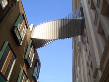
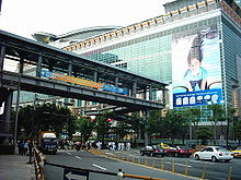
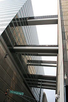
Skyway
Encyclopedia
 |
 |
 |
 |
 |
 |
In an urban
Urban area
An urban area is characterized by higher population density and vast human features in comparison to areas surrounding it. Urban areas may be cities, towns or conurbations, but the term is not commonly extended to rural settlements such as villages and hamlets.Urban areas are created and further...
setting, a skyway, catwalk, sky bridge, or skywalk is a type of pedway
Pedway
Pedways are elevated or underground walkways, often connecting urban high-rises to each other, other buildings, or the street. They provide quick and comfortable movement from building to building, away from traffic and inclement weather. Two of the largest networks of underground walkways are...
consisting of an enclosed
Covered bridge
A covered bridge is a bridge with enclosed sides and a roof, often accommodating only a single lane of traffic. Most covered bridges are wooden; some newer ones are concrete or metal with glass sides...
or covered bridge between two buildings. This protects pedestrians from the weather. These skyways are usually owned by businesses, and are therefore not public space
Public space
A public space is a social space such as a town square that is open and accessible to all, regardless of gender, race, ethnicity, age or socio-economic level. One of the earliest examples of public spaces are commons. For example, no fees or paid tickets are required for entry, nor are the entrants...
s (compare with sidewalk
Sidewalk
A sidewalk, or pavement, footpath, footway, and sometimes platform, is a path along the side of a road. A sidewalk may accommodate moderate changes in grade and is normally separated from the vehicular section by a curb...
). Skyways usually connect on the first few floors above the ground-level floor, though they are sometimes much higher, as in Petronas Towers, SWFC
Shanghai World Financial Center
The most distinctive feature in the design of the building is an aperture at the peak. The original design specified a circular aperture, in diameter, to reduce the stresses of wind pressure, as well as serve as a subtext for the design, since "Chinese mythology represents the earth with a square...
and Kingdom Centre
Kingdom Centre
Kingdom Centre also called Al Mamlaka Tower is a skyscraper located in the city of Riyadh, Saudi Arabia. It is currently the second tallest skyscraper in Saudi Arabia with a height of . It's also the third tallest building with a hole in the world . AL-Mamlka Tower contains a total of 41 floors...
(though this skyway is often referred to as a sky bridge). The space in the buildings connected by skyways is often devoted to retail business, so areas around the skyway may operate as a shopping mall
Shopping mall
A shopping mall, shopping centre, shopping arcade, shopping precinct or simply mall is one or more buildings forming a complex of shops representing merchandisers, with interconnecting walkways enabling visitors to easily walk from unit to unit, along with a parking area — a modern, indoor version...
. Non-commercial areas with closely associated buildings, such as university
University
A university is an institution of higher education and research, which grants academic degrees in a variety of subjects. A university is an organisation that provides both undergraduate education and postgraduate education...
campuses, can often have skyways and/or tunnel
Tunnel
A tunnel is an underground passageway, completely enclosed except for openings for egress, commonly at each end.A tunnel may be for foot or vehicular road traffic, for rail traffic, or for a canal. Some tunnels are aqueducts to supply water for consumption or for hydroelectric stations or are sewers...
s connecting buildings.
The world's largest skyway network – Calgary
Calgary
Calgary is a city in the Province of Alberta, Canada. It is located in the south of the province, in an area of foothills and prairie, approximately east of the front ranges of the Canadian Rockies...
, Alberta
Alberta
Alberta is a province of Canada. It had an estimated population of 3.7 million in 2010 making it the most populous of Canada's three prairie provinces...
's "+15 Walkway
+15
The Plus 15 or +15 Skyway network in Calgary, Alberta, Canada, is the world's most extensive pedestrian skywalk system with a total length of and 59 bridges. The system is so named because the skywalks are approximately 15 feet above street level...
" system – has a total length of 16 km (9.9 mi). However, the system is discontinuous, and it does not connect every downtown building. The largest continuous network of skyways – the Minneapolis Skyway System
Minneapolis Skyway System
The Minneapolis Skyway System is an interlinked collection of enclosed pedestrian footbridges that connects various buildings in Downtown Minneapolis enabling people to walk in a climate-controlled environment...
– spans 8 miles (12.9 km) connecting 69 blocks in downtown Minneapolis.
Other cities in the Midwest, such as Des Moines, Cedar Rapids, Rochester
Rochester, Minnesota
Rochester is a city in the U.S. state of Minnesota and is the county seat of Olmsted County. Located on both banks of the Zumbro River, The city has a population of 106,769 according to the 2010 United States Census, making it Minnesota's third-largest city and the largest outside of the...
, and Saint Paul
Saint Paul, Minnesota
Saint Paul is the capital and second-most populous city of the U.S. state of Minnesota. The city lies mostly on the east bank of the Mississippi River in the area surrounding its point of confluence with the Minnesota River, and adjoins Minneapolis, the state's largest city...
also have significant skyway systems. On a smaller scale, terminals
Airport terminal
An airport terminal is a building at an airport where passengers transfer between ground transportation and the facilities that allow them to board and disembark from aircraft....
of large airport
Airport
An airport is a location where aircraft such as fixed-wing aircraft, helicopters, and blimps take off and land. Aircraft may be stored or maintained at an airport...
s are often connected by skywalk systems, as at Manchester Airport, United Kingdom
United Kingdom
The United Kingdom of Great Britain and Northern IrelandIn the United Kingdom and Dependencies, other languages have been officially recognised as legitimate autochthonous languages under the European Charter for Regional or Minority Languages...
.
The Mumbai Skywalk Project
Mumbai Skywalk Project
The Mumbai Skywalk Project is a series of skyways for pedestrian use in the Mumbai Metropolitan Region. The skywalks connect Mumbai Suburban Railway stations or other high-concentration commercial areas with various heavily targeted destinations...
is a discontinuous system of 50 skywalks planned in the Mumbai Metropolitan Region
Mumbai Metropolitan Region
The Mumbai Metropolitan Region /Mumbai Metropolitan Area is the metropolitan area consisting of the metropolis of Mumbai and its satellite towns. Developing over a period of about 20 years, it consists of seven municipal corporations and fifteen smaller municipal councils...
, each 1 to 2 km in length. When completed, the system will be the largest skyway system in the world. The first of these is a 1.3km (0.8mi) long skywalk connecting the suburban regions of Bandra and Kurla
Kurla
Kurla is a suburb of Mumbai. It is also the name of one the busiest railway stations on the Mumbai suburban railway on the central and harbour railway lines of Mumbai...
.
Some cities have the equivalent of a skyway underground, and many locales have mixed subway/skyway systems; see underground city
Underground city
An Underground city is a series of linked subterranean spaces that may provide a defensive refuge; a place for living, working or shopping; a transit system; mausolea; wine or storage cellars; cisterns or drainage channels; or several of these. The term may also refer to a network of tunnels that...
.
Early examples of skywalks
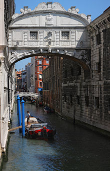
- VeniceVeniceVenice is a city in northern Italy which is renowned for the beauty of its setting, its architecture and its artworks. It is the capital of the Veneto region...
, ItalyItalyItaly , officially the Italian Republic languages]] under the European Charter for Regional or Minority Languages. In each of these, Italy's official name is as follows:;;;;;;;;), is a unitary parliamentary republic in South-Central Europe. To the north it borders France, Switzerland, Austria and...
, Bridge of SighsBridge of SighsThe Bridge of Sighs is a bridge in Venice, northern Italy . The enclosed bridge is made of white limestone and has windows with stone bars. It passes over the Rio di Palazzo and connects the old prisons to the interrogation rooms in the Doge's Palace...
, connects Doge's Palace and prison, 16th century - CopenhagenCopenhagenCopenhagen is the capital and largest city of Denmark, with an urban population of 1,199,224 and a metropolitan population of 1,930,260 . With the completion of the transnational Øresund Bridge in 2000, Copenhagen has become the centre of the increasingly integrating Øresund Region...
, DenmarkDenmarkDenmark is a Scandinavian country in Northern Europe. The countries of Denmark and Greenland, as well as the Faroe Islands, constitute the Kingdom of Denmark . It is the southernmost of the Nordic countries, southwest of Sweden and south of Norway, and bordered to the south by Germany. Denmark...
: skywalk connecting courts building to adjacent uses, 18th century - FaaborgFaaborgFaaborg or Fåborg is a Danish town with a population of 7,178 , located in Faaborg-Midtfyn municipality on the island of Funen. It was formerly the seat of Faaborg municipality. The seat of the new municipality is Ringe...
, FunenFunenFunen , with a size of 2,984 km² , is the third-largest island of Denmark following Zealand and Vendsyssel-Thy, and the 163rd largest island of the world. Funen is located in the central part of the country and has a population of 454,358 inhabitants . The main city is Odense, connected to the...
, Denmark: skywalk in centrum, 18th century
Environmental factors
Besides pedestrian safety and convenience, the chief reasons assigned by urban planners for skywalk development are decrease of traffic congestionTraffic congestion
Traffic congestion is a condition on road networks that occurs as use increases, and is characterized by slower speeds, longer trip times, and increased vehicular queueing. The most common example is the physical use of roads by vehicles. When traffic demand is great enough that the interaction...
, reduction in vehicular air pollution
Roadway air dispersion modeling
Roadway air dispersion modeling is the study of air pollutant transport from a roadway or other linear emitter. Computer models are required to conduct this analysis, because of the complex variables involved, including vehicle emissions, vehicle speed, meteorology, and terrain geometry...
and separation of people from vehicular noise
Roadway noise
Roadway noise is the collective sound energy emanating from motor vehicles. In the USA it contributes more to environmental noise exposure than any other noise source, and is constituted chiefly of engine, tire, aerodynamic and braking elements...
. A number of cities (for example, Spokane, Washington) have given intricate analysis to skywalk systems employing computer model
Computer simulation
A computer simulation, a computer model, or a computational model is a computer program, or network of computers, that attempts to simulate an abstract model of a particular system...
s to optimize skywalk layout.
List of cities with notable systems
| City | Length | Blocks connected | Link |
|---|---|---|---|
| Atlanta, Georgia Atlanta, Georgia Atlanta is the capital and most populous city in the U.S. state of Georgia. According to the 2010 census, Atlanta's population is 420,003. Atlanta is the cultural and economic center of the Atlanta metropolitan area, which is home to 5,268,860 people and is the ninth largest metropolitan area in... |
14 blocks | map | |
| Bangkok Bangkok Bangkok is the capital and largest urban area city in Thailand. It is known in Thai as Krung Thep Maha Nakhon or simply Krung Thep , meaning "city of angels." The full name of Bangkok is Krung Thep Mahanakhon Amon Rattanakosin Mahintharayutthaya Mahadilok Phop Noppharat Ratchathani Burirom... , Thailand Thailand Thailand , officially the Kingdom of Thailand , formerly known as Siam , is a country located at the centre of the Indochina peninsula and Southeast Asia. It is bordered to the north by Burma and Laos, to the east by Laos and Cambodia, to the south by the Gulf of Thailand and Malaysia, and to the... (between Skytrain Bangkok Skytrain The Bangkok Mass Transit System, commonly known as the BTS Skytrain , is an elevated rapid transit system in Bangkok, Thailand. It is operated by Bangkok Mass Transit System Public Company Limited under a concession granted by the Bangkok Metropolitan Administration... Siam Station and Central World) |
> 2 km | ||
| Calgary, Alberta (+15 or +30 Walkway) | 10 miles (16 km) | ~64 blocks | map |
| Cedar Rapids, Iowa Cedar Rapids, Iowa Cedar Rapids is the second largest city in Iowa and is the county seat of Linn County. The city lies on both banks of the Cedar River, north of Iowa City and east of Des Moines, the state's capital and largest city... |
15 blocks | map | |
| Cincinnati, Ohio Cincinnati, Ohio Cincinnati is a city in the U.S. state of Ohio. Cincinnati is the county seat of Hamilton County. Settled in 1788, the city is located to north of the Ohio River at the Ohio-Kentucky border, near Indiana. The population within city limits is 296,943 according to the 2010 census, making it Ohio's... (Skywalk) |
1.3 miles (2.1 km) | 15 blocks | map |
| Dallas, Texas Dallas, Texas Dallas is the third-largest city in Texas and the ninth-largest in the United States. The Dallas-Fort Worth Metroplex is the largest metropolitan area in the South and fourth-largest metropolitan area in the United States... (Skywalks are a part of the larger Dallas Pedestrian Network Dallas Pedestrian Network The Dallas Pedestrian Network is a system of grade-separated walkways covering thirty-six city blocks of downtown Dallas, Texas, USA. The system connects buildings, garages and parks through underground tunnels and above-ground skybridges... ) |
~12 buildings | map | |
| Des Moines, Iowa Des Moines, Iowa Des Moines is the capital and the most populous city in the US state of Iowa. It is also the county seat of Polk County. A small portion of the city extends into Warren County. It was incorporated on September 22, 1851, as Fort Des Moines which was shortened to "Des Moines" in 1857... (Skywalk) |
4 miles (6.4 km) | 30 blocks | map |
| Detroit, Michigan Detroit, Michigan Detroit is the major city among the primary cultural, financial, and transportation centers in the Metro Detroit area, a region of 5.2 million people. As the seat of Wayne County, the city of Detroit is the largest city in the U.S. state of Michigan and serves as a major port on the Detroit River... |
10 buildings | ~ 8 blocks | map |
| Duluth, Minnesota Duluth, Minnesota Duluth is a port city in the U.S. state of Minnesota and is the county seat of Saint Louis County. The fourth largest city in Minnesota, Duluth had a total population of 86,265 in the 2010 census. Duluth is also the second largest city that is located on Lake Superior after Thunder Bay, Ontario,... (Skywalk) |
~17 blocks | map | |
| Edmonton, Alberta (Edmonton Pedway Edmonton Pedway The Edmonton Pedway system is a network connecting office buildings, shopping centres, and parkades in downtown Edmonton, Alberta, Canada. It consists of approximately of year-round climate-controlled underground tunnels and walkways between the second floors of buildings approximately above... ) |
~13 blocks | map | |
| Fargo, North Dakota Fargo, North Dakota Fargo is the largest city in the U.S. state of North Dakota and the county seat of Cass County. In 2010, its population was 105,549, and it had an estimated metropolitan population of 208,777... |
|||
| Grand Rapids, MI (Skywalk) | > 1 mile (1.7 km) | 7 blocks – connects 12,000-seat VanAndel Arena, JW Marriott, Amway Grand Plaza and Marriott Courtyard hotels as well as 1000000 sq ft (92,903 m²) DeVos Place Convention Center | http://www.experiencegr.com/ |
| Hong Kong Hong Kong Hong Kong is one of two Special Administrative Regions of the People's Republic of China , the other being Macau. A city-state situated on China's south coast and enclosed by the Pearl River Delta and South China Sea, it is renowned for its expansive skyline and deep natural harbour... (footbridges, including the Central Elevated Walkway Central Elevated Walkway The Central Elevated Walkway is an extensive footbridge network spanning Admiralty and Central, near Victoria Harbour in Hong Kong.The system was built in phases by the Hong Kong Government and various developers, such as Hongkong Land, Jardine Matheson Holdings and Shun Tak Holdings. It has... ) |
|||
| Houston (skyways are a small part of the larger Houston Downtown Tunnel System Houston Downtown Tunnel System The Houston tunnel system is a system of tunnels below Houston's downtown street system. The system comprises approximately of tunnels and forms a network of subterranean, climate-controlled, pedestrian walkways that link 95 full city blocks... ) |
> 6 miles including tunnels | ~35 blocks (95 total) | map |
| Indianapolis, IN (Skywalk) | Connects Indiana Convention Center Indiana Convention Center The Indiana Convention Center is a convention center located in Downtown Indianapolis, Indiana. It contains over of open exhibit space and almost of group meeting space. It was finished in late 1983 along with the Hoosier Dome , which it was connected to prior the Dome's deconstruction in 2008.... , Lucas Oil Stadium Lucas Oil Stadium Lucas Oil Stadium is a multi-purpose sports stadium in Downtown Indianapolis, Indiana. The stadium celebrated its grand opening on August 24, 2008, and its ribbon-cutting ceremony August 16, 2008. It replaced the RCA Dome as the home field of the NFL's Indianapolis Colts. The stadium was built to... , Circle Centre Mall, Indianapolis Union Station, Indiana Statehouse, and 12 hotels |
||
| Kansas City Kansas City, Missouri Kansas City, Missouri is the largest city in the U.S. state of Missouri and is the anchor city of the Kansas City Metropolitan Area, the second largest metropolitan area in Missouri. It encompasses in parts of Jackson, Clay, Cass, and Platte counties... (Crown Center) |
|||
| Kuala Lumpur Kuala Lumpur Kuala Lumpur is the capital and the second largest city in Malaysia by population. The city proper, making up an area of , has a population of 1.4 million as of 2010. Greater Kuala Lumpur, also known as the Klang Valley, is an urban agglomeration of 7.2 million... , Malaysia (Petronas Twin Towers Petronas Twin Towers The Petronas Towers are skyscrapers and twin towers in Kuala Lumpur, Malaysia... ) |
170 m above the ground and 58 m long | between the two towers on 41st and 42nd floors, world's highest 2-story bridge | |
| London London London is the capital city of :England and the :United Kingdom, the largest metropolitan area in the United Kingdom, and the largest urban zone in the European Union by most measures. Located on the River Thames, London has been a major settlement for two millennia, its history going back to its... , Barbican Estate Barbican Estate The Barbican Estate is a residential estate built during the 1960s and the 1970s in the City of London, in an area once devastated by World War II bombings and today densely populated by financial institutions... and London Wall London Wall London Wall was the defensive wall first built by the Romans around Londinium, their strategically important port town on the River Thames in what is now the United Kingdom, and subsequently maintained until the 18th century. It is now the name of a road in the City of London running along part of... |
map | ||
| Melbourne Melbourne Melbourne is the capital and most populous city in the state of Victoria, and the second most populous city in Australia. The Melbourne City Centre is the hub of the greater metropolitan area and the Census statistical division—of which "Melbourne" is the common name. As of June 2009, the greater... , Australia Australia Australia , officially the Commonwealth of Australia, is a country in the Southern Hemisphere comprising the mainland of the Australian continent, the island of Tasmania, and numerous smaller islands in the Indian and Pacific Oceans. It is the world's sixth-largest country by total area... |
4 blocks & Airport | ||
| Milwaukee, Wisconsin | Empire building, Chase tower, Grand Avenue mall, Federal building, Hyatt Regency, Hilton, Midwest Airlines center | ||
| Minneapolis, Minnesota Minneapolis, Minnesota Minneapolis , nicknamed "City of Lakes" and the "Mill City," is the county seat of Hennepin County, the largest city in the U.S. state of Minnesota, and the 48th largest in the United States... (Minneapolis Skyway System Minneapolis Skyway System The Minneapolis Skyway System is an interlinked collection of enclosed pedestrian footbridges that connects various buildings in Downtown Minneapolis enabling people to walk in a climate-controlled environment... ) |
> 8 miles | ~80 blocks | map |
| Mumbai Metropolitan Region Mumbai Skywalk Project The Mumbai Skywalk Project is a series of skyways for pedestrian use in the Mumbai Metropolitan Region. The skywalks connect Mumbai Suburban Railway stations or other high-concentration commercial areas with various heavily targeted destinations... , India India India , officially the Republic of India , is a country in South Asia. It is the seventh-largest country by geographical area, the second-most populous country with over 1.2 billion people, and the most populous democracy in the world... |
50+ km | Mumbai Suburban Railway Mumbai Suburban Railway The Mumbai Suburban Railway system, part of the public transport system of Mumbai, is provided for by the state-run Indian Railways' two zonal Western Railways and Central Railways. The system carries more than 6.99 million commuters on a daily basis. It has the highest passenger densities of any... stations to important junctions |
MMRDA Skywalks |
| Oklahoma City, Oklahoma Oklahoma City, Oklahoma Oklahoma City is the capital and the largest city in the state of Oklahoma. The county seat of Oklahoma County, the city ranks 31st among United States cities in population. The city's population, from the 2010 census, was 579,999, with a metro-area population of 1,252,987 . In 2010, the Oklahoma... |
~30 buildings | ||
| Paradise, Nevada Paradise, Nevada Paradise is an unincorporated town in the Las Vegas metropolitan area in Clark County, Nevada, United States. The population was 223,167 at the 2010 census... (skyways provided in lieu of street level pedestrian crossings) |
|||
| Pittsburgh, Pennsylvania Pittsburgh, Pennsylvania Pittsburgh is the second-largest city in the US Commonwealth of Pennsylvania and the county seat of Allegheny County. Regionally, it anchors the largest urban area of Appalachia and the Ohio River Valley, and nationally, it is the 22nd-largest urban area in the United States... |
16 blocks | map | |
| Rochester, Minnesota Rochester, Minnesota Rochester is a city in the U.S. state of Minnesota and is the county seat of Olmsted County. Located on both banks of the Zumbro River, The city has a population of 106,769 according to the 2010 United States Census, making it Minnesota's third-largest city and the largest outside of the... (Skyway) |
~17 blocks | map | |
| Rochester, New York Rochester, New York Rochester is a city in Monroe County, New York, south of Lake Ontario in the United States. Known as The World's Image Centre, it was also once known as The Flour City, and more recently as The Flower City... |
20 buildings over 13 blocks | map | |
| Saint Paul, Minnesota Saint Paul, Minnesota Saint Paul is the capital and second-most populous city of the U.S. state of Minnesota. The city lies mostly on the east bank of the Mississippi River in the area surrounding its point of confluence with the Minnesota River, and adjoins Minneapolis, the state's largest city... (Skyway) |
> 5 miles | 30 blocks | map |
| Sioux City, Iowa Sioux City, Iowa Sioux City is a city in Plymouth and Woodbury counties in the western part of the U.S. state of Iowa. The population was 82,684 in the 2010 census, a decline from 85,013 in the 2000 census, which makes it currently the fourth largest city in the state.... |
13 blocks | map | |
| Spokane, Washington Spokane, Washington Spokane is a city located in the Northwestern United States in the state of Washington. It is the largest city of Spokane County of which it is also the county seat, and the metropolitan center of the Inland Northwest region... |
16 blocks | map | |
| Toronto, Ontario | 0.7 km | 2 blocks – Metro Toronto Convention Centre Metro Toronto Convention Centre Metro Toronto Convention Centre , located in Downtown Toronto, Ontario at 255 Front Street West, has of space. The convention centre was completed in October 1984 and is home to the 1330-seat John Bassett Theatre... South Building and Union Station (Toronto) Union Station (Toronto) Union Station is the major inter-city rail station and a major commuter rail hub in Toronto, located on Front Street West and occupying the south side of the block bounded by Bay Street and York Street in the central business district. The station building is owned by the City of Toronto, while the... |
|
| Vilvoorde Vilvoorde Vilvoorde is a Belgian municipality in the Flemish province of Flemish Brabant. The municipality comprises the city of Vilvoorde proper with its two outlying quarters of Koningslo and Houtem and the small town of Peutie... , Belgium Belgium Belgium , officially the Kingdom of Belgium, is a federal state in Western Europe. It is a founding member of the European Union and hosts the EU's headquarters, and those of several other major international organisations such as NATO.Belgium is also a member of, or affiliated to, many... |
1.6 miles (2.7 km) | 9 blocks | 50°54′50"N 4°24′57"E |
| Winnipeg, Manitoba (Winnipeg Walkway Winnipeg Walkway The Winnipeg Walkway System, popularly known as the Winnipeg Skywalk, is a network of pedestrian skyways and tunnels connecting a significant portion of the city centre in Winnipeg, Manitoba, Canada.... ) |
18 blocks | http://www.downtownwinnipegbiz.com/resource/File/DowntownMap_base08.pdf |
More cities and details: Montgomery, Michael R. and Richard Bean, "Market failure, government failure, and the private supply of public goods: the case of climate-controlled walkway networks", in Public Choice, Vol. 99 (1999), pages 403–437, whose abstract may be seen at RePEc: Research Papers in Economics.
See also
- FootbridgeFootbridgeA footbridge or pedestrian bridge is a bridge designed for pedestrians and in some cases cyclists, animal traffic and horse riders, rather than vehicular traffic. Footbridges complement the landscape and can be used decoratively to visually link two distinct areas or to signal a transaction...
- OverpassOverpassAn overpass is a bridge, road, railway or similar structure that crosses over another road or railway...
- Pedestrian separation structurePedestrian separation structureA pedestrian separation structure is any structure that removes pedestrians from a vehicle roadway. This creates a road junction where vehicles and pedestrians do not interact.This can be considered a type of grade separation structure on the road....
- PedwayPedwayPedways are elevated or underground walkways, often connecting urban high-rises to each other, other buildings, or the street. They provide quick and comfortable movement from building to building, away from traffic and inclement weather. Two of the largest networks of underground walkways are...
- Catwalk (disambiguation)Catwalk (disambiguation)A Catwalk is an alternative term for a fashion runway.The same term is also used as the generic name for any raised narrow platform on which people walk, specifically for those allowing workers access to parts of a structure otherwise difficult to reach or to walk on top of a railroad car such as...