

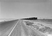
Wendover Cut-off
Encyclopedia
U.S. state
A U.S. state is any one of the 50 federated states of the United States of America that share sovereignty with the federal government. Because of this shared sovereignty, an American is a citizen both of the federal entity and of his or her state of domicile. Four states use the official title of...
of Utah
Utah
Utah is a state in the Western United States. It was the 45th state to join the Union, on January 4, 1896. Approximately 80% of Utah's 2,763,885 people live along the Wasatch Front, centering on Salt Lake City. This leaves vast expanses of the state nearly uninhabited, making the population the...
. Stretching 41.4 miles (66.6 km) from Wendover to Knolls across the Great Salt Lake Desert
Great Salt Lake Desert
The Great Salt Lake Desert is a large dry lake in northern Utah between the Great Salt Lake and the Nevada border which is noted for white sand from evaporite Lake Bonneville salt deposits...
, just north of the Western Pacific Railroad
Western Pacific Railroad
The Western Pacific Railroad was a Class I railroad in the United States. It was formed in 1903 as an attempt to break the near-monopoly the Southern Pacific Railroad had on rail service into northern California...
, it was an important part of the Victory Highway
Victory Highway
The Victory Highway was an auto trail across the United States between New York City and San Francisco, roughly equivalent to the present U.S. Route 40.-History:...
, which became U.S. Route 40 in 1926. The roadway has been bypassed by the four-lane Interstate 80.
History
The preliminary route of the Lincoln HighwayLincoln Highway
The Lincoln Highway was the first road across the United States of America.Conceived and promoted by entrepreneur Carl G. Fisher, the Lincoln Highway spanned coast-to-coast from Times Square in New York City to Lincoln Park in San Francisco, originally through 13 states: New York, New Jersey,...
, the first transcontinental highway in the U.S., was decided in 1913. The highway headed west out of Salt Lake City to Timpie, but turned south there to avoid the desert. An unimproved dirt trail was used through the Skull Valley
Skull Valley
The Skull Valley Indian Reservation is the Goshute Indian reservation located approximately 45 miles southwest of Salt Lake City, Utah. It belongs to the Skull Valley Band of Goshute Indians of Utah, a federally recognized tribe....
to Black Rock on the southeast edge of the desert. There it turned west along the Pony Express Trail, crossing Nevada on the Central Route. This route had been used by overland travelers for about ten years, replacing the Humboldt River Route used by the California Trail
California Trail
The California Trail was an emigrant trail of about across the western half of the North American continent from Missouri River towns to what is now the state of California...
, which went around the north end of the desert, in 1859; travel moved back to the Humboldt River Route in 1869 with the completion of the First Transcontinental Railroad
First Transcontinental Railroad
The First Transcontinental Railroad was a railroad line built in the United States of America between 1863 and 1869 by the Central Pacific Railroad of California and the Union Pacific Railroad that connected its statutory Eastern terminus at Council Bluffs, Iowa/Omaha, Nebraska The First...
. A realignment over Johnson Pass
Johnson Pass
Johnson Creek Summit is a mountain pass through the Kenai Mountains in Southcentral Alaska. It is 23 miles long, and the maximum elevation of the pass is 1450 ft. There is a backpacking trail traversing the entire pass, with access from the south via the Sterling Highway and from the north via...
in 1919 moved the point where the Lincoln Highway turned south east to Mills Junction.
The Western Pacific Railroad
Western Pacific Railroad
The Western Pacific Railroad was a Class I railroad in the United States. It was formed in 1903 as an attempt to break the near-monopoly the Southern Pacific Railroad had on rail service into northern California...
completed a direct route across the desert in 1907, filling a causeway
Causeway
In modern usage, a causeway is a road or railway elevated, usually across a broad body of water or wetland.- Etymology :When first used, the word appeared in a form such as “causey way” making clear its derivation from the earlier form “causey”. This word seems to have come from the same source by...
with rock and gravel at a great cost. Utah began to build the Goodyear Cut-off on the Lincoln Highway in the late 1910s, but never completed the work, instead deciding to push for the more direct Wendover Cut-off in the direction of the Humboldt River Route. (This was designated as part of the Victory Highway
Victory Highway
The Victory Highway was an auto trail across the United States between New York City and San Francisco, roughly equivalent to the present U.S. Route 40.-History:...
in 1921.) One of the primary reasons for this change was commerce. If the Lincoln Highway was improved into Nevada, the Midland Trail
Midland Trail
For the trail's section in West Virginia see: The Midland Trail in West Virginia.The Midland Trail, also called the Roosevelt Midland Trail, was a national auto trail spanning the United States from Washington, D.C...
, which split at Ely, could be used to reach Southern California
Southern California
Southern California is a megaregion, or megapolitan area, in the southern area of the U.S. state of California. Large urban areas include Greater Los Angeles and Greater San Diego. The urban area stretches along the coast from Ventura through the Southland and Inland Empire to San Diego...
, but there was no such branch off the Humboldt River Route. Thus Southern California-bound motorists sticking to improved roads would use the Arrowhead Trail through southwest Utah along the present route of Interstate 15, remaining in the state for about 200 miles (300 km) more. This position was solidified by Utah's decision in 1921 to place the Wendover Cut-off on its network of Federal-aid highways; the Lincoln Highway Association protested, but on June 6, 1923 the Secretary of Agriculture ruled that the Bureau of Public Roads could only accept proposals that the states put forth.
State highway
State highway, state road or state route can refer to one of three related concepts, two of them related to a state or provincial government in a country that is divided into states or provinces :#A...
system on August 24, 1915, and it later became part of State Route 4. (This road was several miles south of the historic Hastings Cutoff
Hastings Cutoff
The Hastings Cutoff was an alternate route for emigrants to travel to California, as proposed by Lansford Hastings.In 1845, Hastings published a guide entitled The Emigrant's Guide to Oregon and California...
.) Construction began on October 1, 1923, and the new highway was opened on July 13, 1925. The 24-foot (7 m) wide causeway was built just to the north of the Western Pacific Railroad's route, using clay fill borrowed from the construction site
Borrow pit
A borrow pit, also known as a sand box, is a term used in construction and civil engineering. It describes an area where material has been dug for use at another location. Borrow pits can be found close to many major construction projects...
. Experience and equipment from the Utah Salduro Company, which operated a salt and potash
Potash
Potash is the common name for various mined and manufactured salts that contain potassium in water-soluble form. In some rare cases, potash can be formed with traces of organic materials such as plant remains, and this was the major historical source for it before the industrial era...
works along the route at Salduro (near the present rest area
Rest area
A rest area, travel plaza, rest stop, or service area is a public facility, located next to a large thoroughfare such as a highway, expressway, or freeway at which drivers and passengers can rest, eat, or refuel without exiting on to secondary roads...
s on I-80), was used to dig up the fill. In order to allow for the passage of water, which covered the salt flats and mud flats in the winter and would otherwise wash out the embankment, 81 culvert
Culvert
A culvert is a device used to channel water. It may be used to allow water to pass underneath a road, railway, or embankment. Culverts can be made of many different materials; steel, polyvinyl chloride and concrete are the most common...
s and six full bridges were built of wood. The final 18-foot (5.5 m) wide surface, a layer of gravel
Gravel
Gravel is composed of unconsolidated rock fragments that have a general particle size range and include size classes from granule- to boulder-sized fragments. Gravel can be sub-categorized into granule and cobble...
, was hauled in on the Western Pacific from its pit 12 miles (19 km) west of Wendover.
Almost the entire Victory Highway became U.S. Route 40 in 1926, while the Lincoln Highway — which carried U.S. Route 30
U.S. Route 30
U.S. Route 30 is an east–west main route of the system of United States Numbered Highways, with the highway traveling across the northern tier of the country. It is the third longest U.S. route, after U.S. Route 20 and U.S. Route 6. The western end of the highway is at Astoria, Oregon; the...
east of Utah — did not receive a number in western Utah, and was part of U.S. Route 50 across Nevada. The final routing of the Lincoln Highway, marked in 1928 by concrete
Concrete
Concrete is a composite construction material, composed of cement and other cementitious materials such as fly ash and slag cement, aggregate , water and chemical admixtures.The word concrete comes from the Latin word...
posts, ran via Wendover, but still turned south along what is now U.S. Route 93 Alternate
U.S. Route 93 Alternate (Nevada)
In the U.S. state of Nevada, U.S. Route 93 Alternate is an alternate route of U.S. Route 93 located in the northeast part of the state. It connects Lages Station to Wells via the town of West Wendover....
to reach the Central Route at Ely; this was finally opened in 1930. The main transcontinental auto route remained on the Victory Highway through Nevada, and has been upgraded as Interstate 80. Neither pre-Wendover alignment of the Lincoln Highway through western Utah can be driven in its entirety, as the Dugway Proving Ground
Dugway Proving Ground
Dugway Proving Ground is a US Army facility located approximately 85 miles southwest of Salt Lake City, Utah in southern Tooele County and just north of Juab County...
was established in 1942 across their path; the route across Nevada is now known as "The Loneliest Road in America".
In addition to US-40, the Wendover Cut-off became part of U.S. Route 50 after the Ely-Wendover connection was completed. It was shifted south to head east from Ely into central Utah in the early 1950s, and the old route via Wendover remained U.S. Route 50 Alternate until 1976. The four-lane Interstate 80 opened just to the north of the old two-lane roadway on December 7, 1969.