

Udon Thani Province
Encyclopedia
Udon Thani is one of the north-eastern
provinces
(changwat) of Thailand
. Neighboring provinces are (from north clockwise) Nong Khai
, Sakon Nakhon
, Kalasin
, Khon Kaen
, Nong Bua Lamphu
and Loei
.
, between the provinces of Khon Kaen
to its south, and Nong Khai
to its north. The city of Udon Thani
, its capital, is served by the railway line that goes northeast from Saraburi through Nakhon Ratchasima
(Khorat
) and Khon Kaen to the border of Laos
on the outskirts of Nong Khai city. Regular direct trains including night sleepers connect the city with Bangkok. The provincial capital, often referred to as just Udon
, is Thailand
's fifth-largest MSA
. In Roman script it is also often spelled Udorn.
Strategically important for the Isan
region's infrastructure, Udon Thani's airport
was raised to international standard in 2006 with the opening of a new terminal to compliment its existing domestic arrival and departure building which is now defunct. At peak times of the year there may be as many as 20 scheduled flights per day operating in and out of Udon Thani, thus making it one of the country's busiest domestic airports. Currently, two budget airlines, Air Asia and Nok Air
, and the national carrier, Thai Airways
, operate from the airport.
Road
The city is bisected by Mittraphap Road, the highway linking Bangkok with the Northeast and Laos. A modern, multi-lane ringroad system enables through traffic to bypass the city centre either to the west or the east. It connects to the airport and to the main roads leading to Nong Bua Lamphu province in the west and to Sakhon Nakhon in the east.
Rail
A station in the city centre on the main Bangkok - Nong Khai line provides the city with regular services to and from the capital and Nong Khai.
Bus
Essential local and city services are provided by songthew truck and pickup truck busses, while regional and long distance destinations are served by regular bus vehicles from several bus terminals. The long distance 'VIP' First Class busses operate from a terminal in the city centre and connect Udon Thani with daytime and overnight routes to Bangkok and many province capitals.
Formerly known as Ban Mak-kaeng, Udon Thani was first settled as a military base led by Prince Prachak to crack down on minority uprising in then north eastern state of Lao Puan. Ban Mak-kaeng has evolved from a rural city eventually into what is known as the present-day Udon Thani, literally the northern city.
The province is most famous for the archeological site Ban Chiang
with its remains of the Bronze age
, located in what is now a hamlet about 85 miles east of Udon. Udon is one of the more bustling markets for agricultural goods in the relatively dry northeast of Thailand, and received its biggest economic boost in the 1960s when the US built the Udon Royal Thai Air Force Base
as a joint-force military base during the Vietnam War
. (the Mel Gibson film Air America refers to Udon and includes shots from the Udon military base.) Udon Thani was also the largest base in the region for CIA's anti-communism
campaign.
The U.S. turned the base over to the Thai military in 1976, but there were three significant after-effects of the base's US presence. First, a number of the natives in the area were paid well and learned English, which helped them become more marketable to the outside world (a significant percentage of the more educated group now work in the Middle East oilfields). Second, the base created ties, including a US Consulate in Udon, which was closed in 1995, and a US Veterans of Foreign Wars
Post. Finally, the base and the consulate caused the city to be viewed as a regional hub, and this impression has continued.
In recent years the province has received international attention due to the discovery of a large potash
deposit in the area and some anticipate that the region will become a major exporter of the mineral. Beginning the mining
process of gaining licensure has been substantially delayed due to public opposition to the mine. Many of the villagers who live directly above the proposed mine site have expressed concern that the company and its Environmental Impact Assessment
(EIA) have not adequately addressed concerns of salinization of groundwater and soil or land subsidence. Both would threaten the economic stability of local communities that rely primarily on income derived from rice farming.
in Thai yak), referring to Thao Kuwane (Vaiśravaṇa
or Kubera
), the god of the North.
The provincial tree is the Teng (Shorea obtusa
), and the provincial flower is the Flame of the forest (Butea monosperma
).
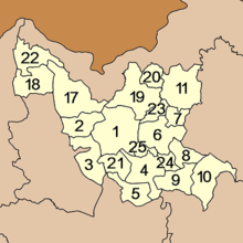 The province is subdivided into 20 districts (amphoe
). The districts are further subdivided into 155 subdistricts (tambon
) and 1682 villages (muban
). The missing numbers 12–16 were the geocode
s assigned to the districts which formed the province Nongbua Lamphu in 1993.
Nong Prachaksinlapakhom Public Park (สวนสาธารณะหนองประจักษ์ศิลปาคม) : On an island in the pond, a small garden is filled with decorative and flowering plants, and there is a bridge linking the island with the mainland. Within the park, there is a fountain, a clock tower, and a playground.
Wat Phothisomphon (วัดโพธิสมภรณ์) : It was built in the late reign of King Rama V. Inside, there is also a museum of revered monks famous for meditation.
Udon Thani Museum (พิพิธภัณฑ์เมืองอุดร) : It displays background aspects of Udon Thani, ranging from history, archaeology, natural science, geology, folk history, arts and culture, to the biography and honorable deeds of Krommaluang Prachaksinlapakhom, the founder of Udon Thani town.
Wat Matchimawat (วัดมัชฌิมาวาส) : Within its Wihan building, there is a white stone Buddha image under Naga (serpent) protection, or commonly known as “Luangpho Nak,” which has been highly respected by the people of Udon Thani.
Chaopu – Chaoya Chinese Spirit Shrine (ศาลเจ้าปู่-ย่า) : This large and beautiful Chinese spirit shrine is located near Nong Bua Market. Two Chinese pavilions stand in the pond, serving as a view point in pleasant and shady surroundings. The golden dragon of 99 m long, to be used during the Thung Si Mueang annual fair in December, is also kept here.
Udorn Sunshine Orchid Farm (สวนกล้วยไม้หอมอุดรซันไฌน์) : It is a nursery of Udorn Sunshine, a new fragrant Thai orchid species from cross-breeding Vanda with Josephine Van Berrow. The flower was registered as “Udorn Sunshine Orchid” or “Miss Udorn Sunshine” for a copyright with the World Orchid Society in the United Kingdom in 1988.
Wat Pa Ban Tat (วัดป่าบ้านตาด) : Inside its compound, wild animals are in abundance: pheasant, red jungle fowl, birds, squirrel, tree shrew, common wild pig etc. The temple is also a residence of Phra Achan Maha Bua Yannasampanno, the revered Buddhist master of meditation and a follower of Phra Achan Man Phurithatto, the late master.
Wat Thipphayaratnimit (วัดทิพยรัฐนิมิตร) : It is another forest temple in the area of Amphoe Mueang and has a pleasant shady atmosphere. There is a large pagoda which contains Lord Buddha’s relics. The pagoda is shaped like “Thanan,” a utensil used in ancient times to scoop Lord Buddha’s relics.
Ban Na Kha (บ้านนาข่า) : Located 16 km from town along the Udon Thani – Nong Khai route (Highway No. 2), opposite the Na Kha Community School.
Huai Luang Reservoir (อ่างเก็บน้ำห้วยหลวง) : It is a large reservoir covering an area of about 20,000 rai, for the purposes of agriculture, fishery, and waterworks under the responsibility of the Royal Irrigation Department, Ministry of Agriculture and Co-operatives.
Phu Phra Bat Historical Park (อุทยานประวัติศาสตร์ภูพระบาท) : It displays the civilisation of mankind and changes in landscape of which structure is mostly composed of sandstone having been eroded by nature to become rock formations of different sizes and patterns. There are various interesting places as evidence of human life in the past:
Phra Phutthabat Bua Bok
: This Buddha’s footprint, built during 1920–1934. The plant was abundant in the area where the Buddha’s footprint was found, so it has become the name of the place, or the name may originate from the words “Bo Bok,” which mean “not being dry.”
Phra Phutthabat Lang Tao : This Buddha’s footprint is around 25 cm deep in the rocky ground and has a lotus image carved in relief in the centre. Since it is behind a stone shelter that looks like a turtle (Tao), the footprint is called “Phra Phuttabat Lang Tao.”
Caves and Stone Shelters : These caves were presumed to be a shelter of people in the Stone Age, and they drew figures of things, such as humans, hand, animals, and geometric designs, found in the caves. Stone shelters beautifully created by nature include Khok Ma Thao Barot, Ho Nang Usa, and Bo Nam Nang Usa.
Phra Phutthabat Bua Ban (พระพุทธบาทบัวบาน) : This is a site where there is an ancient Buddha’s footprint housed in the Ubosot (ordination hall). Many pieces of Bai Sema
(boundary stone) were excavated here.
Wat Pa Ban Kho (วัดป่าบ้านค้อ) : Here, there is Phra Maha That Chedi Chaloem Barami Phra Nawamin, a pagoda that contains Lord Buddha’s relics. The temple is ideal for practitioners of Dharma (Buddha’s teachings).
Na Yung – Nam Som National Park (อุทยานแห่งชาตินายูงน้ำโสม) : This national park is located in Ban Sawang, Mu 2, Tambon Na Yung. Attractions of the park are:
Ban Chiang National Museum (พิพิธภัณฑสถานแห่งชาติ บ้านเชียง) : It is an important historical site of Northeast Thailand and Southeast Asia. The United Nations Educational, Scientific and Cultural Organization (UNESCO) registered the site as a World Heritage Site of history at Carthage. The museum is divided into three parts:
Kham Chanot (คำชะโนด) : This sacred place gains respect from villagers in neighbouring areas. It is said to be an entrance to the water world, a legendary place concerning the great Naga (serpent). Inside, there is a shrine of Chaopu Sisuttho and a sacred well for worship.
Phrathat Don Kaeo or Phra Maha That Chedi (พระธาตุดอนแก้ว หรือพระมหาธาตุเจดีย์) : It is an angular pagoda resembling Phrathat Phanom, with a height of over 18 wa. The main body was built into 2 tiers: each has sculptures of Lord Buddha’s history and heaven – hell story.
Namtok Than Ngam Forest Park (วนอุทยานน้ำตกธารงาม) : Around Than Ngam Waterfall is Mixed Deciduous Forest; major species are Ta baek, Pradu, Daeng, Makha mong, Chingchan, and Krabok. The waterfall contains water at certain times; there is a lot of water during the rainy season.
Phu Foi Lom (ภูฝอยลม) : This ecotourism site is located in Pa Phan Don – Pakho National Forest Reserve. It is considered as one of the best nature study centres of the Northeast region.
Wang Sam Mo Forest Park (วนอุทยานวังสามหมอ) : Most of the area is a plain being covered with Pa Daeng or Deciduous Dipterocarp Forest, Yang, and Ta khian thong. There are creeks and islets where water flows all year round. Wild animals found are Malayan flying lemur, palm civet, civet, green pigeon, etc. Interesting places include:
-pattern cloth, silk cloth, pottery, Kun Chiang (Chinese sausage), Mu Yong (pork floss), Mu Yo (steamed pork bar), Naem (sour pork) and Maphrao Kaeo (coconut sweet).
Thung Si Mueang Udon Thani and Mi-khit Cloth Fair (งานทุ่งศรีเมืองอุดรธานีผ้าหมี่ขิต) : This annual fair is held around December. There are booths of goods and local products, such as silk cloth, Khit-pattern woven cloth, hand – woven cloth, Mi-Khit cloth, and a golden dragon show from the Chaopu – Chaoya Chinese Spirit Shrine.
Isan
Isan is the northeastern region of Thailand. It is located on the Khorat Plateau, bordered by the Mekong River to the north and east, by Cambodia to the southeast and the Prachinburi mountains south of Nakhon Ratchasima...
provinces
Provinces of Thailand
Thailand is divided into 76 provinces , which are geographically grouped into 6 regions. The capital Bangkok is not a province but a special administrative area and is included as the 77th province since it is administered at the same level as the other 76 provinces. The name of the provinces are...
(changwat) of Thailand
Thailand
Thailand , officially the Kingdom of Thailand , formerly known as Siam , is a country located at the centre of the Indochina peninsula and Southeast Asia. It is bordered to the north by Burma and Laos, to the east by Laos and Cambodia, to the south by the Gulf of Thailand and Malaysia, and to the...
. Neighboring provinces are (from north clockwise) Nong Khai
Nong Khai Province
Nong Khai is the northernmost of the north-eastern provinces of Thailand. Neighboring provinces are Bueng Kan, Sakon Nakhon, Udon Thani and Loei...
, Sakon Nakhon
Sakon Nakhon Province
Sakon Nakhon is one of the north-eastern provinces of Thailand. Neighboring provinces are Nong Khai, Nakhon Phanom, Mukdahan, Kalasin and Udon Thani...
, Kalasin
Kalasin Province
Kalasin is one of the provinces of Thailand, located in the North-East of Thailand. Neighboring provinces are Sakon Nakhon, Mukdahan, Roi Et, Maha Sarakham, Khon Kaen and Udon Thani.-Geography:...
, Khon Kaen
Khon Kaen Province
-History:The first city of the area was established in 1783 when Rajakruluang settled there with 330 people. King Rama I made Rajakruluang the first governor of the area when establishing tighter connections with the Isan area. The main city was moved six times until in 1879 it reached its modern...
, Nong Bua Lamphu
Nongbua Lamphu Province
Nong Bua Lam Phu is one of the north-eastern provinces of Thailand. Neighboring provinces are Udon Thani, Khon Kaen and Loei.-History:...
and Loei
Loei Province
Loei is one of the most sparsely populated provinces of Thailand, located in the North-East. Neighboring provinces are Nong Khai, Udon Thani, Nongbua Lamphu, Khon Kaen, Phetchabun, Phitsanulok...
.
Geography
Udon Thani Province is located in the north of the Khorat PlateauKhorat Plateau
The Khorat Plateau also Korat Plateau, is a plateau in the northeastern region of Thailand, named for the short form of Nakhon Ratchasima, an historical stronghold controlling access to and from the plateau.-Geography:...
, between the provinces of Khon Kaen
Khon Kaen Province
-History:The first city of the area was established in 1783 when Rajakruluang settled there with 330 people. King Rama I made Rajakruluang the first governor of the area when establishing tighter connections with the Isan area. The main city was moved six times until in 1879 it reached its modern...
to its south, and Nong Khai
Nong Khai Province
Nong Khai is the northernmost of the north-eastern provinces of Thailand. Neighboring provinces are Bueng Kan, Sakon Nakhon, Udon Thani and Loei...
to its north. The city of Udon Thani
Udon Thani
Udon Thani is a city in Isan, north-east Thailand, and the capital of Udon Thani Province.-Location:The province of Udon Thani has a population of 1,467.200, the city alone 500.000. Geographical location and is approximately 560 km from Bangkok...
, its capital, is served by the railway line that goes northeast from Saraburi through Nakhon Ratchasima
Nakhon Ratchasima
Nakhon Ratchasima or is a city in the north-east of Thailand and gateway to Isan. It is the capital of the Nakhon Ratchasima Province and Nakhon Ratchasima district...
(Khorat
Khorat
Khorat can refer to*the informal name of Nakhon Ratchasima town or Nakhon Ratchasima Province*the Khorat Sub-district in Sung Noen District of Nakhon Ratchasima Province...
) and Khon Kaen to the border of Laos
Laos
Laos Lao: ສາທາລະນະລັດ ປະຊາທິປະໄຕ ປະຊາຊົນລາວ Sathalanalat Paxathipatai Paxaxon Lao, officially the Lao People's Democratic Republic, is a landlocked country in Southeast Asia, bordered by Burma and China to the northwest, Vietnam to the east, Cambodia to the south and Thailand to the west...
on the outskirts of Nong Khai city. Regular direct trains including night sleepers connect the city with Bangkok. The provincial capital, often referred to as just Udon
Udon Thani
Udon Thani is a city in Isan, north-east Thailand, and the capital of Udon Thani Province.-Location:The province of Udon Thani has a population of 1,467.200, the city alone 500.000. Geographical location and is approximately 560 km from Bangkok...
, is Thailand
Thailand
Thailand , officially the Kingdom of Thailand , formerly known as Siam , is a country located at the centre of the Indochina peninsula and Southeast Asia. It is bordered to the north by Burma and Laos, to the east by Laos and Cambodia, to the south by the Gulf of Thailand and Malaysia, and to the...
's fifth-largest MSA
MSA
-Organisations and businesses:*Malaysia-Singapore Airlines, the former name for Singapore Airlines and Malaysia Airlines*Maritime Safety Administration, one of two PRC Coast Guards. The other being the China Coast Guard...
. In Roman script it is also often spelled Udorn.
Climate
Transport
AirStrategically important for the Isan
Isan
Isan is the northeastern region of Thailand. It is located on the Khorat Plateau, bordered by the Mekong River to the north and east, by Cambodia to the southeast and the Prachinburi mountains south of Nakhon Ratchasima...
region's infrastructure, Udon Thani's airport
Udon Thani International Airport
Udonthani International Airport is an airport located near the city of Udon Thani in Udon Thani Province in the northeast region of Thailand. It is approximately 280 miles northeast of Bangkok...
was raised to international standard in 2006 with the opening of a new terminal to compliment its existing domestic arrival and departure building which is now defunct. At peak times of the year there may be as many as 20 scheduled flights per day operating in and out of Udon Thani, thus making it one of the country's busiest domestic airports. Currently, two budget airlines, Air Asia and Nok Air
Nok Air
Nok Air , the Thai word for bird) is a low-cost airline headquartered in Sathorn, Bangkok, Thailand, operating domestic and international services out of Bangkok Don Mueang Airport. Nok Air is the budget airline of Thai Airways International...
, and the national carrier, Thai Airways
Thai Airways International
Thai Airways International Public Company Limited is the national flag carrier and largest airline of Thailand. Formed in 1988, the airline's headquarters are located in Chatuchak District, Bangkok, and operates out of Suvarnabhumi Airport. Thai is a founding member of the Star Alliance. Thai is a...
, operate from the airport.
Road
The city is bisected by Mittraphap Road, the highway linking Bangkok with the Northeast and Laos. A modern, multi-lane ringroad system enables through traffic to bypass the city centre either to the west or the east. It connects to the airport and to the main roads leading to Nong Bua Lamphu province in the west and to Sakhon Nakhon in the east.
Rail
A station in the city centre on the main Bangkok - Nong Khai line provides the city with regular services to and from the capital and Nong Khai.
Bus
Essential local and city services are provided by songthew truck and pickup truck busses, while regional and long distance destinations are served by regular bus vehicles from several bus terminals. The long distance 'VIP' First Class busses operate from a terminal in the city centre and connect Udon Thani with daytime and overnight routes to Bangkok and many province capitals.
History
Udon Thani first marked its name in the Bangkok era's history when Anuwong staged an uprising and marched the Laotians' troops to Nakhon Ratchasrima during 1826 to 1828. Met with fierce resistance from the local troops led by Lady Mo, wife to Nakhon Ratchasrima Governor, Anuwong was forced to move the troops back to Nongbua Lampoo, the city close to the present-day Udon Thani, and the Laotians eventually lost to Siam’s troops and the local Nongbua Lampoo’s militia.Formerly known as Ban Mak-kaeng, Udon Thani was first settled as a military base led by Prince Prachak to crack down on minority uprising in then north eastern state of Lao Puan. Ban Mak-kaeng has evolved from a rural city eventually into what is known as the present-day Udon Thani, literally the northern city.
The province is most famous for the archeological site Ban Chiang
Ban Chiang
Ban Chiang is an archeological site located in Nong Han district, Udon Thani Province, Thailand. It has been on the UNESCO world heritage list since 1992....
with its remains of the Bronze age
Bronze Age
The Bronze Age is a period characterized by the use of copper and its alloy bronze as the chief hard materials in the manufacture of some implements and weapons. Chronologically, it stands between the Stone Age and Iron Age...
, located in what is now a hamlet about 85 miles east of Udon. Udon is one of the more bustling markets for agricultural goods in the relatively dry northeast of Thailand, and received its biggest economic boost in the 1960s when the US built the Udon Royal Thai Air Force Base
Udon Thani International Airport
Udonthani International Airport is an airport located near the city of Udon Thani in Udon Thani Province in the northeast region of Thailand. It is approximately 280 miles northeast of Bangkok...
as a joint-force military base during the Vietnam War
Vietnam War
The Vietnam War was a Cold War-era military conflict that occurred in Vietnam, Laos, and Cambodia from 1 November 1955 to the fall of Saigon on 30 April 1975. This war followed the First Indochina War and was fought between North Vietnam, supported by its communist allies, and the government of...
. (the Mel Gibson film Air America refers to Udon and includes shots from the Udon military base.) Udon Thani was also the largest base in the region for CIA's anti-communism
Anti-communism
Anti-communism is opposition to communism. Organized anti-communism developed in reaction to the rise of communism, especially after the 1917 October Revolution in Russia and the beginning of the Cold War in 1947.-Objections to communist theory:...
campaign.
The U.S. turned the base over to the Thai military in 1976, but there were three significant after-effects of the base's US presence. First, a number of the natives in the area were paid well and learned English, which helped them become more marketable to the outside world (a significant percentage of the more educated group now work in the Middle East oilfields). Second, the base created ties, including a US Consulate in Udon, which was closed in 1995, and a US Veterans of Foreign Wars
Veterans of Foreign Wars
The Veterans of Foreign Wars of the United States is a congressionally chartered war veterans organization in the United States. Headquartered in Kansas City, Missouri, VFW currently has 1.5 million members belonging to 7,644 posts, and is the largest American organization of combat...
Post. Finally, the base and the consulate caused the city to be viewed as a regional hub, and this impression has continued.
In recent years the province has received international attention due to the discovery of a large potash
Potash
Potash is the common name for various mined and manufactured salts that contain potassium in water-soluble form. In some rare cases, potash can be formed with traces of organic materials such as plant remains, and this was the major historical source for it before the industrial era...
deposit in the area and some anticipate that the region will become a major exporter of the mineral. Beginning the mining
Mining
Mining is the extraction of valuable minerals or other geological materials from the earth, from an ore body, vein or seam. The term also includes the removal of soil. Materials recovered by mining include base metals, precious metals, iron, uranium, coal, diamonds, limestone, oil shale, rock...
process of gaining licensure has been substantially delayed due to public opposition to the mine. Many of the villagers who live directly above the proposed mine site have expressed concern that the company and its Environmental Impact Assessment
Environmental impact assessment
An environmental impact assessment is an assessment of the possible positive or negative impact that a proposed project may have on the environment, together consisting of the natural, social and economic aspects....
(EIA) have not adequately addressed concerns of salinization of groundwater and soil or land subsidence. Both would threaten the economic stability of local communities that rely primarily on income derived from rice farming.
Symbols
The provincial seal shows a Hindu mythological giant (yakṣaYaksha
Yaksha is the name of a broad class of nature-spirits, usually benevolent, who are caretakers of the natural treasures hidden in the earth and tree roots. They appear in Hindu, Jain and Buddhist mythology. The feminine form of the word is ' or Yakshini .In Hindu, Jain, and Buddhist mythology,...
in Thai yak), referring to Thao Kuwane (Vaiśravaṇa
Vaisravana
' or ' also known as Jambhala in Tibet and Bishamonten in Japan is the name of the chief of the Four Heavenly Kings and an important figure in Buddhist mythology.-Names:...
or Kubera
Kubera
Kubera , also spelt Kuber, is the Lord of wealth and the god-king of the semi-divine Yakshas in Hindu mythology. He is regarded as the regent of the North , and a protector of the world His many epithets extol him as the overlord of numerous semi-divine species and the owner of the treasures of...
), the god of the North.
The provincial tree is the Teng (Shorea obtusa
Shorea
Shorea is a genus of about 196 species of mainly rainforest trees in the family Dipterocarpaceae. The genus is named after Sir John Shore, the Governor-General of the British East India Company, 1793-1798. They are native to southeast Asia, from Northern India to Malaysia, Indonesia and the...
), and the provincial flower is the Flame of the forest (Butea monosperma
Butea monosperma
Butea monosperma is a species of Butea native to tropical and sub-tropical parts of the Indian Subcontinent and Southeast Asia, ranging across India, Bangladesh, Nepal, Pakistan, Sri Lanka, Myanmar, Thailand, Laos, Cambodia, Vietnam, Malaysia, and western Indonesia...
).
Administrative divisions
Amphoe
An amphoe is the second level administrative subdivision of Thailand. Usually translated as district, amphoe make up the provinces, and are analogous to a county seat...
). The districts are further subdivided into 155 subdistricts (tambon
Tambon
Tambon is a local government unit in Thailand. Below district and province , they form the third administrative subdivision level. As of the 2009 there are 7255 tambon, not including the 169 khwaeng of Bangkok, which are set at the same administrative level, thus every district contains 8-10 tambon...
) and 1682 villages (muban
Muban
Muban is the lowest administrative subdivision of Thailand. Usually translated as village, they are the subdivision of tambon. As of 2008, there are 74944 administrative villages in Thailand. As of the 1990 census, the average village consisted of 144 households or 746 persons.A muban does not...
). The missing numbers 12–16 were the geocode
Geocode
GEOCODE is a standardized all-natural number representation format specification for geospatial coordinate measurements that provide details of the exact location of geospatial point at, below, or above the surface of the earth at a specified moment of time.Geocode is patented under US Patents...
s assigned to the districts which formed the province Nongbua Lamphu in 1993.
|
|
Sights
The Monument of Krommaluang Prachaksinlapakhom (อนุสาวรีย์พระเจ้าบรมวงศ์เธอ กรมหลวงประจักษ์ศิลปาคม) : As the founder of Udon town in 1893, Major General Prince Prachaksinlapakhom set out the civil administration order and served important official duties for the public benefits. The Monument symbolizes the highest tribute paid to the prince by the people of Udon Thani.Nong Prachaksinlapakhom Public Park (สวนสาธารณะหนองประจักษ์ศิลปาคม) : On an island in the pond, a small garden is filled with decorative and flowering plants, and there is a bridge linking the island with the mainland. Within the park, there is a fountain, a clock tower, and a playground.
Wat Phothisomphon (วัดโพธิสมภรณ์) : It was built in the late reign of King Rama V. Inside, there is also a museum of revered monks famous for meditation.
Udon Thani Museum (พิพิธภัณฑ์เมืองอุดร) : It displays background aspects of Udon Thani, ranging from history, archaeology, natural science, geology, folk history, arts and culture, to the biography and honorable deeds of Krommaluang Prachaksinlapakhom, the founder of Udon Thani town.
Wat Matchimawat (วัดมัชฌิมาวาส) : Within its Wihan building, there is a white stone Buddha image under Naga (serpent) protection, or commonly known as “Luangpho Nak,” which has been highly respected by the people of Udon Thani.
Chaopu – Chaoya Chinese Spirit Shrine (ศาลเจ้าปู่-ย่า) : This large and beautiful Chinese spirit shrine is located near Nong Bua Market. Two Chinese pavilions stand in the pond, serving as a view point in pleasant and shady surroundings. The golden dragon of 99 m long, to be used during the Thung Si Mueang annual fair in December, is also kept here.
Udorn Sunshine Orchid Farm (สวนกล้วยไม้หอมอุดรซันไฌน์) : It is a nursery of Udorn Sunshine, a new fragrant Thai orchid species from cross-breeding Vanda with Josephine Van Berrow. The flower was registered as “Udorn Sunshine Orchid” or “Miss Udorn Sunshine” for a copyright with the World Orchid Society in the United Kingdom in 1988.
Wat Pa Ban Tat (วัดป่าบ้านตาด) : Inside its compound, wild animals are in abundance: pheasant, red jungle fowl, birds, squirrel, tree shrew, common wild pig etc. The temple is also a residence of Phra Achan Maha Bua Yannasampanno, the revered Buddhist master of meditation and a follower of Phra Achan Man Phurithatto, the late master.
Wat Thipphayaratnimit (วัดทิพยรัฐนิมิตร) : It is another forest temple in the area of Amphoe Mueang and has a pleasant shady atmosphere. There is a large pagoda which contains Lord Buddha’s relics. The pagoda is shaped like “Thanan,” a utensil used in ancient times to scoop Lord Buddha’s relics.
Ban Na Kha (บ้านนาข่า) : Located 16 km from town along the Udon Thani – Nong Khai route (Highway No. 2), opposite the Na Kha Community School.
Huai Luang Reservoir (อ่างเก็บน้ำห้วยหลวง) : It is a large reservoir covering an area of about 20,000 rai, for the purposes of agriculture, fishery, and waterworks under the responsibility of the Royal Irrigation Department, Ministry of Agriculture and Co-operatives.
Phu Phra Bat Historical Park (อุทยานประวัติศาสตร์ภูพระบาท) : It displays the civilisation of mankind and changes in landscape of which structure is mostly composed of sandstone having been eroded by nature to become rock formations of different sizes and patterns. There are various interesting places as evidence of human life in the past:
Phra Phutthabat Bua Bok
Phu Phra Bat Buabok Forest Park
Phu Phra Bat Buabok is a forest park in Ban Phue district, Udon Thani Province, northeast Thailand.Named after two Buddha footprints carved into rocks in the Lan Xang style, the park is located at a disconnected sandstone hill at the eastern edge of the Phu Phan mountains...
: This Buddha’s footprint, built during 1920–1934. The plant was abundant in the area where the Buddha’s footprint was found, so it has become the name of the place, or the name may originate from the words “Bo Bok,” which mean “not being dry.”
Phra Phutthabat Lang Tao : This Buddha’s footprint is around 25 cm deep in the rocky ground and has a lotus image carved in relief in the centre. Since it is behind a stone shelter that looks like a turtle (Tao), the footprint is called “Phra Phuttabat Lang Tao.”
Caves and Stone Shelters : These caves were presumed to be a shelter of people in the Stone Age, and they drew figures of things, such as humans, hand, animals, and geometric designs, found in the caves. Stone shelters beautifully created by nature include Khok Ma Thao Barot, Ho Nang Usa, and Bo Nam Nang Usa.
Phra Phutthabat Bua Ban (พระพุทธบาทบัวบาน) : This is a site where there is an ancient Buddha’s footprint housed in the Ubosot (ordination hall). Many pieces of Bai Sema
Bai Sema
Bai Sema are the boundary stones which designate the sacred area for a phra ubosot within a Thai Buddhist temple .-History:...
(boundary stone) were excavated here.
Wat Pa Ban Kho (วัดป่าบ้านค้อ) : Here, there is Phra Maha That Chedi Chaloem Barami Phra Nawamin, a pagoda that contains Lord Buddha’s relics. The temple is ideal for practitioners of Dharma (Buddha’s teachings).
Na Yung – Nam Som National Park (อุทยานแห่งชาตินายูงน้ำโสม) : This national park is located in Ban Sawang, Mu 2, Tambon Na Yung. Attractions of the park are:
-
- Namtok Yung Thong(น้ำตกยูงทอง) : This waterfall is located on the ridge of Mount Phu Phan and Mount Phu Ya U, around 500 m from the park headquarters. Its stream flows along attractive complicated boulders amid the greenery of trees.
- Pha Daeng Viewpoint (จุดชมวิวผาแดง) : is a high steep sandstone cliff overlooking a beautiful panoramic view. Not far from Pha Daeng, there is a small cave where Luang Pu Man Phurithatto used to stay for insight development.
Ban Chiang National Museum (พิพิธภัณฑสถานแห่งชาติ บ้านเชียง) : It is an important historical site of Northeast Thailand and Southeast Asia. The United Nations Educational, Scientific and Cultural Organization (UNESCO) registered the site as a World Heritage Site of history at Carthage. The museum is divided into three parts:
-
- Wat Pho Si Nai Excavation Pit (หลุมขุดค้นวัดโพธิ์ศรีใน) : This features an open museum, the first of its kind in Thailand. There is a permanent exhibition of archaeological excavation to witness art objects in layers of soil; most of them are earthenware being buried with the corpses.
- Somdet Phra Srinagarindra Borommaratchachonnani Building (อาคารสมเด็จพระศรีนครินทราบรมราชชนนี) : This building displays an exhibition of Ban Chiang which was once brought to display in the United States and Singapore. The exhibition has two segments: Ban Chiang in the Past, and Today’s Ban Chiang.
- Ban Thai Phuan (บ้านไทพวน) : This area is an ancient site where archaeological excavation was conducted and many ancient objects were found.
Kham Chanot (คำชะโนด) : This sacred place gains respect from villagers in neighbouring areas. It is said to be an entrance to the water world, a legendary place concerning the great Naga (serpent). Inside, there is a shrine of Chaopu Sisuttho and a sacred well for worship.
Phrathat Don Kaeo or Phra Maha That Chedi (พระธาตุดอนแก้ว หรือพระมหาธาตุเจดีย์) : It is an angular pagoda resembling Phrathat Phanom, with a height of over 18 wa. The main body was built into 2 tiers: each has sculptures of Lord Buddha’s history and heaven – hell story.
Namtok Than Ngam Forest Park (วนอุทยานน้ำตกธารงาม) : Around Than Ngam Waterfall is Mixed Deciduous Forest; major species are Ta baek, Pradu, Daeng, Makha mong, Chingchan, and Krabok. The waterfall contains water at certain times; there is a lot of water during the rainy season.
Phu Foi Lom (ภูฝอยลม) : This ecotourism site is located in Pa Phan Don – Pakho National Forest Reserve. It is considered as one of the best nature study centres of the Northeast region.
Wang Sam Mo Forest Park (วนอุทยานวังสามหมอ) : Most of the area is a plain being covered with Pa Daeng or Deciduous Dipterocarp Forest, Yang, and Ta khian thong. There are creeks and islets where water flows all year round. Wild animals found are Malayan flying lemur, palm civet, civet, green pigeon, etc. Interesting places include:
-
- Wang Yai (วังใหญ่) : This large pond has water flowing all year round. Lam Phan Chat creek flows through the pond.
- Kaeng Mon Noi (แก่งมนน้อย) : These rapids are around 800 m away from Wang Yai pond. Cascades against boulders which were eroded by water form beautiful waterfalls at certain points along their course.
- Kaeng Hin Hom (แก่งหินฮอม) : These large split-level rapids are around 100 m from Kaeng Mon Noi. The resonant roar is heard in the distance during the rainy season when there is a lot of downpour.
- Tham Sing (ถ้ำสิงห์) : Attractions inside the cave are:
- Sam Ton Mak (ซำต้นหมาก) : This is an area where a lot of betel palm trees grow. During the rainy season, the area is always flooded. Villagers usually take their cattle to lap water here.
- Lan Thap Khwai (ลานทับควาย) : This is a broad ground with a roof-shaped rock formation and surrounding wild plants. Lan Thap Khwai literally means a cattle rest ground. In the old days, villagers brought their cattle to feed and took shelter here for a lunch break.
- Tham Khok Ma (ถ้ำคอกม้า) : This stable cave is a shelter of overlapping rock formations with a hole that a person can walk through. Its name relates to the legend of Usa-Barot.
- Tham Ruesi (ถ้ำฤาษี) : This hermit cave features a boulder of 2.20 m high with an entrance in the shape of a shelter of overlapping rock formations.
Local Products
KhitKhit
Khit, or Khid, is an ancient type of woven cloth produced in certain areas of Isaan, the northeastern region of Thailand.-Tradition:Khit weaving is done by hand in traditional looms. It favours certain basic colors, like red, purple and dark green, although other colors are also used...
-pattern cloth, silk cloth, pottery, Kun Chiang (Chinese sausage), Mu Yong (pork floss), Mu Yo (steamed pork bar), Naem (sour pork) and Maphrao Kaeo (coconut sweet).
Festivals
Phra Phutthabat Bua Bok Worship Fair (งานนมัสการพระพุทธบาทบัวบก) : This annual fair is held during the13th – 15th waxing moon days of the 3rd lunar month with booths of goods and local products for sale.Thung Si Mueang Udon Thani and Mi-khit Cloth Fair (งานทุ่งศรีเมืองอุดรธานีผ้าหมี่ขิต) : This annual fair is held around December. There are booths of goods and local products, such as silk cloth, Khit-pattern woven cloth, hand – woven cloth, Mi-Khit cloth, and a golden dragon show from the Chaopu – Chaoya Chinese Spirit Shrine.
External links
- Official website of the province
- Province page from the Tourist Authority of Thailand
- Potash Mining in Udon Thani Province