

Amphoe Ban Dung
Encyclopedia
Ban Dung is a district (Amphoe
) in the northeastern part of Udon Thani Province
, northeastern Thailand
.
, Phibun Rak
, Phen
and Sang Khom
of Udon Thani Province, Phon Phisai
and Fao Rai
of Nong Khai Province
, and Ban Muang
, Charoen Sin
and Sawang Daen Din
of Sakon Nakhon Province
.
To the North of Ban Dung Is a large expanse of Marsh and open water called Nong Pla Tao.
The major river is the Songkhram
, which marks the boundary of the district to the east.
The other seasons are the cool season from October to February, when the people sit outside around fires in the evenings, and the hot season from February to May with its sudden peak of high temperatures in April.
. It was upgraded to a full district on July 16 1963.
), which are further subdivided into 140 villages (muban
). Ban Dung is a town (thesaban mueang) which covers parts of the subdistrict Ban Dung and the whole subdistrict Si Suttho. The town is subdivided into 34 communities (chumchon). There are further 12 Tambon administrative organizations (TAO).
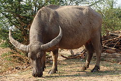 Water buffalo are a regular feature being walked to and from the fields at dawn and dusk. Although rarely used nowadays for working the land, they are considered an important status symbol.
Refined salt for domestic use is made by evaporating salt water in large open vats using ovens with Rice Husks used as the fuel source . This method produces very clean, fine grained salt in which the Impurities are removed during cooking. Traditionally, the stove used in salt making was wood-fueled. Latterly wood has became more expensive prompting a shift to rice hull stoves. The abundance of rice hulls has made it economically feasible to reprocess the salt and is a renewable source of fuel.
Approximately 10k from Ban dung Wat Kham Chanot
is said to be an entrance to the water world, a legendary place where the Naga, a mythical large snake often suggested to have seven heads is supposed to live . Covering an area of over 20 rai of land it is nothing but an islet surrounded by water teeming with dense palm trees called Chanot.
The Voice of America
headquarters for South East Asia is situated 2 miles out of Ban Dung on highway 2022. Many 500 kW shortwave transmitters are installed here. Call sign: Udon Thani
There are two main public buses both start at the central bus station in Udon Thani. One bus route goes via Highway 22 and then turns left at Nong Mek along highway 2096 to Bandung. The other Bus route goes via Highway two before turning right at Ban Na Kha along highway 2256 to the Sum Sao intersection and then along highway 2022 to Ban Dung. Both run at run at regular intervals.
Long distance 'VIP' First Class buses operate from opposite the Police Station and run nightly to Bangkok.
Amphoe
An amphoe is the second level administrative subdivision of Thailand. Usually translated as district, amphoe make up the provinces, and are analogous to a county seat...
) in the northeastern part of Udon Thani Province
Udon Thani Province
Udon Thani is one of the north-eastern provinces of Thailand. Neighboring provinces are Nong Khai, Sakon Nakhon, Kalasin, Khon Kaen, Nong Bua Lamphu and Loei.- Geography :...
, northeastern Thailand
Thailand
Thailand , officially the Kingdom of Thailand , formerly known as Siam , is a country located at the centre of the Indochina peninsula and Southeast Asia. It is bordered to the north by Burma and Laos, to the east by Laos and Cambodia, to the south by the Gulf of Thailand and Malaysia, and to the...
.
Geography
Neighboring districts are (from the south clockwise) Thung FonAmphoe Thung Fon
Thung Fon is a district in the eastern part of Udon Thani Province, northeastern Thailand.-Geography:Neighboring districts are Nong Han, Phibun Rak, Ban Dung of Udon Thani Province, Phon Phisai and Sawang Daen Din of Sakon Nakhon Province.-History:The minor district Thung Fon was created on...
, Phibun Rak
Amphoe Phibun Rak
Phibun Rak is a district in the central part of Udon Thani Province, northeastern Thailand.-Geography:Neighboring districts are Nong Han, Chai Wan, Si That, Kumphawapi and Prachaksinlapakhom.-History:...
, Phen
Amphoe Phen
Phen is a district in the northern part of Udon Thani Province, northeastern Thailand.- Geography :Neighboring districts are Sang Khom, Ban Dung, Phibun Rak, Mueang Udon Thani, Ban Phue of Udon Thani Province, Sakhrai, Mueang Nong Khai and Phon Phisai of Nong Khai Province.- History :The...
and Sang Khom
Amphoe Sang Khom
Sang Khom is a district in the northern part of Udon Thani Province, northeastern Thailand.-Geography:Neighboring districts are Ban Dung, Phen and Phon Phisai of Nong Khai Province.-History:...
of Udon Thani Province, Phon Phisai
Amphoe Phon Phisai
Phon Phisai is a district of Nong Khai Province, northeastern Thailand.-History:The district was originally part of Mueang Phon Phaeng, now part of Rattanawapi district...
and Fao Rai
Amphoe Fao Rai
Fao Rai is a district of Nong Khai Province, northeastern Thailand.-Geography:Neighboring districts are Phon Phisai and Rattanawapi of Nong Khai Province, So Phisai of Bueng Kan Province, Ban Muang of Sakon Nakhon Province, and Ban Dung of Udon Thani Province.-History:The minor district was...
of Nong Khai Province
Nong Khai Province
Nong Khai is the northernmost of the north-eastern provinces of Thailand. Neighboring provinces are Bueng Kan, Sakon Nakhon, Udon Thani and Loei...
, and Ban Muang
Amphoe Ban Muang
Ban Muang is a district of Sakon Nakhon Province, northeast Thailand.-Geography:Neighboring districts are Ban Dung of Udon Thani Province, Fao Rai of Nong Khai Province, So Phisai and Phon Charoen of Bueng Kan Province, Kham Ta Kla, Wanon Niwat and Charoen Sin of Sakon Nakhon Province.The...
, Charoen Sin
Amphoe Charoen Sin
Charoen Sin is a district of Sakon Nakhon Province, northeast Thailand.-Geography:Neighboring districts are Ban Muang, Wanon Niwat and Sawang Daen Din of Sakon Nakhon Province, and Ban Dung of Udon Thani Province....
and Sawang Daen Din
Amphoe Sawang Daen Din
Sawang Daen Din is a district in the western part of Sakon Nakhon Province, northeast Thailand.-Geography:Neighboring districts are Charoen Sin, Wanon Niwat, Phang Khon, Waritchaphum, Song Dao of Sakon Nakhon Province, Chai Wan, Nong Han, Thung Fon and Ban Dung of Udon Thani...
of Sakon Nakhon Province
Sakon Nakhon Province
Sakon Nakhon is one of the north-eastern provinces of Thailand. Neighboring provinces are Nong Khai, Nakhon Phanom, Mukdahan, Kalasin and Udon Thani...
.
To the North of Ban Dung Is a large expanse of Marsh and open water called Nong Pla Tao.
The major river is the Songkhram
Songkhram River
The Songkhram River is the one of tributaries of the Mekong River. It originates in the hills between Nong Han district, Udon Thani Province and Sawang Daen Din district, Sakon Nakhon Province...
, which marks the boundary of the district to the east.
Climate
Rainfall is unpredictable, but is concentrated in the rainy season from May to October. The rainy season begins with occasional short but heavy showers, eventually raining very heavily for longer periods almost every day, usually in the late afternoon or at night, until it ends abruptly at the onset of the cool season.The other seasons are the cool season from October to February, when the people sit outside around fires in the evenings, and the hot season from February to May with its sudden peak of high temperatures in April.
History
The minor district (King Amphoe) Ban Dung was established on May 16 1959, when three subdistricts were split off from Nong Han districtAmphoe Nong Han
Nong Han is a district of Udon Thani Province, northeastern Thailand.-Geography:Neighboring districts are Chai Wan, Ku Kaeo, Prachaksinlapakhom, Mueang Udon Thani, Phibun Rak and Thung Fon of Udon Thani Province, and Sawang Daen Din of Sakon Nakhon Province.-History:The archaeological site of...
. It was upgraded to a full district on July 16 1963.
Provincial Government
The district is subdivided into 13 subdistricts (tambonTambon
Tambon is a local government unit in Thailand. Below district and province , they form the third administrative subdivision level. As of the 2009 there are 7255 tambon, not including the 169 khwaeng of Bangkok, which are set at the same administrative level, thus every district contains 8-10 tambon...
), which are further subdivided into 140 villages (muban
Muban
Muban is the lowest administrative subdivision of Thailand. Usually translated as village, they are the subdivision of tambon. As of 2008, there are 74944 administrative villages in Thailand. As of the 1990 census, the average village consisted of 144 households or 746 persons.A muban does not...
). Ban Dung is a town (thesaban mueang) which covers parts of the subdistrict Ban Dung and the whole subdistrict Si Suttho. The town is subdivided into 34 communities (chumchon). There are further 12 Tambon administrative organizations (TAO).
| No. | Name | Thai | Villages | Inh. Population A population is all the organisms that both belong to the same group or species and live in the same geographical area. The area that is used to define a sexual population is such that inter-breeding is possible between any pair within the area and more probable than cross-breeding with individuals... |
|---|---|---|---|---|
| 1. | Si Suttho | ศรีสุทโธ | 12 | 14,708 |
| 2. | Ban Dung | บ้านดุง | 18 | 13,414 |
| 3. | Dong Yen | ดงเย็น | 8 | 6,558 |
| 4. | Phon Sung | โพนสูง | 17 | 10,937 |
| 5. | Om Ko | อ้อมกอ | 10 | 8,424 |
| 6. | Ban Chan | บ้านจันทน์ | 18 | 14,159 |
| 7. | Ban Chai | บ้านชัย | 9 | 8,426 |
| 8. | Na Mai | นาไหม | 13 | 10,066 |
| 9. | Thon Na Lap | ถ่อนนาลับ | 8 | 5,208 |
| 10. | Wang Thong | วังทอง | 9 | 6,212 |
| 11. | Ban Muang | บ้านม่วง | 14 | 8,494 |
| 12. | Ban Tat | บ้านตาด | 10 | 6,930 |
| 13. | Na Kham | นาคำ | 13 | 9,691 |
Central Government Agencies
- Crown Prince Hospital Ban Dung
- Ban Dung Police
- Dong Yen Police
- Forest Protection Unit
- Ban Dung District Revenue
- Ban Dung Arboretum
Local Government
- Municipal Administration Ban Dung
- Administration Organization Ban Dung
- Administrative Organization Dong Yen
- Administrative Organization Phon Sung
- Administrative Organization Om Ko
- Administrative Organization Ban Chan
- Administration Organization Ban Chai
- Administrative Organization Na Kham
- Administration Organization Na Thon Lab
- Administration Organization Wang Thong
- Administration Organization Ban Muang
- Administrative Organizations Ban Tat
- Administrative Organizations Na Kham
State enterprises and organizations
- Electricity Authority
- Water Supply Authority
- Bank for Agriculture and Agricultural Co-operatives
- Government Savings Bank
Local Education
- 5 Secondary schools
- 71 Elementary School
- 6 private schools
- 1 Technical School
Culture
The culture has much in common with that of the neighboring country of Laos. This affinity is shown in the cuisine, dress and temple architecture.Food
The food is distinct from Thai and Lao cuisines, but has elements in common with each. The most obvious characteristics are the use of sticky rice that accompanies almost every meal rather than plain rice, as well as fiery chiles. Popular dishes include papaya salad and grilled chicken.Religion
As in the rest of Thailand, the population is almost exclusively Theravada Buddhist, although this is combined with elements of animism and in rural areas there are pockets of Christianity. Overall within the district 91.13 per cent are Buddhist with Catholics representing 8.87 per cent. There are Christian churches in the Villages of Phon Sung where the majority of the population is catholic , Si Wattana and Si Sut Tho.Media
In common with may other districts Ban Dung has its own local Radio Station which broadcasts on FM 103MHz. All the broadcasts are in Thai.Economy
The average income per year in Ban Dung was 50,173 baht per person per year in 2009 with the majority of people being farmers . The major crop grown is rice with 271,213 rai being cultivated by 13,708 people out of a total farming area of 322,991 rai . There was also 20,462 rai of rubber under cultivation. Other crops included maize, cassava, eucalyptus, sugar cane and various fruit and vegetables. Other farming activities included the rearing of Buffalo, Cattle, Pigs and chickens with a small number of people raising fish in lakes or ponds.Salt production
The salt making area around Ban Dung has produced salts for industrial purposes for more than 25 years . The production method used as in many other places in N.E. Thailand is called solution mining. The mining is done by local co-operative groups.Refined salt for domestic use is made by evaporating salt water in large open vats using ovens with Rice Husks used as the fuel source . This method produces very clean, fine grained salt in which the Impurities are removed during cooking. Traditionally, the stove used in salt making was wood-fueled. Latterly wood has became more expensive prompting a shift to rice hull stoves. The abundance of rice hulls has made it economically feasible to reprocess the salt and is a renewable source of fuel.
Places of Interest
- Wat Kham Chanot
Approximately 10k from Ban dung Wat Kham Chanot
Wat Kham Chanot
Wat Kham Chanot is a buddhist temple near Ban Kham Chanot, Amphoe Ban Dung, Udon Thani Province in Northeastern Thailand. It is located in the Wang Nakhin area at a lake where the Nāga, a mythical large snake, is supposed to be living....
is said to be an entrance to the water world, a legendary place where the Naga, a mythical large snake often suggested to have seven heads is supposed to live . Covering an area of over 20 rai of land it is nothing but an islet surrounded by water teeming with dense palm trees called Chanot.
- Voice of America
The Voice of America
Voice of America
Voice of America is the official external broadcast institution of the United States federal government. It is one of five civilian U.S. international broadcasters working under the umbrella of the Broadcasting Board of Governors . VOA provides a wide range of programming for broadcast on radio...
headquarters for South East Asia is situated 2 miles out of Ban Dung on highway 2022. Many 500 kW shortwave transmitters are installed here. Call sign: Udon Thani
Transportation
The town is situated adjacent to the intersection of highway 2022 with highway 2096.Buses
Essential local services are provided by songthew truck and pickup truck buses, while regional and long distance destinations are served by regular buses from Udon Thani.There are two main public buses both start at the central bus station in Udon Thani. One bus route goes via Highway 22 and then turns left at Nong Mek along highway 2096 to Bandung. The other Bus route goes via Highway two before turning right at Ban Na Kha along highway 2256 to the Sum Sao intersection and then along highway 2022 to Ban Dung. Both run at run at regular intervals.
Long distance 'VIP' First Class buses operate from opposite the Police Station and run nightly to Bangkok.