

Sakon Nakhon Province
Encyclopedia
Sakon Nakhon is one of the north-eastern
provinces
(changwat) of Thailand
. Neighboring provinces are (from north clockwise) Nong Khai
, Nakhon Phanom
, Mukdahan
, Kalasin
and Udon Thani
. The capital is Sakon Nakhon
.
word sakala (Devanagari
: सकल) meaning entire, whole, or total, and the word Nakhon from Sanskrit nagara (Devanagari
: नगर) meaning town
or city
. Hence the name of the province literally means "City of cities" . In the Khmer language
the province is called Sakor Nokor.
 The province is located on the Khorat Plateau
, not far from the river Mekong
. The Nong Han
lake - the biggest natural lake of North-East Thailand - near the city Sakon Nakhon is a popular resort of the local people. The Phu Phan Mountains
delimit the province to the south.
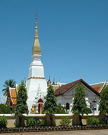
shows the Phrathat Choeng Chum, a Lao-style chedi
built during the Ayutthaya
period over a Khmer
style prang
.
The provincial tree is the banaba or Queen's Crape Myrtle (Lagerstroemia speciosa
).
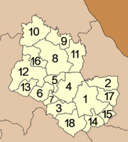 The province is subdivided into 18 districts (amphoe
). The districts are further subdivided into 125 communes (tambon
) and 1323 villages (muban
).
Ban Charn Arts and Crafts Centre (ศูนย์ศิลปาชีพบ้านจาร) - Located at Ban Charn, Tambon Mueng, Amphoe Ban Muang, the centre is production base and training hub for weaving silk and local textile, as well as blacksmith, wood carving.
Ban Pan Mor (บ้านปั้นหม้อ) - The pottery village Ban Chiang Krua is in Tambon Chiang Krua, Amphoe Muang, 15 km from Sakon Nakhon City via highway 22. The farmers here receive additional earnings through the pottery business.
Wha Yai and Ban Don Daeng Weaving Village (หมู่บ้านทอผ้าบ้านวาใหญ่ บ้านดอนแดง) - Located in Amphoe Arkat Amnuay, the villages are well known for woven cotton, silk and dye in “Khit
style” or local style. All textiles are dyed in natural dye
.
So Ram Luk Festival (งานเทศกาลโส้รำลึก) - The festival to commemorate the So ethnic group is held annually on the 4th waxing moon of March at Amphoe Kusumal. Traditional rites conducted by a number of So people will start in late morning.
Boon Mahachart Festival and Boon Bangfai or Rocket Festival, Amphoe Phang Kone (งานบุญมหาชาติและบุญบั้งไฟ อำเภอพังโคน) - The festivals are held annually in the first week of May. Its activities include the local rocket contest, Mahachart Preying, Phang Kone Cuisine Festival, and the contest of local rocket parade.
Wax castle procession (งานประเพณีแห่ปราสาทผึ้ง) - Held during the 12th-15th day of waxing moon in October to mark the end of Buddhist’s Lent, the festival is an exciting showcase. On the night of 13th day, people will join hands in decorating wax castle at Ming Muang Field. The 14th day, beautiful wax castle from different temples will join the procession, roaming the municipality to Wat Phra That Cherngchum Woravihara. Isan people believe that the wax will welcome Lord Buddha who comes back from the heaven to help all creatures on earth.
Boat race (งานประเพณีแข่งเรือ) - Held at the same time as the wax castle procession, the ancient boat race takes place at Phang Thong Pond or Tha Nang Arb, Ban Tha Wat.
Isan
Isan is the northeastern region of Thailand. It is located on the Khorat Plateau, bordered by the Mekong River to the north and east, by Cambodia to the southeast and the Prachinburi mountains south of Nakhon Ratchasima...
provinces
Provinces of Thailand
Thailand is divided into 76 provinces , which are geographically grouped into 6 regions. The capital Bangkok is not a province but a special administrative area and is included as the 77th province since it is administered at the same level as the other 76 provinces. The name of the provinces are...
(changwat) of Thailand
Thailand
Thailand , officially the Kingdom of Thailand , formerly known as Siam , is a country located at the centre of the Indochina peninsula and Southeast Asia. It is bordered to the north by Burma and Laos, to the east by Laos and Cambodia, to the south by the Gulf of Thailand and Malaysia, and to the...
. Neighboring provinces are (from north clockwise) Nong Khai
Nong Khai Province
Nong Khai is the northernmost of the north-eastern provinces of Thailand. Neighboring provinces are Bueng Kan, Sakon Nakhon, Udon Thani and Loei...
, Nakhon Phanom
Nakhon Phanom Province
Nakhon Phanom is one of the north-eastern provinces of Thailand. Neighboring provinces are Mukdahan, Sakon Nakhon and Bueng Kan. To the north-east it borders Khammouan of Laos.-Geography:...
, Mukdahan
Mukdahan Province
Mukdahan is one of the north-eastern provinces of Thailand. Neighboring provinces are Amnat Charoen, Yasothon, Roi Et, Kalasin, Sakon Nakhon and Nakhon Phanom. To the east it borders the Mekong River, across which lies Savannakhet Province of Laos.-Geography:The province is located in the...
, Kalasin
Kalasin Province
Kalasin is one of the provinces of Thailand, located in the North-East of Thailand. Neighboring provinces are Sakon Nakhon, Mukdahan, Roi Et, Maha Sarakham, Khon Kaen and Udon Thani.-Geography:...
and Udon Thani
Udon Thani Province
Udon Thani is one of the north-eastern provinces of Thailand. Neighboring provinces are Nong Khai, Sakon Nakhon, Kalasin, Khon Kaen, Nong Bua Lamphu and Loei.- Geography :...
. The capital is Sakon Nakhon
Sakon Nakhon
Sakon Nakhon is a town in Thailand within the Isan region, and capital city of the Sakon Nakhon Province, with a population of approximately 76,000. It has a regional airport in the north, Sakon Nakhon Airport. During World War II, the town became a haven for Free Thais, and a base for Communist...
.
Etymology
The word Sakon originates from the SanskritSanskrit
Sanskrit , is a historical Indo-Aryan language and the primary liturgical language of Hinduism, Jainism and Buddhism.Buddhism: besides Pali, see Buddhist Hybrid Sanskrit Today, it is listed as one of the 22 scheduled languages of India and is an official language of the state of Uttarakhand...
word sakala (Devanagari
Devanagari
Devanagari |deva]]" and "nāgarī" ), also called Nagari , is an abugida alphabet of India and Nepal...
: सकल) meaning entire, whole, or total, and the word Nakhon from Sanskrit nagara (Devanagari
Devanagari
Devanagari |deva]]" and "nāgarī" ), also called Nagari , is an abugida alphabet of India and Nepal...
: नगर) meaning town
Town
A town is a human settlement larger than a village but smaller than a city. The size a settlement must be in order to be called a "town" varies considerably in different parts of the world, so that, for example, many American "small towns" seem to British people to be no more than villages, while...
or city
City
A city is a relatively large and permanent settlement. Although there is no agreement on how a city is distinguished from a town within general English language meanings, many cities have a particular administrative, legal, or historical status based on local law.For example, in the U.S...
. Hence the name of the province literally means "City of cities" . In the Khmer language
Khmer language
Khmer , or Cambodian, is the language of the Khmer people and the official language of Cambodia. It is the second most widely spoken Austroasiatic language , with speakers in the tens of millions. Khmer has been considerably influenced by Sanskrit and Pali, especially in the royal and religious...
the province is called Sakor Nokor.
Geography
Khorat Plateau
The Khorat Plateau also Korat Plateau, is a plateau in the northeastern region of Thailand, named for the short form of Nakhon Ratchasima, an historical stronghold controlling access to and from the plateau.-Geography:...
, not far from the river Mekong
Mekong
The Mekong is a river that runs through China, Burma, Laos, Thailand, Cambodia and Vietnam. It is the world's 10th-longest river and the 7th-longest in Asia. Its estimated length is , and it drains an area of , discharging of water annually....
. The Nong Han
Lake Nong Han
The Nong Han is a lake in the northeast of Thailand, located northeast of the town Sakon Nakhon. The lake covers an area of 125.2 km² and is the largest natural lake of northeast Thailand....
lake - the biggest natural lake of North-East Thailand - near the city Sakon Nakhon is a popular resort of the local people. The Phu Phan Mountains
Phu Phan Mountains
The Phu Phan mountains are a range of hills dividing the Khorat Plateau of the Isan region of Thailand into two basins: the northern Sakhon Nakhon Basin, and the southern Khorat Basin.-Etymology:...
delimit the province to the south.
Symbols
The provincial sealSeals of The Provinces of Thailand
-Present-day provinces of Thailand:This list includes all the seals of the Provinces of Thailand. It also includes the special administrative area of the capital, Bangkok.-Former Provinces:-External links:*...
shows the Phrathat Choeng Chum, a Lao-style chedi
Stupa
A stupa is a mound-like structure containing Buddhist relics, typically the remains of Buddha, used by Buddhists as a place of worship....
built during the Ayutthaya
Ayutthaya kingdom
Ayutthaya was a Siamese kingdom that existed from 1350 to 1767. Ayutthaya was friendly towards foreign traders, including the Chinese, Vietnamese , Indians, Japanese and Persians, and later the Portuguese, Spanish, Dutch and French, permitting them to set up villages outside the walls of the...
period over a Khmer
Khmer Empire
The Khmer Empire was one of the most powerful empires in Southeast Asia. The empire, which grew out of the former kingdom of Chenla, at times ruled over and/or vassalized parts of modern-day Laos, Thailand, Vietnam, Burma, and Malaysia. Its greatest legacy is Angkor, the site of the capital city...
style prang
Prang
Prang may refer to:*: an airplane crash*Ernie Prang , a character in the Harry Potter stories*Prang, an art supply brand of Dixon Ticonderoga*Prang , a type of South-East Asian temple spire...
.
The provincial tree is the banaba or Queen's Crape Myrtle (Lagerstroemia speciosa
Lagerstroemia speciosa
thumb|left|Bark in [[Kolkata]], [[West Bengal]], [[India]].Lagerstroemia speciosa thumb|left|Bark in [[Kolkata]], [[West Bengal]], [[India]].Lagerstroemia speciosa thumb|left|Bark in [[Kolkata]], [[West Bengal]], [[India]].Lagerstroemia speciosa (Giant Crape-myrtle, Queen's Crape-myrtle, Banabá...
).
Administrative divisions
Amphoe
An amphoe is the second level administrative subdivision of Thailand. Usually translated as district, amphoe make up the provinces, and are analogous to a county seat...
). The districts are further subdivided into 125 communes (tambon
Tambon
Tambon is a local government unit in Thailand. Below district and province , they form the third administrative subdivision level. As of the 2009 there are 7255 tambon, not including the 169 khwaeng of Bangkok, which are set at the same administrative level, thus every district contains 8-10 tambon...
) and 1323 villages (muban
Muban
Muban is the lowest administrative subdivision of Thailand. Usually translated as village, they are the subdivision of tambon. As of 2008, there are 74944 administrative villages in Thailand. As of the 1990 census, the average village consisted of 144 households or 746 persons.A muban does not...
).
|
|
Sights
- Phra That Choeng ChumPhra That Choeng ChumPhra That Choeng Chum a major and sacred religious monument of Sakon Nakhon Province, is enshrined at Wat Phra That Choeng Chum in town. Of rectangular shape, it is made of mortar and bricks with a height of 24 meters...
(พระธาตุเชิงชุม) - It is built to cover footprints of four Buddhas namely Phra Kakusantha, Phra Konakom, Phra Kassapa, and Phra Kodom or Phra Sri Ariyametrei ( The present Lord Buddha). Next to the Phra That is the chapel that houses Luang Por Ong Saen, a sacred Buddha statue of the province. It is featured on the reverse of the ten-satang coin.
- Nong Harn (หนองหาร) - With a depth of 3 to 8 metres, the lake facilitates agriculture, livestock farming and fishery of the people around it. There are more than 20 islets in the lake such as Ko Don Sawan, the biggest islet where deserted temple and ancient Buddha images are located.
- Somdej Phra Srinagarindra Park (สวนสมเด็จพระศรีนครินทร์) - The park’s compound includes an ancient pond, called Sra Pangthong. The park comprises beautiful flower and tree, jungle area, water park, rock garden, exercising area and 69 metres high fountain.
- The 60th anniversary of Her Majesty the Queen Park (สวนเทิดพระเกียรติ ๖๐ พรรษา มหาราชินี) - The park comprises botanical garden, pavilion, fountain, viewpoint and bird sanctuary.
- Freshwater Fish Aquarium (สถานแสดงพันธุ์ปลาน้ำจืด) - Located on Sai Sawang Rd., the Freshwater Fishery Station, the aquarium features different species of freshwater fish endemic to Isan.
- Sakon Nakhon Cultural Centre (ศูนย์วัฒนธรรมจังหวัดสกลนคร) - The centre features tools, belongings, history and documents of different ethnic groups.
- Phra That Dum (พระธาตุดุม) - The lone Stupa is built with laterite in the same period as Phra That Narai Jeng Veng, but the stupa is smaller without base. The lintel featuring God Vishnu in reclining position is placed on the northern arch. Furthermore, there are carving regarding gods riding different animals over the Rahu.
- The museum of Archan Man Purithattha Thera (พิพิธภัณฑ์บริขารอาจารย์มั่น ภูริทัตตเถระ) - The museum houses a bronze statue of Archan Man Purithatto and the glass case that houses his ash that turned into crystal. The display, including his tools, is placed in marble altar and his life history is shown nearby.
- Sapan Khom or Sapan Hin (สะพานขอม หรือสะพานหิน) - It is considered as an ancient bridge to link Sakon Nakhon and the countryside as this area once was swamp. The present bridge is make from laterite, replacing the old one that was removed for road construction.
- Phra That Narai Jengveng Stupa (ปราสาทพระธาตุนารายณ์เจงเวง) - The lone stupa is built from sandstone on a laterite base and carved beautifully. Its lintel features Lord Krisna killing Lion in Bapuan Khmer art. The art appearing on this stupa is quite similar to many other Khmer ruins found in Isan.
- Phu Phan Rajanivet Palace (พระตำหนักภูพานราชนิเวศน์) - The palace is the royal residence of His Majesty the King, Her Majesty the Queen and royal family during the mission in Northeast Thailand.
- Phu Phan National Park (อุทยานแห่งชาติภูพาน) - The park features limestone mountains and different forest such as deciduous dipterocarp forest, jungle rain forest, or mixed deciduous forest. Wildlife found in the park include langur, civet, and slow loris.
Historical attractions
- Phra That Phu Pek (พระธาตุภูเพ็ก) - this ancient Khmer Ruin was built from sandstone, standing on a laterite base.
- Tham Seree Thai (ถ้ำเสรีไทย) - During WWII, Seree ThaiFree Thai MovementThe Free Thai Movement was a Thai underground resistance movement against Imperial Japan during World War II. Seri Thai were an important source of military intelligence for the Allies in the region, and were notable for being the only World War II resistance movement to use fighter aircraft of its...
used this cave for arm and food storage as it is well camouflage by lush vegetable.
Natural attractions
- Phu Phan Mountain Range (เทือกเขาภูพาน) - The range is quite well known, however, only a handful of people can actually reach its natural beauty, particularly at the border of Sakon Nakhon and Kalasin.
- Namtok Kham Hom and Kong Ping Ngu (น้ำตกคำหอม และ โค้งปิ้งงู) - The entrance to Namtok Kham Hom is winds like a grilled snake, or Kong Ping Ngu in Thai. On the road side, there is the country’s biggest road mark, decorated around with beautiful flower.
- Pha Nang Mern and Lan Sao E (ผานางเมิน และลานสาวเอ้) - It is quite a nice place for camping and for watching the sunset view. Below the cliff, there is a track leading to Lan Sao E, which literary means "the place for the lady to show beautiful attire".
- Pha Savoey (ผาเสวย) - Situated in Kalasin, the cliff heading south is the place which once His Majesty the King had visited and had lunch.
- Namtok Huay Yai (น้ำตกห้วยใหญ่) - The falls are 12 km from the park’s headquarters. It cascades via several steps amidst dense jungle.
- Namtok Preecha Sooksan (น้ำตกปรีชาสุขสันต์) - The 12 metres wide falls cascade through mountain foot, some parts look like a slide.
- Stone Arch (Thang Pi Pan) (สะพานหินธรรมชาติ [ทางผีผ่าน]) - The stone arch, 1.5 metres wide and 8 metres long, bridges two groups of rock together creating a wonderful shelter underneath it.
- Phu Thai Ethnic group at Ban None Hom (ชาวภูไท บ้านโนนหอม) - have immigrated from the left side of Mekong River to settle down here over a century ago.
- The three thousand years old cliff carving at Phu Pha Yon (ภาพรอยสลักผาสามพันปีที่ภูผายล) - Phu Pha Yon, the mountain in the compound of meditation centre houses cliff carving featuring lifestyle of the local people in the pre-historical period. The cliff carving was created by using solid tool to mark the cliff wall in the shapes of animals, people and farm.
- Phra That Phu Pek (พระธาตุภูเพ็ก) - Phra That Phu Pek is believed to be built in the 11th century to serve as a Hindu temple. It was adapted to serve Buddhism later.
- Wat Tham Kham or Phu Kham (วัดถ้ำขาม หรือ ภูขาม) - The temple once was a meditation place of Archan Fan Archaro. The temple also houses ashes of Phra Archan Tet Tetrangsi which pilgrims always come to pay homage to.
- Archan Fan Archaro Museum (พิพิธภัณฑ์อาจารย์ฝั้น อาจาโร) - The museum, in the shape of a pagoda and three folds of lotus, houses a life-size statue of Archan Fan in a sitting posture with a stick in his hand. The other exhibits include ashes in glass box and tools, as well as his history.
- Wat Kham Pramong (วัดคำประมง) - This temple served as a meditation place for Phra Kru Santi Worayan (Luang Pu Sim Buddharo).
- Nam Oun Dam (เขื่อนน้ำอูน) - The clay dam, managed by the Royal Irrigation Department, is built to preserve water from the Nam Oun, a tributary of the Songkram River which originates from the Phu Phan Range.
- Prasart Ban Panna (ปราสาทบ้านพันนา) - The KhmerKhmer EmpireThe Khmer Empire was one of the most powerful empires in Southeast Asia. The empire, which grew out of the former kingdom of Chenla, at times ruled over and/or vassalized parts of modern-day Laos, Thailand, Vietnam, Burma, and Malaysia. Its greatest legacy is Angkor, the site of the capital city...
ruin has a lone stupStupStup is a village in the municipality of Sjenica, Serbia. According to the 2002 census, the village has a population of 193 people.-References:...
a with a rectangular lateriteLateriteLaterites are soil types rich in iron and aluminium, formed in hot and wet tropical areas. Nearly all laterites are rusty-red because of iron oxides. They develop by intensive and long-lasting weathering of the underlying parent rock...
base and BarayBarayA baray is an artificial body of water which is a common element of the architectural style of the Khmer Empire of Southeast Asia. The largest are the East Baray and West Baray in the Angkor area, each rectangular in shape, oriented east-west and measuring roughly five by one and a half miles....
around. It is believed to be built in the same period as Phra That Phu Pek.
- Phra That Sri Mongkol (พระธาตุศรีมงคล) - The rectangular pagoda is decorated in modern design and stucco. Its base contains decorations in terracotta featuring history of Lord Buddha. The modern design is a renovation of the old pagoda which had only a laterite core.
- Tham Phra Buddha Saiyard (Tham Phra Thong or Phu Pha Thong) (ถ้ำพระพุทธไสยาสน์ [ถ้ำพระทอง หรือภูผาทอง]) - The cave is situated at Tambon Kor Kiew, 9 km from Amphoe Warich Phume.
- Phu Ang Sor (ภูอ่างศอ) - The mountain is in Tambon Kham Bor, 18 km for Amphoe Warich Phume.
- Wat Tham Apai Damrong Tham or Wat Tham Phuang and the Museum of Archan Wan Uttamo (วัดถ้ำอภัยดำรงธรรม หรือวัดถ้ำพวง และพิพิธภัณฑ์อาจารย์วัน อุตตโม) - The temple has a four-gabled marble pavilion with a double roof. Its ground floor features paintings regarding the history of the famous monk Archan Wan.
- Phu Pha Lek National Park (อุทยานแห่งชาติภูผาเหล็ก) - The park encloses part of the Phu Phan Range with Phu Ang Sor as its highest peak. Most areas are covered with deciduous dipterocarp forest, mixed dipterocarp forest, dry evergreen forest, various kinds of bambooBambooBamboo is a group of perennial evergreens in the true grass family Poaceae, subfamily Bambusoideae, tribe Bambuseae. Giant bamboos are the largest members of the grass family....
and herbs. Wild hogs, barking deer, mouse deer and various birds are found. Attractions in the park include:
-
- Pha Suriyan (ผาสุริยันต์) - The towering cliff on the top of Phu Pha Lek offers nice view point and sun rise view.
-
- Pha Dong Kor (ผาดงก่อ) - The cliff is situated on peak of Phu Pha Lek, part of Phu Phan Range. It is special with a huge rock at the cliff edge, almost falling down below.
-
- Pha Nam Joke (ผาน้ำโจ้ก) - This high cliff on the peak of Phu Pha Lek offers views of Huay Huad Reservoir and a panorama of Udon Thani and Khon Kaen.
-
- Pha Pak Wan Pre-historical Painting (ภาพเขียนก่อนประวัติศาสตร์ผาผักหวาน) - The 3,600 years old painting is on a big rock at Ban Phu Takham. It features women standing in line and holding each other’s shoulder.
-
- Lan U-sa Sawan (ลานอุษาสวรรค์) - The plateau, covering 1,550 rai in area, is situated on the top of Phu Pha Lek. It comprises forest, mountain, rock and grassland, which look like a man-made garden.
-
- Dinosaur graveyard (สุสานไดโนเสาร์) - Many fossils have been found in the middle of the Phu Pha Lek Mountain and at the forest’s edge of Phu Phan. Fossils of plant and petrified wood have also been found.
-
- Hor Song Dao (หอส่องดาว) - The observatory is situated at 700 metres above sea level on Phu Pha Lek’s peak. With a full panoramic view, it is a good place to observe the stars and meteor showers.
-
- Nam Phung Dam (เขื่อนน้ำพุง) - The first rockfill dam in Northeast Thailand is 1,720 metres long and 40 metres high. The dam generates electricity for the people in Sakon Nakhon and Nakhon Phanom.
-
- Thai So Cultural Centre (ศูนย์วัฒนธรรมไทยโส้) - The centre features tools of Thai So, an ethnic group that migrated from the left side of Mekong River.
- Phu Pha Yon National Park (อุทยานแห่งชาติภูผายล) - It features plateau and sandstone mountain, blanketed by deciduous dipterocarp forest, dry evergreen forest, hill evergreen forest. The trees found in the park include thingar, Lagerstroemia calyculataLagerstroemia calyculataLagerstroemia calyculata can be translated from the Vietnamese name as the "guava crape myrtle" ; the name is derived from its very characteristic mottled flaky bark. It is a species of flowering plant in the Lythraceae family and found in Southeast Asia and Oceania.It is a medium-sized tree...
Kurz, Irvingia malayana. Wildlife found includes barking deer, sambar deerSambar DeerThe Sambar ' is a large deer native to southern and southeast Asia. Although it primarily refers to R. unicolor, the name "Sambar" is also sometimes used to refer to the Philippine Deer and the Rusa Deer...
, Asiatic wild dog. Attractions in the park include:
-
- Huay Huad Reservoir (อ่างเก็บน้ำห้วยหวด) - It is created by the irrigation dam by the initiative of His Majesty the King. There is a strangely shaped rock, by the pavilion on the right side of the reservoir.
-
- Namtok Kham Sang (น้ำตกคำน้ำสร้าง) - With a height of 25 metres, these are the highest falls in the park. The falls are 1.8 km from the park’s headquarters.
-
- Phu Pha Yon (ภูผายล) - The mountain has beautiful scenery. Its cliff houses carvings which can be dated back to over 3,000 years ago.
-
- Pha Paya Tao Ngoy (ผาพญาเต่างอย) - There is a rock in “Ngoy Tortoise” shape which is going towards Phung Stream. The local believes that tortoise represents fertile land and name the village Ban Tao Ngoy.
-
- Lan Dusita (ลานดุสิตา) - The vast rock plain turns colourful in late rainy season when various flowers in tiny size are in full bloom.
Local Products
Ban Kud Na Kham Arts and Crafts Centre (ศูนย์ศิลปาชีพบ้านกุดนาขาม) - Located in Ban Kud Na Kham, Tambon Charoen Sil, Amphoe Charoen Sil, the centre is production hub of ceramics, wood carving, silk weaving..Ban Charn Arts and Crafts Centre (ศูนย์ศิลปาชีพบ้านจาร) - Located at Ban Charn, Tambon Mueng, Amphoe Ban Muang, the centre is production base and training hub for weaving silk and local textile, as well as blacksmith, wood carving.
Ban Pan Mor (บ้านปั้นหม้อ) - The pottery village Ban Chiang Krua is in Tambon Chiang Krua, Amphoe Muang, 15 km from Sakon Nakhon City via highway 22. The farmers here receive additional earnings through the pottery business.
Wha Yai and Ban Don Daeng Weaving Village (หมู่บ้านทอผ้าบ้านวาใหญ่ บ้านดอนแดง) - Located in Amphoe Arkat Amnuay, the villages are well known for woven cotton, silk and dye in “Khit
Khit
Khit, or Khid, is an ancient type of woven cloth produced in certain areas of Isaan, the northeastern region of Thailand.-Tradition:Khit weaving is done by hand in traditional looms. It favours certain basic colors, like red, purple and dark green, although other colors are also used...
style” or local style. All textiles are dyed in natural dye
Natural dye
Natural dyes are dyes or colorants derived from plants, invertebrates, or minerals. The majority of natural dyes are vegetable dyes from plant sources – roots, berries, bark, leaves, and wood — and other organic sources such as fungi and lichens....
.
Festivals
Ruam Nam Jai Tha iSakon Fair and Red Cross Fair (งานรวมน้ำใจไทสกลและงานกาชาด) - Held at the beginning of each year by the city hall, the fair comprises floats showing cultures and tradition of different ethnic groups in the province such as Phu Thai, So, Yor, Saek, Ka Lerng, Kula, Vietnamese and Chinese. The float parade starts from Ming Muang Field at 2 pm. and go via Sukkasem Rd. to the city hall. The other entertainments include folk culture contest, traditional dinner, and performances on stage.So Ram Luk Festival (งานเทศกาลโส้รำลึก) - The festival to commemorate the So ethnic group is held annually on the 4th waxing moon of March at Amphoe Kusumal. Traditional rites conducted by a number of So people will start in late morning.
Boon Mahachart Festival and Boon Bangfai or Rocket Festival, Amphoe Phang Kone (งานบุญมหาชาติและบุญบั้งไฟ อำเภอพังโคน) - The festivals are held annually in the first week of May. Its activities include the local rocket contest, Mahachart Preying, Phang Kone Cuisine Festival, and the contest of local rocket parade.
Wax castle procession (งานประเพณีแห่ปราสาทผึ้ง) - Held during the 12th-15th day of waxing moon in October to mark the end of Buddhist’s Lent, the festival is an exciting showcase. On the night of 13th day, people will join hands in decorating wax castle at Ming Muang Field. The 14th day, beautiful wax castle from different temples will join the procession, roaming the municipality to Wat Phra That Cherngchum Woravihara. Isan people believe that the wax will welcome Lord Buddha who comes back from the heaven to help all creatures on earth.
Boat race (งานประเพณีแข่งเรือ) - Held at the same time as the wax castle procession, the ancient boat race takes place at Phang Thong Pond or Tha Nang Arb, Ban Tha Wat.