

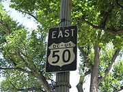
U.S. Route 50 in the District of Columbia
Encyclopedia
U.S. Route 50 is a major east–west route of the U.S. Highway system, stretching just over 3000 miles (4,828 km) from Ocean City, Maryland
, on the Atlantic Ocean, to West Sacramento, California
, nearly to the Pacific Ocean. In the District of Columbia, US 50 passes between Arlington County, Virginia
, and Prince George's County, Maryland
, predominantly along surface streets, including a part of Constitution Avenue
along the National Mall
.
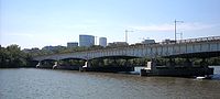

enter the District of Columbia from Arlington, Virginia
on the Theodore Roosevelt Bridge
over the Potomac River
. US 50 traffic exits I-66 to Constitution Avenue
, N.W.
, along the north side of the National Mall
, passing the Lincoln Memorial
, the Vietnam Veterans Memorial
, the White House
, the World War II Memorial
, and the Washington Monument
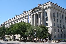
, then traveling between Federal Triangle
's office buildings on the north and the Smithsonian Institution
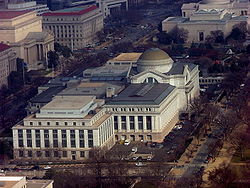
's National Museum of American History
, National Museum of Natural History
, and a National Gallery of Art
sculpture garden
to its south.
Near the National Art Gallery, Route 50 turns left onto 6th Street, N.W., and after several blocks, right onto New York Avenue, N.W.
The route continues northeast on New York Avenue through Northeast Washington
, passing the United States National Arboretum
. Beyond the Arboretum, New York Avenue becomes a freeway, with an off-level interchange with South Dakota Avenue, N.E. in the Fort Lincoln area. US 50 then crosses the Anacostia River
and continues into Maryland
, where it becomes the John Hanson Highway
and soon has an interchange with the Baltimore-Washington Parkway
.
is concurrent
with eastbound U.S. Route 50 along Constitution Avenue from 14th Street to 6th Street, N.W., and along 6th Street from Constitution Avenue to New York Avenue, N.W. Southbound U.S. Route 1 is concurrent with westbound U.S. Route 50 along L Street between 6th and 9th streets, N.W., and along 9th Street from L Street to Constitution Avenue. Interstate 66 and U.S. Route 50 are concurrent on the Theodore Roosevelt Bridge. U.S. Route 1 Alternate is concurrent with Route 50 along New York Avenue between 6th Street, N.W., and Bladensburg Road, N.E.
is at a signaled intersection with New York Avenue and 4th Street, N.W. At that intersection, traffic from New York Avenue in either direction may turn south onto Interstate 395, but traffic on northbound Interstate 395 may turn only right (east) onto New York Avenue, but not west toward downtown Washington.
Ocean City, Maryland
Ocean City, sometimes known as OC, or OCMD, is an Atlantic Ocean resort town in Worcester County, Maryland, United States. Ocean City is widely known in the Mid-Atlantic region of the United States and is a frequent destination for vacationers in that area...
, on the Atlantic Ocean, to West Sacramento, California
West Sacramento, California
West Sacramento is a city in Yolo County, California. It is contiguous with Sacramento, but is separated by the Sacramento River which is also the county line, so West Sacramento is in a different county than Sacramento...
, nearly to the Pacific Ocean. In the District of Columbia, US 50 passes between Arlington County, Virginia
Arlington County, Virginia
Arlington County is a county in the Commonwealth of Virginia. The land that became Arlington was originally donated by Virginia to the United States government to form part of the new federal capital district. On February 27, 1801, the United States Congress organized the area as a subdivision of...
, and Prince George's County, Maryland
Prince George's County, Maryland
Prince George's County is a county located in the U.S. state of Maryland, immediately north, east, and south of Washington, DC. As of 2010, it has a population of 863,420 and is the wealthiest African-American majority county in the nation....
, predominantly along surface streets, including a part of Constitution Avenue
Constitution Avenue
In Washington, D.C., Constitution Avenue is a major east-west street running just north of the United States Capitol in the city's Northwest and Northeast quadrants...
along the National Mall
National Mall
The National Mall is an open-area national park in downtown Washington, D.C., the capital of the United States. The National Mall is a unit of the National Park Service , and is administered by the National Mall and Memorial Parks unit...
.
Route description
Eastbound
U.S. Route 50 and Interstate 66Interstate 66
Interstate 66 is an Interstate Highway in the eastern United States. As indicated by its even route number, it runs in an east–west direction. Its western terminus is at Middletown, Virginia, at an intersection with Interstate 81; its eastern terminus is in Washington, D.C., at an...
enter the District of Columbia from Arlington, Virginia
Virginia
The Commonwealth of Virginia , is a U.S. state on the Atlantic Coast of the Southern United States. Virginia is nicknamed the "Old Dominion" and sometimes the "Mother of Presidents" after the eight U.S. presidents born there...
on the Theodore Roosevelt Bridge
Theodore Roosevelt Bridge
The Theodore Roosevelt Bridge is located in Washington, D.C. It carries Interstate 66 and U.S. Highway 50 over the Potomac River near the Kennedy Center, connecting the Rosslyn area of Arlington, Virginia, with Washington...
over the Potomac River
Potomac River
The Potomac River flows into the Chesapeake Bay, located along the mid-Atlantic coast of the United States. The river is approximately long, with a drainage area of about 14,700 square miles...
. US 50 traffic exits I-66 to Constitution Avenue
Constitution Avenue
In Washington, D.C., Constitution Avenue is a major east-west street running just north of the United States Capitol in the city's Northwest and Northeast quadrants...
, N.W.
Washington, D.C. (northwest)
Northwest is the northwestern quadrant of Washington, D.C., the capital of the United States, and is located north of the National Mall and west of North Capitol Street...
, along the north side of the National Mall
National Mall
The National Mall is an open-area national park in downtown Washington, D.C., the capital of the United States. The National Mall is a unit of the National Park Service , and is administered by the National Mall and Memorial Parks unit...
, passing the Lincoln Memorial
Lincoln Memorial
The Lincoln Memorial is an American memorial built to honor the 16th President of the United States, Abraham Lincoln. It is located on the National Mall in Washington, D.C. The architect was Henry Bacon, the sculptor of the main statue was Daniel Chester French, and the painter of the interior...
, the Vietnam Veterans Memorial
Vietnam Veterans Memorial
The Vietnam Veterans Memorial is a national memorial in Washington, D.C. It honors U.S. service members of the U.S. armed forces who fought in the Vietnam War, service members who died in service in Vietnam/South East Asia, and those service members who were unaccounted for during the War.Its...
, the White House
White House
The White House is the official residence and principal workplace of the president of the United States. Located at 1600 Pennsylvania Avenue NW in Washington, D.C., the house was designed by Irish-born James Hoban, and built between 1792 and 1800 of white-painted Aquia sandstone in the Neoclassical...
, the World War II Memorial
National World War II Memorial
The U.S. National World War II Memorial is a National Memorial dedicated to Americans who served in the armed forces and as civilians during World War II...
, and the Washington Monument
Washington Monument
The Washington Monument is an obelisk near the west end of the National Mall in Washington, D.C., built to commemorate the first U.S. president, General George Washington...
, then traveling between Federal Triangle
Federal Triangle
The Federal Triangle is a triangular area in Washington, D.C. formed by 15th Street NW, Constitution Avenue NW, Pennsylvania Avenue NW, and E Street NW. Federal Triangle is occupied by 10 large city and federal office buildings, all of which are part of the Pennsylvania Avenue National Historic...
's office buildings on the north and the Smithsonian Institution
Smithsonian Institution
The Smithsonian Institution is an educational and research institute and associated museum complex, administered and funded by the government of the United States and by funds from its endowment, contributions, and profits from its retail operations, concessions, licensing activities, and magazines...
's National Museum of American History
National Museum of American History
The National Museum of American History: Kenneth E. Behring Center collects, preserves and displays the heritage of the United States in the areas of social, political, cultural, scientific and military history. Among the items on display are the original Star-Spangled Banner and Archie Bunker's...
, National Museum of Natural History
National Museum of Natural History
The National Museum of Natural History is a natural history museum administered by the Smithsonian Institution, located on the National Mall in Washington, D.C., United States. Admission is free and the museum is open 364 days a year....
, and a National Gallery of Art
National Gallery of Art
The National Gallery of Art and its Sculpture Garden is a national art museum, located on the National Mall between 3rd and 9th Streets at Constitution Avenue NW, in Washington, DC...
sculpture garden
Sculpture garden
A sculpture garden is an outdoor garden dedicated to the presentation of sculpture, usually several permanently sited works in durable materials in landscaped surroundings....
to its south.
Near the National Art Gallery, Route 50 turns left onto 6th Street, N.W., and after several blocks, right onto New York Avenue, N.W.
New York Avenue (Washington, D.C.)
New York Avenue is one of the diagonal avenues radiating from the White House in Washington, D.C. It is a major east-west route in the city's Northwest and Northeast quadrants and connects downtown with points east and north of the city via Cheverly, Maryland, the John Hanson Highway and the...
The route continues northeast on New York Avenue through Northeast Washington
Washington, D.C. (northeast)
Northeast is the northeastern quadrant of Washington, D.C., the capital of the United States, and is located north of East Capitol Street and east of North Capitol Street...
, passing the United States National Arboretum
United States National Arboretum
The United States National Arboretum is an arboretum in Washington, D.C., operated by the United States Department of Agriculture's Agricultural Research Service as a division of the Henry A. Wallace Beltsville Agricultural Research Center...
. Beyond the Arboretum, New York Avenue becomes a freeway, with an off-level interchange with South Dakota Avenue, N.E. in the Fort Lincoln area. US 50 then crosses the Anacostia River
Anacostia River
The Anacostia River is a river in the Mid Atlantic region of the United States. It flows from Prince George's County in Maryland into Washington, D.C., where it joins with the Washington Channel to empty into the Potomac River at Buzzard Point. It is approximately long...
and continues into Maryland
Maryland
Maryland is a U.S. state located in the Mid Atlantic region of the United States, bordering Virginia, West Virginia, and the District of Columbia to its south and west; Pennsylvania to its north; and Delaware to its east...
, where it becomes the John Hanson Highway
U.S. Route 50 in Maryland
U.S. Route 50 is a major east–west route of the U.S. Highway system, stretching just over from Ocean City, Maryland on the Atlantic Ocean to West Sacramento, California. In the U.S. state of Maryland, US 50 exists in two sections. The longer of these serves as a major route connecting...
and soon has an interchange with the Baltimore-Washington Parkway
Baltimore-Washington Parkway
The Baltimore–Washington Parkway is a highway in the U.S. state of Maryland, running southwest from Baltimore to Washington, D.C. The road begins at an interchange with U.S. Route 50 and Maryland Route 201 near Cheverly in Prince George's County at the D.C...
.
Westbound
US Route 50 enters the District of Columbia from Maryland on the John Hanson Highway, which, as noted above, eventually becomes New York Avenue, N.E. The westbound route then follows New York Avenue into Northwest Washington, then turns right onto L Street, N.W., left onto 9th Street, N.W., and right onto Constitution Avenue, N.W. After passing the National Mall, it then joins Interstate 66, which it follows across the Potomac River into Virginia on the Theodore Roosevelt Bridge.Overlaps
Northbound U.S. Route 1U.S. Route 1 in the District of Columbia
With the District of Columbia, U.S. Route 1 passes between Arlington, Virginia and Mount Rainier, Maryland predominantly along surface streets. However, it forms a few overlaps with other routes.-Northbound:...
is concurrent
Concurrency (road)
A concurrency, overlap, or coincidence in a road network is an instance of one physical road bearing two or more different highway, motorway, or other route numbers...
with eastbound U.S. Route 50 along Constitution Avenue from 14th Street to 6th Street, N.W., and along 6th Street from Constitution Avenue to New York Avenue, N.W. Southbound U.S. Route 1 is concurrent with westbound U.S. Route 50 along L Street between 6th and 9th streets, N.W., and along 9th Street from L Street to Constitution Avenue. Interstate 66 and U.S. Route 50 are concurrent on the Theodore Roosevelt Bridge. U.S. Route 1 Alternate is concurrent with Route 50 along New York Avenue between 6th Street, N.W., and Bladensburg Road, N.E.
Interstate 395 junction
The northern terminus of Interstate 395Interstate 395 (District of Columbia-Virginia)
Interstate 395 in Washington, D.C., and Virginia is a 13 mile long spur route that begins at a junction with Interstate 95 in Springfield, Virginia and ends in northwest Washington, D.C. It passes underneath the National Mall near the United States Capitol and ends at a junction with U.S...
is at a signaled intersection with New York Avenue and 4th Street, N.W. At that intersection, traffic from New York Avenue in either direction may turn south onto Interstate 395, but traffic on northbound Interstate 395 may turn only right (east) onto New York Avenue, but not west toward downtown Washington.
History