

U.S. Route 287
Encyclopedia
U.S. Route 287 is a north–south United States highway. It is 1791 miles (2,882.3 km) long. It serves as the major truck route between the Texas cities of Fort Worth and Amarillo. The highway is broken into two segments by Yellowstone National Park
, where an unnumbered park road serves as a connector.
The highway's northern terminus is in Choteau, Montana
, 100 miles (161 km) south of the Canadian
border, at an intersection with U.S. Route 89
. Its southern terminus (as well as those of US 69
and US 96
) is in Port Arthur, Texas
at an intersection with State Highway 87, five miles (8 km) up the Sabine River
from the Gulf of Mexico
.
, US-287 remains within Cimarron County
, the county at the end of the Panhandle
. After crossing the state line north of Kerrick, Texas, the highway intersects State Highway 171
at its southern terminus. US-287 continues northwest, crossing the Beaver River
, toward Boise City
, the county seat. On the east side of town, the highway becomes concurrent with US-56, US-64, US-412, and SH-3. These five highways then enter the traffic circle in downtown Boise City. US-287 emerges from the north side of the circle, as well as US-385 and SH-3. These three highways head north to the Colorado state line. SH-3 ends there, while US-287 and US-385 continue onward into Colorado
.
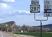 From Oklahoma, US-287 and US-385 enter into a very rural part of Colorado. They continue in a north/northwest direction through the state. The two Highways pass through the town of Campo
, and make an interchange with US-160 on the outskirts of Springfield. In Lamar
and Carlton, the highways make an interchange with US-50. Here US-385 heads east on US-50, and US-287-US-50 continue to the North. Just outside the town the highways make a sharp turn toward the west, and the road heading north is SH-196. South of Wiley
, US-50 heads west, while US-287 turns north toward Wiley. East of Eads, Colorado
US-287 turns toward the west again, briefly merging with SH-96. In Eads SH-96 continues toward the West, while US-287 turns toward the North. Near Kit Carson, US-287 again turns toward the west and merges with US-40. Near Limon, the two highways make 2 interchanges with I-70 before passing through Limon. Then the two highways merge with I-70. Near the outskirts of Denver
US-36 merges with the group of highways making the road, I-70,US-287,US-36,US-40. Just past SH-470, I-70 and US-36 split from US-287 and US-40. US-287 and US-40 continue west into downtown Denver. Just past the I-25, US-6, US-87, and US-85 interchange with SH-88, SH-88 runs South, US-40 heads west and US-287 turns toward the North, where it is named Federal Blvd. In the suburbs of Denver US-287 turns west once again and merges with SH-128. Just before US-36, US-287 turns north leaving SH-128, which at US-36 turns south and briefly merges with SH-121. In Lafayette
, US-287 briefly merges with SH-7. The two roads continue heading north, and in a short distance the two roads split with SH-7 heading west and US-287 heading north. It passes through Longmont
as the town's Main Street and is heavily trafficked. A branch of US-187 heads into Berthoud
. This old section of US-287 does not get back to the Highway. At Fort Collins
, US-287 merges with SH-14. On the edge of the mountains US-287 heads north, while SH-14 splits and heads toward the west. US-287 later passes into Wyoming.
to the east and the Medicine Bow Mountains
to the west. In Laramie, US-287 crosses I-80 and merges with US-30 and the two highways continue to head North. After passing Medicine Bow
, these highways turn west-southwest and return to I-80 near Walcott
, where they merge with the interstate west until Rawlins
. US-287 branches off from I-80 and US-30 and heads into the town. US-287 merges with State Highways 76, 80, and 30 for a short distance just outside Rawlins, though SH-36 ends when US-287 branches to the northwest as a stand-alone highway. It is also possible to take the Business US-287 (SH-80, SH-30) into Rawlins. In Downtown Rawlins, SH-80 and 30 head toward the west while Business US-287 heads to the north, merging with SH-789 where SH-30 and 80 split off the highway. A short while later Business US-287 and SH-789 merge with regular US-287 which made a detour around the city. US-287 and SH-789 stay merged all the way to Lander, Wyoming
, where SH-789 heads toward the northeast and US-287 heads toward the northwest. US-287 merges with US-26 in the very mountainous terrain of West/Central Wyoming, and the two highways head west. The highways enter Grand Teton National Park and make a big interchange in the town of Moran
. In Moran, US-287 and US-26 meet US-191, US-89. US-26 heads south merging with US-191 and US-89. US-287 heads North merging with US-191, US-89. At this point the road is US-287, US-191 and US-89, and the three highways continue to run through Yellowstone. Near West Thumb, US-287, US-191, US-89, meet with US-16, US-14 and US-20. While US 14 and 16 end here, US-20 merges with the highways making the road US-287, US-191, US-89 and US-20. The four highways actually pass the main Visitor's Center of Yellowstone National Park. In the middle of the park, US-89 heads east, while US-287, US-191, and US-20 continue west.
State Line in Yellowstone National Park. Just outside the park boundary in West Yellowstone
, US-20 heads towards the west while US-287 and US-191 turn north. US-287 and US-191 split north of the town. US-287 heads toward the northwest and US-191 heads northeast, going back into Yellowstone and eventually crossing into Wyoming again. North of Sappington, US-287 merges with SH-2, and runs northeast. At I-90, SH-2 ends and US-287 continues to head north. In Townsend
, US-287 merges with US-12 and the two highways continue north. At I-15 (near Helena
), US-287 continues north on I-15 and US-12 heads west through downtown Helena. Northeast of Wolf Creek
, US-287 and I-15 split with US-287 heading northwest and I-15 heading northeast. US-287 ends at US-89 in Choteau
.
to Denver, Colorado
. The route was extended southward to the Gulf Coast
at Port Arthur, Texas
in 1940, and northward into Montana to US 89
at Choteau, Montana in 1965. U.S. 89 continues north of Choteau into Alberta
as Provincial Highway 2 through the major cities of Calgary and Edmonton, connecting with a Canadian link to the Alaska Highway
in the latter.
Included in the route of US 287 is former U.S. Route 370, which was commissioned in 1926 and connected Amarillo
to Bowie
, overlapping US 70
between Vernon
and Wichita Falls
.
The Canada to Gulf Highway Association, which later became the U.S. Highway 287 Association, was active from the 1910s until the 1970s to promote US 287 as a popular tourist route, and was composed of members from businesses and organizations in cities along the route.
The Wyoming state transportation department started widening U.S. Route 287 in 2009.
List of sections (south to north):
Yellowstone National Park
Yellowstone National Park, established by the U.S. Congress and signed into law by President Ulysses S. Grant on March 1, 1872, is a national park located primarily in the U.S. state of Wyoming, although it also extends into Montana and Idaho...
, where an unnumbered park road serves as a connector.
The highway's northern terminus is in Choteau, Montana
Choteau, Montana
Choteau is a city in and the county seat of Teton County, Montana, United States. It lies along U.S. Routes 89 and 287 about east of the Rocky Mountains, near Flathead National Forest, the Rocky Mountain Division of Lewis and Clark National Forest, and Glacier National Park. The population was...
, 100 miles (161 km) south of the Canadian
Canada
Canada is a North American country consisting of ten provinces and three territories. Located in the northern part of the continent, it extends from the Atlantic Ocean in the east to the Pacific Ocean in the west, and northward into the Arctic Ocean...
border, at an intersection with U.S. Route 89
U.S. Route 89
U.S. Route 89 is a north–south United States Highway with two sections, and one former section. The southern section runs for 848 miles from Flagstaff, Arizona, to the southern entrance of Yellowstone National Park...
. Its southern terminus (as well as those of US 69
U.S. Route 69
U.S. Route 69 is a north–south United States highway. When it was first created, it was only long, but it has since been expanded into a Minnesota to Texas cross-country route. The highway's southern terminus is in Port Arthur, Texas at an intersection with State Highway 87...
and US 96
U.S. Route 96
U.S. Route 96 is a north–south U.S. Route in the U.S. state of Texas. Its number is a violation of the standard numbering convention, as even-numbered two-digit highways are east–west routes by rule....
) is in Port Arthur, Texas
Port Arthur, Texas
-Demographics:As of the 2000 census, there were 57,755 people, 21,839 households, and 14,675 families residing in the city. The population density was 696.5 people per square mile . There were 24,713 housing units at an average density of 298.0 per square mile...
at an intersection with State Highway 87, five miles (8 km) up the Sabine River
Sabine River (Texas-Louisiana)
The Sabine River is a river, long, in the U.S. states of Texas and Louisiana. In its lower course, it forms part of the boundary between the two states and empties into Sabine Lake, an estuary of the Gulf of Mexico. The river formed part of the United States-Mexican international boundary during...
from the Gulf of Mexico
Gulf of Mexico
The Gulf of Mexico is a partially landlocked ocean basin largely surrounded by the North American continent and the island of Cuba. It is bounded on the northeast, north and northwest by the Gulf Coast of the United States, on the southwest and south by Mexico, and on the southeast by Cuba. In...
.
Oklahoma
In OklahomaOklahoma
Oklahoma is a state located in the South Central region of the United States of America. With an estimated 3,751,351 residents as of the 2010 census and a land area of 68,667 square miles , Oklahoma is the 28th most populous and 20th-largest state...
, US-287 remains within Cimarron County
Cimarron County, Oklahoma
Cimarron County is a county located in the U.S. state of Oklahoma. Throughout most of its history it has had the smallest population and the lowest population density of any county in Oklahoma. As of 2010 census, the population was 2,475...
, the county at the end of the Panhandle
Oklahoma Panhandle
The Oklahoma Panhandle is the extreme western region of the state of Oklahoma, comprising Cimarron County, Texas County, and Beaver County. Its name comes from the similarity of shape to the handle of a cooking pan....
. After crossing the state line north of Kerrick, Texas, the highway intersects State Highway 171
State Highway 171 (Oklahoma)
State Highway 171, abbreviated as SH-171 or OK-171, is a state highway in Cimarron County, Oklahoma, in the Oklahoma Panhandle. It runs for 21½ miles north and south through the eastern part of the county, connecting U.S. Highway 287 near the Oklahoma-Texas state line to US-56 in Keyes...
at its southern terminus. US-287 continues northwest, crossing the Beaver River
Beaver River (Oklahoma)
The Beaver River is the historic name for an intermittent river in Oklahoma that drains most of the Oklahoma Panhandle. It is also known as the North Canadian River. Both names are in common use. By one convention the headwaters of the Beaver River are at the convergence of the Corrumpa, Rafael,...
, toward Boise City
Boise City, Oklahoma
Boise City is a city in and the county seat of Cimarron County, Oklahoma, United States. The population was 1,266 at the 2010 census.'Boise' rhymes with 'voice'...
, the county seat. On the east side of town, the highway becomes concurrent with US-56, US-64, US-412, and SH-3. These five highways then enter the traffic circle in downtown Boise City. US-287 emerges from the north side of the circle, as well as US-385 and SH-3. These three highways head north to the Colorado state line. SH-3 ends there, while US-287 and US-385 continue onward into Colorado
Colorado
Colorado is a U.S. state that encompasses much of the Rocky Mountains as well as the northeastern portion of the Colorado Plateau and the western edge of the Great Plains...
.
Colorado
Campo, Colorado
The town of Campo is a Statutory Town located in Baca County, Colorado, United States. The population was 150 at the 2000 census. The town is situated on the Great Plains, straddling U.S...
, and make an interchange with US-160 on the outskirts of Springfield. In Lamar
Lamar, Colorado
The City of Lamar is a Home Rule Municipality that is the county seat and the most populous city of Prowers County, Colorado, United States. The city population was 8,869 at the U.S...
and Carlton, the highways make an interchange with US-50. Here US-385 heads east on US-50, and US-287-US-50 continue to the North. Just outside the town the highways make a sharp turn toward the west, and the road heading north is SH-196. South of Wiley
Wiley, Colorado
Wiley is a Statutory Town in Prowers County, Colorado, United States. The population was 483 at the 2000 census.-Geography:Wiley is located at ....
, US-50 heads west, while US-287 turns north toward Wiley. East of Eads, Colorado
Eads, Colorado
The Town of Eads is a Statutory Town that is the county seat and the most populous town of Kiowa County, Colorado, United States. The town population was 747 at the 2000 census...
US-287 turns toward the west again, briefly merging with SH-96. In Eads SH-96 continues toward the West, while US-287 turns toward the North. Near Kit Carson, US-287 again turns toward the west and merges with US-40. Near Limon, the two highways make 2 interchanges with I-70 before passing through Limon. Then the two highways merge with I-70. Near the outskirts of Denver
Denver, Colorado
The City and County of Denver is the capital and the most populous city of the U.S. state of Colorado. Denver is a consolidated city-county, located in the South Platte River Valley on the western edge of the High Plains just east of the Front Range of the Rocky Mountains...
US-36 merges with the group of highways making the road, I-70,US-287,US-36,US-40. Just past SH-470, I-70 and US-36 split from US-287 and US-40. US-287 and US-40 continue west into downtown Denver. Just past the I-25, US-6, US-87, and US-85 interchange with SH-88, SH-88 runs South, US-40 heads west and US-287 turns toward the North, where it is named Federal Blvd. In the suburbs of Denver US-287 turns west once again and merges with SH-128. Just before US-36, US-287 turns north leaving SH-128, which at US-36 turns south and briefly merges with SH-121. In Lafayette
Lafayette, Colorado
The City of Lafayette is a Home Rule Municipality located in Boulder County, Colorado, United States. The United States Census Bureau estimates that the city population was 23,884 on 2005-07-01.- Geography :Lafayette is located at ....
, US-287 briefly merges with SH-7. The two roads continue heading north, and in a short distance the two roads split with SH-7 heading west and US-287 heading north. It passes through Longmont
Longmont, Colorado
Longmont is a Home Rule Municipality in Boulder and Weld counties in the U.S. state of Colorado. Longmont is located in Northern Colorado. Longmont is the 13th most populous city in the State of Colorado. The word "Longmont" comes from Longs Peak, a prominent mountain named for explorer Stephen H....
as the town's Main Street and is heavily trafficked. A branch of US-187 heads into Berthoud
Berthoud, Colorado
Berthoud is a Statutory Town in Larimer and Weld counties in the U.S. state of Colorado. Berthoud is situated north of the Little Thompson River, approximately halfway between the cities of Fort Collins, Colorado and Denver, Colorado along the Front Range Urban Corridor...
. This old section of US-287 does not get back to the Highway. At Fort Collins
Fort Collins, Colorado
Fort Collins is a Home Rule Municipality situated on the Cache La Poudre River along the Colorado Front Range, and is the county seat and most populous city of Larimer County, Colorado, United States. Fort Collins is located north of the Colorado State Capitol in Denver. With a 2010 census...
, US-287 merges with SH-14. On the edge of the mountains US-287 heads north, while SH-14 splits and heads toward the west. US-287 later passes into Wyoming.
Wyoming
US-287 enters Wyoming through a pass between the Laramie MountainsLaramie Mountains
The Laramie Mountains are a range of moderately high peaks on the eastern edge of the Rocky Mountains in the U.S states of Wyoming and Colorado. The range is the northernmost extension of the line of the ranges along the eastern side of the Rockies, and in particular of the higher peaks of the...
to the east and the Medicine Bow Mountains
Medicine Bow Mountains
The Medicine Bow Mountains are a mountain range in the Rocky Mountains that extend for from northern Colorado into southern Wyoming. The northern extent of this range is the sub-range the Snowy Range...
to the west. In Laramie, US-287 crosses I-80 and merges with US-30 and the two highways continue to head North. After passing Medicine Bow
Medicine Bow, Wyoming
Medicine Bow is a town in Carbon County, Wyoming, United States. The population was 304 at the 2010 census.-Geography:Medicine Bow is located at ....
, these highways turn west-southwest and return to I-80 near Walcott
Walcott, Wyoming
Walcott is an unincorporated community in central Carbon County, Wyoming, United States. It lies along local roads near Interstate 80 and the concurrent U.S. Routes 30 and 287, east of the city of Rawlins, the county seat of Carbon County. Its elevation is 6,627 feet...
, where they merge with the interstate west until Rawlins
Rawlins, Wyoming
Rawlins is a city in Carbon County, Wyoming, United States. The population was 8,538 at the 2000 census. It is the county seat of Carbon County...
. US-287 branches off from I-80 and US-30 and heads into the town. US-287 merges with State Highways 76, 80, and 30 for a short distance just outside Rawlins, though SH-36 ends when US-287 branches to the northwest as a stand-alone highway. It is also possible to take the Business US-287 (SH-80, SH-30) into Rawlins. In Downtown Rawlins, SH-80 and 30 head toward the west while Business US-287 heads to the north, merging with SH-789 where SH-30 and 80 split off the highway. A short while later Business US-287 and SH-789 merge with regular US-287 which made a detour around the city. US-287 and SH-789 stay merged all the way to Lander, Wyoming
Lander, Wyoming
Lander is a city in, and the county seat of, Fremont County, Wyoming, United States. Named for transcontinental explorer Frederick W. Lander, Lander is located in central Wyoming, along the Middle Fork of the Popo Agie River. A tourism center with several dude ranches nearby, Lander is located just...
, where SH-789 heads toward the northeast and US-287 heads toward the northwest. US-287 merges with US-26 in the very mountainous terrain of West/Central Wyoming, and the two highways head west. The highways enter Grand Teton National Park and make a big interchange in the town of Moran
Moran, Wyoming
Moran is an unincorporated community in south central Teton County, Wyoming, United States, which serves as one of the principal fee collection entrances to Grand Teton National Park. It lies in Grand Teton National Park northeast of the city of Jackson, the county seat of Teton County, at the...
. In Moran, US-287 and US-26 meet US-191, US-89. US-26 heads south merging with US-191 and US-89. US-287 heads North merging with US-191, US-89. At this point the road is US-287, US-191 and US-89, and the three highways continue to run through Yellowstone. Near West Thumb, US-287, US-191, US-89, meet with US-16, US-14 and US-20. While US 14 and 16 end here, US-20 merges with the highways making the road US-287, US-191, US-89 and US-20. The four highways actually pass the main Visitor's Center of Yellowstone National Park. In the middle of the park, US-89 heads east, while US-287, US-191, and US-20 continue west.
Montana
US-287, US-191, and US-20 cross the MontanaMontana
Montana is a state in the Western United States. The western third of Montana contains numerous mountain ranges. Smaller, "island ranges" are found in the central third of the state, for a total of 77 named ranges of the Rocky Mountains. This geographical fact is reflected in the state's name,...
State Line in Yellowstone National Park. Just outside the park boundary in West Yellowstone
West Yellowstone, Montana
West Yellowstone is a town in Gallatin County, Montana, adjacent to Yellowstone National Park. The population was 1,177 at the 2000 census. The town is served by Yellowstone Airport...
, US-20 heads towards the west while US-287 and US-191 turn north. US-287 and US-191 split north of the town. US-287 heads toward the northwest and US-191 heads northeast, going back into Yellowstone and eventually crossing into Wyoming again. North of Sappington, US-287 merges with SH-2, and runs northeast. At I-90, SH-2 ends and US-287 continues to head north. In Townsend
Townsend, Montana
Townsend is a city in and the county seat of Broadwater County, Montana, United States. The population was 1,867 at the 2000 census.-History:...
, US-287 merges with US-12 and the two highways continue north. At I-15 (near Helena
Helena, Montana
Helena is the capital city of the U.S. state of Montana and the county seat of Lewis and Clark County. The 2010 census put the population at 28,180. The local daily newspaper is the Independent Record. The Helena Brewers minor league baseball and Helena Bighorns minor league hockey team call the...
), US-287 continues north on I-15 and US-12 heads west through downtown Helena. Northeast of Wolf Creek
Wolf Creek, Montana
Wolf Creek is an unincorporated community in Lewis and Clark County, Montana, United States. Wolf Creek is located along Interstate 15 north of Helena. Wolf Creek has a post office with ZIP code 59648.- In popular culture :...
, US-287 and I-15 split with US-287 heading northwest and I-15 heading northeast. US-287 ends at US-89 in Choteau
Choteau, Montana
Choteau is a city in and the county seat of Teton County, Montana, United States. It lies along U.S. Routes 89 and 287 about east of the Rocky Mountains, near Flathead National Forest, the Rocky Mountain Division of Lewis and Clark National Forest, and Glacier National Park. The population was...
.
History
When US 287 was first commissioned in 1939, it extended only from the south entrance of Yellowstone National ParkYellowstone National Park
Yellowstone National Park, established by the U.S. Congress and signed into law by President Ulysses S. Grant on March 1, 1872, is a national park located primarily in the U.S. state of Wyoming, although it also extends into Montana and Idaho...
to Denver, Colorado
Denver, Colorado
The City and County of Denver is the capital and the most populous city of the U.S. state of Colorado. Denver is a consolidated city-county, located in the South Platte River Valley on the western edge of the High Plains just east of the Front Range of the Rocky Mountains...
. The route was extended southward to the Gulf Coast
Gulf of Mexico
The Gulf of Mexico is a partially landlocked ocean basin largely surrounded by the North American continent and the island of Cuba. It is bounded on the northeast, north and northwest by the Gulf Coast of the United States, on the southwest and south by Mexico, and on the southeast by Cuba. In...
at Port Arthur, Texas
Port Arthur, Texas
-Demographics:As of the 2000 census, there were 57,755 people, 21,839 households, and 14,675 families residing in the city. The population density was 696.5 people per square mile . There were 24,713 housing units at an average density of 298.0 per square mile...
in 1940, and northward into Montana to US 89
U.S. Route 89
U.S. Route 89 is a north–south United States Highway with two sections, and one former section. The southern section runs for 848 miles from Flagstaff, Arizona, to the southern entrance of Yellowstone National Park...
at Choteau, Montana in 1965. U.S. 89 continues north of Choteau into Alberta
Alberta
Alberta is a province of Canada. It had an estimated population of 3.7 million in 2010 making it the most populous of Canada's three prairie provinces...
as Provincial Highway 2 through the major cities of Calgary and Edmonton, connecting with a Canadian link to the Alaska Highway
Alaska Highway
The Alaska Highway was constructed during World War II for the purpose of connecting the contiguous U.S. to Alaska through Canada. It begins at the junction with several Canadian highways in Dawson Creek, British Columbia and runs to Delta Junction, Alaska, via Whitehorse, Yukon...
in the latter.
Included in the route of US 287 is former U.S. Route 370, which was commissioned in 1926 and connected Amarillo
Amarillo, Texas
Amarillo is the 14th-largest city, by population, in the state of Texas, the largest in the Texas Panhandle, and the seat of Potter County. A portion of the city extends into Randall County. The population was 190,695 at the 2010 census...
to Bowie
Bowie, Texas
Bowie is a city in Montague County, Texas, United States. The population was 5,219 at the 2000 census.-Geography:According to the United States Census Bureau, Bowie has a total area of , of which, of it is land and of it is water.-Demographics:...
, overlapping US 70
U.S. Route 70
U.S. Route 70 is an east–west United States highway that runs for 2,385 miles from eastern North Carolina to east-central Arizona. As can be derived from its number, it is a major east–west highway of the Southern and Southwestern United States...
between Vernon
Vernon, Texas
Vernon is a city in Wilbarger County, Texas, United States. As of the 2000 census, the population was 11,660; it was 11,077 in the 2005 census estimate. Vernon is the county seat of Wilbarger County....
and Wichita Falls
Wichita Falls, Texas
Wichita Falls is a city in and the county seat of Wichita County, Texas, United States, United States. Wichita Falls is the principal city of the Wichita Falls Metropolitan Statistical Area, which encompasses all of Archer, Clay and Wichita counties. According to the U.S. Census estimate of 2010,...
.
The Canada to Gulf Highway Association, which later became the U.S. Highway 287 Association, was active from the 1910s until the 1970s to promote US 287 as a popular tourist route, and was composed of members from businesses and organizations in cities along the route.
The Wyoming state transportation department started widening U.S. Route 287 in 2009.
US-287 as a freeway
In some spots US-287 is built up to freeway standards (a freeway has exits and frontage roads with no at-grade intersections).List of sections (south to north):
- From just NW of SH-73 in Port Arthur to Lumberton.
- ConcurrencyConcurrency (road)A concurrency, overlap, or coincidence in a road network is an instance of one physical road bearing two or more different highway, motorway, or other route numbers...
with I-45 near Corsicana to when it splits from I-45 near Ennis. - Around the Waxahachie area.
- Around Midlothian as a freeway. Intersects US 67 with direct connects. Begins at 287 business west end and Midlothian Parkway east end of freeway bypass.
- Through Arlington, and Mansfield, Texas until it intersects with TX Highway 360.
- Through the City of Fort Worth itself and the northern and southern suburbs of the City (including the portion when it is concurrent with I-35W).
- Around the Bowie area.
- Around the Henrietta area.
- From SE of Wichita Falls all the way to west of Electra (including the portion concurrent with I-44).
- Around the Vernon area.
- The part when it is concurrent with I-40 in Amarillo.
- The northern suburbs of Amarillo (last area where highway is a freeway while not being concurrent with an interstate).
- From Limon to Denver when it is concurrent with I-70.
- From near Walcott to Rawlins when it is concurrent with I-80.
- From when it merges with I-15 near Helena to near Wolf Creek, where it splits from the highway (last freeway section).