

U.S. Route 24 in Colorado
Encyclopedia
U.S. Route 24
is a major east–west route in the U.S. state
of Colorado
.
, starting near Minturn
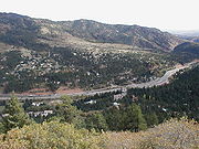
. It then continues east for about 30 miles Leadville
where it turns south and goes to Buena Vista
where it becomes concurrent with US 285. It continues with Highway 285 to the small community of Antero Junction. After that, it spends its time as a mountainous two-lane highway through the town of Divide
, where it meets SH 67
. These highways overlap to Woodland Park
. From there it passes through Crystola
, Green Mountain Falls
, Cascade
as a 4-lane highway. Through Manitou Springs
and Colorado Springs
, where the road is known as Midland Expressway. It goes through the Springs and then continues northeast through several towns such as Falcon
, Peyton
, the city of Calhan
, Ramah
, Simla
, and Matheson
. When US 24 reaches Limon, it junctions with I-70/US 40/US 287/SH 71. It continues east (parallel to I-70) to Burlington
where it joins I-70 to the Kansas
state line.
!County
!Location
!Mile
!Destinations
!Notes
|-
|Eagle
|Minturn
|0.000
|
|Western terminus of US 24
|-
|rowspan=2|Lake
|Leadville
|31
|
|
|-
|
|47
|
|
|-
|Chaffee
|Johnson Village
|68.5
|
|Southern end of US 285 overlap
|-
|rowspan=2|Park
|
|82
|
|Northern end of US 285 overlap
|-
|Hartsel
|94
|
|-
|rowspan=3|Teller
|Divide
|132
|
|Western end of SH 67 overlap
|-
|Woodland Park
|139.5
|
|Eastern end of SH 67 overlap
|-
|
|145
|Pikes Peak Highway
|
|-
|rowspan=21|El Paso
|rowspan=2|Manitou Springs
|150
|
|
|-
|153
|
|
|-
|rowspan=12|Colorado Springs
|158
|
|Northern end of I-25 overlap
|-
|159
|
|I-25 exit 140
|-
|160
|
|Southern end of I-25 overlap
|-
|161.5
|Union Boulevard
|
|-
|163
|
|Western end of Fountain Blvd overlap
|-
|164.5
|
|
|-
|167
| – Colorado Springs Municipal Airport
|Eastern end of Fountain Blvd overlap
Southern end of SH 21/Powers Blvd overlap
|-
|168
|Airport Road east – Peterson Air Force Base
|
|-
|169
|
|Northern end of SH 21/Powers Blvd overlap
|-
|169
|Platte Avenue west – Downtown Colorado Springs
|
|-
|169.5
|Peterson Road south – Peterson Air Force Base
|
|-
|169.5
|
|
|-
|
|170.5
| – Schriever Air Force Base
, Colorado Springs East Airport
, Punkin Center
|
|-
|Falcon
|178
|Woodmen Road
|
|-
|
|180
|Judge Orr Road east – Meadow Lake Airport
|
|-
|
|183
|/Elbert Road
– Elbert
, Kiowa
|
|-
|Peyton
|188
|Peyton Highway
|-
|
|192
|Ellicott Highway
|
|-
|Calhan
|198
|Calhan Highway
|
|-
|rowspan=2|Elbert
|Simla
|211
|County Road 125
|rowspan=2|Connect to SH 86
|-
|Matheson
|218
|County Road 149
|-
|rowspan=4|Lincoln
|rowspan=3|Limon
|230
|

 US 40
US 40
/US 287 north – Denver, SH 71
south – Punkin Center
|Western end of US 40/287/SH 71 overlap
|-
|232
|
|Eastern end of SH 71 overlap
|-
|233
|
|
|-
|
|234
| I-70
I-70
east – Burlington
, US 40
/US 287 south – Kit Carson
|Eastern end of US 40/287 overlap, western end of I-70 overlap
|-
|rowspan=7|Kit Carson
|rowspan=2|Seibert
|277
|
|Eastern overlap of I-70
|-
|277.5
|
|
|-
|Stratton
|293
|
|
|-
|rowspan=3|Burlington
|309
|
|Western end of US 385 overlap
|-
|310
|
|Eastern end of US 385 overlap
|-
|310.5
|
|Western end of I-70 overlap
|-
|
|318
|
|Kansas state line; Eastern terminus of US 24 in Colorado
U.S. Route 24
U.S. Route 24 is one of the original United States highways of 1926. It originally ran from Pontiac, Michigan, in the east to Kansas City, Missouri, in the west. Today, the highway's eastern terminus is west of Clarkston, Michigan, at an intersection with I-75 and its western terminus is near...
is a major east–west route in the U.S. state
U.S. state
A U.S. state is any one of the 50 federated states of the United States of America that share sovereignty with the federal government. Because of this shared sovereignty, an American is a citizen both of the federal entity and of his or her state of domicile. Four states use the official title of...
of Colorado
Colorado
Colorado is a U.S. state that encompasses much of the Rocky Mountains as well as the northeastern portion of the Colorado Plateau and the western edge of the Great Plains...
.
Route description
It traverses the Rocky MountainsRocky Mountains
The Rocky Mountains are a major mountain range in western North America. The Rocky Mountains stretch more than from the northernmost part of British Columbia, in western Canada, to New Mexico, in the southwestern United States...
, starting near Minturn
Minturn, Colorado
Minturn is a Home Rule Municipality in Eagle County, Colorado, United States. The population was 1,068 at the 2000 census.-Geography:Minturn is located at ....
. It then continues east for about 30 miles Leadville
Leadville, Colorado
Leadville is a Statutory City that is the county seat of, and the only municipality in, Lake County, Colorado, United States. Situated at an elevation of , Leadville is the highest incorporated city and the second highest incorporated municipality in the United States...
where it turns south and goes to Buena Vista
Buena Vista, Colorado
Buena Vista is a Statutory Town in Chaffee County, Colorado, United States. The population was 2,195 at the 2000 census.Buena Vista is located in central Colorado roughly midway between Salida and Leadville in the Upper Arkansas River Valley at an elevation of . The area between Buena Vista and...
where it becomes concurrent with US 285. It continues with Highway 285 to the small community of Antero Junction. After that, it spends its time as a mountainous two-lane highway through the town of Divide
Divide, Colorado
Divide is a census-designated place and a U.S. Post Office in Teller County, Colorado, United States. The population as of the 2010 Census was 127....
, where it meets SH 67
Colorado State Highway 67
State Highway 67 is a long state highway encompassing five distinct segments in south-central Colorado. The route runs north from Wetmore to Sedalia, Colorado, traversing the former route of the Florence and Cripple Creek Railroad through Phantom Canyon as a county road and carrying part of the...
. These highways overlap to Woodland Park
Woodland Park, Colorado
The City of Woodland Park is a Home Rule Municipality that is the most populous city in Teller County, Colorado, United States and is immediately west of El Paso County and the unincorporated community of Crystola. Many residents in this bedroom community, which is surrounded by the one-million...
. From there it passes through Crystola
Crystola, Colorado
Crystola is an unincorporated town in Teller County, Colorado, United States. ZIP code 80863 serves Crystola, but mail must be addressed to Woodland Park.-Geography:Crystola is located at ....
, Green Mountain Falls
Green Mountain Falls, Colorado
Green Mountain Falls is a Statutory Town in El Paso and Teller counties in the U.S. state of Colorado. The population was 773 at the 2000 census.-Geography:Green Mountain Falls is located at ....
, Cascade
Cascade, Colorado
Cascade is an unincorporated town and U.S. Post Office in El Paso County, Colorado, United States. The ZIP Code of the Cascade Post Office is 80809.-History:...
as a 4-lane highway. Through Manitou Springs
Manitou Springs, Colorado
The city of Manitou Springs is a Home Rule Municipality located in El Paso County, Colorado, United States. The population was 4,980 at the 2000 census.Students are served by Manitou Springs School District 14 and Manitou Springs High School....
and Colorado Springs
Colorado Springs, Colorado
Colorado Springs is a Home Rule Municipality that is the county seat and most populous city of El Paso County, Colorado, United States. Colorado Springs is located in South-Central Colorado, in the southern portion of the state. It is situated on Fountain Creek and is located south of the Colorado...
, where the road is known as Midland Expressway. It goes through the Springs and then continues northeast through several towns such as Falcon
Falcon, Colorado
Falcon is an unincorporated exurb in El Paso County, Colorado, United States. It lies along US 24 about 14 miles northeast of Colorado Springs. A railroad hub in the early 20th century, the town spent several decades as a quiet ranching community until it experienced rapid residential growth...
, Peyton
Peyton, Colorado
Peyton is a census-designated place and a U.S. Post Office in El Paso County, Colorado, United States. The population as of the 2010 Census was 250. The nearby unincorporated area of Falcon also uses zip code 80831...
, the city of Calhan
Calhan, Colorado
The town of Calhan is a Statutory Town in El Paso County, Colorado, United States. Calhan straddles U.S. Route 24. The population was 896 at the 2000 census...
, Ramah
Ramah, Colorado
The town of Ramah is a Statutory Town in El Paso County, Colorado, United States. The population was 220, as estimated in 2007.-Geography:Ramah is located at ....
, Simla
Simla, Colorado
The Town of Simla is a Statutory Town in Elbert County, Colorado, United States. The population was estimated to be 728 in 2007.-History:Simla was founded in 1909, by a man with the name of Altman. Simla was named because the daughter of a railroad official was reading a book about India when she...
, and Matheson
Matheson, Colorado
Matheson is an unincorporated town and a U.S. Post Office in Elbert County, Colorado, United States. The Matheson Post Office has the ZIP Code 80830.Established in the mid 1880's by Duncan Matheson a native of Scotland.Mr...
. When US 24 reaches Limon, it junctions with I-70/US 40/US 287/SH 71. It continues east (parallel to I-70) to Burlington
Burlington, Colorado
Burlington is a Home Rule Municipality, county seat, most populous place and only city in Kit Carson County, Colorado, United States. Its population was 4191 at the U.S. Census 2010...
where it joins I-70 to the Kansas
Kansas
Kansas is a US state located in the Midwestern United States. It is named after the Kansas River which flows through it, which in turn was named after the Kansa Native American tribe, which inhabited the area. The tribe's name is often said to mean "people of the wind" or "people of the south...
state line.
Junction list
{| class="wikitable"!County
!Location
!Mile
!Destinations
!Notes
|-
|Eagle
Eagle County, Colorado
Eagle County is the thirteenth most populous of the 64 counties of the State of Colorado in the United States. The county is named for the Eagle River. The county population was 41,659 at U.S. Census 2000. The county seat is the Town of Eagle...
|Minturn
Minturn, Colorado
Minturn is a Home Rule Municipality in Eagle County, Colorado, United States. The population was 1,068 at the 2000 census.-Geography:Minturn is located at ....
|0.000
|
|Western terminus of US 24
|-
|rowspan=2|Lake
Lake County, Colorado
Lake County is one of the 64 counties of the State of Colorado of the United States. The highest natural point in Colorado and the entire Rocky Mountains is the summit of Mount Elbert in Lake County at 14,440 feet elevation. The county population was 7,812 at U.S. Census 2000. The county seat...
|Leadville
Leadville, Colorado
Leadville is a Statutory City that is the county seat of, and the only municipality in, Lake County, Colorado, United States. Situated at an elevation of , Leadville is the highest incorporated city and the second highest incorporated municipality in the United States...
|31
|
|
|-
|
|47
|
|
|-
|Chaffee
Chaffee County, Colorado
Chaffee County is one of the 64 counties of the state of Colorado of the United States. The county population was 16,242 at U.S. Census 2000. The county seat is Salida.-History:...
|Johnson Village
Johnson Village, Colorado
Johnson Village is a small unincorporated community located in central Chaffee County, Colorado in the United States. It is located along the west side of the Arkansas River, where the river is bridged by U.S. Highway 24. It is approximately three miles south of the town of Buena Vista. The...
|68.5
|
|Southern end of US 285 overlap
|-
|rowspan=2|Park
Park County, Colorado
Park County is the 17th most extensive of the 64 counties of the State of Colorado of the United States. The county was named after the large geographic region known as South Park, which was named by early fur traders and trappers in the area. The geographic center of the State of Colorado is...
|
|82
|
|Northern end of US 285 overlap
|-
|Hartsel
Hartsel, Colorado
Hartsel is an unincorporated town and a U.S. Post Office located in Park County, Colorado, United States. Hartsel was founded in 1880. Located at the geographic center of the state, it is often referred to as "The Heart of Colorado". The community's namesake is Samuel Hartsel, a local cattle...
|94
|
|-
|rowspan=3|Teller
Teller County, Colorado
Teller County is the 22nd most populous of the 64 counties of the State of Colorado of the United States. The county population was 20,555 at U.S. Census 2000. The county seat is Cripple Creek, and the most populous city is Woodland Park...
|Divide
Divide, Colorado
Divide is a census-designated place and a U.S. Post Office in Teller County, Colorado, United States. The population as of the 2010 Census was 127....
|132
|
|Western end of SH 67 overlap
|-
|Woodland Park
Woodland Park, Colorado
The City of Woodland Park is a Home Rule Municipality that is the most populous city in Teller County, Colorado, United States and is immediately west of El Paso County and the unincorporated community of Crystola. Many residents in this bedroom community, which is surrounded by the one-million...
|139.5
|
|Eastern end of SH 67 overlap
|-
|
|145
|Pikes Peak Highway
|
|-
|rowspan=21|El Paso
El Paso County, Colorado
El Paso County is the most populous of the 64 counties of the state of Colorado of the United States, now more populous than Denver County. The United States Census Bureau concluded that the county population was 622,371 in 2010. In recent years, the population had come closer to that of Denver...
|rowspan=2|Manitou Springs
Manitou Springs, Colorado
The city of Manitou Springs is a Home Rule Municipality located in El Paso County, Colorado, United States. The population was 4,980 at the 2000 census.Students are served by Manitou Springs School District 14 and Manitou Springs High School....
|150
|
|
|-
|153
|
|
|-
|rowspan=12|Colorado Springs
Colorado Springs, Colorado
Colorado Springs is a Home Rule Municipality that is the county seat and most populous city of El Paso County, Colorado, United States. Colorado Springs is located in South-Central Colorado, in the southern portion of the state. It is situated on Fountain Creek and is located south of the Colorado...
|158
|
|Northern end of I-25 overlap
|-
|159
|
|I-25 exit 140
|-
|160
|
|Southern end of I-25 overlap
|-
|161.5
|Union Boulevard
|
|-
|163
|
|Western end of Fountain Blvd overlap
|-
|164.5
|
|
|-
|167
| –
Colorado Springs Municipal Airport|Eastern end of Fountain Blvd overlap
Southern end of SH 21/Powers Blvd overlap
|-
|168
|Airport Road east – Peterson Air Force Base
Peterson Air Force Base
Peterson Air Force Base is a base of the United States Air Force located at Colorado Springs in El Paso County, Colorado, United States and it provides runways for the adjacent City of Colorado Springs Municipal Airport under a shared joint civil-military airport arrangement...
|
|-
|169
|
|Northern end of SH 21/Powers Blvd overlap
|-
|169
|Platte Avenue west – Downtown Colorado Springs
|
|-
|169.5
|Peterson Road south – Peterson Air Force Base
Peterson Air Force Base
Peterson Air Force Base is a base of the United States Air Force located at Colorado Springs in El Paso County, Colorado, United States and it provides runways for the adjacent City of Colorado Springs Municipal Airport under a shared joint civil-military airport arrangement...
|
|-
|169.5
|
|
|-
|
|170.5
| – Schriever Air Force Base
Schriever Air Force Base
Schriever Air Force Base is a base of the United States Air Force located approximately 10 miles east of Peterson AFB near Colorado Springs in El Paso County, Colorado, United States.-Overview:...
, Colorado Springs East Airport
Colorado Springs East Airport
Colorado Springs East Airport is a public airport located 25 miles east of the central business district of the city of Colorado Springs, and 3 miles northwest of the central business district of the city of Ellicott in El Paso County, Colorado, United States. The airport is privately owned by...
, Punkin Center
Punkin Center, Colorado
Punkin Center is a small, rural unincorporated community in Lincoln County, Colorado, United States at the intersection of State Highway 94 and State Highway 71. John Stevens built the first store at the farmers crossroads in 1920. He painted each new building a pumpkin color, inspiring the name....
|
|-
|Falcon
Falcon, Colorado
Falcon is an unincorporated exurb in El Paso County, Colorado, United States. It lies along US 24 about 14 miles northeast of Colorado Springs. A railroad hub in the early 20th century, the town spent several decades as a quiet ranching community until it experienced rapid residential growth...
|178
|Woodmen Road
|
|-
|
|180
|Judge Orr Road east – Meadow Lake Airport
Meadow Lake Airport (Colorado)
Meadow Lake Airport is a public use airport located 14 miles northeast of the central business district of the city of Colorado Springs, in El Paso County, Colorado, United States. It is privately owned by the Meadow Lake Airport Association, Inc. Meadow Lake is the largest pilot owned airport in...
|
|-
|
|183
|/Elbert Road
Elbert Road
Elbert Road is a road that connects State Highway 86 to US 24 in eastern Colorado, it begins in Kiowa and continues for about to another roadway after US 24 nearby. The towns of Elbert and Eastonville are the only towns on its route. Elbert is about from the north end and about north of US 24....
– Elbert
Elbert, Colorado
Elbert is a census-designated place and the location of a U.S. Post Office in Elbert County, Colorado, United States. The population as of the 2010 Census was 230.The community is named for a past Colorado territorial governor and state Supreme Court Justice Samuel Hitt Elbert...
, Kiowa
Kiowa, Colorado
The Town of Kiowa is a Home Rule Municipality that is the county seat of Elbert County, Colorado, United States. The town population was 581 at the U.S...
|
|-
|Peyton
Peyton, Colorado
Peyton is a census-designated place and a U.S. Post Office in El Paso County, Colorado, United States. The population as of the 2010 Census was 250. The nearby unincorporated area of Falcon also uses zip code 80831...
|188
|Peyton Highway
|-
|
|192
|Ellicott Highway
|
|-
|Calhan
Calhan, Colorado
The town of Calhan is a Statutory Town in El Paso County, Colorado, United States. Calhan straddles U.S. Route 24. The population was 896 at the 2000 census...
|198
|Calhan Highway
|
|-
|rowspan=2|Elbert
Elbert County, Colorado
Elbert County is the 21st most populous of the 64 counties of the State of Colorado of the United States. The county population was 19,872 at U.S. Census 2000. The county seat is Kiowa...
|Simla
Simla, Colorado
The Town of Simla is a Statutory Town in Elbert County, Colorado, United States. The population was estimated to be 728 in 2007.-History:Simla was founded in 1909, by a man with the name of Altman. Simla was named because the daughter of a railroad official was reading a book about India when she...
|211
|County Road 125
|rowspan=2|Connect to SH 86
Colorado State Highway 86
State Highway 86 is a state highway that runs from the US 85 interchange in Castle Rock just before I-25 to I-70 near Limon. It gives service through eastern Castle Rock to Franktown and then to Elizabeth then from Kiowa to I-70 ....
|-
|Matheson
Matheson, Colorado
Matheson is an unincorporated town and a U.S. Post Office in Elbert County, Colorado, United States. The Matheson Post Office has the ZIP Code 80830.Established in the mid 1880's by Duncan Matheson a native of Scotland.Mr...
|218
|County Road 149
|-
|rowspan=4|Lincoln
Lincoln County, Colorado
Lincoln County is the tenth most extensive of the 64 counties of the State of Colorado of the United States. The county population was 6,087 at U.S. Census 2000...
|rowspan=3|Limon
Limon, Colorado
Limon is a Statutory Town that is the most populous town in Lincoln County, Colorado, United States immediately east of Elbert County. The population was 2,071 at the 2000 census. Limon has been called the "Hub City" of Eastern Colorado because Interstate 70, U.S. Highways 24, 40, and 287, and...
|230
|
US 40U.S. Route 40 in Colorado
In the U.S. state of Colorado, U.S. Route 40 is a major east–west route. It crosses the Rocky Mountains, passing over the Continental Divide three times before reaching the front range. It then traverses through the Denver Metro Area, then exits by following I-70 and US 287. It is concurrent with...
/US 287 north – Denver, SH 71
Colorado State Highway 71
State Highway 71 is a long state highway passing several other highways in northern and central Colorado. The route runs south from the Nebraska border to La Junta.-Route description:...
south – Punkin Center
Punkin Center, Colorado
Punkin Center is a small, rural unincorporated community in Lincoln County, Colorado, United States at the intersection of State Highway 94 and State Highway 71. John Stevens built the first store at the farmers crossroads in 1920. He painted each new building a pumpkin color, inspiring the name....
|Western end of US 40/287/SH 71 overlap
|-
|232
|
|Eastern end of SH 71 overlap
|-
|233
|
|
|-
|
|234
|
I-70Interstate 70 in Colorado
Interstate 70 is a transcontinental Interstate Highway in the United States, stretching from Cove Fort, Utah to Baltimore, Maryland. In Colorado, the highway traverses an east–west route across the center of the state. In western Colorado, the highway connects the metropolitan areas of Grand...
east – Burlington
Burlington, Colorado
Burlington is a Home Rule Municipality, county seat, most populous place and only city in Kit Carson County, Colorado, United States. Its population was 4191 at the U.S. Census 2010...
, US 40
U.S. Route 40 in Colorado
In the U.S. state of Colorado, U.S. Route 40 is a major east–west route. It crosses the Rocky Mountains, passing over the Continental Divide three times before reaching the front range. It then traverses through the Denver Metro Area, then exits by following I-70 and US 287. It is concurrent with...
/US 287 south – Kit Carson
Kit Carson, Colorado
The historic Town of Kit Carson is a Statutory Town in Cheyenne County, Colorado, United States. The population was 253 at the 2000 census.-Geography:Kit Carson is located at ....
|Eastern end of US 40/287 overlap, western end of I-70 overlap
|-
|rowspan=7|Kit Carson
Kit Carson County, Colorado
Kit Carson County is the 18th most extensive of the 64 counties of the State of Colorado of the United States. The county population was 8,011 at U.S. Census 2000. The county was named for Kit Carson...
|rowspan=2|Seibert
Seibert, Colorado
Seibert is a Statutory Town in Kit Carson County, Colorado, United States. The population was 180 at the 2000 census.-Geography:Seibert is located at ....
|277
|
|Eastern overlap of I-70
|-
|277.5
|
|
|-
|Stratton
Stratton, Colorado
Stratton is a Statutory Town in Kit Carson County, Colorado, United States. The population was 669 at the 2000 census. Stratton was named in honor of the gold miner and philanthropist Winfield Scott Stratton.-Geography:...
|293
|
|
|-
|rowspan=3|Burlington
Burlington, Colorado
Burlington is a Home Rule Municipality, county seat, most populous place and only city in Kit Carson County, Colorado, United States. Its population was 4191 at the U.S. Census 2010...
|309
|
|Western end of US 385 overlap
|-
|310
|
|Eastern end of US 385 overlap
|-
|310.5
|
|Western end of I-70 overlap
|-
|
|318
|
|Kansas state line; Eastern terminus of US 24 in Colorado