

El Paso County, Colorado
Encyclopedia
El Paso County is the most populous of the 64 counties
of the state of Colorado
of the United States
, now more populous than Denver County. The United States Census Bureau
concluded that the county population was 622,371 in 2010. In recent years, the population had come closer to that of Denver County, eventually surpassing it in 2010. The county seat
is Colorado Springs
, the second most populous city in Colorado
. The Colorado Springs Metropolitan Statistical Area
comprises El Paso County and Teller County
.
El Paso County is located in Colorado's 5th congressional district
. Since its creation in 1871, El Paso County has typically voted for the Republican
presidential candidate in presidential elections; the last Democratic
nominee to win the county was Lyndon B. Johnson
in 1964. The Democratic Party won El Paso County four additional times prior, and the Populist Party won in 1892, with General James B. Weaver.
In 2004, the voters of Colorado Springs and El Paso County established the Pikes Peak Rural Transportation Authority (PPRTA) and adopted a 1% sales tax
dedicated to improving the region's transportation infrastructure. Together with state funding for COSMIX (2007 completion) and the I-25 interchange with Highway 16 (2008 completion), significant progress has been made since 2003 in addressing the transportation needs of the area.
in Arapahoe County, Kansas Territory
. This discovery precipitated the Pike's Peak Gold Rush. Many residents of the mining region felt disconnected from the remote territorial governments of Kansas and Nebraska, so they voted to form their own Territory of Jefferson on 1859-10-24. The following month, the Jefferson Territorial Legislature organized 12 counties for the new territory including El Paso County
. El Paso County was named for the Spanish language
name for Ute Pass
north of Pikes Peak
. Colorado City served as the county seat
of El Paso County.
The Jefferson Territory never received federal sanction, but on 1861-02-28, U.S. President James Buchanan
signed an act organizing the Territory of Colorado. El Paso County was one of the original 17 counties created by the Colorado legislature on November 1, 1861. Part of its western territory was broken off to create Teller County
in 1899. Originally based in Old Colorado City (now part of Colorado Springs, not today's Colorado City
between Pueblo
and Walsenburg
), El Paso County's county seat was moved to Colorado Springs in 1873.
of 2000, there were 516,929 people, 192,409 households, and 133,916 families residing in the county. The population density
was 243 people per square mile (94/km²). There were 202,428 housing units at an average density of 95 per square mile (37/km²). The racial makeup of the county was 81.19% White
, 6.51% Black
or African American
, 0.91% Native American
, 2.53% Asian
, 0.24% Pacific Islander
, 4.70% from other races
, and 3.91% from two or more races. 11.30% of the population were Hispanic
or Latino
of any race.
There were 192,409 households out of which 36.70% had children under the age of 18 living with them, 55.60% were married couples
living together, 10.20% had a female householder with no husband present, and 30.40% were non-families. 23.90% of all households were made up of individuals and 6.10% had someone living alone who was 65 years of age or older. The average household size was 2.61 and the average family size was 3.11.
In the county the population was spread out with 27.60% under the age of 18, 10.50% from 18 to 24, 32.50% from 25 to 44, 20.70% from 45 to 64, and 8.70% who were 65 years of age or older. The median age was 33 years. For every 100 females there were 100.90 males. For every 100 females age 18 and over, there were 98.80 males.
The median income for a household in the county was $46,844, and the median income for a family was $53,995. Males had a median income of $35,940 versus $26,252 for females. The per capita income
for the county was $22,005. About 5.70% of families and 8.00% of the population were below the poverty line, including 10.00% of those under age 18 and 6.90% of those age 65 or over.
El Paso County commissioners are expecting a projected $7.5 million shortfall in the 2008 budget.
The Colorado Department of Corrections has its headquarters in an unincorporated area in the county.
Colorado counties
The U.S state of Colorado is divided into 64 counties. Counties are important units of government in Colorado since the state has no secondary civil subdivisions, such as townships...
of the state of Colorado
Colorado
Colorado is a U.S. state that encompasses much of the Rocky Mountains as well as the northeastern portion of the Colorado Plateau and the western edge of the Great Plains...
of the United States
United States
The United States of America is a federal constitutional republic comprising fifty states and a federal district...
, now more populous than Denver County. The United States Census Bureau
United States Census Bureau
The United States Census Bureau is the government agency that is responsible for the United States Census. It also gathers other national demographic and economic data...
concluded that the county population was 622,371 in 2010. In recent years, the population had come closer to that of Denver County, eventually surpassing it in 2010. The county seat
County seat
A county seat is an administrative center, or seat of government, for a county or civil parish. The term is primarily used in the United States....
is Colorado Springs
Colorado Springs, Colorado
Colorado Springs is a Home Rule Municipality that is the county seat and most populous city of El Paso County, Colorado, United States. Colorado Springs is located in South-Central Colorado, in the southern portion of the state. It is situated on Fountain Creek and is located south of the Colorado...
, the second most populous city in Colorado
Colorado
Colorado is a U.S. state that encompasses much of the Rocky Mountains as well as the northeastern portion of the Colorado Plateau and the western edge of the Great Plains...
. The Colorado Springs Metropolitan Statistical Area
Colorado Springs Metropolitan Statistical Area
The Colorado Springs Metropolitan Statistical Area is a United States Census Bureau defined Metropolitan Statistical Area located in the Colorado Springs region of the State of Colorado. The Census Bureau estimates that the population was 647,758 in 2010, a 20.48% increase since 2000. The...
comprises El Paso County and Teller County
Teller County, Colorado
Teller County is the 22nd most populous of the 64 counties of the State of Colorado of the United States. The county population was 20,555 at U.S. Census 2000. The county seat is Cripple Creek, and the most populous city is Woodland Park...
.
El Paso County is located in Colorado's 5th congressional district
Colorado's 5th congressional district
Colorado's 5th congressional district is a congressional district in the U.S. state of Colorado. The district lies in the center of the state and mostly comprises Colorado Springs and its suburbs including Cimarron Hills and Fort Carson....
. Since its creation in 1871, El Paso County has typically voted for the Republican
Republican Party (United States)
The Republican Party is one of the two major contemporary political parties in the United States, along with the Democratic Party. Founded by anti-slavery expansion activists in 1854, it is often called the GOP . The party's platform generally reflects American conservatism in the U.S...
presidential candidate in presidential elections; the last Democratic
Democratic Party (United States)
The Democratic Party is one of two major contemporary political parties in the United States, along with the Republican Party. The party's socially liberal and progressive platform is largely considered center-left in the U.S. political spectrum. The party has the lengthiest record of continuous...
nominee to win the county was Lyndon B. Johnson
Lyndon B. Johnson
Lyndon Baines Johnson , often referred to as LBJ, was the 36th President of the United States after his service as the 37th Vice President of the United States...
in 1964. The Democratic Party won El Paso County four additional times prior, and the Populist Party won in 1892, with General James B. Weaver.
In 2004, the voters of Colorado Springs and El Paso County established the Pikes Peak Rural Transportation Authority (PPRTA) and adopted a 1% sales tax
Sales taxes in the United States
There is no federal sales or use tax in the United States. 45 states and the District of Columbia impose sales and use taxes on the retail sale, lease and rental of many goods, as well as some services. Many cities, counties, transit authorities and special purpose districts impose additional local...
dedicated to improving the region's transportation infrastructure. Together with state funding for COSMIX (2007 completion) and the I-25 interchange with Highway 16 (2008 completion), significant progress has been made since 2003 in addressing the transportation needs of the area.
History
In July 1858, gold was discovered along the South Platte RiverSouth Platte River
The South Platte River is one of the two principal tributaries of the Platte River and itself a major river of the American Midwest and the American Southwest/Mountain West, located in the U.S. states of Colorado and Nebraska...
in Arapahoe County, Kansas Territory
Arapahoe County, Kansas Territory
Arapahoe County was a county of the United States Territory of Kansas that existed from 1855-08-25, to 1861-01-29.-History:On 1855-08-25, the Kansas Territorial Legislature created Arapahoe County to govern the western portion of the Territory of Kansas...
. This discovery precipitated the Pike's Peak Gold Rush. Many residents of the mining region felt disconnected from the remote territorial governments of Kansas and Nebraska, so they voted to form their own Territory of Jefferson on 1859-10-24. The following month, the Jefferson Territorial Legislature organized 12 counties for the new territory including El Paso County
El Paso County, Jefferson Territory
El Paso County was a county of the extralegal United States Territory of Jefferson that existed from November 28, 1859, until February 28, 1861.-History:...
. El Paso County was named for the Spanish language
Spanish language
Spanish , also known as Castilian , is a Romance language in the Ibero-Romance group that evolved from several languages and dialects in central-northern Iberia around the 9th century and gradually spread with the expansion of the Kingdom of Castile into central and southern Iberia during the...
name for Ute Pass
Ute Pass
Ute Pass is a mountain pass west of Colorado Springs, near Divide.The climate is arid, so many plants that grow here are adapted to low water usage. The pass at one time was used by stage coach and equestrian traffic. It is steep on the east side. The pass is traversed by U.S. Highway 24....
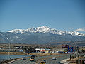
north of Pikes Peak
Pikes Peak
Pikes Peak is a mountain in the Front Range of the Rocky Mountains, west of Colorado Springs, Colorado, in El Paso County in the United States of America....
. Colorado City served as the county seat
County seat
A county seat is an administrative center, or seat of government, for a county or civil parish. The term is primarily used in the United States....
of El Paso County.
The Jefferson Territory never received federal sanction, but on 1861-02-28, U.S. President James Buchanan
James Buchanan
James Buchanan, Jr. was the 15th President of the United States . He is the only president from Pennsylvania, the only president who remained a lifelong bachelor and the last to be born in the 18th century....
signed an act organizing the Territory of Colorado. El Paso County was one of the original 17 counties created by the Colorado legislature on November 1, 1861. Part of its western territory was broken off to create Teller County
Teller County, Colorado
Teller County is the 22nd most populous of the 64 counties of the State of Colorado of the United States. The county population was 20,555 at U.S. Census 2000. The county seat is Cripple Creek, and the most populous city is Woodland Park...
in 1899. Originally based in Old Colorado City (now part of Colorado Springs, not today's Colorado City
Colorado City, Colorado
Colorado City is a census-designated place in Pueblo County, Colorado, United States. It is part of the Pueblo Metropolitan Statistical Area. The population was 2,193 at the 2010 census...
between Pueblo
Pueblo, Colorado
Pueblo is a Home Rule Municipality that is the county seat and the most populous city of Pueblo County, Colorado, United States. The population was 106,595 in 2010 census, making it the 246th most populous city in the United States....
and Walsenburg
Walsenburg, Colorado
The City of Walsenburg or Los Leones is a Statutory City that is the county seat and the most populous city of Huerfano County, Colorado, United States...
), El Paso County's county seat was moved to Colorado Springs in 1873.
Geography
According to the 2000 census, the county has a total area of 2129.56 square miles (5,515.5 km²), of which 2126.45 square miles (5,507.5 km²) (or 99.85%) is land and 3.11 square miles (8.1 km²) (or 0.15%) is water.Adjacent counties
- Douglas CountyDouglas County, ColoradoDouglas County is the eighth most populous of the 64 counties of the state of Colorado, in the United States. The county is located midway between Colorado's two largest cities: Denver and Colorado Springs...
- north - Elbert CountyElbert County, ColoradoElbert County is the 21st most populous of the 64 counties of the State of Colorado of the United States. The county population was 19,872 at U.S. Census 2000. The county seat is Kiowa...
- north and east - Lincoln CountyLincoln County, ColoradoLincoln County is the tenth most extensive of the 64 counties of the State of Colorado of the United States. The county population was 6,087 at U.S. Census 2000...
- east - Crowley CountyCrowley County, ColoradoCrowley County is one of the 64 counties of the State of Colorado of the United States. The county population was 5,518 at U.S. Census 2000. The county seat is Ordway.- History :...
- southeast - Pueblo CountyPueblo County, ColoradoPueblo County is the tenth most populous of the 64 counties of the state of Colorado of the United States. The county was named for the historic city of Pueblo which took its name from the Spanish language word meaning "town" or "village". The United States Census Bureau estimates that the...
- south - Fremont CountyFremont County, ColoradoFremont County is the thirteenth most populous of the 64 counties of the state of Colorado of the United States. The county is named for explorer and presidential candidate John C. Frémont. The county population was 46,824 at the 2010 census. The county seat is Cañon City. The Cañon City...
- west - Teller CountyTeller County, ColoradoTeller County is the 22nd most populous of the 64 counties of the State of Colorado of the United States. The county population was 20,555 at U.S. Census 2000. The county seat is Cripple Creek, and the most populous city is Woodland Park...
- west
Major highways
.svg.png) Interstate 25
Interstate 25 U.S. Highway 24
 U.S. Highway 85
 State Highway 83Colorado State Highway 83State Highway 83 is a state highway that runs from SH 21 interchange in north Colorado Springs to SH 2 at Leetsdale Dr. / Colorado Blvd. in Denver.-Route description:...
 State Highway 94Colorado State Highway 94State Highway 94 is an long east–west Colorado state highway that goes east beginning from US 24 just east of Colorado Springs and ending at U.S. Highway 40/U.S. Highway 287 in rural Cheyenne County west of Wild Horse. The highway serves Schriever Air Force Base and the towns of Ellicott,...
 State Highway 115Colorado State Highway 115State Highway 115 is a state highway that runs from US 50 interchange in northern Cañon City to Interstate 25/ Nevada Avenue in Colorado Springs.-Route description:...
Demographics
As of the censusCensus
A census is the procedure of systematically acquiring and recording information about the members of a given population. It is a regularly occurring and official count of a particular population. The term is used mostly in connection with national population and housing censuses; other common...
of 2000, there were 516,929 people, 192,409 households, and 133,916 families residing in the county. The population density
Population density
Population density is a measurement of population per unit area or unit volume. It is frequently applied to living organisms, and particularly to humans...
was 243 people per square mile (94/km²). There were 202,428 housing units at an average density of 95 per square mile (37/km²). The racial makeup of the county was 81.19% White
Race (United States Census)
Race and ethnicity in the United States Census, as defined by the Federal Office of Management and Budget and the United States Census Bureau, are self-identification data items in which residents choose the race or races with which they most closely identify, and indicate whether or not they are...
, 6.51% Black
Race (United States Census)
Race and ethnicity in the United States Census, as defined by the Federal Office of Management and Budget and the United States Census Bureau, are self-identification data items in which residents choose the race or races with which they most closely identify, and indicate whether or not they are...
or African American
Race (United States Census)
Race and ethnicity in the United States Census, as defined by the Federal Office of Management and Budget and the United States Census Bureau, are self-identification data items in which residents choose the race or races with which they most closely identify, and indicate whether or not they are...
, 0.91% Native American
Race (United States Census)
Race and ethnicity in the United States Census, as defined by the Federal Office of Management and Budget and the United States Census Bureau, are self-identification data items in which residents choose the race or races with which they most closely identify, and indicate whether or not they are...
, 2.53% Asian
Race (United States Census)
Race and ethnicity in the United States Census, as defined by the Federal Office of Management and Budget and the United States Census Bureau, are self-identification data items in which residents choose the race or races with which they most closely identify, and indicate whether or not they are...
, 0.24% Pacific Islander
Race (United States Census)
Race and ethnicity in the United States Census, as defined by the Federal Office of Management and Budget and the United States Census Bureau, are self-identification data items in which residents choose the race or races with which they most closely identify, and indicate whether or not they are...
, 4.70% from other races
Race (United States Census)
Race and ethnicity in the United States Census, as defined by the Federal Office of Management and Budget and the United States Census Bureau, are self-identification data items in which residents choose the race or races with which they most closely identify, and indicate whether or not they are...
, and 3.91% from two or more races. 11.30% of the population were Hispanic
Race (United States Census)
Race and ethnicity in the United States Census, as defined by the Federal Office of Management and Budget and the United States Census Bureau, are self-identification data items in which residents choose the race or races with which they most closely identify, and indicate whether or not they are...
or Latino
Race (United States Census)
Race and ethnicity in the United States Census, as defined by the Federal Office of Management and Budget and the United States Census Bureau, are self-identification data items in which residents choose the race or races with which they most closely identify, and indicate whether or not they are...
of any race.
There were 192,409 households out of which 36.70% had children under the age of 18 living with them, 55.60% were married couples
Marriage
Marriage is a social union or legal contract between people that creates kinship. It is an institution in which interpersonal relationships, usually intimate and sexual, are acknowledged in a variety of ways, depending on the culture or subculture in which it is found...
living together, 10.20% had a female householder with no husband present, and 30.40% were non-families. 23.90% of all households were made up of individuals and 6.10% had someone living alone who was 65 years of age or older. The average household size was 2.61 and the average family size was 3.11.
In the county the population was spread out with 27.60% under the age of 18, 10.50% from 18 to 24, 32.50% from 25 to 44, 20.70% from 45 to 64, and 8.70% who were 65 years of age or older. The median age was 33 years. For every 100 females there were 100.90 males. For every 100 females age 18 and over, there were 98.80 males.
The median income for a household in the county was $46,844, and the median income for a family was $53,995. Males had a median income of $35,940 versus $26,252 for females. The per capita income
Per capita income
Per capita income or income per person is a measure of mean income within an economic aggregate, such as a country or city. It is calculated by taking a measure of all sources of income in the aggregate and dividing it by the total population...
for the county was $22,005. About 5.70% of families and 8.00% of the population were below the poverty line, including 10.00% of those under age 18 and 6.90% of those age 65 or over.
Government
El Paso County is governed by a Board of County Commissioners. Its current members are Amy Lathen, Sallie Clark, Dennis Hisey, Darryl Glenn, and Peggy Littleton.El Paso County commissioners are expecting a projected $7.5 million shortfall in the 2008 budget.
The Colorado Department of Corrections has its headquarters in an unincorporated area in the county.
Cities and towns
- CalhanCalhan, ColoradoThe town of Calhan is a Statutory Town in El Paso County, Colorado, United States. Calhan straddles U.S. Route 24. The population was 896 at the 2000 census...
- Colorado SpringsColorado Springs, ColoradoColorado Springs is a Home Rule Municipality that is the county seat and most populous city of El Paso County, Colorado, United States. Colorado Springs is located in South-Central Colorado, in the southern portion of the state. It is situated on Fountain Creek and is located south of the Colorado...
- FountainFountain, ColoradoThe city of Fountain is a Home Rule Municipality located in El Paso County, Colorado, United States. Fountain is located just ten miles south of Colorado Springs and just east of Fort Carson. Fountain and the Colorado Springs suburbs Security and Widefield make up the "Fountain Valley" community....
- Green Mountain FallsGreen Mountain Falls, ColoradoGreen Mountain Falls is a Statutory Town in El Paso and Teller counties in the U.S. state of Colorado. The population was 773 at the 2000 census.-Geography:Green Mountain Falls is located at ....
- Manitou SpringsManitou Springs, ColoradoThe city of Manitou Springs is a Home Rule Municipality located in El Paso County, Colorado, United States. The population was 4,980 at the 2000 census.Students are served by Manitou Springs School District 14 and Manitou Springs High School....
- MonumentMonument, ColoradoMonument is a growing town situated on the Rampart Range in El Paso County, Colorado, United States. Monument is bordered by Pike National Forest on the west, Colorado Springs and the United States Air Force Academy to the south, foothills and rock outcroppings to the north and rolling plains to...
- Palmer LakePalmer Lake, ColoradoPalmer Lake is a Statutory Town in El Paso County, Colorado, United States. The population was 2,179 at the 2000 census. Palmer Lake was founded by General William Jackson Palmer in 1871. The town was soon incorporated in 1889....
- RamahRamah, ColoradoThe town of Ramah is a Statutory Town in El Paso County, Colorado, United States. The population was 220, as estimated in 2007.-Geography:Ramah is located at ....
Census-designated places and unincorporated areas
- Air Force AcademyAir Force Academy, ColoradoAir Force Academy is a census-designated place in El Paso County, Colorado, United States. The CDP includes a large portion of the grounds of the United States Air Force Academy, including the cadet housing facilities. The population was 6,680 at the 2010 census...
- Black ForestBlack Forest, ColoradoBlack Forest is a census-designated place near Colorado Springs, Colorado, United States. The population was 13,116 at the 2010 census. Black Forest is named such for the high density of Ponderosa Pines located in a generally small area...
- Cascade-Chipita ParkCascade-Chipita Park, ColoradoCascade-Chipita Park is a census-designated place in El Paso County, Colorado, United States. The population was 1,655 at the 2010 census.-Geography:Cascade-Chipita Park is located at ....
- Cimarron HillsCimarron Hills, ColoradoCimarron Hills is a census-designated place in El Paso County, Colorado, United States. The population was 16,161 at the 2010 census.-Geography:Cimarron Hills is located at ....
- EllicottEllicott, ColoradoEllicott is a census-designated place located in El Paso County, Colorado. The population as of the 2010 Census was 1,131.The U.S. Post Office at Calhan now serves the Ellicott postal address....
- FalconFalcon, ColoradoFalcon is an unincorporated exurb in El Paso County, Colorado, United States. It lies along US 24 about 14 miles northeast of Colorado Springs. A railroad hub in the early 20th century, the town spent several decades as a quiet ranching community until it experienced rapid residential growth...
- Fort CarsonFort Carson, ColoradoFort Carson is a United States Army installation located near Colorado Springs, primarily in El Paso County, Colorado. It is north of Pueblo, Colorado in Pueblo County. The 137,000 acre installation extends south into Pueblo and Fremont counties...
- GleneagleGleneagle, ColoradoGleneagle is a census-designated place located within El Paso County, Colorado, United States. The population was 6,611 at the 2010 census.-Geography:Gleneagle is located at ....
- PeytonPeyton, ColoradoPeyton is a census-designated place and a U.S. Post Office in El Paso County, Colorado, United States. The population as of the 2010 Census was 250. The nearby unincorporated area of Falcon also uses zip code 80831...
- Security-WidefieldSecurity-Widefield, ColoradoSecurity-Widefield is a census-designated place in El Paso County, Colorado, United States. The population was 29,845 at the 2000 census.-Geography:Security-Widefield is located at ....
- RushRush, ColoradoRush is an unincorporated town and a U.S. Post Office located in El Paso County, Colorado, United States. The Rush Post Office has the ZIP Code 80833.-Geography:...
- StratmoorStratmoor, ColoradoStratmoor is a census-designated place in El Paso County, Colorado, United States. The population was 6,650 at the 2000 census.-Geography:Stratmoor is located at ....
- TrucktonTruckton, ColoradoTruckton is an unincorporated community in El Paso County, Colorado, south of Colorado State Highway 94....
- WoodmoorWoodmoor, ColoradoWoodmoor is a census-designated place in El Paso County, Colorado, United States in the statutory town of Monument. The population was 7,177 at the 2000 census.-Geography:Woodmoor is located at ....
- YoderYoder, ColoradoYoder is an unincorporated town and a U.S. Post Office located in El Paso County, Colorado, United States. The Yoder Post Office has the ZIP Code 80864....
Military sites
- United States Air Force AcademyUnited States Air Force AcademyThe United States Air Force Academy is an accredited college for the undergraduate education of officer candidates for the United States Air Force. Its campus is located immediately north of Colorado Springs in El Paso County, Colorado, United States...
- Cheyenne MountainCheyenne MountainCheyenne Mountain is a mountain located just outside the southwest side of Colorado Springs, Colorado, U.S., and is home to the Cheyenne Mountain Air Force Station and its Cheyenne Mountain Directorate, formerly known as the Cheyenne Mountain Operations Center .Throughout the Cold War and...
- North American Aerospace Defense CommandNorth American Aerospace Defense CommandNorth American Aerospace Defense Command is a joint organization of Canada and the United States that provides aerospace warning, air sovereignty, and defense for the two countries. Headquarters NORAD is located at Peterson AFB, Colorado Springs, Colorado...
- Peterson Air Force BasePeterson Air Force BasePeterson Air Force Base is a base of the United States Air Force located at Colorado Springs in El Paso County, Colorado, United States and it provides runways for the adjacent City of Colorado Springs Municipal Airport under a shared joint civil-military airport arrangement...
- Schriever Air Force BaseSchriever Air Force BaseSchriever Air Force Base is a base of the United States Air Force located approximately 10 miles east of Peterson AFB near Colorado Springs in El Paso County, Colorado, United States.-Overview:...
- Fort Carson Army Base
National forest
- Pike National ForestPike National ForestThe Pike National Forest is located in the Front Range of Colorado, USA, west of Colorado Springs and including Pikes Peak. The forest encompasses 1,106,604 acres within Clear Creek, Teller, Park, Jefferson, Douglas and El Paso counties. The major rivers draining the forest are the South Platte...
Historic sites
- Pikes Peak National Historic Landmark
- USAFA Cadet Area National Historic DistrictUnited States Air Force AcademyThe United States Air Force Academy is an accredited college for the undergraduate education of officer candidates for the United States Air Force. Its campus is located immediately north of Colorado Springs in El Paso County, Colorado, United States...
Trails
- American Discovery TrailAmerican Discovery TrailThe American Discovery Trail is a coast-to-coast hiking and biking trail across the mid-tier of the United States. It starts on the Delmarva Peninsula on the Atlantic Ocean and ends on the northern California coast on the Pacific Ocean, and is signed on over of trail. This includes the doubled...
- Barr National Recreation Trail
- White House Ranch National Recreation Trail
See also
- El Paso County, Jefferson TerritoryEl Paso County, Jefferson TerritoryEl Paso County was a county of the extralegal United States Territory of Jefferson that existed from November 28, 1859, until February 28, 1861.-History:...
- Colorado census statistical areas
- Colorado metropolitan areasColorado metropolitan areasThe metropolitan areas of the State of Colorado include the urban statistical areas defined by the United States Office of Management and Budget and regions of urban population defined by other organizations.-Census statistical areas:...
- Colorado municipalitiesColorado municipalitiesThe U.S. state of Colorado currently has 271 active incorporated municipalities, including 196 towns, 73 cities, and two consolidated city and county governments.-Municipal government:...
- Front Range Urban CorridorFront Range Urban CorridorThe Front Range Urban Corridor is an oblong region of urban population located along the eastern face of the Southern Rocky Mountains in the U.S. states of Colorado and Wyoming. The corridor derives its name from the Front Range, the mountain range that defines the west central boundary of the...
- National Register of Historic Places listings in El Paso County, ColoradoNational Register of Historic Places listings in El Paso County, ColoradoThis is a list of the National Register of Historic Places listings in El Paso County, Colorado. It is intended to be a complete list of the properties and districts on the National Register of Historic Places in El Paso County, Colorado, United States...