
Eagle County, Colorado
Encyclopedia
Eagle County is the thirteenth most populous of the 64 counties
of the State of Colorado
in the United States
. The county is named for the Eagle River
. The county population was 41,659 at U.S. Census 2000. The county seat
is the Town of Eagle
. The Edwards Micropolitan Statistical Area
comprises Eagle County and Lake County
.
. It was named after the Eagle River
, which runs through the county. The county seat was originally set in Red Cliff
, Colorado
, but was moved to the town of Eagle in 1921.
 According to the 2010 census, the county has a total area of 1691.8 square miles (4,381.7 km²), of which 1687.88 square miles (4,371.6 km²) (or 99.77%) is land and 3.93 square miles (10.2 km²) (or 0.23%) is water.
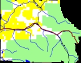
Much of the county is taken up by White River National Forest
, and much of the rest is managed by the Bureau of Land Management. Interstate 70
crosses the county from east to west.
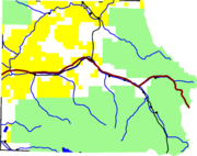
The Eagle River
rises in the southeastern part of the county. It receives Gore Creek
at Dowds Junction, and joins the Colorado River
in the west. Fryingpan River
and the Roaring Fork River
intersect the southwest corner of the county.
of 2000, there were 41,659 people, 15,148 households, and 9,013 families residing in the county. The population density
was 25 people per square mile (10/km²). There were 22,111 housing units at an average density of 13 per square mile (5/km²). The racial makeup of the county was 85.35% White
, 0.34% Black
or African American
, 0.71% Native American
, 0.82% Asian
, 0.07% Pacific Islander
, 10.80% from other races
, and 1.90% from two or more races. 23.24% of the population were Hispanic
or Latino
of any race.
There were 15,148 households out of which 32.70% had children under the age of 18 living with them, 50.00% were married couples
living together, 5.60% had a female householder with no husband present, and 40.50% were non-families. 20.90% of all households were made up of individuals and 1.90% had someone living alone who was 65 years of age or older. The average household size was 2.73 and the average family size was 3.17.
In the county the population was spread out with 23.50% under the age of 18, 11.40% from 18 to 24, 42.10% from 25 to 44, 20.00% from 45 to 64, and 3.00% who were 65 years of age or older. The median age was 31 years. For every 100 females there were 121.00 males. For every 100 females age 18 and over, there were 125.80 males.
The median income for a household in the county was $62,682, and the median income for a family was $68,226. Males had a median income of $37,603 versus $30,579 for females. The per capita income
for the county was $32,011. About 3.90% of families and 7.80% of the population were below the poverty line, including 6.80% of those under age 18 and 7.60% of those age 65 or over.
Colorado counties
The U.S state of Colorado is divided into 64 counties. Counties are important units of government in Colorado since the state has no secondary civil subdivisions, such as townships...
of the State of Colorado
Colorado
Colorado is a U.S. state that encompasses much of the Rocky Mountains as well as the northeastern portion of the Colorado Plateau and the western edge of the Great Plains...
in the United States
United States
The United States of America is a federal constitutional republic comprising fifty states and a federal district...
. The county is named for the Eagle River
Eagle River (Colorado)
The Eagle River is a tributary of the Colorado River, approximately long, in west central Colorado in the United States.It rises in southeastern Eagle County, at the continental divide, and flows northwest past Gilman, Minturn, Avon...
. The county population was 41,659 at U.S. Census 2000. The county seat
County seat
A county seat is an administrative center, or seat of government, for a county or civil parish. The term is primarily used in the United States....
is the Town of Eagle
Eagle, Colorado
Eagle is a Statutory Town in and the county seat of Eagle County, Colorado, United States. The population was 3,032 at the 2000 census.The town was made famous as the location of the Kobe Bryant sexual assault trial.-Demographics:...
. The Edwards Micropolitan Statistical Area
Edwards Micropolitan Statistical Area
The Edwards Micropolitan Statistical Area is a United States Census Bureau defined Micropolitan Statistical Area located in the Edwards area of the State of Colorado. The Edwards Micropolitan Statistical Area comprises Eagle County and Lake County, Colorado. The Micropolitan Statistical Area had...
comprises Eagle County and Lake County
Lake County, Colorado
Lake County is one of the 64 counties of the State of Colorado of the United States. The highest natural point in Colorado and the entire Rocky Mountains is the summit of Mount Elbert in Lake County at 14,440 feet elevation. The county population was 7,812 at U.S. Census 2000. The county seat...
.
History
Eagle County was created by the Colorado legislature on February 11, 1883, from portions of Summit CountySummit County, Colorado
Summit County is the 19th most populous of the 64 counties of the state of Colorado of the United States. The county population was 23,538 at U.S. Census 2000. The county seat is Breckenridge...
. It was named after the Eagle River
Eagle River (Colorado)
The Eagle River is a tributary of the Colorado River, approximately long, in west central Colorado in the United States.It rises in southeastern Eagle County, at the continental divide, and flows northwest past Gilman, Minturn, Avon...
, which runs through the county. The county seat was originally set in Red Cliff
Red Cliff, Colorado
Red Cliff is a Statutory Town in Eagle County, Colorado, United States. The population was 289 at the 2000 census. The town is a former mining camp situated in the canyon of the upper Eagle River just off U.S. Highway 24 north of Tennessee Pass...
, Colorado
Colorado
Colorado is a U.S. state that encompasses much of the Rocky Mountains as well as the northeastern portion of the Colorado Plateau and the western edge of the Great Plains...
, but was moved to the town of Eagle in 1921.
Geography
Much of the county is taken up by White River National Forest
White River National Forest
White River National Forest is a National Forest in northwest Colorado. It is named after the White River that passes through it. It also contains the Flat Tops Wilderness Area, largely considered the birthplace of the U.S...
, and much of the rest is managed by the Bureau of Land Management. Interstate 70
Interstate 70
Interstate 70 is an Interstate Highway in the United States that runs from Interstate 15 near Cove Fort, Utah, to a Park and Ride near Baltimore, Maryland. It was the first Interstate Highway project in the United States. I-70 approximately traces the path of U.S. Route 40 east of the Rocky...
crosses the county from east to west.
The Eagle River
Eagle River (Colorado)
The Eagle River is a tributary of the Colorado River, approximately long, in west central Colorado in the United States.It rises in southeastern Eagle County, at the continental divide, and flows northwest past Gilman, Minturn, Avon...
rises in the southeastern part of the county. It receives Gore Creek
Gore Creek (Colorado)
Gore Creek is a tributary of the Eagle River, approximately long, in Eagle County in central Colorado in the United States. It drains an area of the Rocky Mountains at the south end of the Gore Range through Vail Valley. It rises on the Eagle County-Summit County border along the high crest of the...
at Dowds Junction, and joins the Colorado River
Colorado River
The Colorado River , is a river in the Southwestern United States and northwestern Mexico, approximately long, draining a part of the arid regions on the western slope of the Rocky Mountains. The watershed of the Colorado River covers in parts of seven U.S. states and two Mexican states...
in the west. Fryingpan River
Fryingpan River
The Fryingpan River is a tributary of the Roaring Fork River, approximately long, in west central Colorado in the United States.It rises in northeastern Pitkin County, in the White River National Forest in the Sawatch Mountains along the western side of the continental divide. It flows westward...
and the Roaring Fork River
Roaring Fork River
Roaring Fork River is a tributary of the Colorado River, approximately long, in west central Colorado in the United States. The river drains a populated and economically vital area of the Colorado Western Slope called the Roaring Fork Valley or Roaring Fork Watershed, which includes the resort...
intersect the southwest corner of the county.
Adjacent counties
- Grand CountyGrand County, ColoradoGrand County is the 21st largest of the 64 counties of the State of Colorado of the United States. The county population was 12,442 at U.S. Census 2000...
- northeast - Summit CountySummit County, ColoradoSummit County is the 19th most populous of the 64 counties of the state of Colorado of the United States. The county population was 23,538 at U.S. Census 2000. The county seat is Breckenridge...
- east - Lake CountyLake County, ColoradoLake County is one of the 64 counties of the State of Colorado of the United States. The highest natural point in Colorado and the entire Rocky Mountains is the summit of Mount Elbert in Lake County at 14,440 feet elevation. The county population was 7,812 at U.S. Census 2000. The county seat...
- south - Pitkin CountyPitkin County, ColoradoPitkin County is one of the 64 counties of the State of Colorado of the United States. The county is named in honor of the late Colorado Governor Frederick Walker Pitkin. The county population was 14,872 at U.S. Census 2000. The county seat is Aspen...
- southwest - Garfield CountyGarfield County, ColoradoGarfield County is the eighth most extensive and the twelfth most populous of the 64 counties of the State of Colorado of the United States. The county population was 43,791 at U.S. Census 2000. The county is named in honor of United States President James A. Garfield...
- west - Routt CountyRoutt County, ColoradoRoutt County is the 15th most extensive of the 64 counties of the state of Colorado of the United States. The county population was 19,690 at U.S. Census 2000. The county seat is Steamboat Springs.- History :...
- northwest
Demographics
As of the censusCensus
A census is the procedure of systematically acquiring and recording information about the members of a given population. It is a regularly occurring and official count of a particular population. The term is used mostly in connection with national population and housing censuses; other common...
of 2000, there were 41,659 people, 15,148 households, and 9,013 families residing in the county. The population density
Population density
Population density is a measurement of population per unit area or unit volume. It is frequently applied to living organisms, and particularly to humans...
was 25 people per square mile (10/km²). There were 22,111 housing units at an average density of 13 per square mile (5/km²). The racial makeup of the county was 85.35% White
Race (United States Census)
Race and ethnicity in the United States Census, as defined by the Federal Office of Management and Budget and the United States Census Bureau, are self-identification data items in which residents choose the race or races with which they most closely identify, and indicate whether or not they are...
, 0.34% Black
Race (United States Census)
Race and ethnicity in the United States Census, as defined by the Federal Office of Management and Budget and the United States Census Bureau, are self-identification data items in which residents choose the race or races with which they most closely identify, and indicate whether or not they are...
or African American
Race (United States Census)
Race and ethnicity in the United States Census, as defined by the Federal Office of Management and Budget and the United States Census Bureau, are self-identification data items in which residents choose the race or races with which they most closely identify, and indicate whether or not they are...
, 0.71% Native American
Race (United States Census)
Race and ethnicity in the United States Census, as defined by the Federal Office of Management and Budget and the United States Census Bureau, are self-identification data items in which residents choose the race or races with which they most closely identify, and indicate whether or not they are...
, 0.82% Asian
Race (United States Census)
Race and ethnicity in the United States Census, as defined by the Federal Office of Management and Budget and the United States Census Bureau, are self-identification data items in which residents choose the race or races with which they most closely identify, and indicate whether or not they are...
, 0.07% Pacific Islander
Race (United States Census)
Race and ethnicity in the United States Census, as defined by the Federal Office of Management and Budget and the United States Census Bureau, are self-identification data items in which residents choose the race or races with which they most closely identify, and indicate whether or not they are...
, 10.80% from other races
Race (United States Census)
Race and ethnicity in the United States Census, as defined by the Federal Office of Management and Budget and the United States Census Bureau, are self-identification data items in which residents choose the race or races with which they most closely identify, and indicate whether or not they are...
, and 1.90% from two or more races. 23.24% of the population were Hispanic
Race (United States Census)
Race and ethnicity in the United States Census, as defined by the Federal Office of Management and Budget and the United States Census Bureau, are self-identification data items in which residents choose the race or races with which they most closely identify, and indicate whether or not they are...
or Latino
Race (United States Census)
Race and ethnicity in the United States Census, as defined by the Federal Office of Management and Budget and the United States Census Bureau, are self-identification data items in which residents choose the race or races with which they most closely identify, and indicate whether or not they are...
of any race.
There were 15,148 households out of which 32.70% had children under the age of 18 living with them, 50.00% were married couples
Marriage
Marriage is a social union or legal contract between people that creates kinship. It is an institution in which interpersonal relationships, usually intimate and sexual, are acknowledged in a variety of ways, depending on the culture or subculture in which it is found...
living together, 5.60% had a female householder with no husband present, and 40.50% were non-families. 20.90% of all households were made up of individuals and 1.90% had someone living alone who was 65 years of age or older. The average household size was 2.73 and the average family size was 3.17.
In the county the population was spread out with 23.50% under the age of 18, 11.40% from 18 to 24, 42.10% from 25 to 44, 20.00% from 45 to 64, and 3.00% who were 65 years of age or older. The median age was 31 years. For every 100 females there were 121.00 males. For every 100 females age 18 and over, there were 125.80 males.
The median income for a household in the county was $62,682, and the median income for a family was $68,226. Males had a median income of $37,603 versus $30,579 for females. The per capita income
Per capita income
Per capita income or income per person is a measure of mean income within an economic aggregate, such as a country or city. It is calculated by taking a measure of all sources of income in the aggregate and dividing it by the total population...
for the county was $32,011. About 3.90% of families and 7.80% of the population were below the poverty line, including 6.80% of those under age 18 and 7.60% of those age 65 or over.
Cities and towns
- AvonAvon, ColoradoAvon is a Home Rule Municipality that is the most populous town in Eagle County, Colorado, United States. The population was 5,561 at the 2000 census. Avon is the gateway to the Beaver Creek Resort which lies about two miles south of the town. It was the previous site of Vail Resorts before the...
- BasaltBasalt, ColoradoBasalt is a Statutory Town in Eagle and Pitkin counties in the U.S. state of Colorado. The population was 2,681 at the 2000 census.-Geography:...
- EagleEagle, ColoradoEagle is a Statutory Town in and the county seat of Eagle County, Colorado, United States. The population was 3,032 at the 2000 census.The town was made famous as the location of the Kobe Bryant sexual assault trial.-Demographics:...
- Eagle-VailEagle-Vail, ColoradoEagle-Vail is a former census-designated place in Eagle County, Colorado, United States, along Interstate 70 and the Eagle River. The population was 2,887 at the 2000 census. The area was not returned separately by census enumerators in 2010....
- EdwardsEdwards, ColoradoEdwards is a census-designated place in Eagle County, Colorado, United States. Edwards is the principal community of the Edwards Micropolitan Statistical Area. The population was 10,266 at the 2010 census...
- El JebelEl Jebel, ColoradoEl Jebel is a census-designated place in Eagle County, Colorado, United States. The population was 3,801 at the 2010 census. The community is located in the Roaring Fork Valley, between Carbondale and Basalt, along the north side of State Highway 82...
- GypsumGypsum, ColoradoThe Town of Gypsum is a Home Rule Municipality located in Eagle County, Colorado, United States. The population was 3,654 at the 2000 census. Gypsum is the location of the Eagle County Regional Airport , a popular regional airport used in the winter to transport skiers to nearby Vail...
- MinturnMinturn, ColoradoMinturn is a Home Rule Municipality in Eagle County, Colorado, United States. The population was 1,068 at the 2000 census.-Geography:Minturn is located at ....
- Red CliffRed Cliff, ColoradoRed Cliff is a Statutory Town in Eagle County, Colorado, United States. The population was 289 at the 2000 census. The town is a former mining camp situated in the canyon of the upper Eagle River just off U.S. Highway 24 north of Tennessee Pass...
- VailVail, ColoradoThe Town of Vail is a Home Rule Municipality in Eagle County, Colorado, United States. The population of the town was 4,589 in 2005. The town was established and built as the base village to Vail Ski Resort, with which it was originally conceived...
- GilmanGilman, ColoradoGilman is an abandoned mining town in southeastern Eagle County, Colorado, United States. The U.S. Post Office at Minturn now serves Gilman postal addresses....
(abandoned in 1984)
National forest and wilderness
- White River National ForestWhite River National ForestWhite River National Forest is a National Forest in northwest Colorado. It is named after the White River that passes through it. It also contains the Flat Tops Wilderness Area, largely considered the birthplace of the U.S...
- Eagles Nest WildernessEagles Nest WildernessThe Eagles Nest Wilderness is a U.S. Wilderness Area located in the Gore Range near Vail, Copper Mountain, Frisco, Silverthorne, and Heeney, in Summit and Eagle Counties Colorado. Eagles Nest Wilderness falls within the jurisdiction of Dillon Ranger District and Holy Cross Ranger District, White...
- Flat Tops Wilderness
- Holy Cross WildernessHoly Cross WildernessThe Holy Cross Wilderness is a U.S. Wilderness Area located in San Isabel and White River national forests near Leadville, Minturn, Avon, Edwards, Eagle, and Vail, Colorado. The wilderness with of trails was established in 1980. The wilderness was named after its highest peak, Mount of the...
Trails
- Colorado TrailColorado TrailThe Colorado Trail is a long trail running from the mouth of Waterton Canyon southwest of Denver to Durango in Colorado, United States. Its highest point is above sea level, and most of the trail is above...
- Continental Divide National Scenic Trail
- Two Elk National Recreation Trail
- Vail Pass National Recreation Trail
Scenic byways
- Colorado River Headwaters National Scenic Byway
- Top of the Rockies National Scenic Byway
See also
- Colorado census statistical areas
- Colorado countiesColorado countiesThe U.S state of Colorado is divided into 64 counties. Counties are important units of government in Colorado since the state has no secondary civil subdivisions, such as townships...
- Colorado municipalitiesColorado municipalitiesThe U.S. state of Colorado currently has 271 active incorporated municipalities, including 196 towns, 73 cities, and two consolidated city and county governments.-Municipal government:...
- Edwards Micropolitan Statistical AreaEdwards Micropolitan Statistical AreaThe Edwards Micropolitan Statistical Area is a United States Census Bureau defined Micropolitan Statistical Area located in the Edwards area of the State of Colorado. The Edwards Micropolitan Statistical Area comprises Eagle County and Lake County, Colorado. The Micropolitan Statistical Area had...
- Flight of Craig D. Button
- National Register of Historic Places listings in Eagle County, ColoradoNational Register of Historic Places listings in Eagle County, ColoradoThis is a list of the National Register of Historic Places listings in Eagle County, Colorado. It is intended to be a complete list of the properties and districts on the National Register of Historic Places in Eagle County, Colorado, United States...