
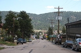
Woodland Park, Colorado
Encyclopedia
The City of Woodland Park is a Home Rule Municipality that is the most populous city in Teller County
, Colorado
, United States
and is immediately west of El Paso County
and the unincorporated community of Crystola
. Many residents in this bedroom community, which is surrounded by the one-million acre (4,000 km²) Pike National Forest
, make the 17 miles (27.4 km) commute to Colorado Springs
. Ute Pass
lies 12 miles (19.3 km) to the west of Woodland Park on US 24. The population was 6,515 at the 2000 census
. Nearby Douglas County
is about a fifteen-minute drive from the city.
Called the "The City Above the Clouds," Woodland Park, at 8465 feet (2,580.1 m) above sea level, often enjoys clear skies while weather in neighboring towns may be rainy or overcast. The city has pursued a policy of careful growth, and enjoys breathtaking views of Pikes Peak. Woodland Park offers easy access to hiking, climbing, and fishing. Because of the city's location, there is a natural limitation to population growth.
. (The highways overlap west to Divide
.)
According to the United States Census Bureau
, the city has a total area of 5.7 square miles (14.8 km²), all of it land.
of 2000, there were 6,515 people, 2,476 households, and 1,884 families residing in the city. The population density
was 1,151.0 people per square mile (444.4/km²). There were 2,642 housing units at an average density of 466.8 per square mile (180.2/km²). The racial makeup of the city was 94.89% White, 0.52% African American, 0.72% Native American, 0.87% Asian, 0.81% from other races
, and 2.18% from two or more races. Hispanic or Latino of any race were 3.45% of the population.
There were 2,476 households out of which 39.9% had children under the age of 18 living with them, 65.3% were married couples
living together, 7.7% had a female householder with no husband present, and 23.9% were non-families. 19.1% of all households were made up of individuals and 4.3% had someone living alone who was 65 years of age or older. The average household size was 2.63 and the average family size was 3.03.
In the city the population was spread out with 28.5% under the age of 18, 5.8% from 18 to 24, 32.9% from 25 to 44, 26.3% from 45 to 64, and 6.5% who were 65 years of age or older. The median age was 38 years. For every 100 females there were 100.4 males. For every 100 females age 18 and over, there were 97.0 males.
The median income for a household in the city was $52,279, and the median income for a family was $59,583. Males had a median income of $36,157 versus $27,459 for females. The per capita income
for the city was $22,780. About 1.8% of families and 3.7% of the population were below the poverty line, including 4.9% of those under age 18 and 3.7% of those age 65 or over.
Students are served by Woodland Park School District RE-2.
A number of full-time musicians reside in Woodland Park and the surrounding areas, and arts festivals have become more frequent in recent years, often held at the Ute Pass Cultural Center. Woodland Park is also the site of the Rocky Mountain Dinosaur Resource Center, a museum devoted to dinosaurs and fossils.
Teller County, Colorado
Teller County is the 22nd most populous of the 64 counties of the State of Colorado of the United States. The county population was 20,555 at U.S. Census 2000. The county seat is Cripple Creek, and the most populous city is Woodland Park...
, Colorado
Colorado
Colorado is a U.S. state that encompasses much of the Rocky Mountains as well as the northeastern portion of the Colorado Plateau and the western edge of the Great Plains...
, United States
United States
The United States of America is a federal constitutional republic comprising fifty states and a federal district...
and is immediately west of El Paso County
El Paso County, Colorado
El Paso County is the most populous of the 64 counties of the state of Colorado of the United States, now more populous than Denver County. The United States Census Bureau concluded that the county population was 622,371 in 2010. In recent years, the population had come closer to that of Denver...
and the unincorporated community of Crystola
Crystola, Colorado
Crystola is an unincorporated town in Teller County, Colorado, United States. ZIP code 80863 serves Crystola, but mail must be addressed to Woodland Park.-Geography:Crystola is located at ....
. Many residents in this bedroom community, which is surrounded by the one-million acre (4,000 km²) Pike National Forest
Pike National Forest
The Pike National Forest is located in the Front Range of Colorado, USA, west of Colorado Springs and including Pikes Peak. The forest encompasses 1,106,604 acres within Clear Creek, Teller, Park, Jefferson, Douglas and El Paso counties. The major rivers draining the forest are the South Platte...
, make the 17 miles (27.4 km) commute to Colorado Springs
Colorado Springs, Colorado
Colorado Springs is a Home Rule Municipality that is the county seat and most populous city of El Paso County, Colorado, United States. Colorado Springs is located in South-Central Colorado, in the southern portion of the state. It is situated on Fountain Creek and is located south of the Colorado...
. Ute Pass
Ute Pass
Ute Pass is a mountain pass west of Colorado Springs, near Divide.The climate is arid, so many plants that grow here are adapted to low water usage. The pass at one time was used by stage coach and equestrian traffic. It is steep on the east side. The pass is traversed by U.S. Highway 24....
lies 12 miles (19.3 km) to the west of Woodland Park on US 24. The population was 6,515 at the 2000 census
United States Census, 2000
The Twenty-second United States Census, known as Census 2000 and conducted by the Census Bureau, determined the resident population of the United States on April 1, 2000, to be 281,421,906, an increase of 13.2% over the 248,709,873 persons enumerated during the 1990 Census...
. Nearby Douglas County
Douglas County, Colorado
Douglas County is the eighth most populous of the 64 counties of the state of Colorado, in the United States. The county is located midway between Colorado's two largest cities: Denver and Colorado Springs...
is about a fifteen-minute drive from the city.
Called the "The City Above the Clouds," Woodland Park, at 8465 feet (2,580.1 m) above sea level, often enjoys clear skies while weather in neighboring towns may be rainy or overcast. The city has pursued a policy of careful growth, and enjoys breathtaking views of Pikes Peak. Woodland Park offers easy access to hiking, climbing, and fishing. Because of the city's location, there is a natural limitation to population growth.
Geography
Woodland Park is located at 38°59′54"N 105°3′23"W (38.998226, -105.056269), at the eastern intersection of U.S. Highway 24 and State Highway 67Colorado State Highway 67
State Highway 67 is a long state highway encompassing five distinct segments in south-central Colorado. The route runs north from Wetmore to Sedalia, Colorado, traversing the former route of the Florence and Cripple Creek Railroad through Phantom Canyon as a county road and carrying part of the...
. (The highways overlap west to Divide
Divide, Colorado
Divide is a census-designated place and a U.S. Post Office in Teller County, Colorado, United States. The population as of the 2010 Census was 127....
.)
According to the United States Census Bureau
United States Census Bureau
The United States Census Bureau is the government agency that is responsible for the United States Census. It also gathers other national demographic and economic data...
, the city has a total area of 5.7 square miles (14.8 km²), all of it land.
Demographics
As of the censusCensus
A census is the procedure of systematically acquiring and recording information about the members of a given population. It is a regularly occurring and official count of a particular population. The term is used mostly in connection with national population and housing censuses; other common...
of 2000, there were 6,515 people, 2,476 households, and 1,884 families residing in the city. The population density
Population density
Population density is a measurement of population per unit area or unit volume. It is frequently applied to living organisms, and particularly to humans...
was 1,151.0 people per square mile (444.4/km²). There were 2,642 housing units at an average density of 466.8 per square mile (180.2/km²). The racial makeup of the city was 94.89% White, 0.52% African American, 0.72% Native American, 0.87% Asian, 0.81% from other races
Race (United States Census)
Race and ethnicity in the United States Census, as defined by the Federal Office of Management and Budget and the United States Census Bureau, are self-identification data items in which residents choose the race or races with which they most closely identify, and indicate whether or not they are...
, and 2.18% from two or more races. Hispanic or Latino of any race were 3.45% of the population.
There were 2,476 households out of which 39.9% had children under the age of 18 living with them, 65.3% were married couples
Marriage
Marriage is a social union or legal contract between people that creates kinship. It is an institution in which interpersonal relationships, usually intimate and sexual, are acknowledged in a variety of ways, depending on the culture or subculture in which it is found...
living together, 7.7% had a female householder with no husband present, and 23.9% were non-families. 19.1% of all households were made up of individuals and 4.3% had someone living alone who was 65 years of age or older. The average household size was 2.63 and the average family size was 3.03.
In the city the population was spread out with 28.5% under the age of 18, 5.8% from 18 to 24, 32.9% from 25 to 44, 26.3% from 45 to 64, and 6.5% who were 65 years of age or older. The median age was 38 years. For every 100 females there were 100.4 males. For every 100 females age 18 and over, there were 97.0 males.
The median income for a household in the city was $52,279, and the median income for a family was $59,583. Males had a median income of $36,157 versus $27,459 for females. The per capita income
Per capita income
Per capita income or income per person is a measure of mean income within an economic aggregate, such as a country or city. It is calculated by taking a measure of all sources of income in the aggregate and dividing it by the total population...
for the city was $22,780. About 1.8% of families and 3.7% of the population were below the poverty line, including 4.9% of those under age 18 and 3.7% of those age 65 or over.
Students are served by Woodland Park School District RE-2.
Local notes
At roughly 8500 feet (2,590.8 m), Woodland Park is just beginning to recover from a long drought; the winter of 2006-2007 marked the return of what long-time residents have called "real Woodland Park weather" with daytime winter temperatures frequently plunging below freezing. However, some residents find Colorado winters more tolerable than those in other parts of the country, with blue skies and warm days peppered throughout the season.A number of full-time musicians reside in Woodland Park and the surrounding areas, and arts festivals have become more frequent in recent years, often held at the Ute Pass Cultural Center. Woodland Park is also the site of the Rocky Mountain Dinosaur Resource Center, a museum devoted to dinosaurs and fossils.
Notable residents
- John McAfeeJohn McAfeeJohn McAfee is a computer programmer and founder of McAfee. He was one of the first people to design anti-virus software and to develop a virus scanner. He was born in England and raised in Salem, Virginia...
, founder of McAfee, Inc.McAfeeMcAfee, Inc. is a computer security company headquartered in Santa Clara, California, USA. It markets software and services to home users, businesses and the public sector. On August 19, 2010, electronics company Intel agreed to purchase McAfee for $7.68 billion... - Robert L. StewartRobert L. StewartRobert Lee Stewart is a retired Brigadier General of the United States Army and former NASA astronaut.-Personal:Stewart was born August 13, 1942, in Washington, D.C.. He graduated from Hattiesburg High School, Hattiesburg, Mississippi, in 1960...
(Brigadier General, USA, Ret.) - former NASA astronautAstronautAn astronaut or cosmonaut is a person trained by a human spaceflight program to command, pilot, or serve as a crew member of a spacecraft.... - Clint VahsholtzClint VahsholtzClint Vahsholtz, from Woodland Park, CO, is a former NASCAR driver. He competed in the Busch Series in 2003 and 2004.-Nascar West:Vahsholtz made seven career starts in this lower level division of NASCAR. His best outing came in 2003, when his race at Phoeinx, which was a 10th place finish...
- ARCA driver
See also
- Colorado municipalitiesColorado municipalitiesThe U.S. state of Colorado currently has 271 active incorporated municipalities, including 196 towns, 73 cities, and two consolidated city and county governments.-Municipal government:...
- Colorado Springs Metropolitan Statistical AreaColorado Springs Metropolitan Statistical AreaThe Colorado Springs Metropolitan Statistical Area is a United States Census Bureau defined Metropolitan Statistical Area located in the Colorado Springs region of the State of Colorado. The Census Bureau estimates that the population was 647,758 in 2010, a 20.48% increase since 2000. The...
- Front Range Urban CorridorFront Range Urban CorridorThe Front Range Urban Corridor is an oblong region of urban population located along the eastern face of the Southern Rocky Mountains in the U.S. states of Colorado and Wyoming. The corridor derives its name from the Front Range, the mountain range that defines the west central boundary of the...
- South Central Colorado Urban AreaSouth Central Colorado Urban Areathumb|240px|An enlargeable map of the four-county South Central Colorado Urban AreaThe South Central Colorado Urban Area comprises the Colorado Springs Metropolitan Statistical Area, the Pueblo Metropolitan Statistical Area, and the Cañon City Micropolitan Statistical Area in the central and south...
- State of Colorado
- Teller County, ColoradoTeller County, ColoradoTeller County is the 22nd most populous of the 64 counties of the State of Colorado of the United States. The county population was 20,555 at U.S. Census 2000. The county seat is Cripple Creek, and the most populous city is Woodland Park...
- Woodland Park High SchoolWoodland Park High SchoolWoodland Park High School is a high school located at 151 North Baldwin Street in Woodland Park, Colorado.-History:The original Woodland Park School, built in 1890, was a two-story, white frame building with two teachers. The school was built on a plot of land behind the current location of the...