
.gif)
Tropical Storm Leslie (2000)
Encyclopedia
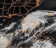
Tropical Storm Leslie was a weak, short-lived tropical cyclone
that was never well-organized; however, its precursor was costlier than any other tropical cyclone in the 2000 Atlantic hurricane season
. The twelfth named storm of the season, Leslie formed on October 4 over eastern Florida
as a subtropical cyclone
, out of a trough
of low pressure. Strengthening over open waters, it attained enough tropical characteristics
to be reclassified as Tropical Storm Leslie on October 5. The storm reached peak winds of 45 mph (75 km/h) before wind shear
weakened it, and on October 7 transitioned into an extratropical cyclone
over the open Atlantic Ocean
. Leslie lasted three more days before losing its identity.
The precursor to Leslie produced torrential rainfall across Florida, peaking at 17.5 in (440 mm). The flooding damaged thousands of houses and caused three indirect deaths. Damage in southern Florida totaled $950 million (2000 USD, $ USD), around half of which was from agricultural damage. After the flooding, portions of south Florida were declared a disaster area. Because of the limited impact as a tropical cyclone, the name Leslie was not retired in the Spring of 2001.
entered the eastern Caribbean Sea
, believed to be the same that spawned Hurricane Isaac
. It moved generally westward, and remained weak with sporadic thunderstorm activity. The wave traversed around the periphery of Hurricane Keith
, and by October 2, the system produced a mid-level circulation just south of western Cuba
. It continued to organize, prompting a reconnaissance aircraft
to investigate the area. The system lacked a surface circulation center and remained an elongated trough
of low pressure. The tropical wave interacted with an approaching frontal trough, while its mid-level center turned to the northeast and made landfall near Sarasota, Florida
on October 4.
While over land, a surface circulation developed near Orlando
, and the National Hurricane Center
designated the system as Subtropical Depression
One. The subtropical designation was because the convection was far-removed from the center. Additionally, an upper-level trough provided outflow
, instead of an anticyclone
as found in tropical cyclones. The subtropical depression moved to the east-northeast, and steadily organized as deep convection developed closer to the center. Initially, the strongest winds were 175 mi (280 km) from the center, but by the morning of October 5, the distance decreased to 85 mi (135 km). Based on its organization and winds of 40 mph (65 km/h), the system was re-designated as Tropical Storm Leslie.
 The National Hurricane Center initially forecast further intensification to 60 mph (95 km/h), although the agency also noted the that the circulation could dissipate, due its fast forward motion toward the east-northeast. Ultimately, wind shear
prohibited significant strengthening, and Leslie attained peak winds of 45 mph (70 km/h). The storm interacted with an approaching cold front
and became extratropical
on October 7, 375 mi (600 km) north of Bermuda
. It accelerated to the northeast and passed over Newfoundland on October 8. The remnants of Leslie turned to the east, then southeast, strengthening to near-hurricane force winds before losing its identity near Ireland
on October 10.
predicted the trough of low pressure to drop very heavy rainfall across western Cuba
and Florida
. The National Weather Service in Miami
issued a flood watch for southern Florida, stating that the system could produce flooding on roads and in low-lying areas. As a preemptive measure, water managers moved water out of canals. In general, however, there was little warning for the flooding in Florida. While Leslie was moving east-northeastward, it posed a threat to Bermuda
, prompting officials to issue a tropical storm warning
. However, the storm passed well to the west, and the warnings were quickly dropped.
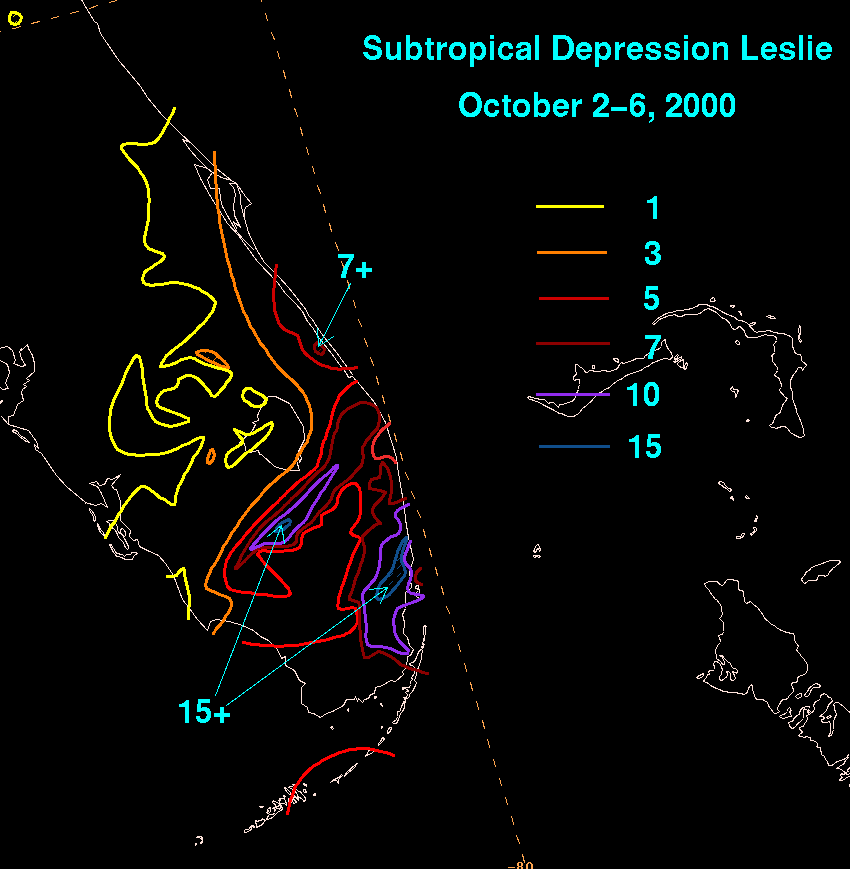 The precursor disturbance of Leslie dropped heavy rainfall across central and western Cuba
, peaking at 8.25 in (210 mm) in the province of Havana
. Numerous other areas reported over four in (100 mm), as well. In southern Florida
, the disturbance produced torrential rainfall, with a maximum of 17.5 in (440 mm) in South Miami
. Two areas, one to the south of Lake Okeechobee
and the other being the Miami area, received over 10 in (255 mm) of rain. The torrential rainfall was described as similar to Hurricane Irene
one year prior. The system produced two weak F0
tornadoes in Miami-Dade County
, one of which tore off a roof of a fire station in Hialeah
.
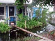
The torrential rainfall in Florida flooded about 93,000 homes, affecting 214,000 residents in Miami-Dade County. An incomplete damage survey of Miami-Dade County indicated the flooding destroyed 1,005 houses, severely damaged 1,358, and caused minor damage to 3,443. The flood waters, which were four ft (1.2 m) deep in places, stranded many in their houses, forcing them to use canoes or inflatable rafts to move to higher grounds. All schools in the Miami area were closed, and all non-essential Miami-Dade County employees were asked to stay home. Numerous flights in Miami International Airport
were canceled or delayed, although the airport remained opened. The flooding, which was greatest in Sweetwater, West Miami
, Hialeah
, Opa-Locka
, and Pembroke Park
, lasted up to a week in areas. The extreme flooding damaged electrical stations, leaving more than 27,000 without power. The flooding indirectly killed three people, two from drowning as a result of driving vehicles into deep water, and one when a man fell from a tall building while trying to unclog a roof drain. Property damage totaled $450 million (2000 USD, $ USD).
 Flood waters in Miami-Dade County
covered about 40,000 acres (160 km²) of farmland. The damage was worsened since the flooding occurred at the beginning of the planting period for the winter season. Flooded nurseries and fields resulted in about $500 million (2000 USD, $ USD) in agricultural damage, including $60 million (2000 USD, $ USD) in tropical fruit and $397 million (2000 USD, $ USD) in ornamental crops. The U.S. Department of Agriculture
declared 16 Florida counties, including Miami-Dade, Collier
, and Palm Beach
, as primary disaster areas due to flooding, making farmers and their families there eligible for USDA emergency farm loans. The same agency made 22 other counties, including Broward
, eligible for loans due to their proximity to the disaster areas.
As an extratropical storm, Leslie produced winds of around 40 mph (65 km/h) while making landfall in Newfoundland. It also caused waves of up to 16 ft (five m) in height, and brought up to one in (30 mm) of rain. The overall impact in this region was minor.
Bill Clinton
declared Broward
, Collier
, Miami-Dade
, and Monroe Counties
as disaster areas, allowing for the use of federal funds for the disaster victims. In addition, Miami-Dade and Broward Counties were declared eligible for Federal Infrastructure Assistance, which provided for 75% of the debris removal cost and the repairing or replacement of public roads, buildings, parks, and treatment plants. By ten days after the storm, government agencies distributed 105,000 meals, 141000 US gal (533,743.1 l) of water, and 357,000 lb (162,000 kg) of ice. Thousands visited the five Disaster Recovery Centers, where information on disaster-related issues was given. By around two months after the flooding, over 51,000 people applied for federal aid, with assistance totaling to more than $170 million (2000 USD, $ USD).
Tropical cyclone
A tropical cyclone is a storm system characterized by a large low-pressure center and numerous thunderstorms that produce strong winds and heavy rain. Tropical cyclones strengthen when water evaporated from the ocean is released as the saturated air rises, resulting in condensation of water vapor...
that was never well-organized; however, its precursor was costlier than any other tropical cyclone in the 2000 Atlantic hurricane season
2000 Atlantic hurricane season
The 2000 Atlantic hurricane season was the first season without a tropical cyclone in July since 1987. The season officially began on June 1, 2000, and lasted until November 30, 2000. The June through November dates conventionally delimit the period of each year when most tropical cyclones form in...
. The twelfth named storm of the season, Leslie formed on October 4 over eastern Florida
Florida
Florida is a state in the southeastern United States, located on the nation's Atlantic and Gulf coasts. It is bordered to the west by the Gulf of Mexico, to the north by Alabama and Georgia and to the east by the Atlantic Ocean. With a population of 18,801,310 as measured by the 2010 census, it...
as a subtropical cyclone
Subtropical cyclone
A subtropical cyclone is a weather system that has some characteristics of a tropical and an extratropical cyclone. As early as the 1950s, meteorologists were unclear whether they should be characterized as tropical or extratropical cyclones. They were officially recognized by the National...
, out of a trough
Trough (meteorology)
A trough is an elongated region of relatively low atmospheric pressure, often associated with fronts.Unlike fronts, there is not a universal symbol for a trough on a weather chart. The weather charts in some countries or regions mark troughs by a line. In the United States, a trough may be marked...
of low pressure. Strengthening over open waters, it attained enough tropical characteristics
Tropical cyclogenesis
Tropical cyclogenesis is the term that describes the development and strengthening of a tropical cyclone in the atmosphere. The mechanisms through which tropical cyclogenesis occurs are distinctly different from those through which mid-latitude cyclogenesis occurs...
to be reclassified as Tropical Storm Leslie on October 5. The storm reached peak winds of 45 mph (75 km/h) before wind shear
Wind shear
Wind shear, sometimes referred to as windshear or wind gradient, is a difference in wind speed and direction over a relatively short distance in the atmosphere...
weakened it, and on October 7 transitioned into an extratropical cyclone
Extratropical cyclone
Extratropical cyclones, sometimes called mid-latitude cyclones or wave cyclones, are a group of cyclones defined as synoptic scale low pressure weather systems that occur in the middle latitudes of the Earth having neither tropical nor polar characteristics, and are connected with fronts and...
over the open Atlantic Ocean
Atlantic Ocean
The Atlantic Ocean is the second-largest of the world's oceanic divisions. With a total area of about , it covers approximately 20% of the Earth's surface and about 26% of its water surface area...
. Leslie lasted three more days before losing its identity.
The precursor to Leslie produced torrential rainfall across Florida, peaking at 17.5 in (440 mm). The flooding damaged thousands of houses and caused three indirect deaths. Damage in southern Florida totaled $950 million (2000 USD, $ USD), around half of which was from agricultural damage. After the flooding, portions of south Florida were declared a disaster area. Because of the limited impact as a tropical cyclone, the name Leslie was not retired in the Spring of 2001.
Meteorological history
On September 27, a tropical waveTropical wave
Tropical waves, easterly waves, or tropical easterly waves, also known as African easterly waves in the Atlantic region, are a type of atmospheric trough, an elongated area of relatively low air pressure, oriented north to south, which move from east to west across the tropics causing areas of...
entered the eastern Caribbean Sea
Caribbean Sea
The Caribbean Sea is a sea of the Atlantic Ocean located in the tropics of the Western hemisphere. It is bounded by Mexico and Central America to the west and southwest, to the north by the Greater Antilles, and to the east by the Lesser Antilles....
, believed to be the same that spawned Hurricane Isaac
Hurricane Isaac (2000)
Hurricane Isaac was a tropical cyclone which was tied for the strongest tropical cyclone of the 2000 Atlantic hurricane season. The thirteenth tropical cyclone, ninth named storm, and the fifth hurricane of the season, Isaac developed from a tropical wave south of Cape Verde on September 21. On...
. It moved generally westward, and remained weak with sporadic thunderstorm activity. The wave traversed around the periphery of Hurricane Keith
Hurricane Keith
Hurricane Keith caused extensive damage in Central America, especially in Mexico and Belize. The fifteenth tropical cyclone, eleventh named storm, and seventh hurricane of the 2000 Atlantic hurricane season, Keith developed as a tropical depression from a tropical wave in the western Caribbean Sea...
, and by October 2, the system produced a mid-level circulation just south of western Cuba
Cuba
The Republic of Cuba is an island nation in the Caribbean. The nation of Cuba consists of the main island of Cuba, the Isla de la Juventud, and several archipelagos. Havana is the largest city in Cuba and the country's capital. Santiago de Cuba is the second largest city...
. It continued to organize, prompting a reconnaissance aircraft
Hurricane Hunters
The Hurricane Hunters are aircraft that fly into tropical cyclones in the North Atlantic Ocean and Northeastern Pacific Ocean for the specific purpose of directly measuring weather data in and around those storms. In the United States, the Air Force, Navy, and NOAA units have all participated in...
to investigate the area. The system lacked a surface circulation center and remained an elongated trough
Trough (meteorology)
A trough is an elongated region of relatively low atmospheric pressure, often associated with fronts.Unlike fronts, there is not a universal symbol for a trough on a weather chart. The weather charts in some countries or regions mark troughs by a line. In the United States, a trough may be marked...
of low pressure. The tropical wave interacted with an approaching frontal trough, while its mid-level center turned to the northeast and made landfall near Sarasota, Florida
Sarasota, Florida
Sarasota is a city located in Sarasota County on the southwestern coast of the U.S. state of Florida. It is south of the Tampa Bay Area and north of Fort Myers...
on October 4.
While over land, a surface circulation developed near Orlando
Orlando, Florida
Orlando is a city in the central region of the U.S. state of Florida. It is the county seat of Orange County, and the center of the Greater Orlando metropolitan area. According to the 2010 US Census, the city had a population of 238,300, making Orlando the 79th largest city in the United States...
, and the National Hurricane Center
National Hurricane Center
The National Hurricane Center , located at Florida International University in Miami, Florida, is the division of the National Weather Service responsible for tracking and predicting weather systems within the tropics between the Prime Meridian and the 140th meridian west poleward to the 30th...
designated the system as Subtropical Depression
Subtropical cyclone
A subtropical cyclone is a weather system that has some characteristics of a tropical and an extratropical cyclone. As early as the 1950s, meteorologists were unclear whether they should be characterized as tropical or extratropical cyclones. They were officially recognized by the National...
One. The subtropical designation was because the convection was far-removed from the center. Additionally, an upper-level trough provided outflow
Outflow (meteorology)
Outflow, in meteorology, is air that flows outwards from a storm system. It is associated with ridging, or anticyclonic flow. In the low levels of the troposphere, outflow radiates from thunderstorms in the form of a wedge of rain-cooled air, which is visible as a thin rope-like cloud on weather...
, instead of an anticyclone
Anticyclone
An anticyclone is a weather phenomenon defined by the United States' National Weather Service's glossary as "[a] large-scale circulation of winds around a central region of high atmospheric pressure, clockwise in the Northern Hemisphere, counterclockwise in the Southern Hemisphere"...
as found in tropical cyclones. The subtropical depression moved to the east-northeast, and steadily organized as deep convection developed closer to the center. Initially, the strongest winds were 175 mi (280 km) from the center, but by the morning of October 5, the distance decreased to 85 mi (135 km). Based on its organization and winds of 40 mph (65 km/h), the system was re-designated as Tropical Storm Leslie.
Wind shear
Wind shear, sometimes referred to as windshear or wind gradient, is a difference in wind speed and direction over a relatively short distance in the atmosphere...
prohibited significant strengthening, and Leslie attained peak winds of 45 mph (70 km/h). The storm interacted with an approaching cold front
Cold front
A cold front is defined as the leading edge of a cooler mass of air, replacing a warmer mass of air.-Development of cold front:The cooler and denser air wedges under the less-dense warmer air, lifting it...
and became extratropical
Extratropical cyclone
Extratropical cyclones, sometimes called mid-latitude cyclones or wave cyclones, are a group of cyclones defined as synoptic scale low pressure weather systems that occur in the middle latitudes of the Earth having neither tropical nor polar characteristics, and are connected with fronts and...
on October 7, 375 mi (600 km) north of Bermuda
Bermuda
Bermuda is a British overseas territory in the North Atlantic Ocean. Located off the east coast of the United States, its nearest landmass is Cape Hatteras, North Carolina, about to the west-northwest. It is about south of Halifax, Nova Scotia, Canada, and northeast of Miami, Florida...
. It accelerated to the northeast and passed over Newfoundland on October 8. The remnants of Leslie turned to the east, then southeast, strengthening to near-hurricane force winds before losing its identity near Ireland
Ireland
Ireland is an island to the northwest of continental Europe. It is the third-largest island in Europe and the twentieth-largest island on Earth...
on October 10.
Preparations
The National Hurricane CenterNational Hurricane Center
The National Hurricane Center , located at Florida International University in Miami, Florida, is the division of the National Weather Service responsible for tracking and predicting weather systems within the tropics between the Prime Meridian and the 140th meridian west poleward to the 30th...
predicted the trough of low pressure to drop very heavy rainfall across western Cuba
Cuba
The Republic of Cuba is an island nation in the Caribbean. The nation of Cuba consists of the main island of Cuba, the Isla de la Juventud, and several archipelagos. Havana is the largest city in Cuba and the country's capital. Santiago de Cuba is the second largest city...
and Florida
Florida
Florida is a state in the southeastern United States, located on the nation's Atlantic and Gulf coasts. It is bordered to the west by the Gulf of Mexico, to the north by Alabama and Georgia and to the east by the Atlantic Ocean. With a population of 18,801,310 as measured by the 2010 census, it...
. The National Weather Service in Miami
Miami, Florida
Miami is a city located on the Atlantic coast in southeastern Florida and the county seat of Miami-Dade County, the most populous county in Florida and the eighth-most populous county in the United States with a population of 2,500,625...
issued a flood watch for southern Florida, stating that the system could produce flooding on roads and in low-lying areas. As a preemptive measure, water managers moved water out of canals. In general, however, there was little warning for the flooding in Florida. While Leslie was moving east-northeastward, it posed a threat to Bermuda
Bermuda
Bermuda is a British overseas territory in the North Atlantic Ocean. Located off the east coast of the United States, its nearest landmass is Cape Hatteras, North Carolina, about to the west-northwest. It is about south of Halifax, Nova Scotia, Canada, and northeast of Miami, Florida...
, prompting officials to issue a tropical storm warning
Tropical cyclone warnings and watches
Warnings and watches are two levels of alert issued by national weather forecasting bodies to coastal areas threatened by the imminent approach of a tropical cyclone of tropical storm or hurricane intensity. They are notices to the local population and civil authorities to make appropriate...
. However, the storm passed well to the west, and the warnings were quickly dropped.
Impact
Cuba
The Republic of Cuba is an island nation in the Caribbean. The nation of Cuba consists of the main island of Cuba, the Isla de la Juventud, and several archipelagos. Havana is the largest city in Cuba and the country's capital. Santiago de Cuba is the second largest city...
, peaking at 8.25 in (210 mm) in the province of Havana
Havana
Havana is the capital city, province, major port, and leading commercial centre of Cuba. The city proper has a population of 2.1 million inhabitants, and it spans a total of — making it the largest city in the Caribbean region, and the most populous...
. Numerous other areas reported over four in (100 mm), as well. In southern Florida
Florida
Florida is a state in the southeastern United States, located on the nation's Atlantic and Gulf coasts. It is bordered to the west by the Gulf of Mexico, to the north by Alabama and Georgia and to the east by the Atlantic Ocean. With a population of 18,801,310 as measured by the 2010 census, it...
, the disturbance produced torrential rainfall, with a maximum of 17.5 in (440 mm) in South Miami
South Miami, Florida
South Miami is a Miami suburban city in Miami-Dade County, Florida, United States. The population was 10,741 at the 2000 census and as of 2007, according to the U.S...
. Two areas, one to the south of Lake Okeechobee
Lake Okeechobee
Lake Okeechobee , locally referred to as The Lake or The Big O, is the largest freshwater lake in the state of Florida. It is the seventh largest freshwater lake in the United States and the second largest freshwater lake contained entirely within the lower 48 states...
and the other being the Miami area, received over 10 in (255 mm) of rain. The torrential rainfall was described as similar to Hurricane Irene
Hurricane Irene (1999)
Hurricane Irene was a hurricane that produced somewhat heavy damage across southern Florida during the 1999 Atlantic hurricane season. The ninth tropical storm and the sixth hurricane of the season, Irene developed in the western Caribbean Sea on October 13 from a tropical wave. It moved northward,...
one year prior. The system produced two weak F0
Fujita scale
The Fujita scale , or Fujita-Pearson scale, is a scale for rating tornado intensity, based primarily on the damage tornadoes inflict on human-built structures and vegetation...
tornadoes in Miami-Dade County
Miami-Dade County, Florida
Miami-Dade County is a county located in the southeastern part of the state of Florida. As of 2010 U.S. Census, the county had a population of 2,496,435, making it the most populous county in Florida and the eighth-most populous county in the United States...
, one of which tore off a roof of a fire station in Hialeah
Hialeah, Florida
Hialeah is a city in Miami-Dade County, Florida, United States. As of the 2000 census, the city population was 226,419. As of 2009, the population estimate by the U. S...
.
The torrential rainfall in Florida flooded about 93,000 homes, affecting 214,000 residents in Miami-Dade County. An incomplete damage survey of Miami-Dade County indicated the flooding destroyed 1,005 houses, severely damaged 1,358, and caused minor damage to 3,443. The flood waters, which were four ft (1.2 m) deep in places, stranded many in their houses, forcing them to use canoes or inflatable rafts to move to higher grounds. All schools in the Miami area were closed, and all non-essential Miami-Dade County employees were asked to stay home. Numerous flights in Miami International Airport
Miami International Airport
Miami International Airport , also known as MIA and historically Wilcox Field, is the primary airport serving the South Florida area...
were canceled or delayed, although the airport remained opened. The flooding, which was greatest in Sweetwater, West Miami
West Miami, Florida
West Miami is a city in Miami-Dade County, Florida, United States. The population was 5,863 at the 2000 census.-Geography:West Miami is located at ....
, Hialeah
Hialeah, Florida
Hialeah is a city in Miami-Dade County, Florida, United States. As of the 2000 census, the city population was 226,419. As of 2009, the population estimate by the U. S...
, Opa-Locka
Opa-locka, Florida
Opa-locka is a city located in Miami-Dade County, Florida, United States. As of the mid decade census, the population was 15,376 as recorded by the U.S. Census Bureau....
, and Pembroke Park
Pembroke Park, Florida
Pembroke Park is a town in Broward County, Florida, United States. The town took its name from its location along Pembroke Road. As of the 2010 census, the population was 6,102. It is part of the South Florida metropolitan area, which was home to 5,564,635 people at the 2010 census. Close to half...
, lasted up to a week in areas. The extreme flooding damaged electrical stations, leaving more than 27,000 without power. The flooding indirectly killed three people, two from drowning as a result of driving vehicles into deep water, and one when a man fell from a tall building while trying to unclog a roof drain. Property damage totaled $450 million (2000 USD, $ USD).
Miami-Dade County, Florida
Miami-Dade County is a county located in the southeastern part of the state of Florida. As of 2010 U.S. Census, the county had a population of 2,496,435, making it the most populous county in Florida and the eighth-most populous county in the United States...
covered about 40,000 acres (160 km²) of farmland. The damage was worsened since the flooding occurred at the beginning of the planting period for the winter season. Flooded nurseries and fields resulted in about $500 million (2000 USD, $ USD) in agricultural damage, including $60 million (2000 USD, $ USD) in tropical fruit and $397 million (2000 USD, $ USD) in ornamental crops. The U.S. Department of Agriculture
United States Department of Agriculture
The United States Department of Agriculture is the United States federal executive department responsible for developing and executing U.S. federal government policy on farming, agriculture, and food...
declared 16 Florida counties, including Miami-Dade, Collier
Collier County, Florida
Collier County is a county located in the U.S. state of Florida. As of 2000, the population was 251,377. The U.S. Census Bureau 2007 estimate for the county is 315,839...
, and Palm Beach
Palm Beach County, Florida
Palm Beach County is the largest county in the state of Florida in total area, and third in population. As of 2010, the county's estimated population was 1,320,134, making it the twenty-eighth most populous in the United States...
, as primary disaster areas due to flooding, making farmers and their families there eligible for USDA emergency farm loans. The same agency made 22 other counties, including Broward
Broward County, Florida
-2000 Census:As of the census of 2000, there were 1,623,018 people, 654,445 households, and 411,645 families residing in the county. The population density was 1,346 people per square mile . There were 741,043 housing units at an average density of 615 per square mile...
, eligible for loans due to their proximity to the disaster areas.
As an extratropical storm, Leslie produced winds of around 40 mph (65 km/h) while making landfall in Newfoundland. It also caused waves of up to 16 ft (five m) in height, and brought up to one in (30 mm) of rain. The overall impact in this region was minor.
Aftermath
In the immediate aftermath, cleanup workers could not work until the flood waters receded. In addition, abandoned cars blocked the path of utility workers. Following the storm, PresidentPresident of the United States
The President of the United States of America is the head of state and head of government of the United States. The president leads the executive branch of the federal government and is the commander-in-chief of the United States Armed Forces....
Bill Clinton
Bill Clinton
William Jefferson "Bill" Clinton is an American politician who served as the 42nd President of the United States from 1993 to 2001. Inaugurated at age 46, he was the third-youngest president. He took office at the end of the Cold War, and was the first president of the baby boomer generation...
declared Broward
Broward County, Florida
-2000 Census:As of the census of 2000, there were 1,623,018 people, 654,445 households, and 411,645 families residing in the county. The population density was 1,346 people per square mile . There were 741,043 housing units at an average density of 615 per square mile...
, Collier
Collier County, Florida
Collier County is a county located in the U.S. state of Florida. As of 2000, the population was 251,377. The U.S. Census Bureau 2007 estimate for the county is 315,839...
, Miami-Dade
Miami-Dade County, Florida
Miami-Dade County is a county located in the southeastern part of the state of Florida. As of 2010 U.S. Census, the county had a population of 2,496,435, making it the most populous county in Florida and the eighth-most populous county in the United States...
, and Monroe Counties
Monroe County, Florida
Monroe County is a county located in the state of Florida. As of 2000, the population was 79,589. The U.S. Census Bureau 2006 estimate for the county was 74,737....
as disaster areas, allowing for the use of federal funds for the disaster victims. In addition, Miami-Dade and Broward Counties were declared eligible for Federal Infrastructure Assistance, which provided for 75% of the debris removal cost and the repairing or replacement of public roads, buildings, parks, and treatment plants. By ten days after the storm, government agencies distributed 105,000 meals, 141000 US gal (533,743.1 l) of water, and 357,000 lb (162,000 kg) of ice. Thousands visited the five Disaster Recovery Centers, where information on disaster-related issues was given. By around two months after the flooding, over 51,000 people applied for federal aid, with assistance totaling to more than $170 million (2000 USD, $ USD).
See also
- List of Florida hurricanes (2000–present)
- Timeline of the 2000 Atlantic hurricane seasonTimeline of the 2000 Atlantic hurricane seasonThe Timeline of the 2000 Atlantic hurricane season documents all the storm formations, strengthening, weakening, landfalls, extratropical transitions, as well as dissipation...