

NEXRAD
Encyclopedia
Doppler effect
The Doppler effect , named after Austrian physicist Christian Doppler who proposed it in 1842 in Prague, is the change in frequency of a wave for an observer moving relative to the source of the wave. It is commonly heard when a vehicle sounding a siren or horn approaches, passes, and recedes from...
weather radar
Weather radar
Weather radar, also called weather surveillance radar and Doppler weather radar, is a type of radar used to locate precipitation, calculate its motion, estimate its type . Modern weather radars are mostly pulse-Doppler radars, capable of detecting the motion of rain droplets in addition to the...
s operated by the National Weather Service
National Weather Service
The National Weather Service , once known as the Weather Bureau, is one of the six scientific agencies that make up the National Oceanic and Atmospheric Administration of the United States government...
, an agency of the National Oceanic and Atmospheric Administration
National Oceanic and Atmospheric Administration
The National Oceanic and Atmospheric Administration , pronounced , like "noah", is a scientific agency within the United States Department of Commerce focused on the conditions of the oceans and the atmosphere...
(NOAA) within the United States Department of Commerce
United States Department of Commerce
The United States Department of Commerce is the Cabinet department of the United States government concerned with promoting economic growth. It was originally created as the United States Department of Commerce and Labor on February 14, 1903...
. Its technical name is WSR-88D, which stands for Weather Surveillance Radar, 1988, Doppler. NEXRAD detects precipitation
Precipitation (meteorology)
In meteorology, precipitation In meteorology, precipitation In meteorology, precipitation (also known as one of the classes of hydrometeors, which are atmospheric water phenomena is any product of the condensation of atmospheric water vapor that falls under gravity. The main forms of precipitation...
and atmospheric
Earth's atmosphere
The atmosphere of Earth is a layer of gases surrounding the planet Earth that is retained by Earth's gravity. The atmosphere protects life on Earth by absorbing ultraviolet solar radiation, warming the surface through heat retention , and reducing temperature extremes between day and night...
movement or wind
Wind
Wind is the flow of gases on a large scale. On Earth, wind consists of the bulk movement of air. In outer space, solar wind is the movement of gases or charged particles from the sun through space, while planetary wind is the outgassing of light chemical elements from a planet's atmosphere into space...
. It returns data
Data
The term data refers to qualitative or quantitative attributes of a variable or set of variables. Data are typically the results of measurements and can be the basis of graphs, images, or observations of a set of variables. Data are often viewed as the lowest level of abstraction from which...
which when processed can be displayed in a mosaic
Mosaic
Mosaic is the art of creating images with an assemblage of small pieces of colored glass, stone, or other materials. It may be a technique of decorative art, an aspect of interior decoration, or of cultural and spiritual significance as in a cathedral...
map which shows patterns of precipitation and its movement. The radar system operates in two basic modes, selectable by the operator – a slow-scanning clear-air mode for analyzing air movements when there is little or no activity in the area, and a precipitation mode, with a faster scan for tracking active weather. NEXRAD has an increased emphasis on automation
Automation
Automation is the use of control systems and information technologies to reduce the need for human work in the production of goods and services. In the scope of industrialization, automation is a step beyond mechanization...
, including the use of algorithm
Algorithm
In mathematics and computer science, an algorithm is an effective method expressed as a finite list of well-defined instructions for calculating a function. Algorithms are used for calculation, data processing, and automated reasoning...
s and automated volume scans.
Deployment
 |
In the 1970s, the US Department of Commerce, Department of Defense
United States Department of Defense
The United States Department of Defense is the U.S...
, and the Transportation Department found the need to replace the existing national radar network, consisting of non-Doppler
Doppler
-Doppler effect and its applications:* Doppler effect* Doppler beaming* Doppler broadening* Doppler cooling** Doppler cooling limit* Doppler echocardiography** Doppler ultrasound, also called Doppler sonography** Transcranial doppler* Doppler fetal monitor...
WSR-74
WSR-74
WSR-74 RADARs were Weather Surveillance Radars designed in 1974 for the National Weather Service. They were added to the existing network of the WSR-57 model to improve forecasts and severe weather warnings...
and WSR-57
WSR-57
WSR-57 radars were the USA's main weather surveillance radar for over 35 years. The National Weather Service operated a network of this model radar across the country, watching for severe weather.-History:...
radars developed in 1974 and 1957, respectively, to better serve their operational needs. The Joint Doppler Operational Project (JDOP) was formed in 1976 at the National Severe Storms Laboratory
National Severe Storms Laboratory
The National Severe Storms Laboratory is a National Oceanic and Atmospheric Administration weather research laboratory located at the National Weather Center in Norman, Oklahoma....
to study the usefulness of using Doppler radar to identify severe and tornadic thunderstorms. Tests over the next three years, conducted by the National Weather Service
National Weather Service
The National Weather Service , once known as the Weather Bureau, is one of the six scientific agencies that make up the National Oceanic and Atmospheric Administration of the United States government...
and the US Air Force Weather Service, found that Doppler radar provided much improved early detection of severe thunderstorms. A working group
Working group
A working group is an interdisciplinary collaboration of researchers working on new research activities that would be difficult to develop under traditional funding mechanisms . The lifespan of the WG can last anywhere between a few months and several years...
that included the JDOP published a paper providing the concepts for the development and operation of a national weather radar network. In 1979, the NEXRAD JSOP was formed to move forward with the development and deployment of the proposed NEXRAD radar network. The JSOP group needed to select a contractor
Independent contractor
An independent contractor is a natural person, business, or corporation that provides goods or services to another entity under terms specified in a contract or within a verbal agreement. Unlike an employee, an independent contractor does not work regularly for an employer but works as and when...
to develop and produce the radars that would be used for the national network. Radar systems developed by Raytheon
Raytheon
Raytheon Company is a major American defense contractor and industrial corporation with core manufacturing concentrations in weapons and military and commercial electronics. It was previously involved in corporate and special-mission aircraft until early 2007...
and Unisys
Unisys
Unisys Corporation , headquartered in Blue Bell, Pennsylvania, United States, and incorporated in Delaware, is a long established business whose core products now involves computing and networking.-History:...
were tested during the 1980s. Unisys was selected as the contractor, and was awarded a full-scale production contract in January 1990.
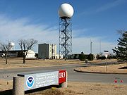
Installation of a prototype was completed in the Fall of 1990 in Norman, Oklahoma
Norman, Oklahoma
Norman is a city in Cleveland County, Oklahoma, United States, and is located south of downtown Oklahoma City. It is part of the Oklahoma City metropolitan area. As of the 2010 census, Norman was to have 110,925 full-time residents, making it the third-largest city in Oklahoma and the...
. The first installation of a WSR-88D for operational use in everyday forecasts was in Sterling, Virginia
Sterling, Virginia
Sterling, Virginia is a census-designated place in Loudoun County, Virginia. The population as of the 2010 Census was 27,822.It is located northwest of Herndon, east of Ashburn, and west of Great Falls, and includes part of Dulles International Airport and the former AOL corporate headquarters...
on June 12, 1992. The last system was installed in North Webster, Indiana
North Webster, Indiana
North Webster is a town in Tippecanoe Township, Kosciusko County, Indiana, United States. The population was 1,146 at the 2010 census.-Geography:North Webster is located at ....
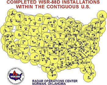
on August 30, 1997. The site locations were strategically chosen to provide the most overlapping coverage between radars in case one failed during a severe weather event. Where possible, they were co-located with NWS Weather Forecast Offices to permit quicker access to maintenance technicians.
The NEXRAD radars incorporated a number of improvements over the radar systems previously in use. The new system provided Doppler
Doppler
-Doppler effect and its applications:* Doppler effect* Doppler beaming* Doppler broadening* Doppler cooling** Doppler cooling limit* Doppler echocardiography** Doppler ultrasound, also called Doppler sonography** Transcranial doppler* Doppler fetal monitor...
velocity, improving tornado
Tornado
A tornado is a violent, dangerous, rotating column of air that is in contact with both the surface of the earth and a cumulonimbus cloud or, in rare cases, the base of a cumulus cloud. They are often referred to as a twister or a cyclone, although the word cyclone is used in meteorology in a wider...
prediction ability. It provided improved resolution and sensitivity, allowing operators to see features such as cold fronts, thunderstorm
Thunderstorm
A thunderstorm, also known as an electrical storm, a lightning storm, thundershower or simply a storm is a form of weather characterized by the presence of lightning and its acoustic effect on the Earth's atmosphere known as thunder. The meteorologically assigned cloud type associated with the...
gust fronts, and mesoscale
Mesoscale
Mesoscale may refer to:* Mesoscale meteorology* Mesoscopic scale in physics...
features of thunderstorms that had never been visible on radar. The NEXRAD radars also provided volumetric scans of the atmosphere allowing operators to interrogate the vertical structure of storms and provide detailed wind profiles above the radar site. The radars also had a much increased range allowing detection of weather features at much greater distances from the radar site.
Scan strategies
Unlike its predecessors, the WSR-88D antenna is not directly controllable by the user. Instead, the radar system continually refreshes its three-dimensional database via one of several predetermined scan patterns. Since the system samples the atmosphere in three dimensions, there are many variables that can be changed, depending on the desired output. There are currently nine Volume Coverage Patterns (VCP) available to NWS meteorologists. Each VCP is a predefined set of instructions given to the antenna that control the rotation speed, transmit/receive mode, and elevation angles. The radar operator chooses from the VCPs based on the type of weather occurring:- Clear Air or Light Precipitation: VCP 31 and 32
- Shallow Precipitation: VCP 21
- Convection: VCP 11, 12, 121, 211, 212, and 221
| VCP | Scan Time (min) | Elevation scans | Elevation angles (°) | Usage | Special attributes |
|---|---|---|---|---|---|
| 11 | 5 | 14 | 0.5, 1.5, 2.4, 3.4, 4.3, 5.3, 6.2, 7.5, 8.7, 10, 12, 14, 16.7, 19.5 | Convection, especially when close to the radar | Has the best overall volume coverage. |
| 211 | Convection, especially when close to the radar | Improves range-obscured velocity data over VCP 11 | |||
| 12 | 4.5 | 14 | 0.5, 0.9, 1.3, 1.8, 2.4, 3.1, 4.0, 5.1, 6.4, 8.0, 10.0, 12.5, 15.6, 19.5 | Convection, especially activity at longer ranges | Focuses on lower elevations to better sample the lower levels of storms. |
| 212 | Widespread severe convective events | Improves range-obscured velocity data over VCP 12 | |||
| 121 | 6 | 9 | 0.5, 1.5, 2.4, 3.4, 4.3, 6.0, 9.9, 14.6, 19.5 | Large number of rotating storms, tropical systems, or when better velocity data is needed. | Scans lower cuts multiple times with varying pulse repetitions to greatly enhance velocity data. |
| 21 | 5 | Shallow precipitation | Rarely used for convection due to sparse elevation data and long completion time. | ||
| 221 | Widespread precipitation with embedded convection. (i.e., tropical systems) | Improves range-obscured velocity data over VCP 121 | |||
| 31 | 10 | 5 | 0.5, 1.5, 2.5, 3.5, 4.5 | Detecting subtle boundaries or wintry precipitation | Long-pulse |
| 32 | Slow rotation speed allows for increased sensitivity. Default clear-air mode, reduces wear on antenna. | Short-pulse |
Super resolution
Deployed from March to August 2008, the Super Resolution upgrade is the capability of the radar to produce much higher resolution data. Under legacy resolution, the WSR-88D provides reflectivity data at 1 km by 1 degree to 460 km range, and velocity data at 0.25 km by 1 degree to a range of 230 km. Super Resolution provides reflectivity data with a sample size of 0.25 km by 0.5 degree, and increase the range of Doppler velocity data to 300 km. Initially the increased resolution is only available in the lower scan elevations. Super resolution makes a compromise of slightly decreased noise reduction for a large gain in resolution.The improvement in azimuthal resolution increases the range at which tornadic mesoscale rotations can be detected. This allows for faster lead time on warnings and extends the useful range of the radar. The increased resolution (in both azimuth and range) increases the detail of such rotations, giving a more accurate representation of the storm. Super Resolution also provides additional detail to aid in other severe storm analysis. Super Resolution extends the range of velocity data and provides it faster than before, also allowing for faster lead time on potential tornado detection and subsequent warnings.
Dual polarization
The next major upgrade is polarimetric radar, which adds vertical polarization to the current horizontalHorizontal plane
In geometry, physics, astronomy, geography, and related sciences, a plane is said to be horizontal at a given point if it is perpendicular to the gradient of the gravity field at that point— in other words, if apparent gravity makes a plumb bob hang perpendicular to the plane at that point.In...
radar
Radar
Radar is an object-detection system which uses radio waves to determine the range, altitude, direction, or speed of objects. It can be used to detect aircraft, ships, spacecraft, guided missiles, motor vehicles, weather formations, and terrain. The radar dish or antenna transmits pulses of radio...
wave
Wave
In physics, a wave is a disturbance that travels through space and time, accompanied by the transfer of energy.Waves travel and the wave motion transfers energy from one point to another, often with no permanent displacement of the particles of the medium—that is, with little or no associated mass...
s, in order to more accurately discern what is reflecting the signal. This so-called dual polarization allows the radar to distinguish between rain, hail and snow, something the horizontally polarized radars cannot accurately do. Early trials have shown that rain
Rain
Rain is liquid precipitation, as opposed to non-liquid kinds of precipitation such as snow, hail and sleet. Rain requires the presence of a thick layer of the atmosphere to have temperatures above the melting point of water near and above the Earth's surface...
, ice pellets
Ice pellets
Ice pellets are a form of precipitation consisting of small, translucent balls of ice. Ice pellets usually are smaller than hailstones. They often bounce when they hit the ground, and generally do not freeze into a solid mass unless mixed with freezing rain...
, snow
Snow
Snow is a form of precipitation within the Earth's atmosphere in the form of crystalline water ice, consisting of a multitude of snowflakes that fall from clouds. Since snow is composed of small ice particles, it is a granular material. It has an open and therefore soft structure, unless packed by...
, hail
Hail
Hail is a form of solid precipitation. It consists of balls or irregular lumps of ice, each of which is referred to as a hail stone. Hail stones on Earth consist mostly of water ice and measure between and in diameter, with the larger stones coming from severe thunderstorms...
, bird
Bird
Birds are feathered, winged, bipedal, endothermic , egg-laying, vertebrate animals. Around 10,000 living species and 188 families makes them the most speciose class of tetrapod vertebrates. They inhabit ecosystems across the globe, from the Arctic to the Antarctic. Extant birds range in size from...
s, insect
Insect
Insects are a class of living creatures within the arthropods that have a chitinous exoskeleton, a three-part body , three pairs of jointed legs, compound eyes, and two antennae...
s, and ground clutter all have different signatures with dual-polarization, which could mark a significant improvement in forecasting winter storm
Winter storm
A winter storm is an event in which the dominant varieties of precipitation are formed that only occur at low temperatures, such as snow or sleet, or a rainstorm where ground temperatures are low enough to allow ice to form...
s and severe thunderstorms. The deployment of the dual polarization capability (Build 12) to NEXRAD sites will begin in 2010 and last until 2012. The Vance AFB radar is the first operational WSR-88D to be modified to Dual Polarization. The modified radar went operational on 3 March 2011.
Phased array
Beyond dual-polarization, the advent of phased arrayPhased array
In wave theory, a phased array is an array of antennas in which the relative phases of the respective signals feeding the antennas are varied in such a way that the effective radiation pattern of the array is reinforced in a desired direction and suppressed in undesired directions.An antenna array...
radar will probably be the next major improvement in severe weather detection. Its ability to rapidly scan large areas would give an enormous advantage to radar meteorologists. Any large-scale installation by the NWS is unlikely to occur before 2020. Such a system would more likely be installed separate from the existing WSR-88D network, perhaps only in areas like the Great Plains
Great Plains
The Great Plains are a broad expanse of flat land, much of it covered in prairie, steppe and grassland, which lies west of the Mississippi River and east of the Rocky Mountains in the United States and Canada. This area covers parts of the U.S...
where tornadoes are more common.
Usage
NEXRAD data are used in multiple ways. It is used by National Weather Service meteorologists and is freely available to users outside of the NWS, including researchers, mediaMass media
Mass media refers collectively to all media technologies which are intended to reach a large audience via mass communication. Broadcast media transmit their information electronically and comprise of television, film and radio, movies, CDs, DVDs and some other gadgets like cameras or video consoles...
, and private citizens. The primary goal of NEXRAD data is to aid NWS meteorologists in operational forecasting
Forecasting
Forecasting is the process of making statements about events whose actual outcomes have not yet been observed. A commonplace example might be estimation for some variable of interest at some specified future date. Prediction is a similar, but more general term...
. The data allows them to accurately track precipitation
Precipitation (meteorology)
In meteorology, precipitation In meteorology, precipitation In meteorology, precipitation (also known as one of the classes of hydrometeors, which are atmospheric water phenomena is any product of the condensation of atmospheric water vapor that falls under gravity. The main forms of precipitation...
and anticipate its development and track. More importantly, it allows the meteorologists to track and anticipate severe weather
Severe weather
Severe weather phenomena are weather conditions that are hazardous to human life and property.- Examples Include :Severe weather can occur under a variety of situations, but three characteristics are generally needed: a temperature or moisture boundary, moisture, and , instability in the...
and tornadoes. Combined with ground reports, tornado
Tornado warning
A tornado warning is an alert issued by government weather services to warn that severe thunderstorms with tornadoes may be imminent. It can be issued after a tornado or funnel cloud has been spotted by eye, or more commonly if there are radar indications of tornado formation...
and severe thunderstorm
Severe thunderstorm warning
A severe thunderstorm warning is issued when trained storm spotters or a Doppler weather radar indicate a strong thunderstorm is producing dangerously large hail or high winds, capable of causing significant damage. In the United States, it does not account for lightning or flooding...
warnings can be issued to alert the public about dangerous storms. NEXRAD data also provides information about rainfall and aids in hydrology
Hydrology
Hydrology is the study of the movement, distribution, and quality of water on Earth and other planets, including the hydrologic cycle, water resources and environmental watershed sustainability...
forecasting. Data is provided to the public in several different forms. The most basic form is graphics published to the NWS website. Data is also available in two similar, but different, raw formats. Available directly from the NWS is Level III data. Level III data consists of reduced resolution, low-bandwidth, base products as well as many derived, post-processed products. Level II data consists of only the base products, but at their original resolution. Because of the higher bandwidth costs, Level II data is not available directly from the NWS. The NWS distributes this data freely to several top-tier universities who in turn distribute the data to private organizations.
Operational Locations
| State | City or Place Name | ICAO Location Identifier International Civil Aviation Organization airport code The ICAO airport code or location indicator is a four-character alphanumeric code designating each airport around the world. These codes are defined by the International Civil Aviation Organization, and published in ICAO Document 7910: Location Indicators.The ICAO codes are used by air traffic... |
Coordinates |
|---|---|---|---|
| PR | San Juan | TJUA | 18.1155998°N 66.0780644°W |
| ME | Loring AFB | KCBW | 46.0391944°N 67.8066033°W |
| ME | Portland | KGYX | 43.8913555°N 70.2565545°W |
| VT | Burlington | KCXX | 44.5109941°N 73.166424°W |
| MA | Boston | KBOX | 41.9558919°N 71.1369681°W |
| NY | Albany | KENX | 42.5865699°N 74.0639877°W |
| NY | Binghamton | KBGM | 42.1997045°N 75.9847015°W |
| NY | Buffalo | KBUF | 42.9488055°N 78.7369108°W |
| NY | Montague | KTYX | 43.7556319°N 75.6799918°W |
| NY | New York City | KOKX | 40.8655093°N 72.8638548°W |
| DE | Dover AFB | KDOX | 38.8257651°N 75.4400763°W |
| PA | Philadelphia | KDIX | 39.9470885°N 74.4108027°W |
| PA | Pittsburgh | KPBZ | 40.5316842°N 80.2179515°W |
| PA | State College | KCCX | 40.9228521°N 78.0038738°W |
| WV | Charleston | KRLX | 38.3110763°N 81.7229015°W |
| VA | Norfolk/Richmond | KAKQ | 36.9840475°N 77.007342°W |
| VA | Roanoke | KFCX | 37.0242098°N 80.2736664°W |
| VA | Sterling | KLWX | 38.9753957°N 77.4778444°W |
| NC | Morehead City | KMHX | 34.7759313°N 76.8762571°W |
| NC | Raleigh/Durham | KRAX | 35.6654967°N 78.4897855°W |
| NC | Wilmington | KLTX | 33.9891631°N 78.4291059°W |
| SC | Charleston | KCLX | 32.6554866°N 81.0423124°W |
| SC | Columbia | KCAE | 33.9487579°N 81.1184281°W |
| SC | Greer | KGSP | 34.8833435°N 82.2200757°W |
| GA | Atlanta | KFFC | 33.3635771°N 84.565866°W |
| GA | Moody AFB | KVAX | 30.8903853°N 83.0019021°W |
| GA | Robins AFB | KJGX | 32.6755239°N 83.3508575°W |
| FL | Eglin AFB | KEVX | 30.5649908°N 85.921559°W |
| FL | Jacksonville | KJAX | 30.4846878°N 81.7018917°W |
| FL | Key West | KBYX | 24.5974996°N 81.7032355°W |
| FL | Melbourne | KMLB | 28.1131808°N 80.6540988°W |
| FL | Miami | KAMX | 25.6111275°N 80.412747°W |
| FL | Tallahassee | KTLH | 30.397568°N 84.3289116°W |
| FL | Tampa | KTBW | 27.7054701°N 82.40179°W |
| AL | Birmingham | KBMX | 33.1722806°N 86.7698425°W |
| AL | Fort Rucker | KEOX | 31.4605622°N 85.4592401°W |
| AL | Huntsville | KHTX | 34.930508°N 86.0837388°W |
| AL | Maxwell AFB | KMXX | 32.5366608°N 85.7897848°W |
| AL | Mobile | KMOB | 30.6795378°N 88.2397816°W |
| MS | Brandon/Jackson | KDGX | 32.2797358°N 89.9846309°W |
| MS | Columbus AFB | KGWX | 33.8967796°N 88.3293915°W |
| TN | Knoxville/Tri Cities | KMRX | 36.168538°N 83.401779°W |
| TN | Memphis | KNQA | 35.3447802°N 89.8734534°W |
| TN | Nashville | KOHX | 36.2472389°N 86.5625185°W |
| KY | Fort Campbell | KHPX | 36.7368894°N 87.2854328°W |
| KY | Jackson | KJKL | 37.590762°N 83.313039°W |
| KY | Louisville | KLVX | 37.9753058°N 85.9438455°W |
| KY | Paducah | KPAH | 37.0683618°N 88.7720257°W |
| OH | Wilmington | KILN | 39.5083314°N 83.8176925°W |
| OH | Cleveland | KCLE | 41.4131875°N 81.8597451°W |
| MI | Detroit/Pontiac | KDTX | 42.6999677°N 83.471809°W |
| MI | Gaylord | KAPX | 44.907106°N 84.719817°W |
| MI | Grand Rapids | KGRR | 42.893872°N 85.5449206°W |
| MI | Marquette | KMQT | 46.5311443°N 87.5487131°W |
| IN | Evansville | KVWX | 38.2603901°N 87.7246553°W |
| IN | Indianapolis | KIND | 39.7074962°N 86.2803675°W |
| IN | North Webster | KIWX | 41.3586356°N 85.7000488°W |
| IL | Chicago | KLOT | 41.6044264°N 88.084361°W |
| IL | Lincoln | KILX | 40.150544°N 89.336842°W |
| WI | Green Bay | KGRB | 44.4984644°N 88.111124°W |
| WI | La Crosse | KARX | 43.822766°N 91.1915767°W |
| WI | Milwaukee | KMKX | 42.9678286°N 88.5506335°W |
| MN | Duluth | KDLH | 46.8368569°N 92.2097433°W |
| MN | Minneapolis/St. Paul | KMPX | 44.8488029°N 93.5654873°W |
| IA | Davenport | KDVN | 41.611556°N 90.5809987°W |
| IA | Des Moines | KDMX | 41.7311788°N 93.7229235°W |
| MO | Kansas City | KEAX | 38.8102231°N 94.2644924°W |
| MO | Springfield | KSGF | 37.235223°N 93.4006011°W |
| MO | St. Louis | KLSX | 38.6986863°N 90.682877°W |
| AR | Fort Smith | KSRX | 35.2904423°N 94.3619075°W |
| AR | Little Rock | KLZK | 34.8365261°N 92.2621697°W |
| LA | Fort Polk | KPOE | 31.1556923°N 92.9762596°W |
| LA | Lake Charles | KLCH | 30.125382°N 93.2161188°W |
| LA | New Orleans | KLIX | 30.3367133°N 89.8256618°W |
| LA | Shreveport | KSHV | 32.450813°N 93.8412774°W |
| TX | Amarillo | KAMA | 35.2334827°N 101.7092478°W |
| TX | Austin/San Antonio | KEWX | 29.7039802°N 98.028506°W |
| TX | Brownsville | KBRO | 25.9159979°N 97.4189526°W |
| TX | Corpus Christi | KCRP | 27.7840203°N 97.511234°W |
| TX | Dallas/Ft. Worth | KFWS | 32.5730186°N 97.3031911°W |
| TX | Dyess AFB | KDYX | 32.5386009°N 99.2542863°W |
| TX | El Paso | KEPZ | 31.8731115°N 106.697942°W |
| TX | Fort Hood | KGRK | 30.7217637°N 97.3829627°W |
| TX | Houston/Galveston | KHGX | 29.4718835°N 95.0788593°W |
| TX | Laughlin AFB | KDFX | 29.2730823°N 100.2802312°W |
| TX | Lubbock | KLBB | 33.6541242°N 101.814149°W |
| TX | Midland/Odessa | KMAF | 31.9433953°N 102.1894383°W |
| TX | San Angelo | KSJT | 31.3712815°N 100.4925227°W |
| OK | Frederick | KFDR | 34.3620014°N 98.9766884°W |
| OK | Oklahoma City | KTLX | 35.3333873°N 97.2778255°W |
| OK | Tulsa | KINX | 36.1750977°N 95.5642802°W |
| OK | Vance AFB | KVNX | 36.7406166°N 98.1279409°W |
| KS | Dodge City | KDDC | 37.7608043°N 99.9688053°W |
| KS | Goodland | KGLD | 39.3667737°N 101.7004341°W |
| KS | Topeka | KTWX | 38.996998°N 96.232618°W |
| KS | Wichita | KICT | 37.6545724°N 97.4431461°W |
| NE | Grand Island/Hastings | KUEX | 40.320966°N 98.4418559°W |
| NE | North Platte | KLNX | 41.9579623°N 100.5759609°W |
| NE | Omaha | KOAX | 41.3202803°N 96.3667971°W |
| SD | Aberdeen | KABR | 45.4558185°N 98.4132046°W |
| SD | Rapid City | KUDX | 44.1248485°N 102.8298157°W |
| SD | Sioux Falls | KFSD | 43.5877467°N 96.7293674°W |
| ND | Bismarck | KBIS | 46.7709329°N 100.7605532°W |
| ND | Grand Forks (Mayville) | KMVX | 47.5279417°N 97.3256654°W |
| ND | Minot AFB | KMBX | 48.39303°N 100.8644378°W |
| MT | Billings | KBLX | 45.8537632°N 108.6068165°W |
| MT | Glasgow | KGGW | 48.2064536°N 106.6252971°W |
| MT | Great Falls | KTFX | 47.4595023°N 111.3855368°W |
| MT | Missoula | KMSX | 47.0412971°N 113.9864373°W |
| WY | Cheyenne | KCYS | 41.1519308°N 104.8060325°W |
| WY | Riverton | KRIW | 43.0660779°N 108.4773731°W |
| CO | Denver | KFTG | 39.7866156°N 104.5458126°W |
| CO | Grand Junction | KGJX | 39.0619824°N 108.2137012°W |
| CO | Pueblo | KPUX | 38.4595034°N 104.1816223°W |
| NM | Albuquerque | KABX | 35.1497579°N 106.8239576°W |
| NM | Cannon AFB | KFDX | 34.6341569°N 103.6186427°W |
| NM | Holloman AFB | KHDX | 33.0768844°N 106.1200923°W |
| AZ | Flagstaff | KFSX | 34.574449°N 111.198367°W |
| AZ | Phoenix | KIWA | 33.289111°N 111.6700092°W |
| AZ | Tucson | KEMX | 31.8937186°N 110.6304306°W |
| AZ | Yuma | KYUX | 32.4953477°N 114.6567214°W |
| UT | Cedar City | KICX | 37.5931771°N 112.8637719°W |
| UT | Salt Lake City | KMTX | 41.2627795°N 112.4480081°W |
| ID | Boise | KCBX | 43.4902104°N 116.2360436°W |
| ID | Pocatello/Idaho Falls | KSFX | 43.1055967°N 112.6860487°W |
| NV | Elko | KLRX | 40.7396933°N 116.8025529°W |
| NV | Las Vegas | KESX | 35.7012894°N 114.8918277°W |
| NV | Reno | KRGX | 39.7541931°N 119.4620597°W |
| CA | Beale AFB | KBBX | 39.4956958°N 121.6316557°W |
| CA | Edwards AFB | KEYX | 35.0979358°N 117.5608832°W |
| CA | Eureka | KBHX | 40.4986955°N 124.2918867°W |
| CA | Los Angeles | KVTX | 34.4116386°N 119.1795641°W |
| CA | Sacramento | KDAX | 38.5011529°N 121.6778487°W |
| CA | San Diego | KNKX | 32.9189891°N 117.041814°W |
| CA | San Francisco | KMUX | 37.155152°N 121.8984577°W |
| CA | San Joaquin Valley | KHNX | 36.3142088°N 119.6320903°W |
| CA | Santa Ana Mountains | KSOX | 33.8176452°N 117.6359743°W |
| CA | Vandenberg AFB | KVBX | 34.8383137°N 120.3977805°W |
| HI | Kauai | PHKI | 21.8938762°N 159.5524585°W |
| HI | Kohala | PHKM | 20.1254606°N 155.778054°W |
| HI | Molokai | PHMO | 21.1327531°N 157.1802807°W |
| HI | South Shore | PHWA | 19.0950155°N 155.5688846°W |
| OR | Medford | KMAX | 42.0810766°N 122.7173334°W |
| OR | Pendleton | KPDT | 45.6906118°N 118.8529301°W |
| OR | Portland | KRTX | 45.7150308°N 122.9650542°W |
| WA | Langley Hill | KLGX | 47.111°N 124.102°W |
| WA | Seattle/Tacoma | KATX | 48.1945614°N 122.4957508°W |
| WA | Spokane | KOTX | 47.6803744°N 117.6267797°W |
| AK | Bethel | PABC | 60.791987°N 161.876539°W |
| AK | Fairbanks/Pedro Dome | PAPD | 65.0351238°N 147.5014222°W |
| AK | Kenai | PAHG | 60.6156335°N 151.2832296°W |
| AK | King Salmon | PAKC | 58.6794558°N 156.6293335°W |
| AK | Middleton Island | PAIH | 59.46194°N 146.30111°W |
| AK | Nome | PAEC | 64.5114973°N 165.2949071°W |
| AK | Sitka/Biorka Island | PACG | 56.85214°N 135.552417°W |
| GU | Andersen AFB | PGUA | 13.455965°N 144.8111022°W |
| NA | Lajes Field Lajes Field Lajes Field or Lajes Air Base , officially designated Air Base No. 4 , is a multi-use air field, home to the Portuguese Air Force Base Aérea Nº4 and Azores Air Zone Command , a United States Air Force detachment , and a regional air passenger terminal located near Lajes... , Azores |
LPLA | 38.73028°N 27.32167°W |
| NA | Kunsan Air Base Kunsan Air Base Kunsan Air Base , is a United States Air Force base located on the west coast of the South Korean peninsula bordered by the Yellow Sea. It is at the town of Gunsan about 150 miles south of Seoul. The town can be romanized as both Gunsan and Kunsan... , South Korea |
RKJK | 35.92417°N 126.62222°W |
| NA | Camp Humphreys Camp Humphreys Camp Humphreys or USAG-H is a medium-sized United States Army garrison located near Anjeong-ri and south of Pyeongtaek metropolitan area in South Korea. Camp Humphreys is located 55 miles south of Seoul and is one of the U.S. Army's fastest growing installations... , South Korea |
RKSG | 36.95972°N 127.01833°W |
| NA | Kadena Air Base Kadena Air Base , is a United States Air Force base in the towns of Kadena and Chatan and the city of Okinawa, in Okinawa Prefecture, Japan. Kadena Air Base is the hub of U.S. airpower in the Pacific, and home to the USAF's 18th Wing and a variety of associate units.-Units:The 18th Wing is the host unit at Kadena... , Japan |
RODN | 26.30194°N 127.90972°W |
See also
- LLWSAS
- Canadian weather radar networkCanadian weather radar networkThe Canadian weather radar network consists of 31 weather radars spanning Canada's most populated regions. Their primary purpose is the early detection of precipitation, its motion and the threat it poses to life and property...
External links
Theory of Doppler Weather Radar- Frequently Asked Questions by NOAA
- Radar Frequently Asked Questions (FAQ) by Weather Underground
- Social & Economic Benefits of NEXRAD from "NOAA Socioeconomics" website initiative
Real time data
Research
- RADAR Research and Development by NSSLNational Severe Storms LaboratoryThe National Severe Storms Laboratory is a National Oceanic and Atmospheric Administration weather research laboratory located at the National Weather Center in Norman, Oklahoma....