

Touchet Formation
Encyclopedia
The Touchet Formation or Touchet beds consist of large quantities of gravel
and fine sediment
which overlay almost a thousand meters (several thousand feet) of volcanic basalt
of the Columbia River Basalt Group
in south-central Washington and north-central Oregon
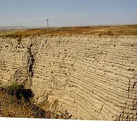
. The beds consist of between 6 to 40 distinct rhythmite
s - horizontal layers of sediment, each clearly demarcated from the layer below. These Touchet beds are often covered by windblown loess
soils which were deposited later; the number of layers varies with location. The beds vary in depth from 330 feet (100.6 m) at lower elevations where a number of layers can be found to a few extremely thin layers at the maximum elevation where they are observed (1150 feet (350.5 m)).
The Touchet beds are one element in a chain of evidence which helped identify and define the progression of the Missoula Floods
, which occurred around 16,450 to 13,750 years BCE
. During the floods, flow through the Wallula Gap
was slow enough such that water pooled in a temporary lake, Lake Lewis
. Lake Lewis back-flooded up the Yakima
, Walla Walla
, Touchet
and Tucannon River
Valleys. In these relatively calm arms of the lake, the slack waters deposited the suspended materials eroded from the scabland regions
north of Lake Lewis, and redeposited them in pronounced layers before receding.
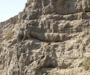
Although visible along the Walla Walla and Touchet rivers, the Touchet Beds were not subjected to study until the early 20th century. They remain at the center of scientific analyses to characterize the Missoula Floods.
for the Touchet Formation is the confluence of the Touchet River with the Walla Walla River, and was originally observed by Richard Foster Flint in 1938. Numerous other examples were subsequently identified throughout the basin of the former Lake Lewis and Lake Condon
.
published a paper arguing that the channeled scablands
in Eastern Washington
were caused by massive flooding in the distant past. This view, which was seen as arguing for a Catastrophic
explanation for the geologic development, which ran counter the then prevailing view of uniformitarianism
, and Bretz's views were initially decried. Bretz defended his theories, setting off a forty year debate over the Missoula Floods
before Bretz’s view of a catastrophic flood finally prevailed. Waitt extended Bretz's argument, arguing for a sequence of multiple Missoula Floods — 40 or more. Waitt's proposal was based mainly on analysis from glacial lake bottom deposits in Ninemile Creek and the Touchet Formation deposits in Burlingame Canyon. This represented a move away from a single catastrophic flood toward a series of catastrophic floods, but with the flood source still ascribed to Glacial Lake Missoula.
The controversy whether the Channeled Scabland landforms were formed mainly by multiple periodic large floods or by a single grand-scale cataclysmic flood from either late Pleistocene Glacial Lake Missoula or an unidentified Canadian source reappeared in 1999. Shaw’s team reviewed the sedimentary sequences of the Touchet beds and concluded that the sequences do not automatically imply multiple floods separated by decades or centuries. Rather, they proposed that sedimentation in the Glacial Lake Missoula basin was the result of jökulhlaups draining into Lake Missoula from British Columbia to the north. Shaw's team proposed that the rhythmic Touchet beds are the result of multiple pulses, or surges, within a single larger flood. In response, Atwater’s team observed that there is substantial evidence for multiple large floods, including evidence of mud cracks and animal burrows in lower layers of the Touchet beds, which were filled by sediment from later floods.
Recent scientific investigations support Waitt’s proposed separation of layers into records of sequential flood events. Although the various sources support temporal separation of floods, they do not definitively identify the source of water for all of the floods, though they all agree that Lake Missoula was source for at least some of them.
, around 16,450 to 13,750 BCE, and during the Bonneville Flood
that occurred in approximately 12,500 BCE. Another potential source for periodic flooding, still somewhat controversial, is flood release by jökulhlaup
s from subglacial lakes in British Columbia
, but no specific source for these jökulhlaups has yet been identified.
During the floods, flow through the narrow Wallula Gap was restricted such that water pooled in a temporary lake, Lake Lewis
, which formed in the lowlands of the Columbia Plateau
. Lake Lewis backflooded up the Yakima, Walla Walla, Touchet and Tucannon River valleys. This flooding lasted for a period of 4–7 days. In the relatively calm arms of the lake, the slack waters were thick with suspended materials eroded from the scablands
above. Some of the suspended materials settled out, creating thick Touchet Formation layers, or rhythmites, which are found throughout these valleys. The larger clasts settled out first, followed by the finer ones. This resulted in layers with graded bedding
, or bedding in which the larger particles are at the bottom and the smaller ones are at the top.
In 1980, R. B. Waitt studied the Touchet Formation in the wall of the Burlingame Canyon west of Walla Walla, Washington, where he counted at least 41 distinct flood deposit layers. He postulated that these floods could occur only when glacial Lake Missoula existed, which estimates place at 16,450 to 13,750 BCE. More recent studies have used radiocarbon dating
to establish the approximate ages of deposition for the various layers.
The side valleys were protected from the violent currents of the main channel; as a result the flood strata laid down by earlier floods were not eroded away by subsequent floods, but were buried and preserved. The average period between flood episodes is estimated to be 20 to 60 years. The periodicity estimates are based on a number of constraints:
The Touchet Formation was originally identified at the confluence of the Touchet River with the Walla Walla River. It is also found at some distance up the Touchet River Valley. The number of layers observed decreases as one progresses up-valley, indicating that the floodwater lakes varied in depth and distance upstream from the various flood dams. Clastic dike
intrusions are observed in some locations penetrating the layers vertically; the dikes are infill
ed with uniform-size fine-grained materials and are indications that the period between floods was long enough that the deposits dried, forming vertical cracks and allowing wind-blown eroded materials to infill the cracks.
The Walla Walla River Valley is a closed basin
. The river passes through a narrow gap near its confluence with the Columbia River and then widens into a broad open valley floor about 8 miles (12.9 km) above the confluence with the Columbia. This area was filled to varying depths by the successive Missoula Floods, and sediments settled out to form the Touchet beds over much of the basin, creating what is today a fertile farmland region. In the lowest part of the broader valley, to the east of the Columbia River and west of the city of Walla Walla, Washington
, soils commonly form on Touchet beds. In several locations erosion has exposed these beds. One outcrop
, the Gardena Terrace segment of the rhythmites, can be seen along the highway west of Walla Walla. The Touchet Formation is also extensively exposed at Burlingame Canyon, just southwest of the town of Touchet near the confluence of the Touchet and Walla Walla Rivers. The deposits are also found along tributaries to the Walla Walla, extending some distance south into Oregon
.
Lake Lewis extended up the Yakima Valley, flooding an area of about 600 square miles (1,554 km²) of the valley and covering the area now occupied by the city of Yakima
by about 200 feet (61 m). The valley extends for 80 miles (128.7 km), widening westwards above the Chandler Narrows and then narrowing again at Union Gap just below Yakima. The Toppenish Basin and Benton Basin of the lower Yakima River both contain large amounts of Touchet Formation deposits. Rhythmites are extensively exposed 1 mile (2 km) north of Mabton
and at Zillah
. Ice rafted
erratics are also commonly found in these beds.
deposits from the Missoula and Bonneville floods. Although they lie some distance up the Snake River
drainage, the flood waters of Lake Lewis backed up this drainage far enough to deposit sediments. Floodplain deposits consist of up to six distinct Touchet Beds, as well as loess silt and fine sand. These alluvial and loess deposits narrow as they approach the basalt
valley walls, and thicken into the central valley, with a maximum sediment thickness of between 20 and 100 ft (6.1 and 30.5 m). Due to the elevation of the valley, only six of the flooding events caused water to back into the Tucannon Valley in sufficient volume to deposit distinct layers.
that formed in the floodwaters behind the Saddle Mountains
.
. This lake back-flooded into the Umatilla and John Day River Valleys as well as other tributaries. As one example, silt-sand rhythmites associated with the Missoula Floods are present along Willow Creek, a valley tributary to the Columbia River. Willow Creek conflues with the Columbia a few miles west of Boardman, Oregon
. Excellent exposures of the unit (which contains abundant clastic dikes) can be found in roadcuts along Hwy 74 (Heppner Highway) near the ranching community of Cecil, Oregon
. These deposits result from slackwater deposits associated with Lake Condon
ponding of Missoula floodwaters downstream of Wallula Gap.
Gravel
Gravel is composed of unconsolidated rock fragments that have a general particle size range and include size classes from granule- to boulder-sized fragments. Gravel can be sub-categorized into granule and cobble...
and fine sediment
Sediment
Sediment is naturally occurring material that is broken down by processes of weathering and erosion, and is subsequently transported by the action of fluids such as wind, water, or ice, and/or by the force of gravity acting on the particle itself....
which overlay almost a thousand meters (several thousand feet) of volcanic basalt
Basalt
Basalt is a common extrusive volcanic rock. It is usually grey to black and fine-grained due to rapid cooling of lava at the surface of a planet. It may be porphyritic containing larger crystals in a fine matrix, or vesicular, or frothy scoria. Unweathered basalt is black or grey...
of the Columbia River Basalt Group
Columbia River Basalt Group
The Columbia River Basalt Group is a large igneous province that lies across parts of the Western United States. It is found in the U.S. states of Washington, Oregon, Idaho, Nevada, and California...
in south-central Washington and north-central Oregon
Oregon
Oregon is a state in the Pacific Northwest region of the United States. It is located on the Pacific coast, with Washington to the north, California to the south, Nevada on the southeast and Idaho to the east. The Columbia and Snake rivers delineate much of Oregon's northern and eastern...
. The beds consist of between 6 to 40 distinct rhythmite
Rhythmite
A rhythmite consists of layers of sediment or sedimentary rock which are laid down with an obvious periodicity and regularity. They may be created by annual processes such as seasonally varying deposits reflecting variations in the runoff cycle, by shorter term processes such as tides, or by longer...
s - horizontal layers of sediment, each clearly demarcated from the layer below. These Touchet beds are often covered by windblown loess
Loess
Loess is an aeolian sediment formed by the accumulation of wind-blown silt, typically in the 20–50 micrometre size range, twenty percent or less clay and the balance equal parts sand and silt that are loosely cemented by calcium carbonate...
soils which were deposited later; the number of layers varies with location. The beds vary in depth from 330 feet (100.6 m) at lower elevations where a number of layers can be found to a few extremely thin layers at the maximum elevation where they are observed (1150 feet (350.5 m)).
The Touchet beds are one element in a chain of evidence which helped identify and define the progression of the Missoula Floods
Missoula Floods
The Missoula Floods refer to the cataclysmic floods that swept periodically across eastern Washington and down the Columbia River Gorge at the end of the last ice age. The glacial flood events have been researched since the 1920s...
, which occurred around 16,450 to 13,750 years BCE
Common Era
Common Era ,abbreviated as CE, is an alternative designation for the calendar era originally introduced by Dionysius Exiguus in the 6th century, traditionally identified with Anno Domini .Dates before the year 1 CE are indicated by the usage of BCE, short for Before the Common Era Common Era...
. During the floods, flow through the Wallula Gap
Wallula Gap
Wallula Gap is a large water gap of the Columbia River through basalt anticlines in the Columbia River Basin in the U.S. state of Washington, just south of the confluence of the Walla Walla and Columbia rivers...
was slow enough such that water pooled in a temporary lake, Lake Lewis
Lake Lewis
Lake Lewis was a temporary lake in the Pacific Northwest region of North America, largely formed by the Missoula Floods in about the 14th millennium B.C....
. Lake Lewis back-flooded up the Yakima
Yakima River
The Yakima River is a tributary of the Columbia River in south central and eastern Washington State, named for the indigenous Yakama people. The length of the river from headwaters to mouth is , with an average drop of .-Course:...
, Walla Walla
Walla Walla River
The Walla Walla River is a tributary of the Columbia River, joining the Columbia just above Wallula Gap in southeastern Washington in the United States. The river flows through Umatilla County, Oregon and Walla Walla County, Washington. Its drainage basin is in area.-Course:The headwaters of the...
, Touchet
Touchet River
The Touchet River is the largest tributary of the Walla Walla River in southeastern Washington in the United States.The upper Touchet was a traditional summer meeting place for trade and games for the Palus, Nez Perce and Walla Walla tribes. The name Touchet derives from the similarly pronounced...
and Tucannon River
Tucannon River
The Tucannon River is a river in southeastern Washington state that flows from headwaters in the Blue Mountains to a confluence with the Snake River upstream from Lyons Ferry Park and the mouth of the Palouse River. The Tucannon itself drains and is long...
Valleys. In these relatively calm arms of the lake, the slack waters deposited the suspended materials eroded from the scabland regions
Channeled scablands
The Channeled Scablands are a unique geological erosion feature in the U.S. state of Washington. They were created by the cataclysmic Missoula Floods that swept periodically across eastern Washington and down the Columbia River Plateau during the Pleistocene epoch. Geologist J Harlen Bretz coined...
north of Lake Lewis, and redeposited them in pronounced layers before receding.
Discovery and interpretation
Although visible along the Walla Walla and Touchet rivers, the Touchet Beds were not subjected to study until the early 20th century. They remain at the center of scientific analyses to characterize the Missoula Floods.
Type locality
The type localityType locality (geology)
Type locality , also called type area or type locale, is the where a particular rock type, stratigraphic unit, fossil or mineral species is first identified....
for the Touchet Formation is the confluence of the Touchet River with the Walla Walla River, and was originally observed by Richard Foster Flint in 1938. Numerous other examples were subsequently identified throughout the basin of the former Lake Lewis and Lake Condon
Lake Condon
Lake Condon was a temporary lake in the Pacific Northwest region of North America, formed periodically by the Missoula Floods from 15,000 to 13,000 BC....
.
Early interpretation
In 1923 J Harlen BretzJ Harlen Bretz
J Harlen Bretz was an American geologist, best known for his research that led to the acceptance of the Missoula Floods, and also for his work on caves. He was born to Oliver Joseph Bretz and Rhoda Maria Howlett, farmers in Saranac, Michigan, as the oldest of five children...
published a paper arguing that the channeled scablands
Channeled scablands
The Channeled Scablands are a unique geological erosion feature in the U.S. state of Washington. They were created by the cataclysmic Missoula Floods that swept periodically across eastern Washington and down the Columbia River Plateau during the Pleistocene epoch. Geologist J Harlen Bretz coined...
in Eastern Washington
Eastern Washington
Eastern Washington is the portion of the U.S. state of Washington east of the Cascade Range. The region contains the city of Spokane , the Tri-Cities, the Columbia River and the Grand Coulee Dam, the Hanford Nuclear Reservation and the fertile farmlands of the Yakima Valley and the...
were caused by massive flooding in the distant past. This view, which was seen as arguing for a Catastrophic
Catastrophism
Catastrophism is the theory that the Earth has been affected in the past by sudden, short-lived, violent events, possibly worldwide in scope. The dominant paradigm of modern geology is uniformitarianism , in which slow incremental changes, such as erosion, create the Earth's appearance...
explanation for the geologic development, which ran counter the then prevailing view of uniformitarianism
Uniformitarianism (science)
In the philosophy of naturalism, the uniformitarianism assumption is that the same natural laws and processes that operate in the universe now, have always operated in the universe in the past and apply everywhere in the universe. It has included the gradualistic concept that "the present is the...
, and Bretz's views were initially decried. Bretz defended his theories, setting off a forty year debate over the Missoula Floods
Missoula Floods
The Missoula Floods refer to the cataclysmic floods that swept periodically across eastern Washington and down the Columbia River Gorge at the end of the last ice age. The glacial flood events have been researched since the 1920s...
before Bretz’s view of a catastrophic flood finally prevailed. Waitt extended Bretz's argument, arguing for a sequence of multiple Missoula Floods — 40 or more. Waitt's proposal was based mainly on analysis from glacial lake bottom deposits in Ninemile Creek and the Touchet Formation deposits in Burlingame Canyon. This represented a move away from a single catastrophic flood toward a series of catastrophic floods, but with the flood source still ascribed to Glacial Lake Missoula.
The controversy whether the Channeled Scabland landforms were formed mainly by multiple periodic large floods or by a single grand-scale cataclysmic flood from either late Pleistocene Glacial Lake Missoula or an unidentified Canadian source reappeared in 1999. Shaw’s team reviewed the sedimentary sequences of the Touchet beds and concluded that the sequences do not automatically imply multiple floods separated by decades or centuries. Rather, they proposed that sedimentation in the Glacial Lake Missoula basin was the result of jökulhlaups draining into Lake Missoula from British Columbia to the north. Shaw's team proposed that the rhythmic Touchet beds are the result of multiple pulses, or surges, within a single larger flood. In response, Atwater’s team observed that there is substantial evidence for multiple large floods, including evidence of mud cracks and animal burrows in lower layers of the Touchet beds, which were filled by sediment from later floods.
Source of the Touchet Formation: current understanding
Recent scientific investigations support Waitt’s proposed separation of layers into records of sequential flood events. Although the various sources support temporal separation of floods, they do not definitively identify the source of water for all of the floods, though they all agree that Lake Missoula was source for at least some of them.
Formation
The Touchet beds are formed of sediment which deposited during the various Missoula FloodsMissoula Floods
The Missoula Floods refer to the cataclysmic floods that swept periodically across eastern Washington and down the Columbia River Gorge at the end of the last ice age. The glacial flood events have been researched since the 1920s...
, around 16,450 to 13,750 BCE, and during the Bonneville Flood
Bonneville Flood
The Bonneville Flood or Lake Bonneville Flood was a catastrophic flooding event in the previous ice age, which involved massive amounts of water inundating parts of southern Idaho and eastern Washington along the course of the Snake River. Unlike the Missoula Floods, which also occurred during the...
that occurred in approximately 12,500 BCE. Another potential source for periodic flooding, still somewhat controversial, is flood release by jökulhlaup
Jökulhlaup
A jökulhlaup is a glacial outburst flood. It is an Icelandic term that has been adopted by the English language. It originally referred to the well-known subglacial outburst floods from Vatnajökull, Iceland which are triggered by geothermal heating and occasionally by a volcanic subglacial...
s from subglacial lakes in British Columbia
British Columbia
British Columbia is the westernmost of Canada's provinces and is known for its natural beauty, as reflected in its Latin motto, Splendor sine occasu . Its name was chosen by Queen Victoria in 1858...
, but no specific source for these jökulhlaups has yet been identified.
During the floods, flow through the narrow Wallula Gap was restricted such that water pooled in a temporary lake, Lake Lewis
Lake Lewis
Lake Lewis was a temporary lake in the Pacific Northwest region of North America, largely formed by the Missoula Floods in about the 14th millennium B.C....
, which formed in the lowlands of the Columbia Plateau
Columbia Plateau
The Columbia Plateau is a geologic and geographic region that lies across parts of the U.S. states of Washington, Oregon, and Idaho. It is a wide flood basalt plateau between the Cascade Range and the Rocky Mountains, cut through by the Columbia River...
. Lake Lewis backflooded up the Yakima, Walla Walla, Touchet and Tucannon River valleys. This flooding lasted for a period of 4–7 days. In the relatively calm arms of the lake, the slack waters were thick with suspended materials eroded from the scablands
Channeled scablands
The Channeled Scablands are a unique geological erosion feature in the U.S. state of Washington. They were created by the cataclysmic Missoula Floods that swept periodically across eastern Washington and down the Columbia River Plateau during the Pleistocene epoch. Geologist J Harlen Bretz coined...
above. Some of the suspended materials settled out, creating thick Touchet Formation layers, or rhythmites, which are found throughout these valleys. The larger clasts settled out first, followed by the finer ones. This resulted in layers with graded bedding
Graded bedding
In geology, a graded bed is one characterized by a systematic change in grain or clast size from the base of the bed to the top. Most commonly this takes the form of normal grading, with coarser sediments at the base, which grade upward into progressively finer ones...
, or bedding in which the larger particles are at the bottom and the smaller ones are at the top.
Periodicity
In 1980, R. B. Waitt studied the Touchet Formation in the wall of the Burlingame Canyon west of Walla Walla, Washington, where he counted at least 41 distinct flood deposit layers. He postulated that these floods could occur only when glacial Lake Missoula existed, which estimates place at 16,450 to 13,750 BCE. More recent studies have used radiocarbon dating
Radiocarbon dating
Radiocarbon dating is a radiometric dating method that uses the naturally occurring radioisotope carbon-14 to estimate the age of carbon-bearing materials up to about 58,000 to 62,000 years. Raw, i.e. uncalibrated, radiocarbon ages are usually reported in radiocarbon years "Before Present" ,...
to establish the approximate ages of deposition for the various layers.
The side valleys were protected from the violent currents of the main channel; as a result the flood strata laid down by earlier floods were not eroded away by subsequent floods, but were buried and preserved. The average period between flood episodes is estimated to be 20 to 60 years. The periodicity estimates are based on a number of constraints:
- The time to recharge Lake Missoula depends upon the level at which the dam is breached releasing the flood as well as upon the adjusted precipitation rate in the drainages flowing into Lake Missoula. For the volumes which correspond to calculated maximum flow rates, this is estimated to take from 20 to 80 years.
- PaleomagneticPaleomagnetismPaleomagnetism is the study of the record of the Earth's magnetic field in rocks. Certain minerals in rocks lock-in a record of the direction and intensity of the magnetic field when they form. This record provides information on the past behavior of Earth's magnetic field and the past location of...
orientations from beds of tephraTephra200px|thumb|right|Tephra horizons in south-central [[Iceland]]. The thick and light coloured layer at center of the photo is [[rhyolitic]] tephra from [[Hekla]]....
(volcanic ash) that lie between the layers of the Touchet Formation show secular variation, which indicates that the beds must have been formed by many floods. The purity of the tephra suggests subaerial deposition (the tephra could be mixed with the surrounding sediment if it was deposited in moving water), which indicates a dry period during the ash falls (and hence a hiatus between floods). - Offshore deposits on the bed of the Pacific at the mouth of the Columbia River include 120 meters of material deposited over a several thousand year period that corresponds to the period of multiple scabland floods seen in the Touchet Beds. Since there are at least 40 floods, this would give an average separation between floods of 50 years.
- The number of layers deposited varies with location in the Lake Lewis basin. This can best be understood as the result of multiple floods; the variable levels correspond to Lake Missoula breaching the ice dam at varying lake levels, releasing different volumes of flood waters. This would suggest the time between floods is variable.
- Flood beds in other locations upstream of Lake Lewis such as Ninemile Creek in Montana and the Sanpoil arm of glacial Lake Columbia show a corresponding regularity of flood deposits as well as deposit grading and rhythmical repetition to those in Lake Lewis. Since Glacial Lake ColumbiaGlacial Lake ColumbiaGlacial Lake Columbia was the lake formed on the ice-dammed Columbia River behind the Okanogan lobe of the Cordilleran Ice Sheet when the lobe covered of the Waterville Plateau west of Grand Coulee in central Washington state during the Wisconsin glaciation. Lake Columbia was a substantially...
remained filled, annual deposits (varveVarveA varve is an annual layer of sediment or sedimentary rock.The word 'varve' is derived from the Swedish word varv whose meanings and connotations include 'revolution', 'in layers', and 'circle'. The term first appeared as Hvarfig lera on the first map produced by the Geological Survey of Sweden in...
s) can be observed between flood deposits. The flood deposits can be distinguished from annually-deposited varves by both their thickness and the presence of materials foreign to the immediate drainage. Atwater reports from 35 to 55 annual varves between flood deposits in Lake Columbia, supporting a period of 35 to 55 years between ice dam failures. - Additional varve counts from the Lake Missoula Basin, Sanpoil RiverSanpoil RiverThe Sanpoil River is a tributary of the Columbia River, in the U.S. state of Washington. The term Sanpoil is from the Okanagan term [snpʕʷílx], meaning "people of the gray country", or "gray as far as one can see".-Course:...
, and Latah CreekLatah CreekLatah Creek, also known as Hangman Creek, is a large stream in eastern Washington and north central Idaho in the United States. The creek flows northwest from the Rocky Mountains to Spokane, where it empties into the Spokane River...
suggest that the time between floods was 30-40 years on average.
Touchet river valley
The Touchet Formation was originally identified at the confluence of the Touchet River with the Walla Walla River. It is also found at some distance up the Touchet River Valley. The number of layers observed decreases as one progresses up-valley, indicating that the floodwater lakes varied in depth and distance upstream from the various flood dams. Clastic dike
Clastic dike
A clastic dike is a seam of sedimentary material that fills a crack in and cuts across sedimentary strata. Clastic dikes form rapidly by fluidized injection or passively by water, wind, and gravity . Diagenesis may play a role in the formation of some dikes. Clastic dikes are commonly vertical or...
intrusions are observed in some locations penetrating the layers vertically; the dikes are infill
Infill
Infill in its broadest meaning is material that fills in an otherwise unoccupied space. The term is commonly used in association with construction techniques such as wattle and daub, and civil engineering activities such as land reclamation.-Construction:...
ed with uniform-size fine-grained materials and are indications that the period between floods was long enough that the deposits dried, forming vertical cracks and allowing wind-blown eroded materials to infill the cracks.
Walla Walla river valley
The Walla Walla River Valley is a closed basin
Drainage basin
A drainage basin is an extent or an area of land where surface water from rain and melting snow or ice converges to a single point, usually the exit of the basin, where the waters join another waterbody, such as a river, lake, reservoir, estuary, wetland, sea, or ocean...
. The river passes through a narrow gap near its confluence with the Columbia River and then widens into a broad open valley floor about 8 miles (12.9 km) above the confluence with the Columbia. This area was filled to varying depths by the successive Missoula Floods, and sediments settled out to form the Touchet beds over much of the basin, creating what is today a fertile farmland region. In the lowest part of the broader valley, to the east of the Columbia River and west of the city of Walla Walla, Washington
Walla Walla, Washington
Walla Walla is the largest city in and the county seat of Walla Walla County, Washington, United States. The population was 31,731 at the 2010 census...
, soils commonly form on Touchet beds. In several locations erosion has exposed these beds. One outcrop
Outcrop
An outcrop is a visible exposure of bedrock or ancient superficial deposits on the surface of the Earth. -Features:Outcrops do not cover the majority of the Earth's land surface because in most places the bedrock or superficial deposits are covered by a mantle of soil and vegetation and cannot be...
, the Gardena Terrace segment of the rhythmites, can be seen along the highway west of Walla Walla. The Touchet Formation is also extensively exposed at Burlingame Canyon, just southwest of the town of Touchet near the confluence of the Touchet and Walla Walla Rivers. The deposits are also found along tributaries to the Walla Walla, extending some distance south into Oregon
Oregon
Oregon is a state in the Pacific Northwest region of the United States. It is located on the Pacific coast, with Washington to the north, California to the south, Nevada on the southeast and Idaho to the east. The Columbia and Snake rivers delineate much of Oregon's northern and eastern...
.
Yakima river valley
Lake Lewis extended up the Yakima Valley, flooding an area of about 600 square miles (1,554 km²) of the valley and covering the area now occupied by the city of Yakima
Yakima, Washington
Yakima is an American city southeast of Mount Rainier National Park and the county seat of Yakima County, Washington, United States, and the eighth largest city by population in the state itself. As of the 2010 census, the city had a total population of 91,196 and a metropolitan population of...
by about 200 feet (61 m). The valley extends for 80 miles (128.7 km), widening westwards above the Chandler Narrows and then narrowing again at Union Gap just below Yakima. The Toppenish Basin and Benton Basin of the lower Yakima River both contain large amounts of Touchet Formation deposits. Rhythmites are extensively exposed 1 mile (2 km) north of Mabton
Mabton, Washington
Mabton is a city in Yakima County, Washington, United States. The population was 2,286 at the 2010 census. Incorporated during the first few years of the 20th century, it is located at the eastern edge of the Yakama Indian Reservation.-History:...
and at Zillah
Zillah, Washington
Zillah is a city in Yakima County, Washington, United States with a population of 2,964 at the 2010 census.-History:Zillah was founded in 1891 following the completion of the Sunnyside Canal project, an irrigation scheme delivering water from the Yakima River to the arid lower Yakima Valley. Walter...
. Ice rafted
Ice rafting
Ice rafting is the transport of various material by ice. Various objects deposited on ice may eventually become embedded in the ice. When the ice melts after a certain amount of drifting, these objects are deposited onto the bottom of the water body, e.g., onto a river bed or an ocean floor. These...
erratics are also commonly found in these beds.
Tucannon river valley
The Tucannon River and its tributary, the Pataha Creek also have valleys partially filled with alluvialAlluvial plain
An alluvial plain is a relatively flat landform created by the deposition of sediment over a long period of time by one or more rivers coming from highland regions, from which alluvial soil forms...
deposits from the Missoula and Bonneville floods. Although they lie some distance up the Snake River
Snake River
The Snake is a major river of the greater Pacific Northwest in the United States. At long, it is the largest tributary of the Columbia River, the largest North American river that empties into the Pacific Ocean...
drainage, the flood waters of Lake Lewis backed up this drainage far enough to deposit sediments. Floodplain deposits consist of up to six distinct Touchet Beds, as well as loess silt and fine sand. These alluvial and loess deposits narrow as they approach the basalt
Basalt
Basalt is a common extrusive volcanic rock. It is usually grey to black and fine-grained due to rapid cooling of lava at the surface of a planet. It may be porphyritic containing larger crystals in a fine matrix, or vesicular, or frothy scoria. Unweathered basalt is black or grey...
valley walls, and thicken into the central valley, with a maximum sediment thickness of between 20 and 100 ft (6.1 and 30.5 m). Due to the elevation of the valley, only six of the flooding events caused water to back into the Tucannon Valley in sufficient volume to deposit distinct layers.
Columbia River Basin
Rhythmites from the Missoula Floods have also been observed in the Columbia River valley. This is most notable at locations like the White Bluffs, which are made up of more thickly bedded deposits from the eddyEddy (fluid dynamics)
In fluid dynamics, an eddy is the swirling of a fluid and the reverse current created when the fluid flows past an obstacle. The moving fluid creates a space devoid of downstream-flowing fluid on the downstream side of the object...
that formed in the floodwaters behind the Saddle Mountains
Saddle Mountains
The Saddle Mountains consists of an upfolded anticline ridge of basalt in Grant County of central Washington state. The ridge, reaching to 2,700 feet, terminates in the east south of Othello, Washington near the foot of the Drumheller Channels...
.
Willow Creek Valley
The Touchet Formation is also found in Oregon, in areas flooded by Lake CondonLake Condon
Lake Condon was a temporary lake in the Pacific Northwest region of North America, formed periodically by the Missoula Floods from 15,000 to 13,000 BC....
. This lake back-flooded into the Umatilla and John Day River Valleys as well as other tributaries. As one example, silt-sand rhythmites associated with the Missoula Floods are present along Willow Creek, a valley tributary to the Columbia River. Willow Creek conflues with the Columbia a few miles west of Boardman, Oregon
Boardman, Oregon
Boardman is a city in Morrow County, Oregon, United States on the Columbia River and Interstate 84. As of the 2010 census the population was 3,220. It is part of the Pendleton–Hermiston Micropolitan Statistical Area.-History:...
. Excellent exposures of the unit (which contains abundant clastic dikes) can be found in roadcuts along Hwy 74 (Heppner Highway) near the ranching community of Cecil, Oregon
Cecil, Oregon
Cecil is an unincorporated community in Morrow County, Oregon, United States. It is located about 14 miles northwest of Ione, on Oregon Route 74. The Oregon Trail crossed Willow Creek here, and it was once an important stagecoach stop....
. These deposits result from slackwater deposits associated with Lake Condon
Lake Condon
Lake Condon was a temporary lake in the Pacific Northwest region of North America, formed periodically by the Missoula Floods from 15,000 to 13,000 BC....
ponding of Missoula floodwaters downstream of Wallula Gap.