

Lake Condon
Encyclopedia
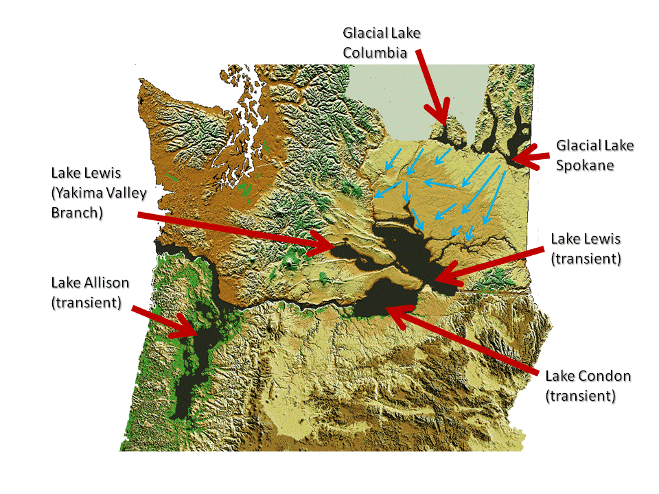
Lake Condon was a temporary lake in the Pacific Northwest
region of North America
, formed periodically by the Missoula Floods
from 15,000 to 13,000 BC.
The restricted flow of waters from cataclysmic floods from Glacial Lake Missoula
, and pluvial Lake Bonneville
through the constriction of the Wallula Gap
in the Horse Heaven Hills
flowed into south-central Washington) and north-central Oregon
, and were backed up by the Columbia River Gorge
, forming Lake Condon. The water remained for a period of 5-7 days before the flood waters drained through the Columbia River Gorge. Lake Condon reached an elevation of about 1200 feet above sea level (today's sea level) before subsiding.
Lake Condon also flooded the Umatilla
, and John Day
river valleys.
 During the last Ice Age (18,000 to 12,000 years ago), and in multiple previous Ice Ages, cataclysmic floods inundated portions of the Pacific Northwest from Glacial Lake Missoula
, pluvial
Lake Bonneville
, and perhaps from subglacial outbursts. Glacial Lake Missoula was a body of water as large as some of the USA's Great Lakes
. This lake formed from glacial meltwater that was dammed by a lobe of the Canadian ice sheet. Episodically, perhaps every 40 to 140 years, the waters of this huge lake forced its way past the ice dam, inundating parts of the Pacific Northwest. Eventually, the ice receded northward far enough that the dam did not reform, and the flooding episodes ceased.
when the Missoula Floods
cut the steep, dramatic walls that exist today. The gorge provided a hydraulic dam which backed waters up for days before it drained. This quick erosion left many layers of volcanic rock
exposed.
.
Pacific Northwest
The Pacific Northwest is a region in northwestern North America, bounded by the Pacific Ocean to the west and, loosely, by the Rocky Mountains on the east. Definitions of the region vary and there is no commonly agreed upon boundary, even among Pacific Northwesterners. A common concept of the...
region of North America
North America
North America is a continent wholly within the Northern Hemisphere and almost wholly within the Western Hemisphere. It is also considered a northern subcontinent of the Americas...
, formed periodically by the Missoula Floods
Missoula Floods
The Missoula Floods refer to the cataclysmic floods that swept periodically across eastern Washington and down the Columbia River Gorge at the end of the last ice age. The glacial flood events have been researched since the 1920s...
from 15,000 to 13,000 BC.
The restricted flow of waters from cataclysmic floods from Glacial Lake Missoula
Glacial Lake Missoula
Glacial Lake Missoula was a prehistoric proglacial lake in western Montana that existed periodically at the end of the last ice age between 15,000 and 13,000 years ago...
, and pluvial Lake Bonneville
Lake Bonneville
Lake Bonneville was a prehistoric pluvial lake that covered much of North America's Great Basin region. Most of the territory it covered was in present-day Utah, though parts of the lake extended into present-day Idaho and Nevada. Formed about 32,000 years ago, it existed until about 14,500 years...
through the constriction of the Wallula Gap
Wallula Gap
Wallula Gap is a large water gap of the Columbia River through basalt anticlines in the Columbia River Basin in the U.S. state of Washington, just south of the confluence of the Walla Walla and Columbia rivers...
in the Horse Heaven Hills
Horse Heaven Hills
The Horse Heaven Hills are a long range of high, rolling hills in Klickitat, Yakima, and Benton counties in Washington State located east of Satus Creek and west of the Columbia River between the Yakima River and the Wallula Gap. The hills are an anticline ridge in the Yakima fold belt formed by...
flowed into south-central Washington) and north-central Oregon
Oregon
Oregon is a state in the Pacific Northwest region of the United States. It is located on the Pacific coast, with Washington to the north, California to the south, Nevada on the southeast and Idaho to the east. The Columbia and Snake rivers delineate much of Oregon's northern and eastern...
, and were backed up by the Columbia River Gorge
Columbia River Gorge
The Columbia River Gorge is a canyon of the Columbia River in the Pacific Northwest of the United States. Up to deep, the canyon stretches for over as the river winds westward through the Cascade Range forming the boundary between the State of Washington to the north and Oregon to the south...
, forming Lake Condon. The water remained for a period of 5-7 days before the flood waters drained through the Columbia River Gorge. Lake Condon reached an elevation of about 1200 feet above sea level (today's sea level) before subsiding.
Lake Condon also flooded the Umatilla
Umatilla River
The Umatilla River is an tributary of the Columbia River in the U.S. state of Oregon. Draining a basin of , it enters the Columbia near the city of Umatilla in the northeastern part of the state...
, and John Day
John Day River
The John Day River is a tributary of the Columbia River, approximately long, in northeastern Oregon in the United States. Undammed along its entire length, the river is the third longest free-flowing river in the conterminous United States. There is extensive use of its waters for irrigation. Its...
river valleys.
Glacial Lake Missoula
Glacial Lake Missoula
Glacial Lake Missoula was a prehistoric proglacial lake in western Montana that existed periodically at the end of the last ice age between 15,000 and 13,000 years ago...
, pluvial
Pluvial lake
A pluvial lake is a landlocked basin which fills with rainwater during times of glaciation, when precipitation is higher. Pluvial lakes that have since evaporated and dried out may also be referred to as paleolakes.-Geology:...
Lake Bonneville
Lake Bonneville
Lake Bonneville was a prehistoric pluvial lake that covered much of North America's Great Basin region. Most of the territory it covered was in present-day Utah, though parts of the lake extended into present-day Idaho and Nevada. Formed about 32,000 years ago, it existed until about 14,500 years...
, and perhaps from subglacial outbursts. Glacial Lake Missoula was a body of water as large as some of the USA's Great Lakes
Great Lakes
The Great Lakes are a collection of freshwater lakes located in northeastern North America, on the Canada – United States border. Consisting of Lakes Superior, Michigan, Huron, Erie, and Ontario, they form the largest group of freshwater lakes on Earth by total surface, coming in second by volume...
. This lake formed from glacial meltwater that was dammed by a lobe of the Canadian ice sheet. Episodically, perhaps every 40 to 140 years, the waters of this huge lake forced its way past the ice dam, inundating parts of the Pacific Northwest. Eventually, the ice receded northward far enough that the dam did not reform, and the flooding episodes ceased.
Columbia River Gorge
Although the river slowly eroded the land over this period of time, the most drastic changes took place at the end of the last Ice AgeIce age
An ice age or, more precisely, glacial age, is a generic geological period of long-term reduction in the temperature of the Earth's surface and atmosphere, resulting in the presence or expansion of continental ice sheets, polar ice sheets and alpine glaciers...
when the Missoula Floods
Missoula Floods
The Missoula Floods refer to the cataclysmic floods that swept periodically across eastern Washington and down the Columbia River Gorge at the end of the last ice age. The glacial flood events have been researched since the 1920s...
cut the steep, dramatic walls that exist today. The gorge provided a hydraulic dam which backed waters up for days before it drained. This quick erosion left many layers of volcanic rock
Igneous rock
Igneous rock is one of the three main rock types, the others being sedimentary and metamorphic rock. Igneous rock is formed through the cooling and solidification of magma or lava...
exposed.
Touchet-like formation
Lake Condon backflooded into the Umatilla and John Day River Valleys. In these relatively calm arms of the lake, the slackwaters were thick with suspended materials eroded from the scablands above. Some of the suspended materials settled out, creating thick sediment layers which are found throughout these valleys.These sediment layers are part of the Touchet FormationTouchet Formation
The Touchet Formation or Touchet beds consist of large quantities of gravel and fine sediment which overlay almost a thousand meters of volcanic basalt of the Columbia River Basalt Group in south-central Washington and north-central Oregon...
.