

The Haven, Boston
Encyclopedia
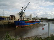
Port
A port is a location on a coast or shore containing one or more harbors where ships can dock and transfer people or cargo to or from land....
of Boston, Lincolnshire
Boston, Lincolnshire
Boston is a town and small port in Lincolnshire, on the east coast of England. It is the largest town of the wider Borough of Boston local government district and had a total population of 55,750 at the 2001 census...
in England
England
England is a country that is part of the United Kingdom. It shares land borders with Scotland to the north and Wales to the west; the Irish Sea is to the north west, the Celtic Sea to the south west, with the North Sea to the east and the English Channel to the south separating it from continental...
. It provides access for shipping
Shipping
Shipping has multiple meanings. It can be a physical process of transporting commodities and merchandise goods and cargo, by land, air, and sea. It also can describe the movement of objects by ship.Land or "ground" shipping can be by train or by truck...
between Boston Deeps in The Wash
The Wash
The Wash is the square-mouthed bay and estuary on the northwest margin of East Anglia on the east coast of England, where Norfolk meets Lincolnshire. It is among the largest estuaries in the United Kingdom...
and the town, particularly, the dock
Dock (maritime)
A dock is a human-made structure or group of structures involved in the handling of boats or ships, usually on or close to a shore.However, the exact meaning varies among different variants of the English language...
. It also serves as the outfall
Outfall
An outfall is the discharge point of a waste stream into a body of water; alternatively it may be the outlet of a river, drain or a sewer where it discharges into the sea, a lake or the like....
into the sea, of the River Witham
River Witham
The River Witham is a river, almost entirely in the county of Lincolnshire, in the east of England. It rises south of Grantham close to South Witham, at SK8818, passes Lincoln at SK9771 and at Boston, TF3244, flows into The Haven, a tidal arm of The Wash, near RSPB Frampton Marsh...
and of several major land drains
Drainage
Drainage is the natural or artificial removal of surface and sub-surface water from an area. Many agricultural soils need drainage to improve production or to manage water supplies.-Early history:...
of the northern Fens
The Fens
The Fens, also known as the , are a naturally marshy region in eastern England. Most of the fens were drained several centuries ago, resulting in a flat, damp, low-lying agricultural region....
of eastern England, which are known collectively as the Witham Navigable Drains
Witham Navigable Drains
The Witham Navigable Drains are located in Lincolnshire, England, and are part of a much larger drainage system managed by the Witham Fourth District Internal Drainage Board. In total there are over of drainage ditches, of which under are navigable...
. .
Physical and economic development
The English settlers who arrived in The Wash, found tidal creeks which gave them entry to the habitable belt of land, inland from the salt-marshesMarsh
In geography, a marsh, or morass, is a type of wetland that is subject to frequent or continuous flood. Typically the water is shallow and features grasses, rushes, reeds, typhas, sedges, other herbaceous plants, and moss....
. These creeks, they called "havens". There was a route inland from The Haven, with which this article deals, on which Boston later developed, to the upland of Lindsey
Lindsey
Lindsey was a unit of local government until 1974 in Lincolnshire, England, covering the northern part of the county. The Isle of Axholme, which is on the west side of the River Trent, has normally formed part of it...
. However, the port of Boston did not develop until after natural events had diverted the River Witham into The Haven during the eleventh century.
Simultaneously, this took the river away from Drayton, , which had become the successor port of Swineshead as its estuary accumulated silt. The Swin had been to Swineshead what the Zwin was to Bruges
Bruges
Bruges is the capital and largest city of the province of West Flanders in the Flemish Region of Belgium. It is located in the northwest of the country....
but after the loss of the Witham, Bicker became more important than Drayton so its estuary became known as Bicker Haven.
At the time of the Domesday Book
Domesday Book
Domesday Book , now held at The National Archives, Kew, Richmond upon Thames in South West London, is the record of the great survey of much of England and parts of Wales completed in 1086...
(1086) The accounting for Boston was still done under the heading of the manors of Drayton but the wealth of Drayton's holdings, as recorded in the Domesday Book, in Skirbeck
Skirbeck (wapentake)
Skirbeck Wapentake was an administrative unit in the Parts of Holland Lincolnshire, England from the early eleventh century at the latest, until the wapentakes were abolished by the Local Government Act of 1888....
makes the presence of a working port at Boston, which then lay in Skirbeck, near certain.
Before The Witham broke into it, The Haven's head was in the area which subsequently became the Market Place. The likely date for the switch of the Witham from Drayton to The Haven is 1014, the date recorded by the Anglo-Saxon Chronicle
Anglo-Saxon Chronicle
The Anglo-Saxon Chronicle is a collection of annals in Old English chronicling the history of the Anglo-Saxons. The original manuscript of the Chronicle was created late in the 9th century, probably in Wessex, during the reign of Alfred the Great...
as one of unprecedented sea floods. There was another serious flood, later in the century but that came after 1086.
Subsequently, Boston and its Haven became busy with trade as wool was brought into the town for export, particularly to Flanders
Flanders
Flanders is the community of the Flemings but also one of the institutions in Belgium, and a geographical region located in parts of present-day Belgium, France and the Netherlands. "Flanders" can also refer to the northern part of Belgium that contains Brussels, Bruges, Ghent and Antwerp...
.
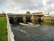
The modern port
There is a proposal to build a tidal barrage in the neighbourhood of the Black Sluice in order to reduce the incidence of flooding in the town and to manage boat access between the River Witham
River Witham
The River Witham is a river, almost entirely in the county of Lincolnshire, in the east of England. It rises south of Grantham close to South Witham, at SK8818, passes Lincoln at SK9771 and at Boston, TF3244, flows into The Haven, a tidal arm of The Wash, near RSPB Frampton Marsh...
and the South Forty-Foot Drain
South Forty-foot drain
The South Forty-Foot Drain is the main channel for the land-drainage of the Black Sluice Level in the Lincolnshire Fens. It lies in eastern England between Guthram Gowt and the Black Sluice pumping station on The Haven, at Boston...
. The work will be authorised by a Transport and Works Act 1992
Transport and Works Act 1992
The Transport and Works Act 1992 was established by the Parliament of the United Kingdom to provide a system by which the construction of rail transport, tramway, inland waterway and harbour infrastructure could proceed in the UK by order of the Minister of State for Transport rather than, as...
Order, and is expected to be completed by 2013. The Transport and Works Act (1992) was introduced to simplify the process of obtaining permission for the construction or alteration of railways and inland navigations, and any work which interferes with rights of navigation.
Historical connection
In 1607, The Haven, between Boston and the sea , was the scene of the first, abortive, attempt of the ScroobyScrooby
Scrooby is a small village, on the River Ryton and near Bawtry, in the northern part of the English county of Nottinghamshire. At the time of the 2001 census it had a population of 329. Until 1766, it was on the Great North Road so became a stopping-off point for numerous important figures...
Pilgrims, to leave England. Ultimately, in 1620, they became part of the original settlement of Plymouth, Massachusetts. See Pilgrim Fathers Memorial
Pilgrim Fathers Memorial
The Pilgrim Fathers Memorial is located on the north bank of The Haven at the site of the former Scotia Creek, Fishtoft, seaward of Boston in Lincolnshire, England, and consists of a small granite obelisk mounted on a granite block...
.
See also
- Canals of the United KingdomCanals of the United KingdomThe canals of the United Kingdom are a major part of the network of inland waterways in the United Kingdom. They have a colourful history, from use for irrigation and transport, through becoming the focus of the Industrial Revolution, to today's role for recreational boating...
- History of the British canal systemHistory of the British canal systemThe British canal system of water transport played a vital role in the United Kingdom's Industrial Revolution at a time when roads were only just emerging from the medieval mud and long trains of pack horses were the only means of "mass" transit by road of raw materials and finished products The...
External links
- Flood warning status
- Terraserver aerial photograph The North is to the top, Boston is to the West and the coast meets the edge of the picture at FreistonFreistonFreiston is a village and civil parish in Lincolnshire, England, about east of Boston.It is one of 18 civil parishes which, together with Boston, form the Borough of Boston local government arrangement, in place since a reorganisation of 1 April 1974 which resulted from the Local...
Shore. The mouth of the River Welland is to the south-west. The Haven joins Skirbeck to The Wash and is joined by the Hobhole Drain from the north.