
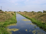
South Forty-foot drain
Encyclopedia

Lincolnshire
Lincolnshire is a county in the east of England. It borders Norfolk to the south east, Cambridgeshire to the south, Rutland to the south west, Leicestershire and Nottinghamshire to the west, South Yorkshire to the north west, and the East Riding of Yorkshire to the north. It also borders...
Fens
The Fens
The Fens, also known as the , are a naturally marshy region in eastern England. Most of the fens were drained several centuries ago, resulting in a flat, damp, low-lying agricultural region....
. It lies in eastern England
England
England is a country that is part of the United Kingdom. It shares land borders with Scotland to the north and Wales to the west; the Irish Sea is to the north west, the Celtic Sea to the south west, with the North Sea to the east and the English Channel to the south separating it from continental...
between Guthram Gowt
Guthram Gowt
Guthram Gowt is a small settlement between Bourne and Spalding in Lincolnshire, England, at a bend in the River Glen.-The Location:Guthram Gowt is at the southern, upstream end of the South Forty-Foot Drain...
and the Black Sluice pumping station on The Haven
The Haven, Boston
The Haven is the tidal river of the Port of Boston, Lincolnshire in England. It provides access for shipping between Boston Deeps in The Wash and the town, particularly, the dock. It also serves as the outfall into the sea, of the River Witham and of several major land drains of the northern Fens...
, at Boston
Boston, Lincolnshire
Boston is a town and small port in Lincolnshire, on the east coast of England. It is the largest town of the wider Borough of Boston local government district and had a total population of 55,750 at the 2001 census...
. The Drain has its origins in the 1630s, when the first scheme to make the Fen land available for agriculture was carried out by the Earl of Lindsay, and has been steadily improved since then. Water drained from the land entered The Haven by gravity at certain states of the tide until 1946, when the Black Sluice pumping station was commissioned.
The Drain was navigable until 1971, when improvements to the pumping station led to the entrance lock being removed. It is currently being upgraded to navigable status by the Environment Agency
Environment Agency
The Environment Agency is a British non-departmental public body of the Department for Environment, Food and Rural Affairs and an Assembly Government Sponsored Body of the Welsh Assembly Government that serves England and Wales.-Purpose:...
, as part of the Fens Waterways Link
Fens Waterways Link
The Fens Waterways Link is a project to improve recreational boating opportunities in the counties of Cambridgeshire and Lincolnshire, England. By a combination of improvements to existing waterways and the construction of new links a circular route between Lincoln, Peterborough, Ely and Boston is...
, with a new entrance lock being completed in December 2008, giving access to the first 12 miles (19.3 km) of the drain, and the upgrading of the southern section, including a link to the River Glen
River Glen, Lincolnshire
The River Glen is a river in Lincolnshire, England with a short stretch passing through Rutland near Essendine.The river's name appears to derive from a Brythonic Celtic language but there is a strong early English connection.-Naming:...
to allow navigation to Spalding
Spalding, Lincolnshire
Spalding is a market town with a population of 30,000 on the River Welland in the South Holland district of Lincolnshire, England. Little London is a hamlet directly south of Spalding on the B1172 road....
forming phase 2 of the project.
History
The Lincolnshire Fens are an area of low-lying land which have been subject to flooding and attempts to prevent it for centuries. In medieval times, the Midfen Dyke was built to drain the area, but by 1500, this was regarded less as a drain for the land than as a boundary markerBoundary marker
A boundary marker, boundary stone or border stone is a robust physical marker that identifies the start of a land boundary or the change in a boundary, especially a change in a direction of a boundary...
between the Parts of Holland
Holland, Lincolnshire
Holland is an area of south-east Lincolnshire, England. The name is still recognised locally and survives in the district of South Holland.-Administration:...
and the Parts of Kesteven, two of the three medieval subdivisions of Lincolnshire which functioned as county councils until their abolition in 1974. The first serious attempt to drain the area to the south west of Boston
Boston, Lincolnshire
Boston is a town and small port in Lincolnshire, on the east coast of England. It is the largest town of the wider Borough of Boston local government district and had a total population of 55,750 at the 2001 census...
, now known as the Black Sluice Area but formerly known as the Lindsay Level, was from 1635 to 1638, when the Earl of Lindsay
Robert Bertie, 1st Earl of Lindsey
Robert Bertie, 1st Earl of Lindsey was an English peer, soldier and courtier.-Early life:...
agreed with the Commissioners of Sewers for Lincolnshire to carry out drainage works which would make 36000 acres (145.7 km²) of land available for agricultural use. The Earl and his colleagues paid for the works, in return for land grants.
The cost of the work was £45,000, and involved the construction of a sluice near Boston, called Skirbeck Sluice, the construction of the first 8 miles (12.9 km) of the South Forty-Foot Drain, from Boston to Great Hale
Great Hale
Great Hale is a village and civil parish in the North Kesteven district of Lincolnshire, England. It lies on the B1394 road, immediately south of Heckington and north of Helpringham.-History:...
, the construction of two drains from there to Guthram, which were called the Double Twelves, and the construction of the Clay Dyke Drain. The scheme was not popular with local landowners, who destroyed much of the work and burnt the Skirbeck Sluice. The Earl of Lindsay's contract with the Commissioners of Sewers was revoked by parliament, and it was another hundred years before the next attempt to drain the area.
In an attempt to drain Holland Fen, and prevent flooding from the River Witham
River Witham
The River Witham is a river, almost entirely in the county of Lincolnshire, in the east of England. It rises south of Grantham close to South Witham, at SK8818, passes Lincoln at SK9771 and at Boston, TF3244, flows into The Haven, a tidal arm of The Wash, near RSPB Frampton Marsh...
, an adventurer called Earl Fitzwilliam constructed a drain in 1720, which runs broadly parallel to the River Witham, and terminated at Lodewick's Gowt, a sluice which he constructed on the Witham close to the location of the present Grand Sluice. The drain was for many years called Earl Fitzwilliam's drain, but is now called the North Forty-Foot Drain. The scheme was not entirely successful.
Second Sluice
In 1762, the Witham Drainage Act was passed by Parliament, and among other things constituted the Commissioners of Sewers for the Second and Sixth District, which covered the area including AsgarbyAsgarby, Sleaford
Asgarby is a hamlet in the civil parish of Asgarby and Howell, in the North Kesteven district of Lincolnshire, England. It lies on the A17 Boston to Newark road, east of Sleaford and 2 miles west of Heckington....
, Ewerby
Ewerby
Ewerby is a village in the North Kesteven district of Lincolnshire, England. It lies north-east from Sleaford and south from Anwick. The hamlet of Ewerby Thorpe lies to the east from Ewerby....
, Great Hale, Heckington
Heckington
Heckington is a village and civil parish in the North Kesteven district of Lincolnshire, England. It lies between Sleaford and Swineshead Bridge, south of the A17 road. Heckington, with 1491 households, is one of the largest villages in Lincolnshire.-History:...
, Holland Fen, Howell
Howell, Lincolnshire
Howell is a very small hamlet near Ewerby in North Kesteven, Lincolnshire, overlooking Haverholme Priory just north of the A17.It is in the parish of Asgarby and Howell. The parish is dedicated to St Oswald, and with Asgarby and South Kyme is in the Heckington group of churches.-References:...
, Little Hale
Little Hale
Little Hale is a hamlet and civil parish of around 60 houses located directly south of the larger villages of Great Hale and Heckington, 5 miles from the town of Sleaford in Lincolnshire. Little Hale is located on the eastern western edge of the Lincolnshire Fens...
and South Kyme. Much of the area to the south and west of Boston, some 91 square miles (235.7 km²), was inundated by the Great Flood of 1763, and against this background, the Black Sluice Drainage and Navigation Act 1765 was obtained which created the Black Sluice Commissioners, giving them power to raise taxes and authority to carry out drainage works. The scheme largely revived the Earl of Lindsay's original scheme. The initial design work was carried out by the civil engineer Langley Edwards, on loan from the Witham Commissioners. Some of the surveying was performed by John Landen, who was the steward of the estate of Earl Fitzwilliam at Peterborough, and a proficient amateur mathematician. The two men were jointly appointed Surveyors of the Works, acting as engineers for the scheme, while John Chapman and Richard Strattard were assistants. A new sluice
Sluice
A sluice is a water channel that is controlled at its head by a gate . For example, a millrace is a sluice that channels water toward a water mill...
, called the Black Sluice, was built at Boston as a direct replacement for the Skirbeck Sluice, having three openings with a total width of 40 feet (12.2 m). The 8 miles (12,874.7 m) of the drain were scoured from Boston to Great Hale, beyond which the Main Drain was upgraded by cutting a new 14 miles (22.5 km) channel, effectively extending the South Forth-Foot Drain to Guthram, on the banks of the River Glen
River Glen
There are at least five rivers called Glen:*River Glen, Lincolnshire, England*River Glen, Northumberland, England*Glen Water, Ayrshire, Scotland*Glen River, Quebec, Canada*Glen River, County Cork, Ireland*Glen River, County Donegal, Ireland...
. A total of 65 miles (104.6 km) of highland streams were improved by scouring and raising of the banks. The estimated cost of £16,000 was raised by issuing bonds, but the project overran, and another Act of Parliament was obtained in 1770 to authorise the raising of the drainage taxes, to cover the difference. By mid-1769, when Landen and Edwards left the project, because the work was largely complete, the scheme had cost £24,000. They were replaced by Edward Hare as Surveyor of Works, with Chapman and Strattard continuing as assistants. A historian called W. H. Wheeler, who chronicled the Lincolnshire fens, wrote that "the works were efficintly carried out and, being well-designed, entirely answered expectation."
On the River Witham
River Witham
The River Witham is a river, almost entirely in the county of Lincolnshire, in the east of England. It rises south of Grantham close to South Witham, at SK8818, passes Lincoln at SK9771 and at Boston, TF3244, flows into The Haven, a tidal arm of The Wash, near RSPB Frampton Marsh...
, the Grand Sluice was constructed and opened on 15 October 1766, and this prevented tidal water from entering the river, and hence flooding the Holland Fen. The Boston Harbour Commissioners were created by the Boston Port Act 1766, and they carried out improvement works to The Haven
The Haven, Boston
The Haven is the tidal river of the Port of Boston, Lincolnshire in England. It provides access for shipping between Boston Deeps in The Wash and the town, particularly, the dock. It also serves as the outfall into the sea, of the River Witham and of several major land drains of the northern Fens...
, which resulted in lower water levels at the Black Sluice, and hence more efficient draining from the South Forty-Foot Drain. Water was pumped into the drain by a series of windmills driving scoop wheels. Maps of the area produced in 1783 by Edward Hare show 46 such mills, which provided drainage for 32000 acres (129.5 km²) of agricultural land. Extreme high tides in 1810 and again in 1820 resulted in widespread flooding, and further thought was given to improving the flood defences.
With the improvements to the River Witham, the final section of Earl Fitzwilliam's drain to Lodewick Gowt was filled in, and the channel was diverted to join the South Forty-Foot Drain. Renamed the North Forty-Foot Drain, it now supplies Cooks Lock and Holland Fen pumping stations.
Third Sluice
Reports on improvements to the system were produced in 1843 by the surveyor Mr W Lewin and in 1845 by Sir John Rennie. Rennie's scheme involved the provision of a catchwater drainCatchwater drain
A catchwater drain is a land drain, a ditch cut across the fall of the land, typically just above the level of low-lying, level ground such as The Fens of eastern England, where some land, tens of kilometres from the sea is at about sea level...
to collect water draining from the higher ground to the west before it entered the fenlands, but an Act of Parliament to authorise its construction was defeated, and so in 1846 a report by Mr W Cubit which proposed improvements to the existing infrastructure was accepted by the Commissioners. A new Black Sluice, including a 20 feet (6.1 m) wide navigation lock, was constructed to the south of the original one, with the cill level 6 feet (1.8 m) lower, which enabled the gradient of the South Forty-Foot Drain to be increased to 3 inches per mile (5 cm/km). Many of the tributary drains were also improved. 1846 also marked the beginning of the use of steam engines for pumping. Ten years later, a map covering 18000 acres (72.8 km²) of the Black Sluice area showed nine steam-powered and eight wind-powered drainage engines in use.
The River Witham Outfall Improvement Act 1880 authorised further improvements to the mouth of the Witham, to which the Black Sluice Commissioners contributed £65,000. This work led to a further drop of 4 feet (1.2 m) in the low water level at the Black Sluice. Oil and paraffin
Paraffin
In chemistry, paraffin is a term that can be used synonymously with "alkane", indicating hydrocarbons with the general formula CnH2n+2. Paraffin wax refers to a mixture of alkanes that falls within the 20 ≤ n ≤ 40 range; they are found in the solid state at room temperature and begin to enter the...
engines began to replace steam and wind engines from 1910, and by 1935 there were 15 such engines pumping water into the South Forty-Foot Drain. The passing of the Land Drainage Act 1930 resulted in the Commissioners being replaced by the Black Sluice Internal Drainage Board
Internal Drainage Board
An internal drainage board is a type of operating authority which is established in areas of special drainage need in England and Wales with permissive powers to undertake work to secure clean water drainage and water level management within drainage districts...
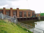
, while responsibility for the rivers in the area passed to the Witham and Steeping Rivers Catchment Board. With war imminent, the Rivers Board took over the Black Sluice and the South Forty-Foot Drain in 1939, and although progress was interrupted by the Second World War, a £374,000 scheme to construct the Black Sluice pumping station and to widen 11 miles (17.7 km) of the drain from Boston to Donington Bridge was completed in 1946. The pumping station contained three 100 inches (2.5 m) pumps, each powered by a 900 hp 5-cylinder vertical diesel engine manufactured by Ruston
Ruston (engine builder)
Ruston & Hornsby, later known as Ruston, was an industrial equipment manufacturer in Lincoln, England, the company's history going back to 1840. The company is best known as a manufacturer of narrow and standard gauge diesel locomotives and also of steam shovels. Other products included cars, steam...
.
Modern era
Paraffin and oil engines gave way to electrically powered pumping stations in the 1950s, with the Board constructing six electric and one diesel pumping station to improve drainage to an extra 11000 acres (44.5 km²) of land. In 1960, the decision was taken to further improve drainage of an area of 70000 acres (283.3 km²), as part of a £1.4 million scheme which included the addition of two extra pumps at the Black Sluice, replacement of existing pumps elsewhere, and the widening of 7 miles (11.3 km) of the South Forty-Foot Drain from Donington Bridge to Rippingale Running Dyke. Jurisdiction for the Drain and the sluice passed to the Lincolnshire River Board at this time. The work, which began in 1962 and was completed in 1968, proved successful in preventing flooding during severe wet weather in the winter of 1968/9. With three 900 hp and two 925 hp diesel engines, the upgraded pumping station can pump 800 thousand gallons per minute (60 m3/s). Responsibility for the drain and the sluice passed to the National Rivers AuthorityNational Rivers Authority
The National Rivers Authority was one of the forerunners of the Environment Agency of England and Wales, existing between 1989 and 1996. Before 1989 the regulation of the aquatic environment had largely been carried out by the ten Regional Water Authorities...
in 1990, and to the Environment Agency
Environment Agency
The Environment Agency is a British non-departmental public body of the Department for Environment, Food and Rural Affairs and an Assembly Government Sponsored Body of the Welsh Assembly Government that serves England and Wales.-Purpose:...
in 1995.
Despite all the improvements, serious flooding occurred in 1999 when the bank of the drain was breached near Pinchbeck. Staff from the Environment Agency and the Black Sluice Internal Drainage Board successfully repaired the breach before properties were flooded, and a review of the flood defences was then carried out. The report recommended improvements to some of the banks, but funding for the work was not available, and so no work was done at the time.
Functions
South Kesteven
South Kesteven is a local government district in Lincolnshire, England, forming part of the traditional Kesteven division of the county. It covers Grantham, Stamford, Bourne and Market Deeping.-History:...
to the west from South Holland
South Holland, Lincolnshire
South Holland is a local government district of Lincolnshire. The district council is based in Spalding.It was formed on 1 April 1974, under the Local Government Act 1972, as a merger of the Spalding urban district with East Elloe Rural District and Spalding Rural District...
to the east. The boundary then continues southwards along the River Glen. North of Donington, the boundary between the borough of Boston
Boston (borough)
Boston is a local government district with borough status in Lincolnshire, England. Its council is based in the town of Boston. It lies around N53°0'0" W0°0'0"....
to the east and North Kesteven
North Kesteven
North Kesteven is a local government district in the East Midlands. Just over north of London, it is east of Nottingham and south of Lincoln. North Kesteven is one of seven districts in Lincolnshire, England and is in the centre of the County...
to the west follows the line of the Drain. As the Drain crosses the line of the Midfen Dyke, just before the Nottingham to Boston railway
Great Northern Railway (Great Britain)
The Great Northern Railway was a British railway company established by the Great Northern Railway Act of 1846. On 1 January 1923 the company lost its identity as a constituent of the newly formed London and North Eastern Railway....
joins it at Great Hale pumping station, the boundary turns northwards, following its medieval course.
The main job of the Drain is to gather the waters pumped from the Kesteven Fens, the Holland Fens and the Weir Dyke, a soak dike
Soak dike
The term Soak dike is used in The Fens of eastern England to mean a ditch or drain running parallel with an embankment, for the purpose of taking any water that soaks through from the river or drain beyond the bank...
in Bourne North Fen, alongside the Bourne Eau
Bourne Eau
Bourne Eau is a short river which rises in the town of Bourne in Lincolnshire, England, and flows in an easterly direction to join the River Glen at Tongue End. It is an embanked river, as its normal level is higher than that of the surrounding Fens...
and River Glen
River Glen, Lincolnshire
The River Glen is a river in Lincolnshire, England with a short stretch passing through Rutland near Essendine.The river's name appears to derive from a Brythonic Celtic language but there is a strong early English connection.-Naming:...
, northwards and eastwards to the Black Sluice at Boston, where they are discharged to the tidal waters of The Haven. The Weir Dyke takes its name from a weir
Weir
A weir is a small overflow dam used to alter the flow characteristics of a river or stream. In most cases weirs take the form of a barrier across the river that causes water to pool behind the structure , but allows water to flow over the top...
in the bank of the Bourne Eau at Tongue End, which was constructed by the Black Sluice Commissioners, to allow water from the Bourne Eau to overflow the bank when excess water could not flow into the River Glen in times of flood. The overfall weir became redundant when the Tongue End pumping station was constructed in 1966.
The South Forty-Foot Drain and the Black Sluice pumping station, together with most of the side channels which run into the drain are the responsibility of the Environment Agency. Management of the drainage ditches which drain the Fens are the responsibility of the Black Sluice Internal Drainage Board, who maintain 34 pumping stations and three gravity stations in the region. Of these, 21 are situated on the banks of the Drain, and pump directly into it, while one, the Black Hole Drove pumping station, is constructed over the channel, and acts as a boundary between the part of the Drain managed by the Environment Agency, and that managed by the Drainage Board.
Navigation
East Anglian Waterways Association
The East Anglian Waterways Association is a waterway society and an umbrella organisation in East Anglia, England, UK.The association was founded on 18 April 1958, and it campaigns for the preservation, restoration and good management of the tidal and inland waterways in East Anglia...
promoted the idea that the Drain could again be made navigable as part of a larger scheme to improve leisure facilities. The local authorities which were part of the Fens Tourism consortium conducted a feasibility study, and this report was formally adopted as the Fens Waterways Link
Fens Waterways Link
The Fens Waterways Link is a project to improve recreational boating opportunities in the counties of Cambridgeshire and Lincolnshire, England. By a combination of improvements to existing waterways and the construction of new links a circular route between Lincoln, Peterborough, Ely and Boston is...
by the Environment Agency in 2004, with the support of the local authorities, the East Anglian Waterways Association and the Inland Waterways Association
Inland Waterways Association
The Inland Waterways Association was formed in 1946 as a registered charity in the United Kingdom to campaign for the conservation, use, maintenance, restoration and sensitive development of British Canals and river navigations....
.
The scheme involves a total of 150 miles (241.4 km) of waterway, of which 50 miles (80.5 km) will be new cruiseway, while the rest will be existing waterways which will be upgraded or have their access improved. When completed, it will connect the Rivers Witham
River Witham
The River Witham is a river, almost entirely in the county of Lincolnshire, in the east of England. It rises south of Grantham close to South Witham, at SK8818, passes Lincoln at SK9771 and at Boston, TF3244, flows into The Haven, a tidal arm of The Wash, near RSPB Frampton Marsh...
, Glen, Welland
River Welland
The River Welland is a river in the east of England, some long. It rises in the Hothorpe Hills, at Sibbertoft in Northamptonshire, then flows generally northeast to Market Harborough, Stamford and Spalding, to reach The Wash near Fosdyke. For much of its length it forms the county boundary between...
, Nene
River Nene
The River Nene is a river in the east of England that rises from three sources in the county of Northamptonshire. The tidal river forms the border between Cambridgeshire and Norfolk for about . It is the tenth longest river in the United Kingdom, and is navigable for from Northampton to The...
and Great Ouse
River Great Ouse
The Great Ouse is a river in the east of England. At long, it is the fourth-longest river in the United Kingdom. The river has been important for navigation, and for draining the low-lying region through which it flows. Its course has been modified several times, with the first recorded being in...
, and is being heralded as the biggest waterway enhancement project in Europe by the Environment Agency
Environment Agency
The Environment Agency is a British non-departmental public body of the Department for Environment, Food and Rural Affairs and an Assembly Government Sponsored Body of the Welsh Assembly Government that serves England and Wales.-Purpose:...
.
In 2007 they obtained funding for the link between Boston and Spalding
Spalding, Lincolnshire
Spalding is a market town with a population of 30,000 on the River Welland in the South Holland district of Lincolnshire, England. Little London is a hamlet directly south of Spalding on the B1172 road....
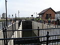
. Work on a new lock beside the Black Sluice pumping station at Boston
Boston, Lincolnshire
Boston is a town and small port in Lincolnshire, on the east coast of England. It is the largest town of the wider Borough of Boston local government district and had a total population of 55,750 at the 2001 census...
- to connect The Haven and the South Forty-Foot Drain - was formally started on 8 February 2008, and was completed in December 2008, with the official opening ceremony being held on 20 March 2009. The lock project formed phase 1 of the scheme, and the cost of £8.5 million was jointly funded by the European Regional Development Fund, the East Midlands Development Agency, and Lincolnshire County Council. The lock is designed to be used for a period either side of high tide, and so there is a rise from the Drain to the Haven. It has conventional mitre gates at one end, but uses rotating sector gates at the tidal end, each one weighing 12.1 tonnes.
The lock opens up nearly 12 miles (19.3 km) of waterway. As part of the upgrade, new 48-hour moorings have been constructed on The Haven, for boats about to enter the Drain, and on the South Forty-Foot Drain near the Black Sluice pumping station at Boston, at Swineshead Bridge and at Hubbert's Bridge.
The upper limit of navigation is initially Donington High Bridge, at which the Swaton Eau joins the South Forty-Foot Drain and provides a wider section where boats can be turned. Beyond the bridge, the drain is officially only suitable for canoes and kayaks.
However, eight narrow boats cruised on the waterway at Easter 2009, and although the channel is narrower and not as deep after Donington Bridge, all of the boats successfully reached Kingston's Bridge, some 3.7 miles (6 km) further on, where the outlets from Dowsby Fen and Gosberton pumping stations provide enough width to turn a 70 feet (21.3 m) boat. Further progress was blocked by scaffolding erected so that the bridge could be re-decked, rather than by lack of water.
The drain has been renamed as the Black Sluice Navigation by the Environment Agency. In order to use the navigation, an Environment Agency licence is required, and as there are no permanent moorings available on the drain, these are available for one day or seven days.
Water levels are maintained at a lower level during the winter months, when flows are high, and the Drain needs to be able to cope with higher volumes of rainfall, than during the summer months, when navigable levels are maintained. As on the neighbouring River Witham
River Witham
The River Witham is a river, almost entirely in the county of Lincolnshire, in the east of England. It rises south of Grantham close to South Witham, at SK8818, passes Lincoln at SK9771 and at Boston, TF3244, flows into The Haven, a tidal arm of The Wash, near RSPB Frampton Marsh...
, the switch between winter and summer levels is normally made at the beginning of April.
Phase 2 of the Fens Waterway project involves the link between Donington Bridge and Crowland and Cowbit Washes, which are located on the River Welland
River Welland
The River Welland is a river in the east of England, some long. It rises in the Hothorpe Hills, at Sibbertoft in Northamptonshire, then flows generally northeast to Market Harborough, Stamford and Spalding, to reach The Wash near Fosdyke. For much of its length it forms the county boundary between...
near Spalding
Spalding, Lincolnshire
Spalding is a market town with a population of 30,000 on the River Welland in the South Holland district of Lincolnshire, England. Little London is a hamlet directly south of Spalding on the B1172 road....
. In order to make the financing of the phase more viable, it has been split into two halves, with phase 2a covering the section from Donington to Surfleet Seas End on the River Glen
River Glen, Lincolnshire
The River Glen is a river in Lincolnshire, England with a short stretch passing through Rutland near Essendine.The river's name appears to derive from a Brythonic Celtic language but there is a strong early English connection.-Naming:...
, and phase 2b covering from there onwards. The initial technical assessment and obtaining of planning permission for phase 2, which involves widening of the South Forty-Foot Drain from Donington to a new road crossing under the A151, a new lock and a junction with the River Glen at Guthram Gowt was funded by the East Midlands Development Agency. This section will also involve changes at Black Hole Drove pumping station, which has been built across the drain and hence would prevent navigation. Major contracts for this phase were expected to be awarded in April 2009, but appraisal of the technical assessment revealed that more than one route needed to be considered before the best solution could be selected. While the obvious solution would be to connect the Glen and the drain where they are only a short distance apart, the Lincolnshire Waterways Partnership have also considered the creation of new channels up to 9.3 miles (15 km) long to form the link. In the meantime, the economic situation changed, so that sources of funding were not so freely available, and by the end of 2010, no clear dates had been set for the next construction phase.
Precursors
The idea of a link between the South Forty-Foot Drain and the River Nene is not new, as the first plans for such a connection were proposed in 1809. In that year, proposals for a new canal between the Oakham CanalOakham Canal
The Oakham Canal ran from Oakham, Rutland to Melton Mowbray, Leicestershire in the East Midlands of England. It opened in 1802, but it was never a financial success, and it suffered from the lack of an adequate water supply. It closed after 45 years, when it was bought by the Midland Railway to...
at Oakham
Oakham
-Oakham's horseshoes:Traditionally, members of royalty and peers of the realm who visited or passed through the town had to pay a forfeit in the form of a horseshoe...
and the Stamford Canal
Stamford Canal
-New plans:The river Welland is not currently navigable above Crowland but plans for the Fens Waterways Link include a new link upstream of here to above the Dog in a doublet sluice on the River Nene. There are currently no plans to restore navigation to Stamford....
at Stamford
Stamford, Lincolnshire
Stamford is a town and civil parish within the South Kesteven district of the county of Lincolnshire, England. It is approximately to the north of London, on the east side of the A1 road to York and Edinburgh and on the River Welland...
, which had been discussed in 1785, were revived, as part of a larger plan for a 7 miles (11.3 km) link from Stamford to the River Nene at Peterborough, and a connection from near Market Deeping
Market Deeping
Market Deeping is a market town in Lincolnshire, England, on the north bank of the River Welland and the A15 road.-Geography:It is the second largest of The Deepings and its eponymous market has been held since at least 1220. The river here forms the Lincolnshire/Cambridgeshire border with...
, where the Stamford Canal rejoined the River Welland
River Welland
The River Welland is a river in the east of England, some long. It rises in the Hothorpe Hills, at Sibbertoft in Northamptonshire, then flows generally northeast to Market Harborough, Stamford and Spalding, to reach The Wash near Fosdyke. For much of its length it forms the county boundary between...
, northwards to the South Forty-Foot Drain. A bill for this, together with one for a rival scheme to link Stamford to the Grand Junction Canal
Grand Junction Canal
The Grand Junction Canal is a canal in England from Braunston in Northamptonshire to the River Thames at Brentford, with a number of branches. The mainline was built between 1793 and 1805, to improve the route from the Midlands to London, by-passing the upper reaches of the River Thames near Oxford...
, which also included a connection to the South Forty-Foot Drain, were put before Parliament in 1811, but neither met with any success. The idea was raised again in 1815 and 1828, but no further action was taken.
Route
See also
- Canals of Great Britain
- History of the British canal systemHistory of the British canal systemThe British canal system of water transport played a vital role in the United Kingdom's Industrial Revolution at a time when roads were only just emerging from the medieval mud and long trains of pack horses were the only means of "mass" transit by road of raw materials and finished products The...
- Fens Waterways LinkFens Waterways LinkThe Fens Waterways Link is a project to improve recreational boating opportunities in the counties of Cambridgeshire and Lincolnshire, England. By a combination of improvements to existing waterways and the construction of new links a circular route between Lincoln, Peterborough, Ely and Boston is...