
Amphoe Phrasaeng
Encyclopedia
Phraseang is a district (amphoe
) of Surat Thani Province
, Thailand
.
, Khian Sa
, Wiang Sa
of Surat Thani Province, Tham Phannara
, Thung Yai
of Nakhon Si Thammarat Province
, Chai Buri
of Surat Thani Province again, Khao Phanom
and Plai Phraya
of Krabi Province
.
At the boundary to Plai Phraya is the Khlong Phraya Wildlife Sanctuary
.
. The following year it and neighboring Amphoe I-Pan were reduced to a tambon and put under the control of Amphoe Lamphun (the present-day Amphoe Ban Na San
). In 1899 the monthon administrator Phraya Sukhumnaiwinit (Pan Sukhum) visited the area and noticed that Amphoe Lamphun was too large to administrate the area efficiently, and recreated the Phrasaeng district consisting of the tambon Phrasaeng and I-Pan. In 1906 the district was transferred to Mueang Chaiya, which is now Surat Thani Province.
Around 1940 a new district office in Ban Yan Din Daeng was built, as the old location in Ban Sai Khueng was not comfortable to reach for all of the population. Also on August 1, 1938 the district was reduced in status to a minor district (King Amphoe). It was upgraded back to full district status in 1958.
1968 King Bhumipol and his family made a royal visit to the district. On that occasion the King donated a Caterpillar
D4 bulldozer to the community, to help the development of the area.
), which are further subdivided into 74 villages (muban
). There are two subdistrict municipalities (thesaban tambon) - Bang Sawan covers parts of tambon Bang Sawan, and Yan Din Daeng parts of tambon I-pan. There are further 7 Tambon administrative organizations (TAO), responsible for the non-municipal areas.
Amphoe
An amphoe is the second level administrative subdivision of Thailand. Usually translated as district, amphoe make up the provinces, and are analogous to a county seat...
) of Surat Thani Province
Surat Thani Province
Surat Thani is the largest of the southern provinces of Thailand, on the eastern shore of the Gulf of Thailand. Surat Thani means City of Good People, the title given to the city by King Vajiravudh ....
, Thailand
Thailand
Thailand , officially the Kingdom of Thailand , formerly known as Siam , is a country located at the centre of the Indochina peninsula and Southeast Asia. It is bordered to the north by Burma and Laos, to the east by Laos and Cambodia, to the south by the Gulf of Thailand and Malaysia, and to the...
.
Geography
The district is located in the south of the province. Neighboring districts are (from north clockwise) PhanomAmphoe Phanom
Phanom is a district in the southwest of Surat Thani Province of southern Thailand.-Geography:The district is located within the hills of the Phuket mountain range, with around 60% of the area consisting of mountains and forests. The northwestern part of the district is protected in the Khao Sok...
, Khian Sa
Amphoe Khian Sa
Khian Sa is a district in Surat Thani Province, Thailand.Neighboring districts are Khiri Rat Nikhom, Phunphin, Ban Na Doem, Ban Na San, Wiang Sa, Phrasaeng and Phanom...
, Wiang Sa
Amphoe Wiang Sa, Surat Thani Province
-Geography:Wiang Sa is located in the southeast of Surat Thani province. Neighboring district are Phrasaeng, Khian Sa and Ban Na San of Surat Thani, and Phipun, Chawang and Tham Phannara of Nakhon Si Thammarat Province....
of Surat Thani Province, Tham Phannara
Amphoe Tham Phannara
Tham Phannara is a district of Nakhon Si Thammarat Province, southern Thailand.-Geography:Neighboring districts are Chawang and Thung Yai of Nakhon Si Thammarat, and Phrasaeng and Wiang Sa of Surat Thani Province....
, Thung Yai
Amphoe Thung Yai
Thung Yai is the westernmost district of Nakhon Si Thammarat Province, southern Thailand.-History:Tambon Ku Rae was separated from Thung Song district and made the minor district Ku Rae in 1906. When the office was moved to Tambon Tha Yang in 1909, the minor district was renamed following the...
of Nakhon Si Thammarat Province
Nakhon Si Thammarat Province
Nakhon Si Thammarat is one of the southern provinces of Thailand, at the eastern shore of the Gulf of Thailand...
, Chai Buri
Amphoe Chai Buri
-Geography:The district is located in the south of the province. The main river is the Khlong Thorom, which crosses the district from south to north....
of Surat Thani Province again, Khao Phanom
Amphoe Khao Phanom
-History:The minor district was created on December 1 1967 by adding together the tambon Khao Phanom, Khao Din and 2 villages of Khok Yang of Mueang Krabi district and tambon Sin Pun from Khlong Thom...
and Plai Phraya
Amphoe Plai Phraya
-Geography:Neighboring districts are Phanom, Phrasaeng, Chai Buri , Khao Phanom and Ao Luek of Krabi Province, and Thap Put of Phang Nga Province....
of Krabi Province
Krabi Province
Krabi is one of the southern provinces of Thailand, at the shore of the Andaman Sea. Neighbouring provinces are Phang Nga, Surat Thani, Nakhon Si Thammarat and Trang. The Phuket province to the west is also neighbouring, but without any land boundary...
.
At the boundary to Plai Phraya is the Khlong Phraya Wildlife Sanctuary
Khlong Phraya Wildlife Sanctuary
Khlong Phraya is a wildlife sanctuary in southern Thailand, located at the boundary of Surat Thani and Krabi Province.It covers an area of 153.6 km² of the districts Plai Phraya, Phrasaeng and Chai Buri...
.
History
The district was first established in 1896 as part of the Monthon Nakhon Si ThammaratMonthon Nakhon Si Thammarat
The Monthon Nakhon Si Thammarat was an administrative subdivision of Thailand in the early 20th century. It covered the eastern part of Southern Thailand.-History:...
. The following year it and neighboring Amphoe I-Pan were reduced to a tambon and put under the control of Amphoe Lamphun (the present-day Amphoe Ban Na San
Amphoe Ban Na San
-Geography:Neighboring districts are Nopphitam and Phipun of Nakhon Si Thammarat Province, Wiang Sa, Khian Sa, Ban Na Doem, Mueang Surat Thani and Kanchanadit....
). In 1899 the monthon administrator Phraya Sukhumnaiwinit (Pan Sukhum) visited the area and noticed that Amphoe Lamphun was too large to administrate the area efficiently, and recreated the Phrasaeng district consisting of the tambon Phrasaeng and I-Pan. In 1906 the district was transferred to Mueang Chaiya, which is now Surat Thani Province.
Around 1940 a new district office in Ban Yan Din Daeng was built, as the old location in Ban Sai Khueng was not comfortable to reach for all of the population. Also on August 1, 1938 the district was reduced in status to a minor district (King Amphoe). It was upgraded back to full district status in 1958.
1968 King Bhumipol and his family made a royal visit to the district. On that occasion the King donated a Caterpillar
Caterpillar Inc.
Caterpillar Inc. , also known as "CAT", designs, manufactures, markets and sells machinery and engines and sells financial products and insurance to customers via a worldwide dealer network. Caterpillar is the world's largest manufacturer of construction and mining equipment, diesel and natural gas...
D4 bulldozer to the community, to help the development of the area.
Etymology
The name of the district originates from an event which happened at the creation of the district. The government sent an official named Phrasaeng Phiram was sent to overlook the construction of the district office. When the hole for the foundaion was dug, a sword was found, which due to its unusual shape was identified as a royal sword. Named Phrasaeng Dab (Thai พระแสงดาบ) it was kept in the district office and gave its name to the district. However, the sword has been lost now, so it is unsure whether this story is based on a real story or just a legend.Administration
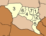
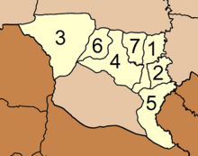
The district is subdivided into 7 subdistricts (tambonTambon
Tambon is a local government unit in Thailand. Below district and province , they form the third administrative subdivision level. As of the 2009 there are 7255 tambon, not including the 169 khwaeng of Bangkok, which are set at the same administrative level, thus every district contains 8-10 tambon...
), which are further subdivided into 74 villages (muban
Muban
Muban is the lowest administrative subdivision of Thailand. Usually translated as village, they are the subdivision of tambon. As of 2008, there are 74944 administrative villages in Thailand. As of the 1990 census, the average village consisted of 144 households or 746 persons.A muban does not...
). There are two subdistrict municipalities (thesaban tambon) - Bang Sawan covers parts of tambon Bang Sawan, and Yan Din Daeng parts of tambon I-pan. There are further 7 Tambon administrative organizations (TAO), responsible for the non-municipal areas.
|
 |
External links
- amphoe.com (Thai)