
Amphoe Ao Luek
Encyclopedia
Ao Luek is a district (amphoe
) in Krabi Province
, Thailand
.
, Khao Phanom
, Mueang Krabi
. To the south west it borders the Phang Nga Bay
, to the west is Thap Put
of Phang Nga Province
.
Than Bok Khorani National Park was established on September 30, 1998 and covers 104 km² of coastal limestone hills and 23 islands off the coast. Within the national park is the skull cave
(Tham Hua Kalok), containing prehistoric paintings.
), which are further subdivided into 51 villages (muban
). There are two townships (thesaban tambon) - Ao Luek Tai covering parts of tambon Ao Luek Tai and Ao Luek Nuea, and Laem Sak covering parts of tambon Laem Sak. Each tambon has a tambon administrative organization (TAO), responsible for the area not belonging to any of the townships.
Amphoe
An amphoe is the second level administrative subdivision of Thailand. Usually translated as district, amphoe make up the provinces, and are analogous to a county seat...
) in Krabi Province
Krabi Province
Krabi is one of the southern provinces of Thailand, at the shore of the Andaman Sea. Neighbouring provinces are Phang Nga, Surat Thani, Nakhon Si Thammarat and Trang. The Phuket province to the west is also neighbouring, but without any land boundary...
, Thailand
Thailand
Thailand , officially the Kingdom of Thailand , formerly known as Siam , is a country located at the centre of the Indochina peninsula and Southeast Asia. It is bordered to the north by Burma and Laos, to the east by Laos and Cambodia, to the south by the Gulf of Thailand and Malaysia, and to the...
.
Geography
Neighboring districts are (from the north clockwise) Plai PhrayaAmphoe Plai Phraya
-Geography:Neighboring districts are Phanom, Phrasaeng, Chai Buri , Khao Phanom and Ao Luek of Krabi Province, and Thap Put of Phang Nga Province....
, Khao Phanom
Amphoe Khao Phanom
-History:The minor district was created on December 1 1967 by adding together the tambon Khao Phanom, Khao Din and 2 villages of Khok Yang of Mueang Krabi district and tambon Sin Pun from Khlong Thom...
, Mueang Krabi
Amphoe Mueang Krabi
Krabi is the capital district of Krabi Province in southern Thailand.-Geography:Neighboring districts are Ao Luek, Khao Phanom and Nuea Khlong. To the south and west borders the Phang Nga Bay....
. To the south west it borders the Phang Nga Bay
Phang Nga Bay
Phang Nga Bay is a 400 km² bay in the Andaman Sea between the island of Phuket and the mainland of the Malay peninsula of southern Thailand. Since 1981, an extensive section of the bay has been protected as the Ao Phang Nga National Park...
, to the west is Thap Put
Amphoe Thap Put
Thap Phut is a district in the province Phang Nga in the south of Thailand.-History:In 1785 Burmese troops attacked Mueang Thalang. The inhabitants escaped from Thalang to the area of modern-day Thap Put. They built shelter that in southern Thai language are called Thap...
of Phang Nga Province
Phang Nga Province
Phang Nga is one of the southern provinces of Thailand, on the shore to the Andaman Sea. Neighboring provinces are Ranong, Surat Thani and Krabi. To the south is the Phuket province, but without land boundary to Phang Nga....
.
Than Bok Khorani National Park was established on September 30, 1998 and covers 104 km² of coastal limestone hills and 23 islands off the coast. Within the national park is the skull cave
Tham Hua Kalok
Tham Hua Kalok is a cave in Ao Luek district near Phangnga Bay in southern Thailand. The cave contains prehistoric paintings in black and red pigment of humans and strange animals. The cave is within the Than Bok Khorani National Park.-References:...
(Tham Hua Kalok), containing prehistoric paintings.
Administration
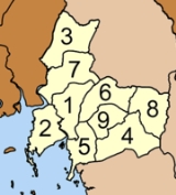
The district is subdivided into 9 sub-districts (tambonTambon
Tambon is a local government unit in Thailand. Below district and province , they form the third administrative subdivision level. As of the 2009 there are 7255 tambon, not including the 169 khwaeng of Bangkok, which are set at the same administrative level, thus every district contains 8-10 tambon...
), which are further subdivided into 51 villages (muban
Muban
Muban is the lowest administrative subdivision of Thailand. Usually translated as village, they are the subdivision of tambon. As of 2008, there are 74944 administrative villages in Thailand. As of the 1990 census, the average village consisted of 144 households or 746 persons.A muban does not...
). There are two townships (thesaban tambon) - Ao Luek Tai covering parts of tambon Ao Luek Tai and Ao Luek Nuea, and Laem Sak covering parts of tambon Laem Sak. Each tambon has a tambon administrative organization (TAO), responsible for the area not belonging to any of the townships.
|
 |