

Khotan River
Encyclopedia
White Jade River
The Yorungqash or White Jade River, also spelt Yorungkax , is a river in the southern Xinjiang region, People's Republic of China.The head waters of the river rise in the Kunlun Mountains, in the Togatax area . The river flows east for some 200 km and then north for another 200 km before passing...
(Yurungkash) and Black Jade (Karakash) Rivers, which flow north from the Kunlun Mountains
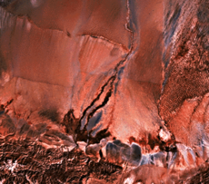
Kunlun Mountains
The Kunlun Mountains are one of the longest mountain chains in Asia, extending more than 3,000 km. In the broadest sense, it forms the northern edge of the Tibetan Plateau south of the Tarim Basin and the Gansu Corridor and continues east south of the Wei River to end at the North China Plain.The...
into the Taklamakan Desert
Taklamakan
The Taklamakan Desert , also known as Taklimakan and Teklimakan, is a desert in Central Asia, in the Xinjiang Uyghur Autonomous Region of the People's Republic of China...
in northern China
China
Chinese civilization may refer to:* China for more general discussion of the country.* Chinese culture* Greater China, the transnational community of ethnic Chinese.* History of China* Sinosphere, the area historically affected by Chinese culture...
. The two rivers unite towards the middle of the desert, some 145 kilometres (90.1 mi) north of the town of Khotan
Khotan
Hotan , or Hetian , also spelled Khotan, is the seat of the Hotan Prefecture in Xinjiang, China. It was previously known in Chinese as 于窴/於窴 and to 19th-century European explorers as Ilchi....
. The river then flows 290 kilometres (180.2 mi) northwards across the desert and empties itself into the Tarim River
Tarim River
The Tarim River is the principal river of the Xinjiang Uygur Autonomous Region in the People's Republic of China...
. Because the river is fed by melting snow from the mountains, it only carries water during the summer and is dry the rest of the year. The Khotan river bed provides the only transportation system across the Tarim Basin
Tarim Basin
The Tarim Basin is a large endorheic basin occupying an area of about . It is located in the Xinjiang Uyghur Autonomous Region in China's far west. Its northern boundary is the Tian Shan mountain range and its southern is the Kunlun Mountains on the northern edge of the Tibetan Plateau. The...
.