
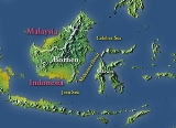
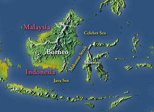
Makassar Strait
Encyclopedia
Strait
A strait or straits is a narrow, typically navigable channel of water that connects two larger, navigable bodies of water. It most commonly refers to a channel of water that lies between two land masses, but it may also refer to a navigable channel through a body of water that is otherwise not...
between the islands of Borneo
Borneo
Borneo is the third largest island in the world and is located north of Java Island, Indonesia, at the geographic centre of Maritime Southeast Asia....
and Sulawesi
Sulawesi
Sulawesi is one of the four larger Sunda Islands of Indonesia and is situated between Borneo and the Maluku Islands. In Indonesia, only Sumatra, Borneo, and Papua are larger in territory, and only Java and Sumatra have larger Indonesian populations.- Etymology :The Portuguese were the first to...
in Indonesia
Indonesia
Indonesia , officially the Republic of Indonesia , is a country in Southeast Asia and Oceania. Indonesia is an archipelago comprising approximately 13,000 islands. It has 33 provinces with over 238 million people, and is the world's fourth most populous country. Indonesia is a republic, with an...
. To the north it joins the Celebes Sea
Celebes Sea
The Celebes Sea of the western Pacific Ocean is bordered on the north by the Sulu Archipelago and Sulu Sea and Mindanao Island of the Philippines, on the east by the Sangihe Islands chain, on the south by Sulawesi, and on the west by Kalimantan in Indonesia...
, while to the south it meets the Java Sea
Java Sea
The Java Sea is a large shallow sea on the Sunda Shelf. It was formed as sea levels rose at the end of the last ice age. The Java Sea lies between the Indonesian islands of Borneo to the north, Java to the south; Sumatra to the west, and Sulawesi to the east...
.
The Mahakam River
Mahakam River
The Mahakam River is in Indonesia. It flows 980 km from the district of Long Apari in the highlands of Borneo, to its mouth at the Makassar Strait....
of Borneo empties into the strait.
Ports along the strait include Balikpapan
Balikpapan
Balikpapan is a seaport city on the eastern coast of the island of Borneo, Indonesia, in the East Kalimantan province, a resource-rich region well known for its timber, mining, and petroleum export products. Two harbors, Semayang and Kariangau , and the Sepinggan International Airport are the main...
in Borneo, and Makassar
Makassar
Makassar, is the provincial capital of South Sulawesi, Indonesia, and the largest city on Sulawesi Island. From 1971 to 1999, the city was named Ujung Pandang, after a precolonial fort in the city, and the two names are often used interchangeably...
and Palu
Palu
Palu is a chartered city on the Indonesian island of Sulawesi, located 1,650 km northeast of Jakarta, at . It is the capital of the province of Central Sulawesi. The city sits on the mouth of Palu River, at the head of a long, narrow bay. Because of its sheltered position between mountain...
in Sulawesi. The city of Samarinda
Samarinda
Samarinda is the capital of the Indonesian province of East Kalimantan on the island of Borneo. The city lies on the banks of the Mahakam River. It is the most populous city in East Kalimantan with a population of 726,223...
is 48 km (30 mi) from the strait, along the Mahakam.
The strait is a common shipping route for ocean going ships too big to fit through the Straits of Malacca.
Extent
The International Hydrographic OrganizationInternational Hydrographic Organization
The International Hydrographic Organization is the inter-governmental organisation representing the hydrographic community. It enjoys observer status at the UN and is the recognised competent authority on hydrographic surveying and nautical charting...
(IHO) defines the Makassar Strait as being one of the waters of the East Indian Archipelago
East Indian Archipelago
The East Indian Archipelago is a marine area designated by the International Hydrographic Organization . It consists of a number of seas and straits in the East Indies ....
. The IHO defines its limits as follows:
The channel between the East coast of BorneoBorneoBorneo is the third largest island in the world and is located north of Java Island, Indonesia, at the geographic centre of Maritime Southeast Asia....
and the West coast of Celebes[ SulawesiSulawesiSulawesi is one of the four larger Sunda Islands of Indonesia and is situated between Borneo and the Maluku Islands. In Indonesia, only Sumatra, Borneo, and Papua are larger in territory, and only Java and Sumatra have larger Indonesian populations.- Etymology :The Portuguese were the first to...] , is bounded:
On the North. By a line joining Tanjong Mangkalihat, Borneo (1°02′N 118°57′E) and Stroomen Kaap (Cape Rivers), Celebes (1°20′N 120°52′E).
On the South. By a line from the Southwestern extreme of Celebes (5°37′S 119°27′E), through the Southern point of Tana Keke, to the Southern extreme of Laoet
Laut IslandLaut is an island in the Kota Baru Regency in the Indonesian province of South Kalimantan. It has an area of 2,062 km2....
(4°06′S 116°06′E) thence up the West coast of that island to Tanjong Kiwi and thence across to Tanjong Petang, Borneo (3°37′S 115°57′E) at the Southern end of Laoet Strait.
See also
- Battle of Makassar StraitBattle of Makassar StraitThe Battle of Makassar Strait, also known as the Action of Madura Strait, the Action North of Lombok Strait and the Battle of the Flores Sea, was a naval battle of the Pacific theater of World War II...
- USS Makassar Strait
- Strait of MalaccaStrait of MalaccaThe Strait of Malacca is a narrow, stretch of water between the Malay Peninsula and the Indonesian island of Sumatra. It is named after the Malacca Sultanate that ruled over the archipelago between 1414 to 1511.-Extent:...
- Sunda StraitSunda StraitThe Sunda Strait is the strait between the Indonesian islands of Java and Sumatra. It connects the Java Sea to the Indian Ocean...
- Lombok StraitLombok StraitThe Lombok Strait is a strait connecting the Java Sea to the Indian Ocean, located between the islands of Bali and Lombok in Indonesia. The Gili Islands are on the Lombok side....
- Wallace LineWallace LineThe Wallace Line separates the ecozones of Asia and Wallacea, a transitional zone between Asia and Australia. West of the line are found organisms related to Asiatic species; to the east, a mixture of species of Asian and Australian origin is present...
- Sadang RiverSadang RiverThe Sadang is a river of Sulawesi, Indonesia. It is one of the major rivers which flow into the Strait of Macassar....