
Stony Plain Road
Encyclopedia
Stony Plain Road is a major arterial road
in west Edmonton
, Alberta
, Canada
. Parkland Highway is an alternative route to the corresponding section of Alberta Highway 16 in Parkland County
.
near the hamlet of Carvel
, where it is known as Parkland Highway given the provincial highway number 16A. Parkland Highway goes through the bedroom communities of Stony Plain, where it is a central thoroughfare, and Spruce Grove
where it is the southern boundary. At Acheson
it intersects with Highway 60. The Parkland Highway then becomes known as Stony Plain Road on the outskirts of Edmonton.
. Both sections cross Edmonton's ring road
, Anthony Henday Drive. After Anthony Henday Northbound, there are a few eastbound lanes, to better serve Place LaRue
, a commercial area with big-box stores, hotels, restaurants, and other commercial activity catering to travellers and commuters. This is especially true near the intersection with 170 Street; however, Stony Plain Road is primarily a westbound road, and the eastbound lanes end at 175 Street. After 170 Street the road again caries both directions of traffic, but 100 Avenue remains a one-way street until 163 Street. East of 170 Street the road passes by the Mayfield Common strip mall, and through some mixed residential-commercial areas (Glenwood
) and a low-income neighbourhood (Britannia Youngstown
). At 142 Street, Stony Plain Road becomes 102 Avenue, and continues through downtown
.
 Stony Plain Road begins again as an outshoot of 102 Avenue into the quiet, upscale residential neighbourhoods of Glenora
and, after passing over Groat Road
, Westmount
. After crossing 121 Street, the road's name changes to 104 Avenue. 104 Avenue passes in front of the old Molson's brewery
.
Prior to 1989, 104 Avenue formed the south boundary of the Old Canadian National rail yard
. After the railway yard's closure, 104 Avenue became a major site of redevlopment. Here the road passes a block south of the boundary between Oliver
and Downtown
and the neighbourhoods of Queen Mary Park
and Central McDougall
, the so-called "North Edge" of downtown. In the area to either side of 116 Street, 104 Avenue is lined to north by the Oliver Square West and East strip mall
s and condo developments, and to the south by the Longstreet Mall and several other smaller strip malls. From 112 Street to 104 Street, 104 Avenue runs along the south side of Grant MacEwan University City Centre Campus. Continuing east, 104 Avenue passes the 104 Street Promenade in Edmonton's warehouse district, the Bacarat Casino, and the Greyhound Bus terminal.
At 101 Street, the road again changes names to 103A Avenue, it then passes on the south side of the CN Tower
, the north side of Edmonton City Hall
, the south side of Edmonton Police
Headquarters, and the north side of Chinatown. Eventually it merges into Jasper Avenue.
and Government House (Alberta)
. Then it sees the start of Jasper Avenue at 125 Street. At 124 Street
it goes from being an arterial to a collector road
, as it enters the neighbourhood of Oliver. 102 Avenue comes to an end at 111 Street.
Arterial road
An arterial road, or arterial thoroughfare, is a high-capacity urban road. The primary function of an arterial road is to deliver traffic from collector roads to freeways, and between urban centres at the highest level of service possible. As such, many arteries are limited-access roads, or feature...
in west Edmonton
Edmonton
Edmonton is the capital of the Canadian province of Alberta and is the province's second-largest city. Edmonton is located on the North Saskatchewan River and is the centre of the Edmonton Capital Region, which is surrounded by the central region of the province.The city and its census...
, Alberta
Alberta
Alberta is a province of Canada. It had an estimated population of 3.7 million in 2010 making it the most populous of Canada's three prairie provinces...
, Canada
Canada
Canada is a North American country consisting of ten provinces and three territories. Located in the northern part of the continent, it extends from the Atlantic Ocean in the east to the Pacific Ocean in the west, and northward into the Arctic Ocean...
. Parkland Highway is an alternative route to the corresponding section of Alberta Highway 16 in Parkland County
Parkland County, Alberta
Parkland County is a municipal district in central Alberta, Canada.It is located west of Edmonton in Census Division No. 11, along the Parkland Highway...
.
Parkland Highway
The road starts west of Stony Plain, AlbertaStony Plain, Alberta
Stony Plain is a large town in rural Alberta, Canada, just west of Edmonton.Stony Plain is a rapidly growing town with strong historical roots. It is located west of Spruce Grove and surrounded by Parkland County. The town is governed by one mayor and six councillors. The region is dominated by...
near the hamlet of Carvel
Carvel, Alberta
Carvel is a hamlet in Alberta, Canada within Parkland County. It is located on Highway 770, approximately west of Edmonton.Carvel's largest building is the St...
, where it is known as Parkland Highway given the provincial highway number 16A. Parkland Highway goes through the bedroom communities of Stony Plain, where it is a central thoroughfare, and Spruce Grove
Spruce Grove, Alberta
Spruce Grove is a city in the vicinity of Edmonton, Alberta. Like nearby Stony Plain it is surrounded by Parkland County.With a population of 24,646, Spruce Grove is the 11th largest city in Alberta. The Horizon Stage Performing Arts Centre is the local theatre, and its TransAlta Tri Leisure Centre...
where it is the southern boundary. At Acheson
Acheson, Alberta
Acheson is a locality and an industrial area in Alberta, Canada within Parkland County.Acheson is located on the Canadian National main line and Highway 60 between Highway 16A and Highway 16...
it intersects with Highway 60. The Parkland Highway then becomes known as Stony Plain Road on the outskirts of Edmonton.
Stony Plain Road
Stony Plain Road enters Edmonton city limits at 231 Street. Soon after entering the city limits, the westbound and eastbound traffic lanes separate into two separate one-way streets. Stony Plain Road at this time refers only to the westbound street (101 Avenue), while eastbound traffic becomes 100 Avenue100 Avenue, Edmonton
100 Avenue is a major arterial road in west Edmonton, Alberta, Canada.The road starts as Stony Plain Road , and as it approaches Anthony Henday Drive it separates into westbound and eastbound one-way streets. The westbound lanes occupy 101 Avenue, however keeps the name Stony Plain Road, while the...
. Both sections cross Edmonton's ring road
Ring road
A ring road, orbital motorway, beltway, circumferential highway, or loop highway is a road that encircles a town or city...
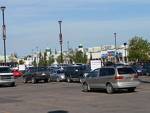
, Anthony Henday Drive. After Anthony Henday Northbound, there are a few eastbound lanes, to better serve Place LaRue
Place LaRue, Edmonton
Place LaRue is a largely commercial neighbourhood located in west Edmonton, Alberta, Canada. According to the 2001 federal census, there were only 75 private dwellings located in the neighbourhood...
, a commercial area with big-box stores, hotels, restaurants, and other commercial activity catering to travellers and commuters. This is especially true near the intersection with 170 Street; however, Stony Plain Road is primarily a westbound road, and the eastbound lanes end at 175 Street. After 170 Street the road again caries both directions of traffic, but 100 Avenue remains a one-way street until 163 Street. East of 170 Street the road passes by the Mayfield Common strip mall, and through some mixed residential-commercial areas (Glenwood
Glenwood, Edmonton
Glenwood is a large neighbourhood in west Edmonton, Alberta, Canada. The neighbourhood has a mixture of residential and commercial development...
) and a low-income neighbourhood (Britannia Youngstown
Britannia Youngstown, Edmonton
Britannia Youngstown is a residential neighbourhood in west Edmonton, Alberta, Canada. Originally part of the Town of Jasper Place, it became part of Edmonton when Jasper Place amalgamated with Edmonton in 1964....
). At 142 Street, Stony Plain Road becomes 102 Avenue, and continues through downtown
Downtown Edmonton
Downtown Edmonton is bounded by 109 Street to the west, 105 Avenue to the north, 97 Street to the east, 97 Avenue, 100 Avenue, and Rossdale Road to the south and Jasper Avenue to the southeast , though many people consider part or all of the surrounding neighborhoods to be part of downtown...
.
103A / 104 Avenue
Glenora, Edmonton
Glenora is a prime residential neighbourhood in the city of Edmonton, Alberta, Canada, overlooking the North Saskatchewan River valley.Glenora is bounded on the east by Groat Road, on the north by 107 Avenue, on the west by 142 Street, and on the south by the river valley and the McKinnon Ravine...
and, after passing over Groat Road
Groat Road
Groat Road is a freeway in Edmonton, Alberta, Canada.At a roundabout west of the University of Alberta, Edmonton's river valley road Saskatchewan Drive branches Groat Road to the north and heads down into the river valley. Here Groat Road crosses the North Saskatchewan River on Groat Bridge. It...
, Westmount
Westmount, Edmonton
Westmount is an established central-west residential neighbourhood in Edmonton, Alberta, Canada. Westmount is wedge shaped with the point in the wedge overlooking the North Saskatchewan River valley, and is geographically close to the downtown core...
. After crossing 121 Street, the road's name changes to 104 Avenue. 104 Avenue passes in front of the old Molson's brewery
Molson Brewery, Edmonton
The Molson Brewery in Edmonton was a commercial brewery that served the province of Alberta, Canada, from 1913 until 2007 when it was closed.It was financed in 1913 by hotelier, politician and businessman William Henry Sheppard, a former mayor of Strathcona. The architect was Bernard Barthel of...
.
Prior to 1989, 104 Avenue formed the south boundary of the Old Canadian National rail yard
Old Canadian National rail yard
The old Canadian National rail yard in Edmonton was once the centre of economic activity in that city. Its redevelopment has fundamentally altered the appearance of the city...
. After the railway yard's closure, 104 Avenue became a major site of redevlopment. Here the road passes a block south of the boundary between Oliver
Oliver, Edmonton
Oliver is one of the oldest residential neighbourhoods in the City of Edmonton, Alberta, Canada. The neighbourhood is named after Frank Oliver, an early Edmonton resident, businessman, and politician...
and Downtown
Downtown Edmonton
Downtown Edmonton is bounded by 109 Street to the west, 105 Avenue to the north, 97 Street to the east, 97 Avenue, 100 Avenue, and Rossdale Road to the south and Jasper Avenue to the southeast , though many people consider part or all of the surrounding neighborhoods to be part of downtown...
and the neighbourhoods of Queen Mary Park
Queen Mary Park, Edmonton
Queen Mary Park is an inner city residential neighbourhood in Edmonton, Alberta, Canada located just outside the downtown core. The neighbourhood occupies land that was once part of the Hudson's Bay Company reserve....
and Central McDougall
Central McDougall, Edmonton
Central McDougall is a largely residential neighbourhood in the City of Edmonton, Alberta, Canada located immediately north of the downtown core....
, the so-called "North Edge" of downtown. In the area to either side of 116 Street, 104 Avenue is lined to north by the Oliver Square West and East strip mall
Strip mall
A strip mall is an open-area shopping center where the stores are arranged in a row, with a sidewalk in front. Strip malls are typically developed as a unit and have large parking lots in front...
s and condo developments, and to the south by the Longstreet Mall and several other smaller strip malls. From 112 Street to 104 Street, 104 Avenue runs along the south side of Grant MacEwan University City Centre Campus. Continuing east, 104 Avenue passes the 104 Street Promenade in Edmonton's warehouse district, the Bacarat Casino, and the Greyhound Bus terminal.
At 101 Street, the road again changes names to 103A Avenue, it then passes on the south side of the CN Tower
CN Tower (Edmonton)
CN Tower is an office tower in Edmonton, Alberta, Canada. It stands at or 26 storeys tall, and was built and formerly owned by the Canadian National Railway Company. At the time of its construction it was the first skyscraper in Edmonton, and the tallest building in Western Canada...
, the north side of Edmonton City Hall
Edmonton City Hall
Edmonton's City Hall was designed by Dub Architects, and completed in 1992. It features two steel and glass pyramids, one 43 meters high , on top of a three-story concrete structure. One pyramid provides natural light for the main atrium, the other for the council chambers...
, the south side of Edmonton Police
Edmonton Police Service
Edmonton Police Service is the municipal police force for the City of Edmonton, Alberta, Canada.-Organization:The current head of the EPS is Roderick Knecht....
Headquarters, and the north side of Chinatown. Eventually it merges into Jasper Avenue.
102 Avenue
102 Avenue is a short arterial road west of downtown Edmonton. The 102 Avenue is first occupied by Stony Plain Road at 149 Street. It then changes name to 102 Avenue at 142 Street. Before flying over Groat Road it passes by the Royal Alberta MuseumRoyal Alberta Museum
The Royal Alberta Museum is located in Edmonton, Alberta and was named the Provincial Museum of Alberta until 24 May 2005 when Queen Elizabeth II visited, bestowing royal patronage. It has a natural history exhibit, a wildlife exhibit, an entomology exhibit, a Native Culture exhibit, as well as...
and Government House (Alberta)
Government House (Alberta)
Government House is the former official residence of the lieutenant governors of Alberta, currently retained for ceremonial events and entertaining.The property for the house was purchased by the Province of Alberta in 1910, as well as the surrounding area...
. Then it sees the start of Jasper Avenue at 125 Street. At 124 Street
124 Street, Edmonton
124 Street is an arterial road in north-central Edmonton, Alberta, Canada. It is one route for commuters from Downtown Edmonton to north Edmonton....
it goes from being an arterial to a collector road
Collector road
A collector road or distributor road is a low to moderate-capacity road which serve to move traffic from local streets to arterial roads. Unlike arterials, collectors are also designed to provide access to residential properties...
, as it enters the neighbourhood of Oliver. 102 Avenue comes to an end at 111 Street.
Neighbourhoods
List of neighbourhoods Stony Plain Road runs through, in order from west to east:- Beach Corner, Parkland CountyParkland County, AlbertaParkland County is a municipal district in central Alberta, Canada.It is located west of Edmonton in Census Division No. 11, along the Parkland Highway...
- Meridian Meadows, Stony Plain
- Meridian Heights, Stony PlainStony Plain, AlbertaStony Plain is a large town in rural Alberta, Canada, just west of Edmonton.Stony Plain is a rapidly growing town with strong historical roots. It is located west of Spruce Grove and surrounded by Parkland County. The town is governed by one mayor and six councillors. The region is dominated by...
- Homesteads, Stony Plain
- Legacy Park, Spruce Grove
- Westgrove, Spruce Grove
- Mobile City Estates, Spruce Grove
- City Centre, Spruce GroveSpruce Grove, AlbertaSpruce Grove is a city in the vicinity of Edmonton, Alberta. Like nearby Stony Plain it is surrounded by Parkland County.With a population of 24,646, Spruce Grove is the 11th largest city in Alberta. The Horizon Stage Performing Arts Centre is the local theatre, and its TransAlta Tri Leisure Centre...
- Broxton Park, Spruce Grove
- Lakewood, Spruce Grove
- AchesonAcheson, AlbertaAcheson is a locality and an industrial area in Alberta, Canada within Parkland County.Acheson is located on the Canadian National main line and Highway 60 between Highway 16A and Highway 16...
, Parkland County - SecordSecord, EdmontonSecord is a neighbourhood in west Edmonton, Alberta, Canada that was established in 2007 through the adoption of the Secord Neighbourhood Structure Plan...
- Stewart GreensStewart Greens, EdmontonStewart Greens is a new neighbourhood in west Edmonton, Alberta, Canada.It is bounded on the east by Anthony Henday Drive and on the north by Stony Plain Road....
- La PerleLa Perle, EdmontonLa Perle is a residential neighbourhood in west Edmonton, Alberta, Canada. The neighbourhood is named for a resident who operated a general store in the area in the early. 20th century....
- Place LaRuePlace LaRue, EdmontonPlace LaRue is a largely commercial neighbourhood located in west Edmonton, Alberta, Canada. According to the 2001 federal census, there were only 75 private dwellings located in the neighbourhood...
- Terra LosaTerra Losa, EdmontonTerra Losa is a mixed residential and commercial neighborhood located in west Edmonton, Alberta, Canada.It is bounded on the east by 170 Street, on the south by 95 Avenue, on the west by 178 Street, and on the north by 100 Avenue and 99A Avenue .-Residential development:Terra Losa is a newer...
- Britannia YoungstownBritannia Youngstown, EdmontonBritannia Youngstown is a residential neighbourhood in west Edmonton, Alberta, Canada. Originally part of the Town of Jasper Place, it became part of Edmonton when Jasper Place amalgamated with Edmonton in 1964....
- GlenwoodGlenwood, EdmontonGlenwood is a large neighbourhood in west Edmonton, Alberta, Canada. The neighbourhood has a mixture of residential and commercial development...
- West Jasper PlaceWest Jasper Place, EdmontonWest Jasper Place is a residential neighbourhood in west Edmonton, Alberta, Canada. Originally part of the Town of Jasper Place, West Jasper Place became a part of Edmonton when Edmonton and Jasper Place amalgamated on August 17, 1964....
- CanoraCanora, EdmontonCanora is a residential neighbourhood in west Edmonton, Alberta, Canada. Canora was originally part of the Town of Jasper Place, and became a part of Edmonton when Jasper Place amalgamated with the city in 1964....
- GrovenorGrovenor, EdmontonGrovenor is a residential neighbourhood in west Edmonton, Alberta, Canada. It was originally called Westgrove and a professional building on 142 Street still uses that name....
- GlenoraGlenora, EdmontonGlenora is a prime residential neighbourhood in the city of Edmonton, Alberta, Canada, overlooking the North Saskatchewan River valley.Glenora is bounded on the east by Groat Road, on the north by 107 Avenue, on the west by 142 Street, and on the south by the river valley and the McKinnon Ravine...
- OliverOliver, EdmontonOliver is one of the oldest residential neighbourhoods in the City of Edmonton, Alberta, Canada. The neighbourhood is named after Frank Oliver, an early Edmonton resident, businessman, and politician...
- DowntownDowntown EdmontonDowntown Edmonton is bounded by 109 Street to the west, 105 Avenue to the north, 97 Street to the east, 97 Avenue, 100 Avenue, and Rossdale Road to the south and Jasper Avenue to the southeast , though many people consider part or all of the surrounding neighborhoods to be part of downtown...
- Boyle StreetBoyle Street, EdmontonBoyle Street is a neighbourhood located in central Edmonton, Alberta, Canada, immediately east of the downtown core...
Interchanges and intersections
This is a list of major intersections, starting at the west end of Highway 16A.As Parkland Highway 16A
| County | km Exit number An exit number is a number assigned to a road junction, usually an exit from a freeway. It is usually marked on the same sign as the destinations of the exit, as well as a sign in the gore.... |
Intersecting road | Notes | Coordinates |
|---|---|---|---|---|
| Parkland County Parkland County, Alberta Parkland County is a municipal district in central Alberta, Canada.It is located west of Edmonton in Census Division No. 11, along the Parkland Highway... |
0 | (Exit 344), Township Road 522 | Y interchange West to Wabamun Lake Wabamun Lake Wabamun Lake is one of the most heavily used lakes in Alberta, Canada. It lies west of Edmonton, Alberta. It is long and narrow, covers and is 11 meters deep at its deepest, with somewhat clear water.... |
53°34′10"N 114°9′34"W |
| 5 | Parkland Drive, Township Road 520 | West to Carvel Carvel, Alberta Carvel is a hamlet in Alberta, Canada within Parkland County. It is located on Highway 770, approximately west of Edmonton.Carvel's largest building is the St... |
53°32′30"N 114°5′26"W | |
| 11 | Hwy 779 Alberta Highway 779 Alberta Provincial Highway No. 779 is a highway in the province of Alberta, Canada. It runs south-north from Highway 627 to Highway 37 west of Calahoo. Stony Plain is the only settlement the highway passes through... , 48 Street, Range Road 10 (Fifth Meridian Dominion Land Survey The Dominion Land Survey is the method used to divide most of Western Canada into one-square-mile sections for agricultural and other purposes. It is based on the layout of the Public Land Survey System used in the United States, but has several differences... , 114° Longitude 114th meridian west The meridian 114° west of Greenwich is a line of longitude that extends from the North Pole across the Arctic Ocean, North America, the Pacific Ocean, the Southern Ocean, and Antarctica to the South Pole.... ) |
Stony Plain Stony Plain, Alberta Stony Plain is a large town in rural Alberta, Canada, just west of Edmonton.Stony Plain is a rapidly growing town with strong historical roots. It is located west of Spruce Grove and surrounded by Parkland County. The town is governed by one mayor and six councillors. The region is dominated by... Partial cloverleaf interchange |
53°32′29"N 114°0′7"W | |
| City of Spruce Grove Spruce Grove, Alberta Spruce Grove is a city in the vicinity of Edmonton, Alberta. Like nearby Stony Plain it is surrounded by Parkland County.With a population of 24,646, Spruce Grove is the 11th largest city in Alberta. The Horizon Stage Performing Arts Centre is the local theatre, and its TransAlta Tri Leisure Centre... |
16 | Campsite Road, Range Road 274 | Traffic lights | 53°32′29"N 113°56′4"W |
| 17 | Calahoo Road/Golden Spike Road, Range Road 273 | Traffic lights | 53°32′28"N 113°54′36"W | |
| 19 | Century Road, Range Road 272 | Traffic lights | 53°32′29"N 113°53′7"W | |
| Parkland County Parkland County, Alberta Parkland County is a municipal district in central Alberta, Canada.It is located west of Edmonton in Census Division No. 11, along the Parkland Highway... |
27 | , Range Road 263 | Acheson Acheson, Alberta Acheson is a locality and an industrial area in Alberta, Canada within Parkland County.Acheson is located on the Canadian National main line and Highway 60 between Highway 16A and Highway 16... Partial cloverleaf interchange |
53°32′29"N 113°45′46"W |
| City of Edmonton Edmonton Edmonton is the capital of the Canadian province of Alberta and is the province's second-largest city. Edmonton is located on the North Saskatchewan River and is the centre of the Edmonton Capital Region, which is surrounded by the central region of the province.The city and its census... |
31 | 231 Street, Range Road 261 | Edmonton City Limits | 53°32′29"N 113°42′49"W |
| 35 | Grade separated, no access | 53°32′28"N 113°39′32"W |
As Stony Plain Road (101 Avenue)
| Direction | Intersecting road | Current intersection type | Coordinates |
|---|---|---|---|
| West-East | 231 Street (Edmonton City Limits) | At-grade | 53°32′29"N 113°42′49"W |
| Winterburn Road (215 Street) Winterburn Road Winterburn Road is a major arterial road in west Edmonton, Alberta, Canada. It is a rural grid road that earned the name 215 Street when Edmonton expanded this far to the west.... |
Partial cloverleaf interchange | 53°32′28"N 113°41′19"W | |
| 100 Avenue 100 Avenue, Edmonton 100 Avenue is a major arterial road in west Edmonton, Alberta, Canada.The road starts as Stony Plain Road , and as it approaches Anthony Henday Drive it separates into westbound and eastbound one-way streets. The westbound lanes occupy 101 Avenue, however keeps the name Stony Plain Road, while the... |
(West end of diamond) | 53°32′28"N 113°40′12"W | |
| Anthony Henday | Grade separated, no access | 53°32′28"N 113°39′32"W | |
| 184 Street | At-grade (traffic lights) | 53°32′28"N 113°38′23"W | |
| 178 Street | At-grade (traffic lights) | 53°32′29"N 113°37′39"W | |
| 170 Street 170 Street, Edmonton 170 Street is a major arterial road in west Edmonton, Alberta, Canada. It serves residential, commercial and industrial areas.Gervais / Hebert Road is a major arterial road in south St. Albert, Alberta, Canada. It serves residential and commercial areas.The portion of 170 Street between Whitemud... (to Mayfield Road Mayfield Road, Edmonton Mayfield Road is an arterial road in west Edmonton, Alberta, Canada.It begins as 170 Street north of Stony Plain Road, and travels north-east for about ten blocks before it turns east and continues as 111 Avenue. Mayfield Road bounds the residential neighbourhoods of Britannia Youngstown and... ) |
Diamond interchange Diamond interchange A diamond interchange is a common type of road junction, used where a freeway crosses a minor road. The freeway itself is grade-separated from the minor road, one crossing the other over a bridge... at-grade |
53°32′29"N 113°36′57"W | |
| 163 Street | At-grade (traffic lights) | 53°32′29"N 113°36′10"W | |
| 156 Street 156 Street, Edmonton 156 Street is a major arterial road in west Edmonton, and east St. Albert, Alberta, Canada. In Edmonton, 156 Street runs through the old town of Jasper Place, and Edmonton's west industrial district. St. Albert names their roads, rather than numbering them, even if a street runs straight from... |
At-grade (traffic lights) | 53°32′29"N 113°35′25"W | |
| 149 Street | At-grade (traffic lights) | 53°32′30"N 113°34′41"W |
As only Stony Plain Road
| Direction | Intersecting road | Current intersection type | Coordinates |
|---|---|---|---|
| West-East | 142 Street | At-grade (traffic lights) | 53°32′34"N 113°33′57"W |
| Southwest-Northeast | 102 Avenue | At-grade Y interchange | 53°32′35"N 113°33′44"W |
| 136 Street | At-grade | 53°32′41"N 113°33′23"W | |
| Groat Road Groat Road Groat Road is a freeway in Edmonton, Alberta, Canada.At a roundabout west of the University of Alberta, Edmonton's river valley road Saskatchewan Drive branches Groat Road to the north and heads down into the river valley. Here Groat Road crosses the North Saskatchewan River on Groat Bridge. It... |
Flyover Overpass An overpass is a bridge, road, railway or similar structure that crosses over another road or railway... |
53°32′52"N 113°32′45"W | |
| West-East | 124 Street 124 Street, Edmonton 124 Street is an arterial road in north-central Edmonton, Alberta, Canada. It is one route for commuters from Downtown Edmonton to north Edmonton.... |
At-grade (traffic lights) | 53°32′49"N 113°32′9"W |
As 102 Avenue
| Direction | Intersecting road | Current intersection type | Coordinates |
|---|---|---|---|
| West-East | 142 Street | At-grade (traffic lights) | 53°32′34"N 113°33′57"W |
| Stony Plain Road | At-grade Y interchange | 53°32′35"N 113°33′44"W | |
| Groat Road Groat Road Groat Road is a freeway in Edmonton, Alberta, Canada.At a roundabout west of the University of Alberta, Edmonton's river valley road Saskatchewan Drive branches Groat Road to the north and heads down into the river valley. Here Groat Road crosses the North Saskatchewan River on Groat Bridge. It... |
Flyover | 53°32′35"N 113°32′25"W | |
| 125 Street / Jasper Avenue | At-grade | 53°32′35"N 113°32′16"W | |
| 124 Street 124 Street, Edmonton 124 Street is an arterial road in north-central Edmonton, Alberta, Canada. It is one route for commuters from Downtown Edmonton to north Edmonton.... |
At-grade (traffic lights) | 53°32′35"N 113°32′9"W | |
| 116 Street | At-grade | 53°32′35"N 113°31′17"W | |
| 111 Street | At-grade | 53°32′35"N 113°30′44"W |
As 103A / 104 Avenues
| Direction | Intersecting road | Current intersection type | Coordinates |
|---|---|---|---|
| West-East | 121 Street | At-grade (traffic lights) | 53°32′46"N 113°31′51"W |
| 116 Street | At-grade (traffic lights) | 53°32′46"N 113°31′17"W | |
| 109 Street 109 Street, Edmonton 109 Street is an arterial road in central Edmonton, Alberta, Canada. It takes travelers out of Downtown to the south, Old Strathcona, and the north, Kingsway area. It passes several Edmonton landmarks including the Garneau Theatre, Alberta Legislature Building, Grant MacEwan University, RCMP "K"... |
At-grade (traffic lights) | 53°32′46"N 113°30′30"W | |
| 105 Street 105 Street, Edmonton 105 Street is an arterial road in Downtown Edmonton, Alberta, Canada. It starts across the North Saskatchewan River from Downtown, as one way streets Walterdale Hill and Queen Elizabeth Park Road, which join and continue north on Walterdale Bridge... |
At-grade (traffic lights) | 53°32′46"N 113°30′4"W | |
| 101 Street | At-grade (traffic lights) | 53°32′46"N 113°29′37"W | |
| 100 Street | At-grade (traffic lights) | 53°32′46"N 113°29′28"W | |
| 97 Street 97 Street, Edmonton 97 Street is a major arterial road in north Edmonton, Alberta, Canada. It is used to take travelers in and out of Downtown Edmonton to the city's northern suburban neighbourhoods and communities such as CFB Edmonton. The neighbourhood along the west side, between 137 and 153 Avenues, Griesbach,... |
At-grade (traffic lights) | 53°32′48"N 113°29′14"W | |
| 92 Street / Jasper Avenue | At-grade | 53°32′56"N 113°28′31"W |