

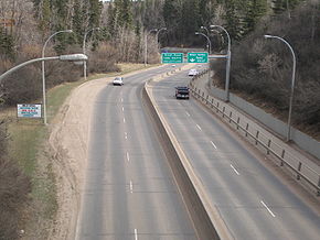
Groat Road
Encyclopedia
Edmonton
Edmonton is the capital of the Canadian province of Alberta and is the province's second-largest city. Edmonton is located on the North Saskatchewan River and is the centre of the Edmonton Capital Region, which is surrounded by the central region of the province.The city and its census...
, Alberta
Alberta
Alberta is a province of Canada. It had an estimated population of 3.7 million in 2010 making it the most populous of Canada's three prairie provinces...
, Canada
Canada
Canada is a North American country consisting of ten provinces and three territories. Located in the northern part of the continent, it extends from the Atlantic Ocean in the east to the Pacific Ocean in the west, and northward into the Arctic Ocean...
.
At a roundabout
Roundabout
A roundabout is the name for a road junction in which traffic moves in one direction around a central island. The word dates from the early 20th century. Roundabouts are common in many countries around the world...
west of the University of Alberta
University of Alberta
The University of Alberta is a public research university located in Edmonton, Alberta, Canada. Founded in 1908 by Alexander Cameron Rutherford, the first premier of Alberta and Henry Marshall Tory, its first president, it is widely recognized as one of the best universities in Canada...
, Edmonton's river valley road Saskatchewan Drive branches Groat Road to the north and heads down into the river valley
North Saskatchewan River valley parks system
The North Saskatchewan River valley parks system is a continuous collection of urban parks in the North Saskatchewan River valley of Edmonton, Alberta....
. Here Groat Road crosses the North Saskatchewan River
North Saskatchewan River
The North Saskatchewan River is a glacier-fed river that flows east from the Canadian Rockies to central Saskatchewan. It is one of two major rivers that join to make up the Saskatchewan River....
on Groat Bridge
Groat Bridge
Groat Bridge is a bridge that spans the North Saskatchewan River in Edmonton, Alberta, Canada. It is a part of Groat Road.-External links:...
. It then winds through a gorge before reaching the flat plains at the top of the valley. The route ends, and becomes St. Albert Trail, at 118 Avenue (at a traffic circle
Traffic circle
A traffic circle or rotary is a type of circular intersection in which traffic must travel in one direction around a central island. In some countries, traffic entering the circle has the right-of-way and drivers in the circle must yield. In many other countries, traffic entering the circle must...
with traffic lights).
Because of their short lengths, Wayne Gretzky Drive
Wayne Gretzky Drive
Wayne Gretzky Drive is a freeway in Edmonton, Alberta, Canada. Originally Capilano Drive, it was officially renamed October 1, 1999 after NHL hockey player Wayne Gretzky, as a tribute to his years with the Edmonton Oilers...
and Groat Road will be the only freeways in Edmonton not to have a highway designation, until the completion of Terwillegar Drive
Terwillegar Drive
Terwillegar Drive is a developing freeway in south-west Edmonton, Alberta, Canada. It is currently still under construction, with the majority of its intersection at-grade, it retains its arterial road status...
.
Neighbourhoods
List of neighbourhoods Groat Road runs through, in order from south to north.- Windsor ParkWindsor Park, EdmontonWindsor Park is a south central neighbourhood in the City of Edmonton, Alberta, Canada. It is located immediately to the west of the University of Alberta north campus and overlooking the North Saskatchewan River valley to the north, west, and south west...
- GlenoraGlenora, EdmontonGlenora is a prime residential neighbourhood in the city of Edmonton, Alberta, Canada, overlooking the North Saskatchewan River valley.Glenora is bounded on the east by Groat Road, on the north by 107 Avenue, on the west by 142 Street, and on the south by the river valley and the McKinnon Ravine...
- WestmountWestmount, EdmontonWestmount is an established central-west residential neighbourhood in Edmonton, Alberta, Canada. Westmount is wedge shaped with the point in the wedge overlooking the North Saskatchewan River valley, and is geographically close to the downtown core...
- North GlenoraNorth Glenora, EdmontonNorth Glenora is a residential neighbourhood in west Edmonton, Alberta, Canada.Residential development in North Glenora began before 1946 when one in twenty of the residences were built according to the 2001 federal census. The majority of the residential construction occurred during the fifteen...
- InglewoodInglewood, EdmontonInglewood is a residential neighbourhood in north west Edmonton, Alberta, Canada.Between 1946 and 1996, Edmonton's Charles Camsell Hospital was located in the neighbourhood...
- WoodcroftWoodcroft, EdmontonWoodcroft is a neighbourhood located in north west Edmonton, Alberta, Canada. Coronation Park and the Telus World of Science are located in the neighbourhood. The neighbourhood is surrounded by a mixture of residential neighborhoods and light industrial subdivisions...
Interchanges and intersections
Groat Road currently has six interchanges (bold), giving it freeway status for the 4.1 kilometres (2.5 mi) from 87 Avenue to 109 Avenue.| Direction | Intersecting road | Current intersection type | Coordinates |
|---|---|---|---|
| South-North | 87 Avenue / Saskatchewan Drive Saskatchewan Drive Saskatchewan Drive / Scona Road is a river valley road on the south side of the North Saskatchewan River in Edmonton, Alberta, Canada. It was formed on the banks of the river when the area was known as the City of Strathcona... |
Roundabout Roundabout A roundabout is the name for a road junction in which traffic moves in one direction around a central island. The word dates from the early 20th century. Roundabouts are common in many countries around the world... |
53°31′22"N 113°32′26"W |
| Emily Murphy Park Road (to William Hawrelak Park William Hawrelak Park William Hawrelak Park is a park in Edmonton, Alberta. It is named after former mayor William Hawrelak, and was formerly known as Mayfair Park.The park is situated in Edmonton's river valley, next to the North Saskatchewan River... and Saskatchewan Drive) |
Diamond T interchange Diamond interchange A diamond interchange is a common type of road junction, used where a freeway crosses a minor road. The freeway itself is grade-separated from the minor road, one crossing the other over a bridge... |
53°31′56"N 113°32′17"W | |
| River Valley Road | Partial cloverleaf interchange | 53°32′18"N 113°32′16"W | |
| Victoria Park Road (100 Avenue) 100 Avenue, Edmonton 100 Avenue is a major arterial road in west Edmonton, Alberta, Canada.The road starts as Stony Plain Road , and as it approaches Anthony Henday Drive it separates into westbound and eastbound one-way streets. The westbound lanes occupy 101 Avenue, however keeps the name Stony Plain Road, while the... |
Directional T interchange | 53°32′24"N 113°32′17"W | |
| 102 Avenue | Overpass Overpass An overpass is a bridge, road, railway or similar structure that crosses over another road or railway... |
53°32′35"N 113°32′25"W | |
| Stony Plain Road Stony Plain Road Stony Plain Road is a major arterial road in west Edmonton, Alberta, Canada. Parkland Highway is an alternative route to the corresponding section of Alberta Highway 16 in Parkland County.-Parkland Highway:... |
Overpass | 53°32′52"N 113°32′45"W | |
| 107 Avenue 107 Avenue, Edmonton 107 Avenue is a major arterial road in west-central Edmonton, Alberta, Canada. It serves Edmonton's west side industrial distract, the old town of Jasper Place, the multicultural area north of Downtown Edmonton, Commonwealth Stadium, and adjacent park & ride transit centre... |
Diamond interchange Diamond interchange A diamond interchange is a common type of road junction, used where a freeway crosses a minor road. The freeway itself is grade-separated from the minor road, one crossing the other over a bridge... |
53°33′4"N 113°32′59"W | |
| 111 Avenue | At-grade (traffic lights) | 53°33′32"N 113°33′5"W | |
| 114 Avenue | At-grade (traffic lights) | 53°33′48"N 113°33′5"W | |
| 118 Avenue 118 Avenue, Edmonton 118 Avenue is the designated name of two major arterial roads in central Edmonton, Alberta, Canada, separated by the Edmonton City Centre Airport. The west side services both an industrial area, and a residential area, while the east 118 Avenue, originally Alberta Avenue, is one of the oldest... |
Traffic light controlled traffic circle Traffic circle A traffic circle or rotary is a type of circular intersection in which traffic must travel in one direction around a central island. In some countries, traffic entering the circle has the right-of-way and drivers in the circle must yield. In many other countries, traffic entering the circle must... |
53°34′13"N 113°32′58"W |