
124 Street, Edmonton
Encyclopedia
Arterial road
An arterial road, or arterial thoroughfare, is a high-capacity urban road. The primary function of an arterial road is to deliver traffic from collector roads to freeways, and between urban centres at the highest level of service possible. As such, many arteries are limited-access roads, or feature...
in north-central Edmonton
Edmonton
Edmonton is the capital of the Canadian province of Alberta and is the province's second-largest city. Edmonton is located on the North Saskatchewan River and is the centre of the Edmonton Capital Region, which is surrounded by the central region of the province.The city and its census...
, Alberta
Alberta
Alberta is a province of Canada. It had an estimated population of 3.7 million in 2010 making it the most populous of Canada's three prairie provinces...
, Canada
Canada
Canada is a North American country consisting of ten provinces and three territories. Located in the northern part of the continent, it extends from the Atlantic Ocean in the east to the Pacific Ocean in the west, and northward into the Arctic Ocean...
. It is one route for commuters from Downtown Edmonton
Downtown Edmonton
Downtown Edmonton is bounded by 109 Street to the west, 105 Avenue to the north, 97 Street to the east, 97 Avenue, 100 Avenue, and Rossdale Road to the south and Jasper Avenue to the southeast , though many people consider part or all of the surrounding neighborhoods to be part of downtown...
to north Edmonton.
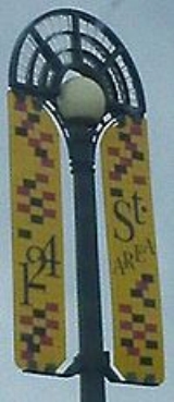
It is home to a variety of shops between Jasper Avenue and 107 Avenue, most notably the galleries of the Gallery Walk.
Neighbourhoods
List of neighbourhoods 124 Street runs through, in order from south to north.- OliverOliver, EdmontonOliver is one of the oldest residential neighbourhoods in the City of Edmonton, Alberta, Canada. The neighbourhood is named after Frank Oliver, an early Edmonton resident, businessman, and politician...
- WestmountWestmount, EdmontonWestmount is an established central-west residential neighbourhood in Edmonton, Alberta, Canada. Westmount is wedge shaped with the point in the wedge overlooking the North Saskatchewan River valley, and is geographically close to the downtown core...
- InglewoodInglewood, EdmontonInglewood is a residential neighbourhood in north west Edmonton, Alberta, Canada.Between 1946 and 1996, Edmonton's Charles Camsell Hospital was located in the neighbourhood...
- Prince CharlesPrince Charles, EdmontonPrince Charles is a residential neighbourhood in north west Edmonton, Alberta. The area was named in honour of the Prince of Wales.The neighbourhood is bounded on the north by the Yellowhead Trail, on the west by 127 Street, on the east by 121 Street, and on the south by 118 Avenue...
Interchanges and intersections
This is a list of major intersections, starting at the south end of 124 Street.| Direction | Intersecting road | Current intersection type | Coordinates |
|---|---|---|---|
| South-North | Jasper (101) Avenue | At-grade | 53°32′29"N 113°32′9"W |
| 102 Avenue | At-grade (traffic lights) | 53°32′35"N 113°32′9"W | |
| Stony Plain Road | At-grade (traffic lights) | 53°32′49"N 113°32′9"W | |
| 107 Avenue 107 Avenue, Edmonton 107 Avenue is a major arterial road in west-central Edmonton, Alberta, Canada. It serves Edmonton's west side industrial distract, the old town of Jasper Place, the multicultural area north of Downtown Edmonton, Commonwealth Stadium, and adjacent park & ride transit centre... |
At-grade (traffic lights) | 53°33′3"N 113°32′9"W | |
| 111 Avenue | At-grade (traffic lights) | 53°33′32"N 113°32′9"W | |
| 114 Avenue | At-grade | 53°33′49"N 113°32′9"W | |
| 118 Avenue 118 Avenue, Edmonton 118 Avenue is the designated name of two major arterial roads in central Edmonton, Alberta, Canada, separated by the Edmonton City Centre Airport. The west side services both an industrial area, and a residential area, while the east 118 Avenue, originally Alberta Avenue, is one of the oldest... (to Kingsway Avenue Kingsway, Edmonton Kingsway, sometimes called Kingsway Avenue, is an arterial road in central Edmonton, Alberta, Canada, that runs on a northwest to southeast path, cutting through the city's normal grid pattern... ) |
At-grade (traffic lights) | 53°34′13"N 113°32′9"W | |
| Yellowhead Trail | At-grade (traffic lights) | 53°34′50"N 113°32′9"W | |
| Yellowhead Corridor alley | At-grade | 53°35′0"N 113°32′9"W |