

105 Street, Edmonton
Encyclopedia
105 Street is an arterial road
in Downtown
Edmonton
, Alberta
, Canada
. It starts across the North Saskatchewan River
from Downtown, as one way streets Walterdale Hill and Queen Elizabeth Park Road, which join and continue north on Walterdale Bridge
. At 100 Avenue, 105 Street becomes a two way street, and continues through Downtown past Grant MacEwan University.
Arterial road
An arterial road, or arterial thoroughfare, is a high-capacity urban road. The primary function of an arterial road is to deliver traffic from collector roads to freeways, and between urban centres at the highest level of service possible. As such, many arteries are limited-access roads, or feature...
in Downtown
Downtown Edmonton
Downtown Edmonton is bounded by 109 Street to the west, 105 Avenue to the north, 97 Street to the east, 97 Avenue, 100 Avenue, and Rossdale Road to the south and Jasper Avenue to the southeast , though many people consider part or all of the surrounding neighborhoods to be part of downtown...
Edmonton
Edmonton
Edmonton is the capital of the Canadian province of Alberta and is the province's second-largest city. Edmonton is located on the North Saskatchewan River and is the centre of the Edmonton Capital Region, which is surrounded by the central region of the province.The city and its census...
, Alberta
Alberta
Alberta is a province of Canada. It had an estimated population of 3.7 million in 2010 making it the most populous of Canada's three prairie provinces...
, Canada
Canada
Canada is a North American country consisting of ten provinces and three territories. Located in the northern part of the continent, it extends from the Atlantic Ocean in the east to the Pacific Ocean in the west, and northward into the Arctic Ocean...
. It starts across the North Saskatchewan River
North Saskatchewan River
The North Saskatchewan River is a glacier-fed river that flows east from the Canadian Rockies to central Saskatchewan. It is one of two major rivers that join to make up the Saskatchewan River....
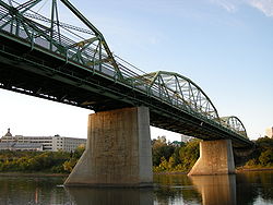
from Downtown, as one way streets Walterdale Hill and Queen Elizabeth Park Road, which join and continue north on Walterdale Bridge
Walterdale Bridge
The Walterdale Bridge is a bridge that spans the North Saskatchewan River in Edmonton, Alberta, Canada. It was built by the Dominion Bridge Company, and was named after John Walter, an early settler who ran a ferry at this approximate location.The bridge is currently slated for replacement, with...
. At 100 Avenue, 105 Street becomes a two way street, and continues through Downtown past Grant MacEwan University.
Interchanges and intersections
This is a list of major intersections, starting at the south end of 105 Street.As Queen Elizabeth Park Road
| Direction | Intersecting road | Current intersection type | Coordinates |
|---|---|---|---|
| East-West | Saskatchewan Drive Saskatchewan Drive Saskatchewan Drive / Scona Road is a river valley road on the south side of the North Saskatchewan River in Edmonton, Alberta, Canada. It was formed on the banks of the river when the area was known as the City of Strathcona... |
3-way junction 3-way junction A 3-way junction is a type of road junction with three arms. A Y junction generally has 3 arms of equal size... |
53°31′27"N 113°29′37"W |
| Southeast-Northwest | (driveways) | At-grade | 53°31′27"N 113°29′53"W |
| East-West | Queen Elizabeth Park access | At-grade | 53°31′36"N 113°30′10"W |
| Walterdale Hill / 105 Street | At-grade (traffic lights) | 53°31′36"N 113°30′12"W | |
| 107 Street | At-grade | 53°31′35"N 113°30′15"W |
As Walterdale Hill
| Direction | Intersecting road | Current intersection type | Coordinates |
|---|---|---|---|
| West-East | 109 Street 109 Street, Edmonton 109 Street is an arterial road in central Edmonton, Alberta, Canada. It takes travelers out of Downtown to the south, Old Strathcona, and the north, Kingsway area. It passes several Edmonton landmarks including the Garneau Theatre, Alberta Legislature Building, Grant MacEwan University, RCMP "K"... / Saskatchewan Drive Saskatchewan Drive Saskatchewan Drive / Scona Road is a river valley road on the south side of the North Saskatchewan River in Edmonton, Alberta, Canada. It was formed on the banks of the river when the area was known as the City of Strathcona... |
At-grade (traffic lights) | 53°31′26"N 113°30′43"W |
| Southwest-Northeast | Old Fort Hill Road (106A Street) | At-grade | 53°31′28"N 113°30′20"W |
| South-North | 91 Avenue / Queen Elizabeth Park Road | At-grade (traffic lights) | 53°31′36"N 113°30′12"W |
| 105 Street | (Walterdale Bridge Walterdale Bridge The Walterdale Bridge is a bridge that spans the North Saskatchewan River in Edmonton, Alberta, Canada. It was built by the Dominion Bridge Company, and was named after John Walter, an early settler who ran a ferry at this approximate location.The bridge is currently slated for replacement, with... ) |
53°31′43"N 113°30′8"W |
As 105 Street
| Direction | Intersecting road | Current intersection type | Coordinates |
|---|---|---|---|
| South-North | River Valley Road / Rossdale Road | At-grade (traffic lights) | 53°31′50"N 113°30′4"W |
| 97 Avenue | At-grade (traffic lights) | 53°32′2"N 113°30′4"W | |
| 100 Avenue | At-grade (traffic lights) | 53°32′20"N 113°30′4"W | |
| Jasper (101) Avenue | At-grade (traffic lights) | 53°32′20"N 113°30′4"W | |
| 104 Avenue | At-grade (traffic lights) | 53°32′46"N 113°30′4"W | |
| 105 Avenue | At-grade (traffic lights) | 53°32′52"N 113°30′4"W | |
| 107 Avenue (of Nations) 107 Avenue, Edmonton 107 Avenue is a major arterial road in west-central Edmonton, Alberta, Canada. It serves Edmonton's west side industrial distract, the old town of Jasper Place, the multicultural area north of Downtown Edmonton, Commonwealth Stadium, and adjacent park & ride transit centre... |
At-grade (traffic lights) | 53°33′5"N 113°30′4"W | |
| 108 Avenue | At-grade | 53°33′11"N 113°30′4"W |