

Starbotton
Encyclopedia
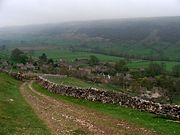
Starbotton is a hamlet and civil parish
in the Craven
district of North Yorkshire
, England
. It is situated in the Yorkshire Dales
National Park, by the River Wharfe
in Wharfedale
. The resident population is only around 75 with many of the village houses being used as holiday accommodation. There are only two remaining working farms - one at either end of the village, the rest having being converted in one way or another. It is on the opposite bank of the River Wharfe to the Dales Way
half way between Kettlewell and Buckden.
) or "Stauerboten" (12th century - Old English "stæfer" replacing the Norse "stafn" in the first form and meaning "the place where stakes are got"). People have lived in this part of the dale since at least the Iron Age
. The area is criss-crossed with pack horse trails from the time when the great monasteries like Fountains Abbey
, Jervaulx and Rievaulx
traded wool and other goods across this part of the Pennines
.
, up the river to Buckden
, over the top to Arncliffe
and over to Coverdale.
Cam Road is a green lane
and has been closed to motor vehicles by the Yorkshire Dales National Park Authority (under the authority of the Natural Environment and Rural Communities Act, 2006) as part of an experiment to reverse damage caused by off-roaders
. The main damage was caused by trail bikes on the steep section and sharp bends just before it enters the village – resulting in the bed of the track becoming almost impassable to pedestrians. Once the surface had been broken, subsequent rains washed the remaining soils away leaving nothing but stone. Even attempts to fill the holes with quarry waste were undone by the traction from motorbikes which sprayed the loose chippings down the hillside.
Other interesting features include the Smelt Flue leading up from the back of the village to the Smelt Chimney above Cam Gill. This is a remnant of the Smeltmill
. It is still possible to crawl through parts of the flue as it climbs the hillside. This was the principal job for children at the mill - to collect the white lead oxide from the sides of the flue. Hence the number of very young people buried in the churchyard at Kettlewell
in the 18th and 19th centuries.
There was a small quarry next to the bridge over Cam Gill Beck leading up to Cam Road (accessed from the lane beside the Fox and Hounds). Many of the buildings in the village were constructed from its stone. This was also refurbished as part of the Millennium Project for the village and the quarry face was replanted to stabilise the hillside. There is also a small pound on the lane at the back of the pub - originally for housing stray animals.
The imposing house with a pointed arch window, looking down the road (next to the pub), was built for the manager of the Smelt Mill. In addition, the barn with an external staircase (restored in 2009), on the bend in the road opposite the Fox and Hounds, once housed a drovers' bar on the upper floor. Beasts could be accommodated at ground level. A little further up the road travelling towards Buckden
the last house on the right hand side is below road level. This was the original pub in the village and its position shows how much the road was raised when the ford across the Cam Gill Beck was converted to a bridge. For many years there was a vast pile of rubble (now removed back to the remaining walls) standing to the north of the former pub. This was once a large barn that, to quote one of the oldest residents (when in his 90's), "collapsed when my wife looked at it - she was a stern woman!". There have been plans for its reinstatement for many years.
On the opposite side of the road, just before the bridge, is what appears to be a small gatehouse beside the entrance gateway to a Victorian dwelling. The roof to this was broken by a loose tank gun, which swung out of control, on a convoy moving through the Dale prior to D-Day
. The owner at the time was too patriotic to claim the costs of the repair and it was not refurbished until the early 2000s. The Victorian house itself is an extension of a much older Dales Long Barn
. The older part appears now as the small cottage attached to the Victorian villa at the end furthest from the road. The neighbouring Cleveliot House (subsequently extended) was built in the 1970s in the style of a typical Dales house of the late 18th century on the site of a former barn dating from 1685.
The major disaster that struck the village occurred in June 1686 when a tremendous rainstorm caused a flash flood, resulted in much of the village being swept away. This occurred only shortly after the rebuilding of the village had started - the earliest dated building being from 1621. Those not damaged beyond repair were restored and new ones built in the late 17th century.
There was an old hall near the gill, converted into three cottages. It went into ruin in the 19th century; one room was used for salving sheep (a procedure that pre-dated sheep-dip). Dated stones from other houses have been built into it but the true reference is inscribed WS 1663 TS. Lady Anne Clifford
spent the night of 26th July 1667 here on one of her journeys up the dale to her Westmorland estates. She wrote in her diary I went into John Symondson's house at Starbotton in Craven, where I lay one night, and then on to Pendragon
.
There is a drinking water tap (discreetly placed) in a lane off to the right of the main road through the village before reaching the pub (when approaching from Kettlewell) close to the site of what was once the village school (now a private house). There are no other public facilities apart from phone booth and post box - both close to the former Village Institute that originally housed the post office, which closed in 1971.
Civil parish
In England, a civil parish is a territorial designation and, where they are found, the lowest tier of local government below districts and counties...
in the Craven
Craven
Craven is a local government district in North Yorkshire, England that came into being in 1974, centred on the market town of Skipton. In the changes to British local government of that year this district was formed as the merger of Skipton urban district, Settle Rural District and most of Skipton...
district of North Yorkshire
North Yorkshire
North Yorkshire is a non-metropolitan or shire county located in the Yorkshire and the Humber region of England, and a ceremonial county primarily in that region but partly in North East England. Created in 1974 by the Local Government Act 1972 it covers an area of , making it the largest...
, England
England
England is a country that is part of the United Kingdom. It shares land borders with Scotland to the north and Wales to the west; the Irish Sea is to the north west, the Celtic Sea to the south west, with the North Sea to the east and the English Channel to the south separating it from continental...
. It is situated in the Yorkshire Dales
Yorkshire Dales
The Yorkshire Dales is the name given to an upland area in Northern England.The area lies within the historic county boundaries of Yorkshire, though it spans the ceremonial counties of North Yorkshire, West Yorkshire and Cumbria...
National Park, by the River Wharfe
River Wharfe
The River Wharfe is a river in Yorkshire, England. For much of its length it is the county boundary between West Yorkshire and North Yorkshire. The name Wharfe is Celtic and means "twisting, winding".The valley of the River Wharfe is known as Wharfedale...
in Wharfedale
Wharfedale
Wharfedale is one of the Yorkshire Dales in England. It is the valley of the River Wharfe. Towns and villages in Wharfedale include Buckden, Kettlewell, Conistone, Grassington, Hebden, Ilkley, Burley-in-Wharfedale, Otley, Pool-in-Wharfedale, Arthington, Collingham, and Wetherby...
. The resident population is only around 75 with many of the village houses being used as holiday accommodation. There are only two remaining working farms - one at either end of the village, the rest having being converted in one way or another. It is on the opposite bank of the River Wharfe to the Dales Way
Dales Way
The Dales Way is an 84-mile Long Distance Footpath in Northern England, from Ilkley, West Yorkshire to Bowness-on-Windermere, Cumbria....
half way between Kettlewell and Buckden.
Etymology
The derivation of the name is the subject of much debate but has nothing to do with "stars" or "bottom". Instead it is thought to be derived from "Stamphotne" (1086 Domesday BookDomesday Book
Domesday Book , now held at The National Archives, Kew, Richmond upon Thames in South West London, is the record of the great survey of much of England and parts of Wales completed in 1086...
) or "Stauerboten" (12th century - Old English "stæfer" replacing the Norse "stafn" in the first form and meaning "the place where stakes are got"). People have lived in this part of the dale since at least the Iron Age
Iron Age
The Iron Age is the archaeological period generally occurring after the Bronze Age, marked by the prevalent use of iron. The early period of the age is characterized by the widespread use of iron or steel. The adoption of such material coincided with other changes in society, including differing...
. The area is criss-crossed with pack horse trails from the time when the great monasteries like Fountains Abbey
Fountains Abbey
Fountains Abbey is near to Aldfield, approximately two miles southwest of Ripon in North Yorkshire, England. It is a ruined Cistercian monastery, founded in 1132. Fountains Abbey is one of the largest and best preserved Cistercian houses in England. It is a Grade I listed building and owned by the...
, Jervaulx and Rievaulx
Rievaulx
Rievaulx is a small village and civil parish near Helmsley in North Yorkshire and is located in what was the inner court of Rievaulx Abbey, close to the River Rye. The inner court of the monastery contained buildings such as the brewhouse, bakehouse and guesthouse. Its name originated as Rye +...
traded wool and other goods across this part of the Pennines
Pennines
The Pennines are a low-rising mountain range, separating the North West of England from Yorkshire and the North East.Often described as the "backbone of England", they form a more-or-less continuous range stretching from the Peak District in Derbyshire, around the northern and eastern edges of...
.
Village
Starbotton has a Quaker burial ground (which was restored as a Millennium Project), a cash machine and a public house, the Fox and Hounds, but no church. Footpaths lead from Starbotton in five directions, up to the top of Buckden Pike (via Cam Road), down the river to KettlewellKettlewell
Kettlewell is a village in Upper Wharfedale, North Yorkshire, England. It lies between the villages of Grassington, Kilnsey and Conistone to the south, Starbotton to the north west, the hamlet of Horsehouse to the north east, and later on Coverdale...
, up the river to Buckden
Buckden, North Yorkshire
Buckden is a village and civil parish in the Craven district of North Yorkshire, England.Buckden is situated in the Yorkshire Dales National Park, on the River Wharfe in Wharfedale. According to the 2001 census it had a population of 184. It is situated where Buckden Gill, which rises on Buckden...
, over the top to Arncliffe
Arncliffe, North Yorkshire
Arncliffe is a small village and civil parish the largest of Littondale's four settlements. Littondale is a small valley beside Upper Wharfedale, 3 miles beyond Kilnsey and its famous crag...
and over to Coverdale.
Cam Road is a green lane
Green lane
A green lane is a type of road, usually an unpaved rural route.-England and Wales:In particular, a green lane is unsurfaced, and may be so infrequently used that there is no wearing of the surface, allowing vegetation to colonise freely, hence 'green'...
and has been closed to motor vehicles by the Yorkshire Dales National Park Authority (under the authority of the Natural Environment and Rural Communities Act, 2006) as part of an experiment to reverse damage caused by off-roaders
Off-roading
Off-roading is a term for driving a vehicle on unsurfaced roads or tracks, made of materials such as sand, gravel, riverbeds, mud, snow, rocks, and other natural terrain.-Off-road vehicle:...
. The main damage was caused by trail bikes on the steep section and sharp bends just before it enters the village – resulting in the bed of the track becoming almost impassable to pedestrians. Once the surface had been broken, subsequent rains washed the remaining soils away leaving nothing but stone. Even attempts to fill the holes with quarry waste were undone by the traction from motorbikes which sprayed the loose chippings down the hillside.
Other interesting features include the Smelt Flue leading up from the back of the village to the Smelt Chimney above Cam Gill. This is a remnant of the Smeltmill
Smeltmill
Smeltmills were water-powered mills used to smelt lead or other metals.The older method of smelting lead on wind-blown bole hills began to be superseded by artificially-blown smelters. The first such furnace was built by Burchard Kranich at Makeney, Derbyshire in 1554, but produced less good lead...
. It is still possible to crawl through parts of the flue as it climbs the hillside. This was the principal job for children at the mill - to collect the white lead oxide from the sides of the flue. Hence the number of very young people buried in the churchyard at Kettlewell
Kettlewell
Kettlewell is a village in Upper Wharfedale, North Yorkshire, England. It lies between the villages of Grassington, Kilnsey and Conistone to the south, Starbotton to the north west, the hamlet of Horsehouse to the north east, and later on Coverdale...
in the 18th and 19th centuries.
There was a small quarry next to the bridge over Cam Gill Beck leading up to Cam Road (accessed from the lane beside the Fox and Hounds). Many of the buildings in the village were constructed from its stone. This was also refurbished as part of the Millennium Project for the village and the quarry face was replanted to stabilise the hillside. There is also a small pound on the lane at the back of the pub - originally for housing stray animals.
The imposing house with a pointed arch window, looking down the road (next to the pub), was built for the manager of the Smelt Mill. In addition, the barn with an external staircase (restored in 2009), on the bend in the road opposite the Fox and Hounds, once housed a drovers' bar on the upper floor. Beasts could be accommodated at ground level. A little further up the road travelling towards Buckden
Buckden, North Yorkshire
Buckden is a village and civil parish in the Craven district of North Yorkshire, England.Buckden is situated in the Yorkshire Dales National Park, on the River Wharfe in Wharfedale. According to the 2001 census it had a population of 184. It is situated where Buckden Gill, which rises on Buckden...
the last house on the right hand side is below road level. This was the original pub in the village and its position shows how much the road was raised when the ford across the Cam Gill Beck was converted to a bridge. For many years there was a vast pile of rubble (now removed back to the remaining walls) standing to the north of the former pub. This was once a large barn that, to quote one of the oldest residents (when in his 90's), "collapsed when my wife looked at it - she was a stern woman!". There have been plans for its reinstatement for many years.
On the opposite side of the road, just before the bridge, is what appears to be a small gatehouse beside the entrance gateway to a Victorian dwelling. The roof to this was broken by a loose tank gun, which swung out of control, on a convoy moving through the Dale prior to D-Day
D-Day
D-Day is a term often used in military parlance to denote the day on which a combat attack or operation is to be initiated. "D-Day" often represents a variable, designating the day upon which some significant event will occur or has occurred; see Military designation of days and hours for similar...
. The owner at the time was too patriotic to claim the costs of the repair and it was not refurbished until the early 2000s. The Victorian house itself is an extension of a much older Dales Long Barn
Long Barn
Long Barn, located in the village of Sevenoaks Weald, Kent, is a Grade II listed property and the former home of Vita Sackville-West and Harold Nicolson...
. The older part appears now as the small cottage attached to the Victorian villa at the end furthest from the road. The neighbouring Cleveliot House (subsequently extended) was built in the 1970s in the style of a typical Dales house of the late 18th century on the site of a former barn dating from 1685.
The major disaster that struck the village occurred in June 1686 when a tremendous rainstorm caused a flash flood, resulted in much of the village being swept away. This occurred only shortly after the rebuilding of the village had started - the earliest dated building being from 1621. Those not damaged beyond repair were restored and new ones built in the late 17th century.
There was an old hall near the gill, converted into three cottages. It went into ruin in the 19th century; one room was used for salving sheep (a procedure that pre-dated sheep-dip). Dated stones from other houses have been built into it but the true reference is inscribed WS 1663 TS. Lady Anne Clifford
Lady Anne Clifford
Lady Anne Clifford, 14th Baroness de Clifford was the only surviving child of George Clifford, 3rd Earl of Cumberland by his wife Lady Margaret Russell, daughter of Francis Russell, 2nd Earl of Bedford...
spent the night of 26th July 1667 here on one of her journeys up the dale to her Westmorland estates. She wrote in her diary I went into John Symondson's house at Starbotton in Craven, where I lay one night, and then on to Pendragon
Pendragon
Pendragon or Pen Draig, meaning "head dragon" or "chief dragon" , is the name of several traditional Kings of the Britons:...
.
There is a drinking water tap (discreetly placed) in a lane off to the right of the main road through the village before reaching the pub (when approaching from Kettlewell) close to the site of what was once the village school (now a private house). There are no other public facilities apart from phone booth and post box - both close to the former Village Institute that originally housed the post office, which closed in 1971.