
Southern Ontario Tornado Outbreak of 2005
Encyclopedia
The Southern Ontario Tornado Outbreak of 2005 in a series of thunderstorms on the afternoon of August 19, 2005, spawned tornadoes damaging homes in the Conestoga Lake
, Fergus
, and Tavistock
areas. A tornado was reported within the Toronto city limits, although this was never officially confirmed by the Meteorological Service of Canada
. The storms morphed into heavy rain cells when reaching Toronto. The Insurance Bureau of Canada has estimated that insured losses were the highest in the province's history, exceeding $500 million Canadian dollar
s, two and a half times that of Ontario's losses during the 1998 ice storm
and the second largest loss event in Canadian history.
with a cold front southwestward. This same systems had been giving an outbreak of tornadoes over Wisconsin the day before. As shown in the map to the left, there was up to 50 mm of precipitable water in the air mass in the warm sector invading Southern Ontario with a strong southwesterly low level jet parallel to the cold front and the presence of an upper jet-stream. All of these were very favorable from the development of severe thunderstorms. Furthermore, the wind shear
in the lower troposphere was creating a large helicity value conducive to a tornado potential.
With the advancing cold front, two lines of thunderstorms developed. The first one was near Stratford, Ontario
(20 km west of Kitchener
), and spread as far north as Georgian Bay
near Collingwood, Ontario
while the second one was following behind near the shores of Lake Huron
. They tracked eastward and reached as far as Oshawa during the afternoon. Dozens of storm cells populated the line, two of them developing into tornadic supercell
s. At their worst, the tornadoes reached the F2
level, with gusts between 180 and 250 km/h. Severe thunderstorm warning
s were sent, mentioning the possibility of tornadoes in view of the radar output and the potential analysis.
The main storm, later dubbed the Toronto Supercell, spawned a first tornado tracking through Milverton (43°34′N 80°56′W) to Conestogo Lake
(43.68579°N 80.730293°W) (west of Elmira
) from 12:40 to 1:20 pm local time. A second twister moved from Salem
(43°41′36"N 80°26′49"W) to Lake Belwood (43°46′5"N 80°20′8"W) (north of Guelph
), passing just to the north of Fergus
10 minutes later. When the storm came close to the Greater Toronto Area
, a tornado warning
was issued, but the storm changed its characteristics. It produced winds of well over 100 km/h, golf ball sized hail
, but mostly heavy rain flooding many parts of the city between 2 and 4 pm.
Finally, another severe storm passing Southeast of Stratford
, in the Tavistock
area (43.212513°N 80.847462°W), gave an F1 tornado with winds between 120 to 150 kilometres per hour by 3:20 pm.
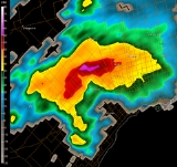
showed on weather radar
s a hook echo
, a BWER and a strong mesocyclone
but the vortex left the ground after the second tornado. Studies were made to try to explain the change in behavior to an extremely high producer of rain. One area of Thornhill
, just north of the Toronto City limits recorded 175mm (6.9") of rain in less than 1 hour.
Toronto is situated by Lake Ontario
and a lake breeze
often develops during the day. This wind brings cooler air at the surface and causes a marine temperature inversion which could have been enough to keep the rotation aloft. To the west of the city, there is the Niagara Escarpment
, reaching 1,500 feet above sea level, while the shores of Lake Ontario are just 250 feet ASL. This drop could equally have cut off the rotation from the surface.
The lightning shows that there was a strong peak during the F2 tornadoes, dominated by the positive cloud-to-ground strikes. Studies have shown that this is often the case in tornadic storms. It was followed by a sharp drop and then another peak, but this one dominated by negative lightning during the flooding phase of the storm.
 The twisters uprooted hundreds of trees, chewed the limbs off of countless others, downed power lines, tossed cars and trucks aside, and ripped into several homes, cottages and barns. In Guelph
and Orangeville
10,000 residents were left without power. No death or injuries were reported.
In Toronto, 103 mm of rain fell in one hour in North York and surrounding area, double the amount left by Hurricane Hazel
in 1954 (the heaviest rain from Hazel fell over Etobicoke and the Airport area). At the Meteorological Service of Canada
(MSC) Downsview headquarter, 130 mm of rain fell, 100 mm of them in less than an hour, a record for any storm in Toronto. A block or two to the north in Thornhill
, a weather watcher emptied her rain gauge at 175 mm. Rainfall totals from the storm exceeded 140 mm in parts in Concord
. A volunteer storm spotter reported a tornado in the north part of the city but it was not confirmed by Environment Canada
.
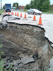
The rain washed out a portion of Finch Avenue
near Sentinel Ave in North York. It overflowed storm drains which caused severe basement flooding to many thousands of homes and two floors of the MSC building. Around Toronto, torrential rains snarled traffic and stranded drivers. Fire services responded to more than 1,000 calls. Marine services personnel rescued four people who fell into the fast-moving currents of the Don River.
Conestoga Lake
Conestoga Lake or Conestogo Lake may refer to one of two lakes:*Conestogo Lake, Ontario, Canada. A reservoir with a flood control dam....
, Fergus
Fergus, Ontario
Fergus is the largest community in Centre Wellington, a township within Wellington County in Ontario, Canada. It lies on the Grand River about 25 km north of Guelph.-History:...
, and Tavistock
East Zorra-Tavistock, Ontario
East Zorra-Tavistock is a township in south-western Ontario, Canada. It is part of Oxford County. The township had a population of 7,350 in the Canada 2006 Census.-Government:...
areas. A tornado was reported within the Toronto city limits, although this was never officially confirmed by the Meteorological Service of Canada
Meteorological Service of Canada
The Meteorological Service of Canada , also known as "The Canadian Weather Service", is a division of Environment Canada, which primarily provides public meteorological information and weather forecasts and warnings of severe weather and other environmental hazards...
. The storms morphed into heavy rain cells when reaching Toronto. The Insurance Bureau of Canada has estimated that insured losses were the highest in the province's history, exceeding $500 million Canadian dollar
Canadian dollar
The Canadian dollar is the currency of Canada. As of 2007, the Canadian dollar is the 7th most traded currency in the world. It is abbreviated with the dollar sign $, or C$ to distinguish it from other dollar-denominated currencies...
s, two and a half times that of Ontario's losses during the 1998 ice storm
North American ice storm of 1998
The North American ice storm of 1998 was a massive combination of five smaller successive ice storms which combined to strike a relatively narrow swath of land from eastern Ontario to southern Quebec to Nova Scotia in Canada, and bordering areas from northern New York to central Maine in the...
and the second largest loss event in Canadian history.
Meteorological events
On the early morning of August 19, a low pressure area was sitting over Northern MichiganMichigan
Michigan is a U.S. state located in the Great Lakes Region of the United States of America. The name Michigan is the French form of the Ojibwa word mishigamaa, meaning "large water" or "large lake"....
with a cold front southwestward. This same systems had been giving an outbreak of tornadoes over Wisconsin the day before. As shown in the map to the left, there was up to 50 mm of precipitable water in the air mass in the warm sector invading Southern Ontario with a strong southwesterly low level jet parallel to the cold front and the presence of an upper jet-stream. All of these were very favorable from the development of severe thunderstorms. Furthermore, the wind shear
Wind shear
Wind shear, sometimes referred to as windshear or wind gradient, is a difference in wind speed and direction over a relatively short distance in the atmosphere...
in the lower troposphere was creating a large helicity value conducive to a tornado potential.
With the advancing cold front, two lines of thunderstorms developed. The first one was near Stratford, Ontario
Stratford, Ontario
Stratford is a city on the Avon River in Perth County in southwestern Ontario, Canada with a population of 32,000.When the area was first settled by Europeans in 1832, the townsite and the river were named after Stratford-upon-Avon, England. It is the seat of Perth County. Stratford was...
(20 km west of Kitchener
Kitchener, Ontario
The City of Kitchener is a city in Southern Ontario, Canada. It was the Town of Berlin from 1854 until 1912 and the City of Berlin from 1912 until 1916. The city had a population of 204,668 in the Canada 2006 Census...
), and spread as far north as Georgian Bay
Georgian Bay
Georgian Bay is a large bay of Lake Huron, located entirely within Ontario, Canada...
near Collingwood, Ontario
Collingwood, Ontario
Collingwood is a town in Simcoe County, Ontario, Canada. Geographically, it is situated on Nottawasaga Bay at the southern point of Georgian Bay.-History:...
while the second one was following behind near the shores of Lake Huron
Lake Huron
Lake Huron is one of the five Great Lakes of North America. Hydrologically, it comprises the larger portion of Lake Michigan-Huron. It is bounded on the east by the Canadian province of Ontario and on the west by the state of Michigan in the United States...
. They tracked eastward and reached as far as Oshawa during the afternoon. Dozens of storm cells populated the line, two of them developing into tornadic supercell
Supercell
A supercell is a thunderstorm that is characterized by the presence of a mesocyclone: a deep, continuously-rotating updraft. For this reason, these storms are sometimes referred to as rotating thunderstorms...
s. At their worst, the tornadoes reached the F2
Fujita scale
The Fujita scale , or Fujita-Pearson scale, is a scale for rating tornado intensity, based primarily on the damage tornadoes inflict on human-built structures and vegetation...
level, with gusts between 180 and 250 km/h. Severe thunderstorm warning
Severe thunderstorm warning
A severe thunderstorm warning is issued when trained storm spotters or a Doppler weather radar indicate a strong thunderstorm is producing dangerously large hail or high winds, capable of causing significant damage. In the United States, it does not account for lightning or flooding...
s were sent, mentioning the possibility of tornadoes in view of the radar output and the potential analysis.
The main storm, later dubbed the Toronto Supercell, spawned a first tornado tracking through Milverton (43°34′N 80°56′W) to Conestogo Lake
Conestoga Lake
Conestoga Lake or Conestogo Lake may refer to one of two lakes:*Conestogo Lake, Ontario, Canada. A reservoir with a flood control dam....
(43.68579°N 80.730293°W) (west of Elmira
Elmira, Ontario
The town of Elmira in Ontario, Canada is the largest community within the Township of Woolwich in the Regional Municipality of Waterloo and is located 15 km to the north of the city of Waterloo.-History:...
) from 12:40 to 1:20 pm local time. A second twister moved from Salem
Salem, Ontario
Salem is a community located in the township of Centre Wellington, Ontario, Canada.Salem is the site of a gas station, local convenience store, two bridges over the Irvine River, a school, and a subdivision. It also has one traffic light, but has more gravel roads than paved ones...
(43°41′36"N 80°26′49"W) to Lake Belwood (43°46′5"N 80°20′8"W) (north of Guelph
Guelph
Guelph is a city in Ontario, Canada.Guelph may also refer to:* Guelph , consisting of the City of Guelph, Ontario* Guelph , as the above* University of Guelph, in the same city...
), passing just to the north of Fergus
Fergus, Ontario
Fergus is the largest community in Centre Wellington, a township within Wellington County in Ontario, Canada. It lies on the Grand River about 25 km north of Guelph.-History:...
10 minutes later. When the storm came close to the Greater Toronto Area
Greater Toronto Area
The Greater Toronto Area is the largest metropolitan area in Canada, with a 2006 census population of 5.5 million. The Greater Toronto Area is usually defined as the central city of Toronto, along with four regional municipalities surrounding it: Durham, Halton, Peel, and York...
, a tornado warning
Tornado warning
A tornado warning is an alert issued by government weather services to warn that severe thunderstorms with tornadoes may be imminent. It can be issued after a tornado or funnel cloud has been spotted by eye, or more commonly if there are radar indications of tornado formation...
was issued, but the storm changed its characteristics. It produced winds of well over 100 km/h, golf ball sized hail
Hail
Hail is a form of solid precipitation. It consists of balls or irregular lumps of ice, each of which is referred to as a hail stone. Hail stones on Earth consist mostly of water ice and measure between and in diameter, with the larger stones coming from severe thunderstorms...
, but mostly heavy rain flooding many parts of the city between 2 and 4 pm.
Finally, another severe storm passing Southeast of Stratford
Stratford, Ontario
Stratford is a city on the Avon River in Perth County in southwestern Ontario, Canada with a population of 32,000.When the area was first settled by Europeans in 1832, the townsite and the river were named after Stratford-upon-Avon, England. It is the seat of Perth County. Stratford was...
, in the Tavistock
East Zorra-Tavistock, Ontario
East Zorra-Tavistock is a township in south-western Ontario, Canada. It is part of Oxford County. The township had a population of 7,350 in the Canada 2006 Census.-Government:...
area (43.212513°N 80.847462°W), gave an F1 tornado with winds between 120 to 150 kilometres per hour by 3:20 pm.
Storm's characteristics
The Toronto Supercell maintained all the characteristics of a tornado producer as it approached the city. Convective storm detectionConvective storm detection
Convective storm detection is the meteorological observation of deep, moist convection and consists of detection, monitoring, and short-term prediction. This term includes the minority of storms which do not produce lightning and thunder. Convective storms can produce tornadoes as well as large...
showed on weather radar
Weather radar
Weather radar, also called weather surveillance radar and Doppler weather radar, is a type of radar used to locate precipitation, calculate its motion, estimate its type . Modern weather radars are mostly pulse-Doppler radars, capable of detecting the motion of rain droplets in addition to the...
s a hook echo
Hook echo
The hook echo is one of the classical hallmarks of tornado-producing supercell thunderstorms as seen on a weather radar. The echo is produced by rain, hail, or even debris being wrapped around the supercell...
, a BWER and a strong mesocyclone
Mesocyclone
A mesocyclone is a vortex of air, approximately 2 to 10 miles in diameter , within a convective storm....
but the vortex left the ground after the second tornado. Studies were made to try to explain the change in behavior to an extremely high producer of rain. One area of Thornhill
Thornhill, Ontario
Thornhill is a community in the Greater Toronto Area of Southern Ontario, Canada, located on the northern border of the city of Toronto. Once a municipal village, Thornhill is now a community and postal designation geographically split into two municipalities along Yonge Street, the city of...
, just north of the Toronto City limits recorded 175mm (6.9") of rain in less than 1 hour.
Toronto is situated by Lake Ontario
Lake Ontario
Lake Ontario is one of the five Great Lakes of North America. It is bounded on the north and southwest by the Canadian province of Ontario, and on the south by the American state of New York. Ontario, Canada's most populous province, was named for the lake. In the Wyandot language, ontarío means...
and a lake breeze
Sea breeze
A sea-breeze is a wind from the sea that develops over land near coasts. It is formed by increasing temperature differences between the land and water; these create a pressure minimum over the land due to its relative warmth, and forces higher pressure, cooler air from the sea to move inland...
often develops during the day. This wind brings cooler air at the surface and causes a marine temperature inversion which could have been enough to keep the rotation aloft. To the west of the city, there is the Niagara Escarpment
Niagara Escarpment
The Niagara Escarpment is a long escarpment, or cuesta, in the United States and Canada that runs westward from New York State, through Ontario, Michigan, Wisconsin and Illinois...
, reaching 1,500 feet above sea level, while the shores of Lake Ontario are just 250 feet ASL. This drop could equally have cut off the rotation from the surface.
The lightning shows that there was a strong peak during the F2 tornadoes, dominated by the positive cloud-to-ground strikes. Studies have shown that this is often the case in tornadic storms. It was followed by a sharp drop and then another peak, but this one dominated by negative lightning during the flooding phase of the storm.
Impacts
Guelph
Guelph is a city in Ontario, Canada.Guelph may also refer to:* Guelph , consisting of the City of Guelph, Ontario* Guelph , as the above* University of Guelph, in the same city...
and Orangeville
Orangeville, Ontario
Orangeville is a town in south-central Ontario, Canada, and the seat of Dufferin County.-History:Before European settlers, Orangeville was thought to be a native hunting ground...
10,000 residents were left without power. No death or injuries were reported.
In Toronto, 103 mm of rain fell in one hour in North York and surrounding area, double the amount left by Hurricane Hazel
Hurricane Hazel
Hurricane Hazel was the deadliest and costliest hurricane of the 1954 Atlantic hurricane season. The storm killed as many as 1,000 people in Haiti before striking the United States near the border between North and South Carolina, as a Category 4 hurricane...
in 1954 (the heaviest rain from Hazel fell over Etobicoke and the Airport area). At the Meteorological Service of Canada
Meteorological Service of Canada
The Meteorological Service of Canada , also known as "The Canadian Weather Service", is a division of Environment Canada, which primarily provides public meteorological information and weather forecasts and warnings of severe weather and other environmental hazards...
(MSC) Downsview headquarter, 130 mm of rain fell, 100 mm of them in less than an hour, a record for any storm in Toronto. A block or two to the north in Thornhill
Thornhill, Ontario
Thornhill is a community in the Greater Toronto Area of Southern Ontario, Canada, located on the northern border of the city of Toronto. Once a municipal village, Thornhill is now a community and postal designation geographically split into two municipalities along Yonge Street, the city of...
, a weather watcher emptied her rain gauge at 175 mm. Rainfall totals from the storm exceeded 140 mm in parts in Concord
Concord, Ontario
Concord is an unincorporated suburban industrial community in the City of Vaughan in York Region, located north of Toronto, Ontario, Canada. According to the 2001 Census, the community has 8,255 residents ....
. A volunteer storm spotter reported a tornado in the north part of the city but it was not confirmed by Environment Canada
Environment Canada
Environment Canada , legally incorporated as the Department of the Environment under the Department of the Environment Act Environment Canada (EC) (French: Environnement Canada), legally incorporated as the Department of the Environment under the Department of the Environment Act Environment...
.
The rain washed out a portion of Finch Avenue
Finch Avenue
Finch Avenue is an arterial thoroughfare and concession road which travels east–west through the city of Toronto. The road also has short extensions into Peel and Durham Regions as Peel Regional Road 2 and Durham Regional Road 37.-History:...
near Sentinel Ave in North York. It overflowed storm drains which caused severe basement flooding to many thousands of homes and two floors of the MSC building. Around Toronto, torrential rains snarled traffic and stranded drivers. Fire services responded to more than 1,000 calls. Marine services personnel rescued four people who fell into the fast-moving currents of the Don River.
Related articles
- Heat wave of 2006 derecho series, a three-day tornado outbreak and series of derechos in Southern Ontario and in the US.
- Southern Ontario Tornado Outbreak of 2009Southern Ontario Tornado Outbreak of 2009The Southern Ontario Tornado Outbreak of 2009 was a series of severe thunderstorms that spawned numerous tornadoes in Southwestern Ontario, Central Ontario and the Greater Toronto Area on August 20, 2009, and was the largest single-day tornado outbreak in Ontario history and the largest in...
, the highest tornado recorded during an outbreak in Canada. - The "Barrie" Tornado Outbreak of 1985, the deadly and the strongest tornado outbreak that occurred in Southern Ontario.
External links
- The Southern Ontario Severe Weather Event of Aug 19, 2005 by Collaborative Science, Technology, and Applied Research Program of the National Weather Service and the University of Albany, NY
- Report on the Fergus tornado by Dave Patrick, a storm chaser, with pictures of the damages
- Weather hazard statictics in Ontario by Environment Canada
- Spectacular Finch Ave. Toronto Flood by Watermainbreakclock.com